
It’s finally out – my article on how & why the Home Owners Loan Corporation made its #redlining maps: journals.sagepub.com/doi/full/10.11…. Here’s an illustrated thread summarizing the major findings … (1/19)
@SAGE_Publishing @HOLCRedlining @SACRPH @UrbanHistoryA
@SAGE_Publishing @HOLCRedlining @SACRPH @UrbanHistoryA
Previous scholars have disagreed on why exactly HOLC made these “security” (#redlining) maps & how it used them, what its mapmaking methodology was, whether it shared the maps with private industry, and the agency’s relationship to the Federal Housing Administration … (2/19)
Outstanding work by scholars like Ken Jackson, Amy Hillier, @MpeterF & @APaigeOutofHist sketch the broad outlines of HOLC's racist logic. However, no one (w/ partial exception of @HowellOcean) had tackled the uncatalogued 486 microfilm reels documenting HOLC operations… (3/19)
Using 1,000 pages of that microfilmed correspondence about the operations of HOLC’s Mortgagee Rehabilitation Division – a subunit that made the #redlining maps for its 1935-1940 City Survey – I reached some pathbreaking conclusions ... (4/19) 


First, I confirm @HowellOcean's observation: HOLC made its mortgage refinancing loans before launching the City Survey – 97% of these had closed when its now notorious maps started rolling out in early 1936. It *couldn’t* have used these to deny loans in other words … (5/19)
.@lwinling & I earlier expanded Hillier’s finding that HOLC lent to Black homeowners: journals.sagepub.com/doi/full/10.11…. Thus in framing HOLC #redlining as racial capitalism, we must heed NDB Connolly & others in recognizing the concept’s malleability + potential contradictoriness (6/19)
Just 13 field agents oversaw the 1935-36 City Survey operations, one for each HOLC Region (except for two each in the NE and Mid-Atlantic). Twelve had backgrounds in banking & finance, like Lloyd Wheeler & Alec Morgan, based out of Detroit & Atlanta respectively … (7/19)


These agents surveyed ~200 informants per city by mail & scheduled follow-up interviews with dozens to compile their reports. They explicitly told informants about project goals & showed them map drafts, so the City Survey was not “top secret” as is often assumed … (8/19)


Yet in what might come as a surprise, some of the informants HOLC-MRD agents approached were annoyed, noncooperative, or even hostile – complicating our ideas of the City Survey as a collaboration between the federal gov’t and real estate-home finance industry ... (9/19)
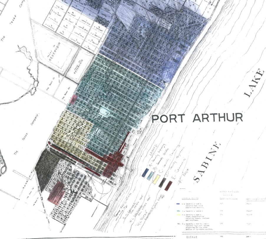
Making the maps was a tedious, technical process until HOLC started using photo-offset lithography in 1937; this explains the "handmade" appearance of early maps compared to later, as in these two Atlanta examples from 1936 & 1938 and a Seattle one from early 1936 ... (10/19)


Initial process was to outline the "security" areas in India ink, then photograph result for a b&w template that was used to make watercolored copies by hand; also these base maps were quite large as I confirmed on a visit to @USNatArchives this summer ... (11/19)


HOLC agents struggled to find usable base maps at the scale they wanted, which also were expensive, outdated, or copyrighted – so they took whatever they could get, like this freebie from an Albany, NY department store ... (12/19) Thanx @dphochfelder

HOLC didn't have any preexisting method, its MRD iterated the process as it went along; amazingly, for the first couple months Black neighborhoods were categorized as an asterisked, fifth grade – seen in these examples – before being merged into the "D" (red) category ... (13/19)


HOLC's sharing policy with regard to the final map copies was so restrictive that even Regional managers weren't given access until early 1936, leading them to withhold cooperation. Also, MRD agents were denied permission to share maps with informants they'd relied upon (14/19)
On HOLC's ties to the private real estate industry & academics who formulated racist land value theories, see my article with @lwinling: academic.oup.com/jah/article/10…. In short, HOLC didn't need to share its actual maps, instead it taught private industry how to redline ... (15/19)
Although HOLC forbade sharing its final map copies with private interests, its MRD definitely had covert exchanges with the FHA & shared 3 sets of City Survey final maps. Tellingly, MRD's DC offices were initially in the FHA building, not HOLC's! ... (16/19)


Made after all its loans were issued, HOLC’s initial use of these maps was to count the loans in each of its four "security grade" areas; in some cities – like Boston – HOLC found borrowers in "D" areas had best record of repayment, thus invalidating its assumptions ... (17/19)
An aspect of HOLC's racist record we should take a closer look at is its liquidation of foreclosed properties after 1936; HOLC clearly sold these off according to race, as seen in these advertisements I found at Atlanta History Center ... (18/19)


Much remains to be learned about post-1936 HOLC, FHA and their furthering of racist federal housing policies; I look forward to new research and continuing conversations. Special thanx to @cconnerrun for her insightful feedback & peerless editorial support! 😃(19/19)
Copying re: new #redlining article & 🧵@MehrsaBaradaran @WalterDGreason @TomSugrue @drlungamam @DanImmergluck @atboston @MapPrejudice @MapM8ker @benchansfield @elizabethkaygee @ChloeThurstonDC @m_r_glass @rmarchiel @gregory8jost @AmandaISeligman @EricMichaRhodes @robgioielli
• • •
Missing some Tweet in this thread? You can try to
force a refresh


