The Siege of Kherson is over.
The Siege of Crimea has begun.
I've laid out the logistics of the Kherson siege previously, plus the water implications for Crimea if Kherson's right bank fell.
Now it is time for a Crimean siege logistical 🧵
1/
The Siege of Crimea has begun.
I've laid out the logistics of the Kherson siege previously, plus the water implications for Crimea if Kherson's right bank fell.
Now it is time for a Crimean siege logistical 🧵
1/
https://twitter.com/TrentTelenko/status/1536833540217876483
The Siege of Crimea began before the Siege of Kherson ended, on October 8th 2022.
When the Kerch Straits road and rail bridge was bombed.
This attack cut Crimea off from its primary fuel supply, crippling VKS aviation based there.
2/
When the Kerch Straits road and rail bridge was bombed.
This attack cut Crimea off from its primary fuel supply, crippling VKS aviation based there.
2/
https://twitter.com/TrentTelenko/status/1579139255531896832
This loss of fuel for Russia's Crimean based aviation accelerated the Siege of Kherson's right bank by denying the VKS the closely based fuel it needed to contest Ukrainian air superiority.
This loss means a great deal for the Ukrainian Navy's Neptune ASCM launchers.
3/
This loss means a great deal for the Ukrainian Navy's Neptune ASCM launchers.
3/
Stanislav, Kherson Oblast represents a key piece of strategic Ukrainian terrain for the siege of Crimea for basing the Ukrainian Navy mobile Neptune anti-ship cruise missile launchers.
Their reach from there covers well south of the port of Sevastopol.
4/
Their reach from there covers well south of the port of Sevastopol.
https://twitter.com/TrentTelenko/status/1590788238565904398
4/
The Russian Black Sea Fleet operational patterns in screening Sevastopol have changed.
Whether from the drone boat bomb attack or the fall of the Dnipro's right bank increasing the Neptune's engagements range isn't clear.
It is consistent with both.
5/
Whether from the drone boat bomb attack or the fall of the Dnipro's right bank increasing the Neptune's engagements range isn't clear.
It is consistent with both.
5/
https://twitter.com/CovertShores/status/1591446332350267392
Given the changed operational pattern @CovertShores spotted, the ability of Russian Black Sea Fleet to move fuel by coastal tanker or fuel filled cistern rail cars by ferry to Sevastopol port has been fatally compromised.
6/
6/
https://twitter.com/TrentTelenko/status/1579139264792920065
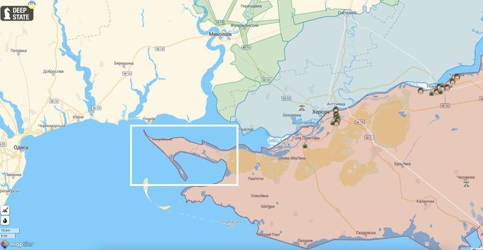
The most extreme western tip of occupied southern Ukraine is the Kinburn peninsula at the right bank of the Dnipro's mouth.
It is the most fuel starved territory in Russia's grasp & it has no air cover from AFU drones.
7/

It is the most fuel starved territory in Russia's grasp & it has no air cover from AFU drones.
7/
https://twitter.com/TrentTelenko/status/1591573353659531264

Worse, with the fall of Stanislav, the Kinburn peninsula is under the footprint of Ukrainian Army, drone directed, 155mm guns firing basic shells, AKA "Fire Control."
A Ukrainian helicopter and/or boat lifted light infantry force with Stugna-P ATGM,
8/
A Ukrainian helicopter and/or boat lifted light infantry force with Stugna-P ATGM,
8/
https://twitter.com/SmartUACat/status/1591462114237026305
...Switchblade drones, mortars and long range artillery radios that reach Stanislav would be able to take & potentially hold the Kinburn peninsula inside that artillery footprint.
Whether AFU actually does this is a different matter.
9/
Whether AFU actually does this is a different matter.
9/
The problem is the Russians have to honor this threat to the Western flank the Dnipro line.
Forcing the Russians to occupy Kinburn peninsula, which hasn't been fortified yet due to a lack of roads, gives the Ukrainians lots of Russian soft artillery targets out in the open.
10/
Forcing the Russians to occupy Kinburn peninsula, which hasn't been fortified yet due to a lack of roads, gives the Ukrainians lots of Russian soft artillery targets out in the open.
10/
If the Russians leave the Kinburn peninsula an unoccupied "Grey Zone." It becomes a sanctuary for Ukrainian Partisans, Special Forces and especially AFU drones.
And the threat to their Western flank remains as Russian aircover recedes.
11/
And the threat to their Western flank remains as Russian aircover recedes.
11/
And by that I mean the presence of AFU HIMARS on the Dnipro's right bank puts the Russian VKS helicopter base in Chaplynka in GMLRS range with all the explosive implications that fact represents.
See👇
12/
See👇
https://twitter.com/Tendar/status/1591338659957338112
12/
Nor is that the only GMLMS problem the Russian face in S. Ukraine. The following are within the GMLRS footprint:
o The E97 route from Western Crimea
o All the P57 route to the Black Sea
o The supply hub at Myrne
o The P47 route to Malachka
o The M14 route to Druzhbivka
13/
o The E97 route from Western Crimea
o All the P57 route to the Black Sea
o The supply hub at Myrne
o The P47 route to Malachka
o The M14 route to Druzhbivka
13/

The Russian Army's "Dnipro line" screening Crimea has an open western flank at the Kinburn peninsula, with its sea and ground lines of communications interdicted, and its Crimea supply source being short of fuel to support combat operations because of the bombed Kerch Bridge.
14/
14/
The reality of interdicted routes, short fuel and the threat of the open flank at the Kinburn peninsula represent the Russian Army's new logistical tar baby for the Siege of Crimea.
Just as the Kyiv 40 km parking lot, Snake Island, Chornobaevka & Kherson all were before it.
15/
Just as the Kyiv 40 km parking lot, Snake Island, Chornobaevka & Kherson all were before it.
15/

We are seeing yet again Ukraine's "Death of a Thousand Cuts" operational strategy at work against Russians.
Russia's trucks supporting the Dnipro line screening Crimea are in a kill jar of Ukraine's making.
Defeat & retreat, to & thru Crimea, are the only Russian outcomes
16/16
Russia's trucks supporting the Dnipro line screening Crimea are in a kill jar of Ukraine's making.
Defeat & retreat, to & thru Crimea, are the only Russian outcomes
16/16
• • •
Missing some Tweet in this thread? You can try to
force a refresh


