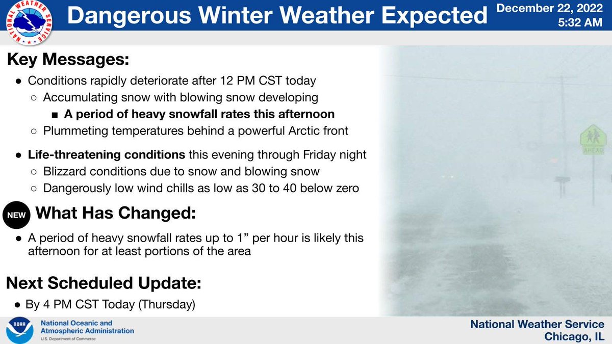
.Wed AM update! 1) Key messages on the dangerous winter weather Thursday into the holiday wknd. A powerful storm system will bring strong winds, falling and blowing & drifting snow, & extreme cold. Worst conditions: Thu-Fri. Threat for flash freeze on Thursday! #ILwx#INwx (1/5)
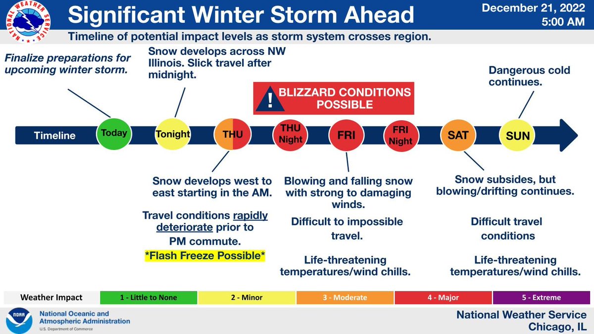
.2) Timeline graphic showing our latest thoughts on the upcoming dangerous winter weather. Travel conditions will likely rapidly deteriorate on Thursday AM through the afternoon from west to east. A flash freeze may cause icy roads during the accumulating snow! #ILwx#INwx (2/5)
.Impacts from the storm will be driven by combination of cold, wind & snow rather than snow alone. Don’t let your guard down from the moderate amounts of snow forecast; combined effects will lead to dangerous travel conditions which can become life threatening. #ILwx#INwx (3/5)
.Ground blizzard conditions: Even without major snowfall, strong winds lofting fresh snow can create treacherous travel due to near whiteout conditions, especially in open areas. Exposed north-south roads will be most susceptible to being drifted over with snow. #ILwx#INwx (4/5)
.In addition to falling and blowing snow, extreme cold will worsen the dangerous conditions Thu & Fri. Wind chills will drop to as low as 35 degrees below zero early Friday morning. Once the snow stops, dangerous cold will continue through the holiday weekend. #ILwx#INwx (5/5)
• • •
Missing some Tweet in this thread? You can try to
force a refresh
Good afternoon! We continue to work through hundreds of damage points from last week's severe weather. This thread will cover the latest information specific to the 7/15 (Monday) derecho. A summary map of all confirmed tornadoes from 7/15 is below. (1/10)
We have confirmed an additional 3 tornadoes, bringing the event total to 27. The new tornado
confirmations are: 1. Maple Park (EF-Unknown*), 2. O'Hare Airport (EF-0), and 3. Country Club Hills
(EF-0). The track maps for these 3 tornadoes are below. (2/10)
An EF-Unknown rating was assigned to the Maple Park tornado because it remained entirely in fields, for which no damage indicators/wind speed ratings currently exist. (3/10)
Check out this thread 🧵for our morning forecast graphics. Be sure to check these out this morning, we are in for an absolutely wild meteorological ride🎢with summer (record warmth), spring (severe storms?), and winter (snow/cold) weather all crammed into the next 24 hours!
Scattered t-storms are expected this evening (6PM til Midnight) with some of the storms potentially becoming severe. The primary threat is large hail, possibly up to 2” inches diameter. There is also a threat of locally damaging winds and a tornado or two. #ilwx #INwx
A powerful cold front will race quickly across the area this evening producing a 20-30°F temperature drop in just an hour or so and strong northwest winds gusting to 35-45 mph. A brief period of gusts over 50 mph are possible (30-40%) immediately behind the front. #ilwx #INwx
[3:20 PM CST 12/22] Here are key messages for the continued winter weather through tomorrow. Gusty winds and dangerously cold temperatures will become the norm tonight and especially Friday. Stay indoors, if you can! #ILwx#INwx
Although snow will taper from west to east overnight, increasingly gusty winds will lead to areas of blowing snow reducing visibility especially in open and rural areas. North to south-oriented roadways will be most susceptible to blowing snow. #ILwx#INwx
Temperatures will continue falling through the overnight hours with gusty winds leading to dangerous wind chills as low as 30 to 35 degrees below zero! If you must venture outdoors, cover up from head to toe in multiple layers. #ILwx#INwx
.Thu 12/22 AM Update! 1) Key Messages for the Dangerous Winter Weather Today-Early Saturday:
Conditions will deteriorate quickly late AM-aftn hours with snow, gusty winds & plummeting temperatures. The snow will taper on Friday though dangerous cold will remain. #ILwx#INwx (1/6)
.Arrival time of hazardous travel conditions today: Arctic front will sweep across the area from late AM thru early aftn from west to east, with accumulating snow, plummeting temps & gusty winds. A flash freeze may cause ice covered roads, topped by the snow. #ILwx#INwx (2/6)
.Periods of whiteout (blizzard) conditions likely later today thru Fri. night, especially in open areas. North-south roads most susceptible to blizzard conditions & drifts due to strong west-NW winds. With -30 to -40 wind chills, getting stranded can be deadly! #ILwx#INwx (3/6)
[4:00 AM 12/20] Confidence in a major winter storm continues to increase for the Thursday to Saturday time frame. Blizzard conditions are possible, and travel looks to become severely impacted, particularly Thursday night through Friday afternoon. #ILwx#INwx
This is an updated timeline graphic showing our latest thoughts on the upcoming major winter storm. Travel conditions will likely rapidly deteriorate Thursday afternoon and evening. #ILwx#INwx.
Here is a look at areas expected to see the most dangerous travel conditions. Rapidly deteriorating travel conditions are expected across Illinois through Thursday afternoon. If possible, consider alternate travel plans! #ILwx#INwx
Major winter storm Thu thru Sat with heavy snow, strong winds, severe blowing/drifting snow & bitter cold. The worst conditions will develop Thu evening & continue into Fri evening when a full fledged blizzard is possible along with dangerously cold temp. #ilwx#inwx
This is a look at impacts over space and time for the expected winter storm. Note the large footprint of this system, so travel will be impacted over much of the Upper Midwest and Great Lakes.
A significant winter storm is going to impact the region later this week. While some accumulating snow is possible during the day Thu, the most dangerous conditions, including a potential blizzard, is expected to develop Thu night & continue through Friday and Friday night.