NWS Chicago Profile picture
Dec 22 4 tweets 3 min read
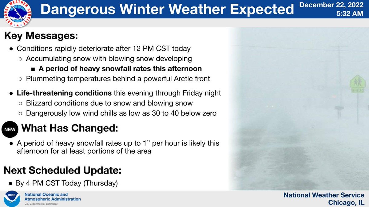
[3:20 PM CST 12/22] Here are key messages for the continued winter weather through tomorrow. Gusty winds and dangerously cold temperatures will become the norm tonight and especially Friday. Stay indoors, if you can! #ILwx #INwx Headline: Winter Weather Threats Continue.  Key Messages: Sn
Although snow will taper from west to east overnight, increasingly gusty winds will lead to areas of blowing snow reducing visibility especially in open and rural areas. North to south-oriented roadways will be most susceptible to blowing snow. #ILwx #INwx Headline: Winter Weather Threats Continue.  Sub Headline: Gu
Temperatures will continue falling through the overnight hours with gusty winds leading to dangerous wind chills as low as 30 to 35 degrees below zero! If you must venture outdoors, cover up from head to toe in multiple layers. #ILwx #INwx Headline: Winter Weather Threats Continue.  Sub Headline: Ex
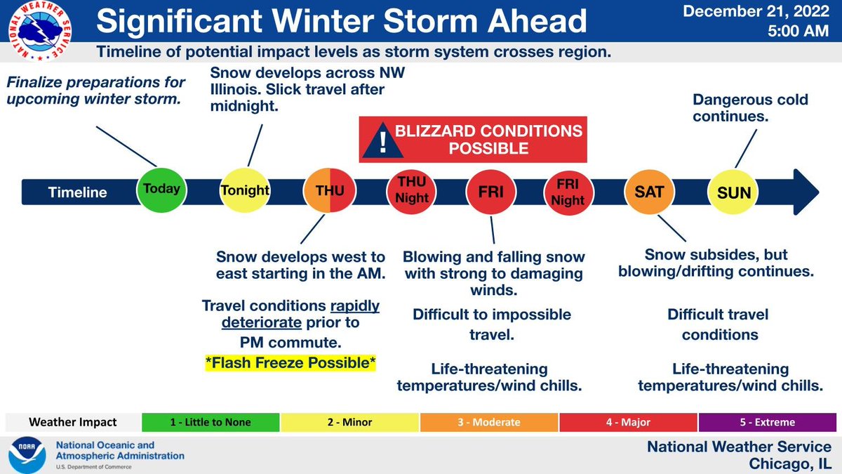
The cold stretch will only last through this weekend before temperatures warm into next week. A clipper system may move through the Mississippi River Valley on Monday bringing another shot of snow. #INwx #ILwx Headline: Winter Weather Threats Continue.  Sub Headline: Re

• • •

Missing some Tweet in this thread? You can try to force a refresh
 

Keep Current with NWS Chicago

NWS Chicago Profile picture

Stay in touch and get notified when new unrolls are available from this author!

Read all threads

This Thread may be Removed Anytime!

PDF

Twitter may remove this content at anytime! Save it as PDF for later use!

Try unrolling a thread yourself!

how to unroll video
  1. Follow @ThreadReaderApp to mention us!

  2. From a Twitter thread mention us with a keyword "unroll"
@threadreaderapp unroll

Practice here first or read more on our help page!

More from @NWSChicago

Dec 22
.Thu 12/22 AM Update! 1) Key Messages for the Dangerous Winter Weather Today-Early Saturday:
Conditions will deteriorate quickly late AM-aftn hours with snow, gusty winds & plummeting temperatures. The snow will taper on Friday though dangerous cold will remain. #ILwx #INwx (1/6) Headline: Dangerous Winter Weather Expected.  Key Messages:
.Arrival time of hazardous travel conditions today: Arctic front will sweep across the area from late AM thru early aftn from west to east, with accumulating snow, plummeting temps & gusty winds. A flash freeze may cause ice covered roads, topped by the snow. #ILwx #INwx (2/6) Headline: Dangerous Winter Weather Expected.  Sub Headline:
.Periods of whiteout (blizzard) conditions likely later today thru Fri. night, especially in open areas. North-south roads most susceptible to blizzard conditions & drifts due to strong west-NW winds. With -30 to -40 wind chills, getting stranded can be deadly! #ILwx #INwx (3/6) Headline: Dangerous Winter Weather Expected.  Sub Headline:
Read 6 tweets
Dec 21
.Wed AM update! 1) Key messages on the dangerous winter weather Thursday into the holiday wknd. A powerful storm system will bring strong winds, falling and blowing & drifting snow, & extreme cold. Worst conditions: Thu-Fri. Threat for flash freeze on Thursday! #ILwx #INwx (1/5) Headline: Significant Winter Storm Ahead.  Key Messages: Sno
.2) Timeline graphic showing our latest thoughts on the upcoming dangerous winter weather. Travel conditions will likely rapidly deteriorate on Thursday AM through the afternoon from west to east. A flash freeze may cause icy roads during the accumulating snow! #ILwx #INwx (2/5) Headline: Significant Winter Storm Ahead.  Sub Headline: Tim
.Impacts from the storm will be driven by combination of cold, wind & snow rather than snow alone. Don’t let your guard down from the moderate amounts of snow forecast; combined effects will lead to dangerous travel conditions which can become life threatening. #ILwx #INwx (3/5) Headline: Significant Winter Storm Ahead.  Sub Headline: Sno
Read 5 tweets
Dec 20
[4:00 AM 12/20] Confidence in a major winter storm continues to increase for the Thursday to Saturday time frame. Blizzard conditions are possible, and travel looks to become severely impacted, particularly Thursday night through Friday afternoon. #ILwx #INwx Image
This is an updated timeline graphic showing our latest thoughts on the upcoming major winter storm. Travel conditions will likely rapidly deteriorate Thursday afternoon and evening. #ILwx #INwx. Image
Here is a look at areas expected to see the most dangerous travel conditions. Rapidly deteriorating travel conditions are expected across Illinois through Thursday afternoon. If possible, consider alternate travel plans! #ILwx #INwx Image
Read 5 tweets
Dec 19
Major winter storm Thu thru Sat with heavy snow, strong winds, severe blowing/drifting snow & bitter cold. The worst conditions will develop Thu evening & continue into Fri evening when a full fledged blizzard is possible along with dangerously cold temp. #ilwx #inwx Headline: Significant Winte...
This is a look at impacts over space and time for the expected winter storm. Note the large footprint of this system, so travel will be impacted over much of the Upper Midwest and Great Lakes. Headline: Significant Winte...
A significant winter storm is going to impact the region later this week. While some accumulating snow is possible during the day Thu, the most dangerous conditions, including a potential blizzard, is expected to develop Thu night & continue through Friday and Friday night. Headline: Significant Winte...
Read 5 tweets
Jul 31
One of the very important jobs we have here at @NWSChicago is aviation forecasting, including for Chicago O'Hare and Midway airports. We work closely with the FAA providing forecasts that they utilize to make decisions, including which runways to use for landing and taking off.
Wind forecasts play a significant role in determining the runways to be used. During the spring & summer, lake breezes frequently result in wind shifts that cause the FAA to change runways being used, which during busy times involves moving around many planes on their way here.
Lake breezes in late summer tend to be weaker & more prone to "squirrelly" movements (due to the warmer lake), making them harder to predict. Forecasting the movements and timing of wind shifts associated with lake breezes is often a humbling task for NWS meteorologists!
Read 6 tweets
Mar 1
(1/5) This hour of tornado safety for Illinois #SeverePrep Week: Know the difference between a watch and a warning and what to do during a watch #ilwx
(2/5) Do you know the difference between severe weather WATCHES and WARNINGS? A WATCH means severe storms or tornadoes might form and affect your area. A WARNING means it’s time to take action! A severe storm or tornado is expected in your area. #SeverePrep #ILwx Image
(3/5) Specific terminology for tornadoes
• Note that a Tornado Emergency is an exceedingly rare situation (such as the Kentucky tornadoes back on Dec 10, 2021) with a confirmed violent tornado posing a severe threat to life & catastrophic damage
#SeverePrep #ilwx Image
Read 4 tweets

Did Thread Reader help you today?

Support us! We are indie developers!


This site is made by just two indie developers on a laptop doing marketing, support and development! Read more about the story.

Become a Premium Member ($3/month or $30/year) and get exclusive features!

Become Premium

Don't want to be a Premium member but still want to support us?

Make a small donation by buying us coffee ($5) or help with server cost ($10)

Donate via Paypal

Or Donate anonymously using crypto!

Ethereum

0xfe58350B80634f60Fa6Dc149a72b4DFbc17D341E copy

Bitcoin

3ATGMxNzCUFzxpMCHL5sWSt4DVtS8UqXpi copy

Thank you for your support!

Follow Us on Twitter!

:(