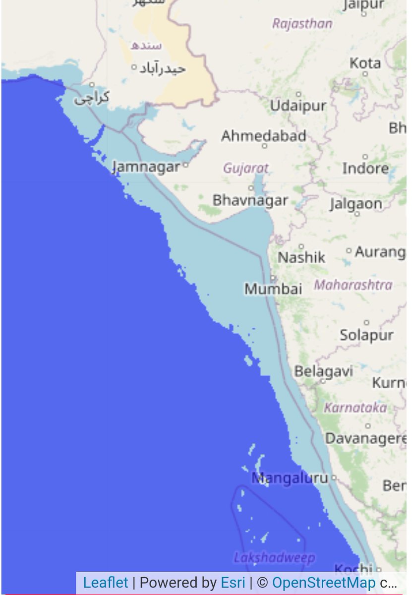
Ancient Indian metropolis predating #Harappan found submerged in Bay of Cambay 27 km off shore. Most of the artefacts found predates ice age as per Graham Cock. The lost city is 5x3 miles #Archaeology
#1
During ice age, the water levels were 140 meters lower and shorelines were deeper. The flood story seems to be true with this new discovery. During of sea shore, may be the prime reason for ice age people to move northwards. #Archaeology
#2
The other reason supporting the theory was rise in temperature by 8 degrees as Northern part of India became warmer. Surprisingly, house mouse migration to rest of the world 12kybp also substantiates this theory. #Archaeology
Discoveries at Gulf of Cambay had many similarities to the CITADEL, GREAT BATH and grid-iron pattern habitation sites grannery, etc. of the #Harappan civilization.
Dwarka could be missing link between harappan and it's its mother creators.
#4
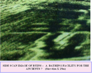
Sonar image of a Bathing Facility similar to Harappan 41x25 meters
#5
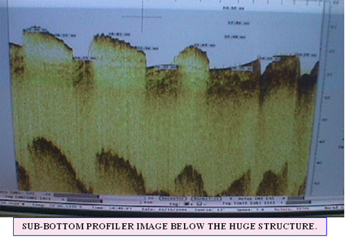
Basement of a major structure on a high ground 200mx45m
#6
A Granary with dimensions 190mx85m was found during sonography
#7
Buried settlement of 74 x 48m structure. Here also man made foundations like column can be clearly seen emerging from below the seabed and occur as standout features. Foundations have been dug up to 3-4 m deep in the soil.
#8
Long walls submerged in deep waters
#9
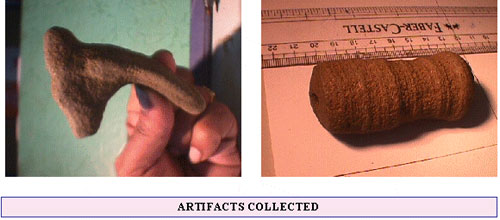
This piece of potshred is dated oldest than any fired object in the world
#10
A paleo channel to the North was also found active during 19500 ybp to 3000 ybp.
A youtube video coverage is here for eloquent users
Impatient ones can ff at 41 minutes mark.
#15
You can also contribute to preserve and explore these heritage by requesting @MinOfCultureGoI@nsitharaman@narendramodi to increase fund allocation for ASI activities.
Please RT this tweet
Diwali: diyas blaze during Kartik's darkest new moon (late Oct/early Nov).
Hanukkah: 8 candles in December.
Christmas: trees glow on Dec 25.
Yule, Dongzhi, Saturnalia... all cluster around winter solstice.
Why? 𝐇𝐮𝐦𝐚𝐧𝐬 𝐟𝐞𝐚𝐫 𝐝𝐚𝐫𝐤𝐧𝐞𝐬𝐬. 🕯️
2/ Rome, 217 BCE: Saturnalia begins Dec 17.
For one week, social order inverts. Slaves dine first. Masters serve. Courts close, gambling's allowed. Gifts exchanged: candles, wax figurines, pottery.
It celebrated Saturn's mythical "Golden Age"—a world without hierarchy.
Then normal life resumed.
3/ Fast-forward to 4th-century Rome: Christianity spreads.
Challenge: populations cling to winter festivals—Saturnalia, Sol Invictus (Dec 25 "Unconquered Sun"), local traditions.
Solution: 𝐚𝐝𝐚𝐩𝐭, don't erase.
Dec 25 becomes Christmas. Bible's silent on the date. Shepherds in fields suggest spring.
🧵 THREAD: Sambhar Lake didn’t become salty by accident.
It is the chemical footprint of the Aravallis. 🧂⛰️
Erase the hills, and the lake doesn’t shrink.
It dies.
#SaveAravalli
@narendramodi @PMOIndia @mygovindia @TVMohandasPai @CPCB_OFFICIAL @PIB_India @moefcc 1/
Sambhar Lake sits at the NE edge of the Aravalli Range.
This is not coincidence.
It is a tectonic basin formed along ancient Aravalli fault lines.
No Aravallis → no Sambhar.
Simple geology. Ignored policy.
2/ The Aravallis are ~3.2–2.5 billion years old.
Among the oldest folded mountains on Earth.
Sambhar exists because these rocks fractured, weathered, subsided.
Deep time created today’s salt.
1/ #GemsofASI #2 : British ASI manuals still rule India.
Not symbolically. Institutionally.
India became independent in 1947.
Its archaeology did not.
The Archaeological Survey of India still operates on conservation doctrines framed between 𝟏𝟗𝟎𝟒–𝟏𝟗𝟑𝟖, designed for colonial governance—not for a living civilisation.
#Decolonisation
2/ The 𝐀𝐧𝐜𝐢𝐞𝐧𝐭 𝐌𝐨𝐧𝐮𝐦𝐞𝐧𝐭𝐬 𝐏𝐫𝐞𝐬𝐞𝐫𝐯𝐚𝐭𝐢𝐨𝐧 𝐀𝐜𝐭, 𝟏𝟗𝟎𝟒 wasn’t written to protect Indian culture.
It was written to **control it**.
Its goals were explicit:
• Centralise authority
• Isolate monuments from locals
• Treat ritual use as damage
• Convert living sites into silent ruins
This logic never left ASI.
3/ British conservation doctrine insisted:
“Preserve the monument in the condition in which it is found.”
In Europe, that meant stabilising already-dead ruins.
In India, it meant 𝐟𝐫𝐞𝐞𝐳𝐢𝐧𝐠 𝐥𝐢𝐯𝐢𝐧𝐠 𝐭𝐞𝐦𝐩𝐥𝐞𝐬 𝐦𝐢𝐝-𝐛𝐫𝐞𝐚𝐭𝐡.
1/9 Ever hear of the Santhal Hul? Two years BEFORE the 1857 "Sepoy Mutiny" that history books love to call India's "first war of independence," the Santhal tribes rose up in 1855 against British exploitation. This was pure grassroots fury – bows and arrows vs. an empire. Let's dive in. 🏹
2/9 Background: The British "invited" Santhals to clear forests in the Rajmahal Hills (Damin-i-Koh, now Jharkhand/Bihar/WB) for farming and revenue. Sounded good – until zamindars, moneylenders (mahajans), and corrupt officials turned it into a nightmare. Debt traps, land grabs, exorbitant interest, forced labor. Santhals called outsiders "dikus" – exploiters.
3/9 The spark: Brothers Sidhu and Kanhu Murmu (plus Chand, Bhairav, and sisters Phulo & Jhano) claimed divine visions from Thakur Bonga (their god) commanding them to rebel and establish Santhal rule. On June 30, 1855, at Bhognadih village, 10,000+ Santhals gathered, took oaths, and declared war on the dikus.
ASI was founded in 1861, not to protect India’s past—but to manage it.
The Archaeological Survey of India was created by the British Empire, staffed by military engineers, and embedded inside colonial administration. The name "Survey" itself says it all.
This matters.
2/ ASI’s first Director General, Alexander Cunningham, was a Royal Engineers officer.
His training was not in living cultures.
It was in surveying, mapping, classification, and control.
Archaeology was an imperial tool.
3/ The mandate was clear:
• Identify ruins
• Catalogue monuments
• Standardise interpretation
• Detach sites from communities
A living civilisation is unpredictable.
Ruins are manageable.
🧵🏰 What kind of fort gets called "minor" at 2,700 feet with multi-tiered defences visible for miles?
The kind that didn't fit colonial narratives. Rayadurgam Fort, Anantapur — massive, sophisticated, erased.
We're still using their textbooks. The stones outlasted empires. The lie outlasted the stones.
#GemsofASI MNI#20
1/15
🛕 Built by 𝐉𝐮𝐧𝐠𝐚 𝐍𝐚𝐲𝐚𝐤𝐚 (1520s–30s), this was a Vijayanagara frontier fort controlling movement between AP & Karnataka. Colonial historians later downgraded it as "minor". Minor? A 2,700-ft citadel controlling two regions. But the empire narrative couldn't accommodate decentralised power. So it became "minor".
2/15
⛰️ At ~𝟐,𝟕𝟐𝟕 𝐟𝐭, Rayadurgam was built for surveillance: long-range visibility, multi-tiered access paths, natural cliffs turned to defence. But British-era archaeology catalogued it under 'regional ruins'. Right — altitude high, curiosity low. Classic imperial scholarship.