NWS San Diego Profile picture
Jan 8, 2023 8 tweets 4 min read Read on X
(1/8) We have quite the storm this week. We will lay out the impacts in this order:
1. Rain and Flooding
2. Wind
3. Snow
4. Hazardous Marine Conditions
Please read through the full thread & know that we are always looking at/updating the forecast as we get new information.
#CAwx Weather impacts this week: Heavy rain, wind and snow. Presen
(2/8) Scattered showers will be possible as early as Mon morning across northern areas & will spread to the southeast by Mon night. The heaviest/most widespread rain will occur Tue morning/afternoon, and flooding will be possible. T-storms will also be possible during this time. Heavy Rain: A strong storm system will move down the CA coas
A ⚠️ FLOOD WATCH ⚠️ has been issued for our northern areas, where the heaviest rain/highest rain rates are expected. Thunderstorms will be possible on Tuesday; rain rates may exceed 1"/hr with the heaviest cells. There will be a HIGH risk for flooding near recent burn scars. A FLOOD WATCH has been issued for Orange County, the Inland
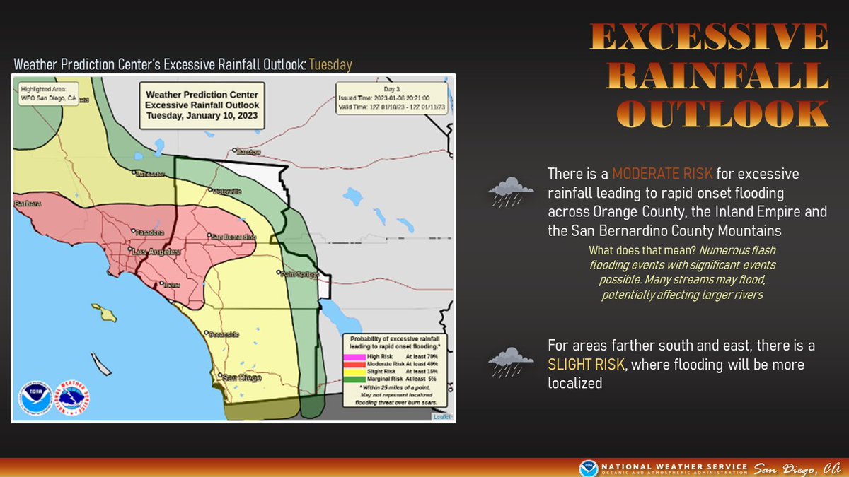
The @NWSWPC has expanded their MODERATE RISK for excessive rain leading to flooding into Orange County and portions of Riverside/San Bernardino Counties. This means there will be the potential for numerous flash flooding events, with significant flooding possible. There is a MODERATE RISK for excessive rainfall leading to r
Next up: Wind. A High Wind Warning has been issued for the San Bernardino County Mountains into the High Desert from Mon morning through Tue evening. Winds will increase tomorrow for these areas, spreading to the remainder of SoCal on Tuesday. A HIGH WIND WARNING has been issued for the San Bernardino C
Snow: this system is looking quite warm, with snow levels starting above 8000 feet on Mon, eventually falling as low as 5500 feet later in the day on Tuesday. Very heavy snow will be possible above 7000 feet. The storm system is looking warm, with snow levels starting
Finally, strong southerly winds and steep combined seas are likely for much of Monday and Tuesday. A Small Craft Advisory is in effect for the coastal waters for very hazardous boating conditions. A Small Craft Advisory is in effect for the coastal waters f
That's it! PLEASE remain weather aware the next several days. This could be a highly impactful system, and you don't want to be caught off guard with rapidly changing conditions. Use caution when traveling and allow for extra time to reach your destination.
#CAwx

• • •

Missing some Tweet in this thread? You can try to force a refresh
 

Keep Current with NWS San Diego

NWS San Diego Profile picture

Stay in touch and get notified when new unrolls are available from this author!

Read all threads

This Thread may be Removed Anytime!

PDF

Twitter may remove this content at anytime! Save it as PDF for later use!

Try unrolling a thread yourself!

how to unroll video
  1. Follow @ThreadReaderApp to mention us!

  2. From a Twitter thread mention us with a keyword "unroll"
@threadreaderapp unroll

Practice here first or read more on our help page!

More from @NWSSanDiego

Feb 3
(1/5) Heavy rain, strong winds, & high elevation snow this week. While there are still some details with timing that need to be worked out, confidence is growing the heaviest, most widespread precipitation will occur late Sun into Mon. Additional precipitation expected Tue-Fri. A strong atmospheric river is expected to impact California, including Southern California early this week. Periods of heavy snow above 6000-7000 ft, excessive rainfall and flooding, and strong winds are expected.
(2/5) Snow levels are expected to be 7000-8000 ft during the bulk of the precipitation Sun and Mon before falling to around 5500 ft Tue. That means below 7000 ft, rain will be the main hazard. Most of the precipitation will accumulate on the western San Bernardino mtns.  4-9 inches of rainfall are possible below 7000 ft from Sunday afternoon through  Tuesday. 10-20 inches of snow expected between 7000-8000 ft with 20-40 inches expected 8000+ ft. Precipitation accumulations will be highest on the west side of the San Bernardino mountains.
(3/5) Periods of heavy rain are expected Sun PM into Mon. Significant rainfall is expected for Orange County, portions of the Inland Empire, and the San Bernardino Mtns. Heavy rain is expected elsewhere but it will be more localized. Periods of rain will continue Tue-Fri. Periods of heavy rain are expected Sunday through Tuesday. Heaviest and most widespread rain expected Sunday night into Monday. Rainfall totals for Sunday-Tuesday are 3-5" in Orange County and the Inland Empire; 2-4" in San Diego Coast and Valleys; 4-9" below 7000 ft in the San Bernardino mountains; 2-4" in the San Diego and Riverside mountains; 0.5-1.5" in the deserts, higher totals in the high desert.
Read 5 tweets
Aug 20, 2023
Morning #HurricaneHilary 🧵

#Hilary continues its trek northward this morning as rain continues to overspread SoCal. Regardless of its eventual status as a hurricane or tropical storm, the forecasts for heavy rain and catastrophic flooding remain UNCHANGED. #CAwx
The latest track forecast for (now) Hurricane Hilary. It will continue moving northward while becoming a tropical storm later today, and then continue moving inland over California this evening and overnight.
The latest Excessive Rainfall Outlook from the Weather Prediction Center, highlighting a HIGH RISK of excessive rainfall across the mountains and deserts of Southern California, as well as a Moderate Risk surrounding the majority of Southern California.
Is it confusing/tricky to associate a "weakening storm" with a consistent catastrophic flooding threat? Absolutely! But these categories are based on wind alone, and while there will still be wind impacts, heavy rain and flooding remain by far and away the biggest threat. #CAwx
The latest rainfall forecast for Hilary. Coasts: 1.5-3.00 inches. Valleys: 2-4", local 5". Deserts: 3-4", local 6". Mountains: 4-8, Local 10-12".
A precipitation timing and intensity graphic for Hilary, depicting when areas will see light/moderate/heavy/torrential rainfall. Rain will increase in intensity later this morning and afternoon for many locations, especially in the mountains. Torrential rainfall is expected later this afternoon for the mountains and deserts, shown in purple. Heavy rain will occur across all of SoCal later today. Rain will steadily taper off Monday.
As mentioned earlier, there will still be some degree of wind impact, mainly in the mountains, deserts, and coastal foothills. The heavy rain and strong winds will create treacherous travel conditions. Unless it's essential, you might just wanna stay at home today. #CAwx
A map of peak wind gusts for Hilary. The mountains and deserts will see peak wind gusts of 50-65 mph, localized higher gusts in the mountains. Strong gusts also will occur over the coastal waters. Much of the lower elevations closer to the coast will see peak gusts of 30-40 mph.
A wind timing and intensity graphic for Hilary. Winds will begin to increase later this morning, strongest and most damaging in the mountains, deserts, coastal waters, and even some of the coastal valleys later this afternoon. Winds then steadily weaken later this evening and into Monday.
Read 4 tweets
Feb 22, 2023
(1/4) Here is our preliminary thoughts on the timing and intensity of the precipitation for the rest of this week. Off-and-on rain showers will be possible from late tonight through Thursday with light accumulations. Heavier and more widespread precip develops Thursday afternoon. A graphic showing precipitation timing and intensity across
(2/4) For Thursday through Saturday, an atmospheric river takes aim at Southern California, leading to widespread moderate to heavy rain, with the heaviest expected to occur on Friday. Heavy mountain snow will also be possible Thu-Sat, generally above 5000 feet.
(3/4) Here are our preliminary forecasted rain totals through Saturday. We are always looking at new model data, ingesting our new thoughts into the forecast & using our experience to adjust the forecast as the event approaches. Things change, resulting in updates to a forecast. Off-and-on, generally light, showers tonight through Thursda
Read 4 tweets
Feb 21, 2023
(1/4) ⚠️ HAZARDOUS TRAVEL IN THE MOUNTAINS THIS WEEK ⚠️ winds will rapidly increase this evening and peak overnight in the mountains. Snow levels will crash tomorrow morning, potentially as low as 2000 feet. READ THE WHOLE TWEET THREAD BELOW: Mountain Travel Forecast Feb 21-25.  DAMAGING WINDS WILL BE
(2/4) PLEASE NOTE: The snow accumulation graphic is only for snow accumulations through Thursday morning. ADDITIONAL HEAVY SNOW, ON THE ORDER OF SEVERAL FEET OF SNOW, WILL BE POSSIBLE THURSDAY NIGHT THROUGH SATURDAY.
(3/4) Winter Weather Advisories have been issued for LOCATIONS ABOVE 2500 FEET in the Inland Empire, and for LOCATIONS ABOVE 2000 FEET in the San Diego County Valleys through Thursday morning. Winter Storm Warnings are in effect for the mountains through Saturday.
Read 4 tweets
Feb 21, 2023
(1/3) In preparation for the hazardous conditions developing this week, we will be sharing safety information for the multiple hazards we are expecting. Up first, winter weather (snow) safety! ❄️☃️ Winter Travel Checklist  Au...
(2/3) There is a Winter Storm Warning in effect from tonight through Saturday for the San Bernardino/ Riverside/ San Diego County Mountains, Santa Ana Mountains. Expect damaging winds and extremely heavy snowfall.
(3/3) In addition, snow levels will be very low, with impacts possible 2000+ ft in the Inland Empire & 2500+ ft in the San Diego County Valleys. Travel will be hazardous due to snow showers combined with strong winds. A Winter Weather Advisory is in effect from Wed AM-Thu AM.
Read 4 tweets
Jan 7, 2023
(1/5) After a quiet weekend weather-wise, the next in a series of storm systems will begin to impact SoCal next week. Widespread moderate to heavy rain (with a slight chance of t-storms) and very strong winds can be anticipated. The heaviest precip is expected across SBCo Mtns. Hazardous Weather Outlook Jan 7 Elevated surf. A strong Paci
(2/5) Rain may develop as early as Mon morning across Orange/San Bernardino Counties, with light rain spreading southeastward through the day. However, an increase in activity is expected through Monday night, with with heaviest and most widespread rain occurring on Tuesday. Chance of precipitation Tuesday: Most areas in Southern Cali
(3/5) The @NWSWPC is outlooking a SLIGHT RISK for excessive rain leading to flash flooding across portions of Orange, San Bernardino and Riverside Counties. Rain rates could be very high in the strongest cells, so remain alert for flooding. Weather Prediction Center Excessive Rainfall Outlook. There
Read 5 tweets

Did Thread Reader help you today?

Support us! We are indie developers!


This site is made by just two indie developers on a laptop doing marketing, support and development! Read more about the story.

Become a Premium Member ($3/month or $30/year) and get exclusive features!

Become Premium

Don't want to be a Premium member but still want to support us?

Make a small donation by buying us coffee ($5) or help with server cost ($10)

Donate via Paypal

Or Donate anonymously using crypto!

Ethereum

0xfe58350B80634f60Fa6Dc149a72b4DFbc17D341E copy

Bitcoin

3ATGMxNzCUFzxpMCHL5sWSt4DVtS8UqXpi copy

Thank you for your support!

Follow Us!

:(