1/ #Tuesday #excursion in the area of Perachora, in a beautiful corner of Corinthia - north of the Isthmus - with rich archaeological interest and impressive landscapes. The ancient name of the area was Peiraion or Peraia, meaning "land beyond the sea", i.e. beyond the Isthmus. 

2/ First we went to the small, but particularly interesting archaeological site of the Sanctuary of Hera. We were surprised by the easy accessibility of a site located on a rugged beach of Melagavi Cape, the NW end of the Perachora Peninsula.
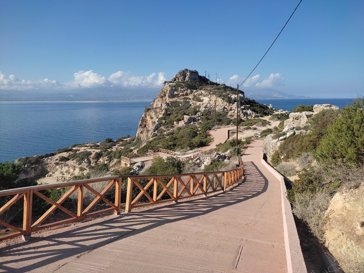
3/ At this place the Corinthians founded in the 9th century BC a famous sanctuary in which Hera was worshiped with two epithets: Akraia, i.e. patroness of the capes and Limnaia, i.e. patroness of the ports. ➡️

➡️ Such was the importance of the sanctuary for the Corinthians that local worship continued uninterrupted until the destruction of Corinth by the Romans in 146 BC.

4/It should be emphasized that this area had a constant habitation since the 3rd millennium BC with significant MBA / LBA residential and burial remains.We have mentioned the genetic footprint of Perachora with the appearance of strong steppe diffusion during the Middle Helladic.

5/ We must also note that near the sanctuary there was a small agricultural community closely connected to this, whose inhabitants were engaged in pear harvesting and cattle breeding, ➡️

➡️ while they had as their permanent concern their water supply, as evidenced by the existence of an extensive and technologically advanced rainwater collection and channelisation system.

6/ Heraion was not just any extra-urban sanctuary, but was located in a disputed border area, which was claimed by both the Corinthians, the Megarians and the Argives. ➡️

➡️ The Corinthian rule was asserted during the Archaic period, when the Corinthians extended their control over the entire Western Megaris and built an imposing archaic temple in the Doric order that replaced the earlier small Geometric apsidal temple.

7/ After 750 BC, Corinth emerges as a leading power in the Greek world, experiencing great economic prosperity and actively participating in the overseas expansion of Hellenism in the West, through the establishment of colonies and the expansion of commercial activities.

8/ The archaeological site is arranged on three levels: on the lower level and around the harbor are the main cult buildings, i.e. the Temple of Hera and the altar, but also auxiliary buildings, such as the west court and the stoa. ➡️

➡️ On the middle level, there are the double-aspidal cistern, the hestiatorion and the sacred pool, as well as parts of the water supply system. On the highest level, there is the hearth building, remains of various buildings, Doric walls and an extensive water supply network.


9/ In the harbour area, there are remains of the western pier, which was connected to the so-called west court, a large building that was once identified as the market place, but probably seems to have served the liturgical needs of the sanctuary and its visitors.


10/NW of the west court is the Archaic Doric temple of Akraia Hera, which was built in the 6th cent BC and from which survives, among other things, the rectangular stepped base of the cult statue of Hera, which was decorated with embossed rosettes at the front of the lower step.

11/ To the east of the temple, the Archaic altar is preserved, a long and narrow building with dimensions of approximately 3 x 5 m., originally decorated with triglyphs and metopes on all four sides, which was surrounded by an Ionic colonnade, probably after a later addition.

12/The monumental stoa was built in the Hellenistic period by Demetrius Poliorcetes, after the destruction of the west court by the Spartans, being a two-storey building in the Doric order, which served the needs of visitors and the display of the rich offerings of the sanctuary.

13/On the middle level is the most impressive monument of the archaeological site: the double-aspidal cirstern, which was an underground rainwater reservoir. It is a long narrow construction, of great inspiration and construction that managed to collect 300 cubic meters of water.

14/ Alongside is the hestiatorion which includes two square rooms and an antechamber. This particular building was used for holding symposiums - collective meals, while the participants, who were members of the elite, sat on comfortable rectangular stone couches.

15/ NE of the double aspidal cirstern is the so-called sacred pool, a small rainwater cirstern in which a number of elaborate votive offerings were found as part of some ritual activity, which is probably related to Strabo's mention that the sanctuary was also used as an oracle.

16/SE of the sacred pool was a monumental staircase that led to the raised level of Heraion, where the most important building was that of the hearth.Recent excavations have identified the character of the building as a place for holding official symposiums and religious rituals.


17/ In the center of the building, built in the 7th century BC, there was a large four-sided hearth filled with ashes, which was bordered by four stone slabs that had the inscription Hera Leukolenos (white-armed), which alludes to a Homeric aggressive designation of the goddess.

18/ In closing, it should be noted that some elements found during recent excavations suggest that in the spring there was a great celebration in honor of the Limnaia Hera, a period during which Corinthian ships were departing for their overseas voyages.
19/ In close proximity to the archaeological site is the beautiful stone lighthouse of Melagavi (Heraion Lighthouse), which first operated in 1897 guiding the ships which sail in the Corinthian Gulf and move towards the port and isthmus of Corinth.

20/ We then went to the lagoon of Vouliagmeni (in ancient times it was called Eschatiotis), which is impressively connected to the Gulf of Corinth through a narrow channel, very close to which the mentioned remains of a Protohelladic habitation have been identified. twitter.com/i/web/status/1…
21/ Ending our excursion and half an hour's drive from the lagoon, we went to an idyllic location directly across from the Alkyonides islands, one of the most earthquake-prone areas of Greece, called Cave of Seal.


22/ It is a rock formation, a natural arch above the blue-green waters of the sea, the result of seismic activity, which you approach via a inaccessible piny path and an steep downhill passage, where you hold on to a rope.


• • •
Missing some Tweet in this thread? You can try to
force a refresh