GemsOfINDOLOGY Profile picture
Feb 5, 2023 9 tweets 5 min read Read on X
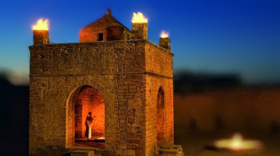
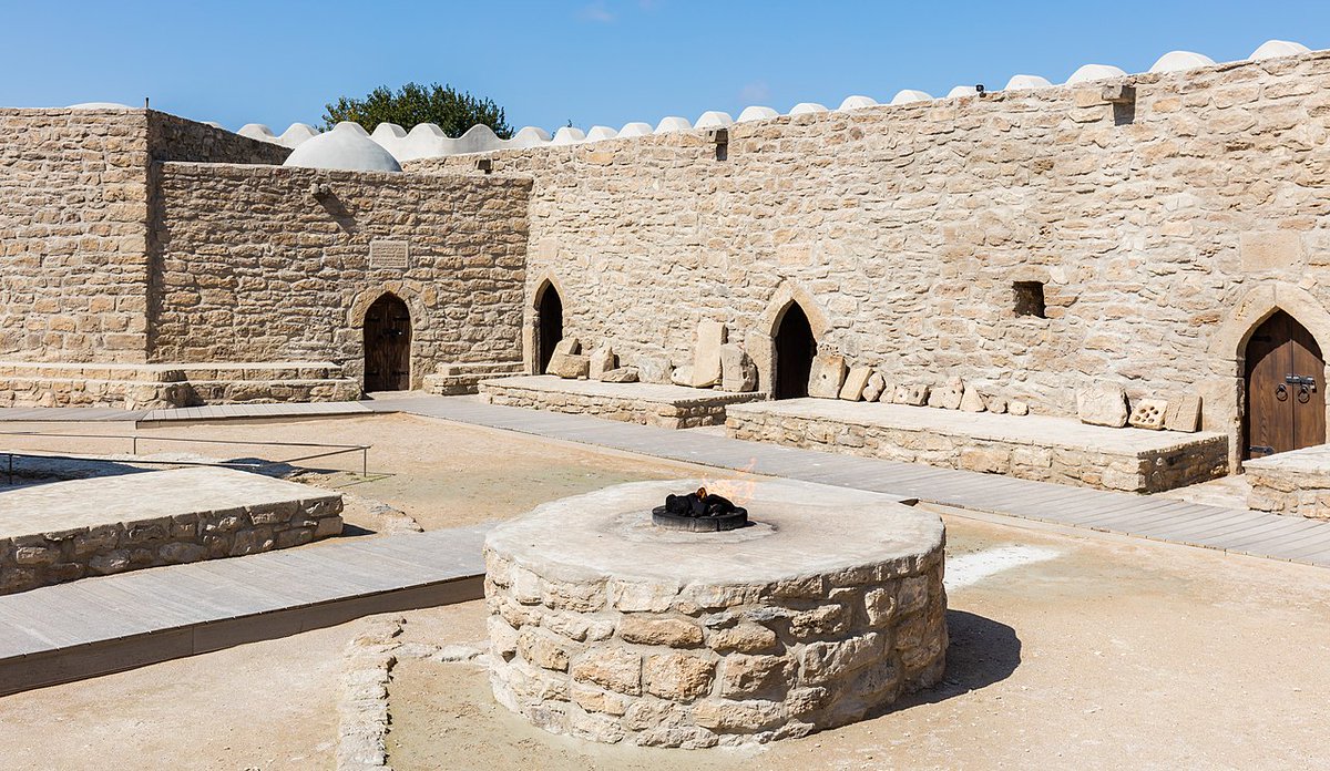
Ateshgah अतिशगाह of Baku called the "Fire Temple of Baku", is a castle-like Hindu temple in Surakhany town in Baku, Azerbaijan. It's flames are burning for a millenium from natural gas. It was built in 17th century

1/9
An inscription from the Baku Atashgah. The first line begins: I salute Lord Ganesha (श्री गणेशाय नमः) venerating Hindu God Ganesha, the second venerates the holy fire (जवालाजी, Jwala Ji) and dates the inscription to Samvat 1802 (संवत १८०२, or 1745-46 CE).

2/9
Inscribed invocation to Lord Shiva in Sanskrit at the Ateshgah.

3/9
An invocation to the oneness of existence in Dhan Dhan Satguru Sri Guru Granth Sahib ji ko

4/9
A dummy ascetic

5/9
Iranian Zoroastrians praying in Ateshgah of Baku.

6/9
Picture from various period including a postal stamp issued in 1919

7/9
You can read the unrolled version of this thread here: typefully.com/GemsOfINDOLOGY…

9/9

• • •

Missing some Tweet in this thread? You can try to force a refresh
 

Keep Current with GemsOfINDOLOGY

GemsOfINDOLOGY Profile picture

Stay in touch and get notified when new unrolls are available from this author!

Read all threads

This Thread may be Removed Anytime!

PDF

Twitter may remove this content at anytime! Save it as PDF for later use!

Try unrolling a thread yourself!

how to unroll video
  1. Follow @ThreadReaderApp to mention us!

  2. From a Twitter thread mention us with a keyword "unroll"
@threadreaderapp unroll

Practice here first or read more on our help page!

More from @GemsOfINDOLOGY

Dec 18
🧵 THREAD: Sambhar Lake didn’t become salty by accident.
It is the chemical footprint of the Aravallis. 🧂⛰️

Erase the hills, and the lake doesn’t shrink.
It dies.

#SaveAravalli Image
Image
Image
Image
@narendramodi @PMOIndia @mygovindia @TVMohandasPai @CPCB_OFFICIAL @PIB_India @moefcc 1/
Sambhar Lake sits at the NE edge of the Aravalli Range.
This is not coincidence.
It is a tectonic basin formed along ancient Aravalli fault lines.

No Aravallis → no Sambhar.
Simple geology. Ignored policy. Image
Image
Image
Image
2/
The Aravallis are ~3.2–2.5 billion years old.
Among the oldest folded mountains on Earth.

Sambhar exists because these rocks fractured, weathered, subsided.
Deep time created today’s salt.

Not “desert evaporation folklore”.
Read 10 tweets
Dec 17
1/
#GemsofASI #2 : British ASI manuals still rule India.
Not symbolically. Institutionally.

India became independent in 1947.
Its archaeology did not.

The Archaeological Survey of India still operates on conservation doctrines framed between 𝟏𝟗𝟎𝟒–𝟏𝟗𝟑𝟖, designed for colonial governance—not for a living civilisation.

#DecolonisationImage
2/
The 𝐀𝐧𝐜𝐢𝐞𝐧𝐭 𝐌𝐨𝐧𝐮𝐦𝐞𝐧𝐭𝐬 𝐏𝐫𝐞𝐬𝐞𝐫𝐯𝐚𝐭𝐢𝐨𝐧 𝐀𝐜𝐭, 𝟏𝟗𝟎𝟒 wasn’t written to protect Indian culture.
It was written to **control it**.

Its goals were explicit:
• Centralise authority
• Isolate monuments from locals
• Treat ritual use as damage
• Convert living sites into silent ruins

This logic never left ASI.Image
3/
British conservation doctrine insisted:
“Preserve the monument in the condition in which it is found.”

In Europe, that meant stabilising already-dead ruins.

In India, it meant 𝐟𝐫𝐞𝐞𝐳𝐢𝐧𝐠 𝐥𝐢𝐯𝐢𝐧𝐠 𝐭𝐞𝐦𝐩𝐥𝐞𝐬 𝐦𝐢𝐝-𝐛𝐫𝐞𝐚𝐭𝐡.

One rule. Two civilisations. Very different consequences.
scribd.com/document/44447…Image
Read 13 tweets
Dec 16
1/9
Ever hear of the Santhal Hul? Two years BEFORE the 1857 "Sepoy Mutiny" that history books love to call India's "first war of independence," the Santhal tribes rose up in 1855 against British exploitation. This was pure grassroots fury – bows and arrows vs. an empire. Let's dive in. 🏹Image
2/9
Background: The British "invited" Santhals to clear forests in the Rajmahal Hills (Damin-i-Koh, now Jharkhand/Bihar/WB) for farming and revenue. Sounded good – until zamindars, moneylenders (mahajans), and corrupt officials turned it into a nightmare. Debt traps, land grabs, exorbitant interest, forced labor. Santhals called outsiders "dikus" – exploiters.Image
3/9
The spark: Brothers Sidhu and Kanhu Murmu (plus Chand, Bhairav, and sisters Phulo & Jhano) claimed divine visions from Thakur Bonga (their god) commanding them to rebel and establish Santhal rule. On June 30, 1855, at Bhognadih village, 10,000+ Santhals gathered, took oaths, and declared war on the dikus.Image
Read 9 tweets
Dec 15
#GemsOfASI #1

ASI was founded in 1861, not to protect India’s past—but to manage it.

The Archaeological Survey of India was created by the British Empire, staffed by military engineers, and embedded inside colonial administration. The name "Survey" itself says it all.

This matters.Image
2/
ASI’s first Director General, Alexander Cunningham, was a Royal Engineers officer.

His training was not in living cultures.
It was in surveying, mapping, classification, and control.

Archaeology was an imperial tool. Image
3/
The mandate was clear:
• Identify ruins
• Catalogue monuments
• Standardise interpretation
• Detach sites from communities

A living civilisation is unpredictable.
Ruins are manageable. Image
Read 11 tweets
Dec 12
🧵🏰 What kind of fort gets called "minor" at 2,700 feet with multi-tiered defences visible for miles?

The kind that didn't fit colonial narratives. Rayadurgam Fort, Anantapur — massive, sophisticated, erased.

We're still using their textbooks. The stones outlasted empires. The lie outlasted the stones.

#GemsofASI MNI#20

1/15Ancient stone fort perched atop a rocky hill, winding battlements and stairways bathed in warm golden sunset light.
🛕 Built by 𝐉𝐮𝐧𝐠𝐚 𝐍𝐚𝐲𝐚𝐤𝐚 (1520s–30s), this was a Vijayanagara frontier fort controlling movement between AP & Karnataka. Colonial historians later downgraded it as "minor". Minor? A 2,700-ft citadel controlling two regions. But the empire narrative couldn't accommodate decentralised power. So it became "minor".

2/15Bearded, armored ruler with sword and staff overseeing laborers building a massive stone fort wall from scaffolding and blocks beneath a dusty sky
⛰️ At ~𝟐,𝟕𝟐𝟕 𝐟𝐭, Rayadurgam was built for surveillance: long-range visibility, multi-tiered access paths, natural cliffs turned to defence. But British-era archaeology catalogued it under 'regional ruins'. Right — altitude high, curiosity low. Classic imperial scholarship.

3/15Steep rocky hill with ruined stone fortifications and terraced walls, scattered vegetation and a rectangular ruin at the base under a cloudy sky
Read 15 tweets
Dec 9
1/ They taught us the British ended Sati. Saved us from our barbarism. 🕊️

Then why did Sati cases spike from 1 in 8 years to 5000 per year under British rule?

Why did cases DROP under Mughal emperors?

Let's talk about the history they never taught you. 🧵 Image
2/ From 1900 BCE to 1900 CE—2,500 years—historians found fewer than 500 verified Sati incidents.

That's one every 8 years. Rare. Tragic. But rare.

Between 1813-1829, just 16 years under British rule, they documented THOUSANDS.

What changed? Image
3/ In 1813, British administrators LEGALIZED Sati.

They created two categories:
"Legal" Sati (voluntary)
"Illegal" Sati (forced)

By defining legal Sati, they gave official sanction. Approval.

Court of Directors later admitted Indians saw this as a RECOMMENDATION. 💰 Image
Read 12 tweets

Did Thread Reader help you today?

Support us! We are indie developers!


This site is made by just two indie developers on a laptop doing marketing, support and development! Read more about the story.

Become a Premium Member ($3/month or $30/year) and get exclusive features!

Become Premium

Don't want to be a Premium member but still want to support us?

Make a small donation by buying us coffee ($5) or help with server cost ($10)

Donate via Paypal

Or Donate anonymously using crypto!

Ethereum

0xfe58350B80634f60Fa6Dc149a72b4DFbc17D341E copy

Bitcoin

3ATGMxNzCUFzxpMCHL5sWSt4DVtS8UqXpi copy

Thank you for your support!

Follow Us!

:(