Rob Larter Profile picture
Feb 19 3 tweets 3 min read
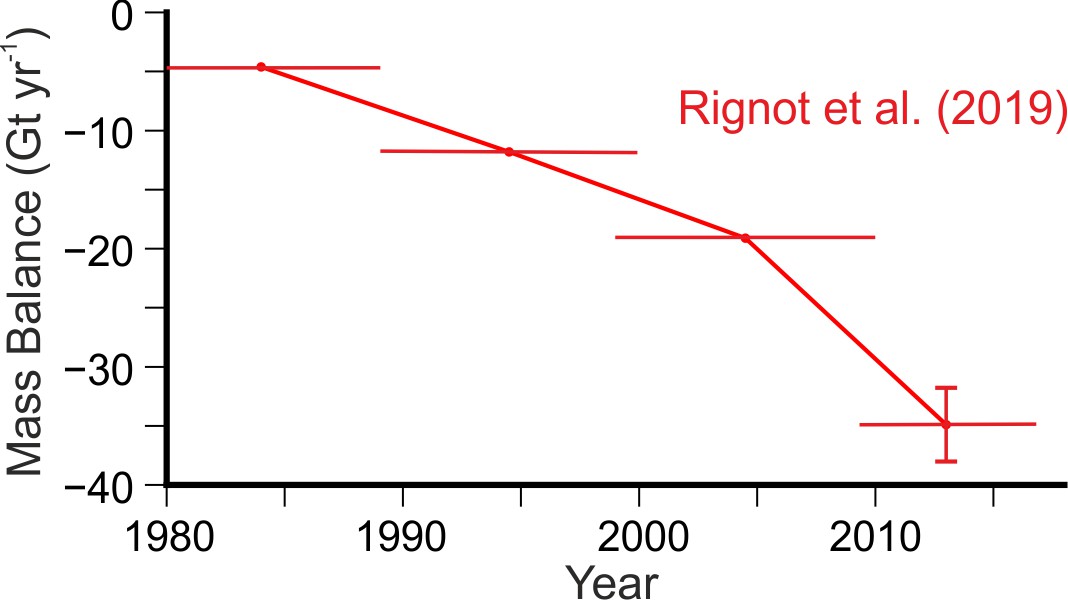
This may look like a very ordinary seascape, but it isn't. This view is at 72°S in the Bellingshausen Sea, #Antarctica, taken from RV Polarstern expedition #PS134. In a normal year there would be a lot of #seaice in this area, but this year there is none. 1/3
@AWI_Media @BAS_News This month has seen a new record minimum in #Antarctic #seaice extent since satellite records began more than 40 years ago. In the Bellingshausen Sea most of the ice was gone by the end of November. 2/3
@AWI_Media @BAS_News The minimum #seaice extent is highly variable from year to year, and we should be cautious about reading too much into a single year. However, #Antarctic annual and summer sea ice extents have now been below the long-term average for 7 years. A trend seems to be emerging. 3/3

• • •

Missing some Tweet in this thread? You can try to force a refresh
 

Keep Current with Rob Larter

Rob Larter Profile picture

Stay in touch and get notified when new unrolls are available from this author!

Read all threads

This Thread may be Removed Anytime!

PDF

Twitter may remove this content at anytime! Save it as PDF for later use!

Try unrolling a thread yourself!

how to unroll video
  1. Follow @ThreadReaderApp to mention us!

  2. From a Twitter thread mention us with a keyword "unroll"
@threadreaderapp unroll

Practice here first or read more on our help page!

More from @rdlarter

Feb 15, 2022
I was privileged to be invited to write a commentary on an interesting recent paper about the roughness of ice shelves by Watkins et al. (2021).
Commentary features this schematic diagram of the #ThwaitesGlacier Eastern Ice Shelf by @MarloWordyBird doi.org/10.1029/2021GL…
1/N
The paper that was the subject of the commentary is available here -
doi.org/10.1029/2021GL…
2/N
Background -
Ice shelves are floating extensions of glaciers that flow on beds hundreds of meters below sea level. They contribute "backstress" restricting outflow from many of the largest glaciers in Antarctica, thus limiting the Antarctic contribution to sea-level rise.
3/N
Read 15 tweets
Dec 18, 2021
Great to see @GlacierThwaites research covered in national media, but a few points in this @guardian article need correction or further explanation.
1/n theguardian.com/world/2021/dec…
Firstly, “great cracks and fissures” have not “opened up both on top of and underneath the Thwaites glacier” itself, but on the floating ice shelf in front of it.
2/n
Secondly, the processes the triggered the ultimate break-up of the Larsen B Ice Shelf were different from those that are destabilising the Thwaites Eastern Ice Shelf. Larsen B break-up was triggered by extensive surface melt filling crevasses and causing hydrofracture.
3/n
Read 8 tweets
Aug 15, 2020
While @GlacierThwaites fieldwork is postponed for the coming Antarctic summer, how much ongoing ice loss is there from #ThwaitesGlacier and nearby glaciers in the Amundsen Sea, and how big is their contribution to sea-level rise? Thread, 1/23
3 separate recent studies provide measurements for individual glaciers or drainage basins based on satellite remote sensing observations:
Rignot et al. (2019) doi.org/10.1073/pnas.1…
Shepherd et al. (2019) doi.org/10.1029/2019GL…
Smith et al. (2020) doi.org/10.1126/scienc…
2/23
In summary, the results of these studies show rates of net ice mass loss from Thwaites and nearby glaciers are now more than six times what they were 30 years ago. This graph shows the progressive increase in net ice loss from Thwaites from the results of Rignot et al. 3/23 Image
Read 23 tweets
Dec 21, 2019
A thread listing some of the sources of info, video clips and animations I included in my talk on The Polar Oceans at the outreach event following on from @BSRG19 earlier this week. Thanks to @FJavierHernnde2 for this photo and for organizing the event. 1/n Image
This figure, as seen in the previous tweet, shows an Antarctic-centred view of the global thermohaline circulation system from a recent article by @meredith_mmm challenger-society.org.uk/oceanchallenge…. It highlights how the Southern Ocean connects the other major oceans. 2/n Image
To further illustrate the thermohaline circulation I showed an animation by Greg Shirah of @NASAViz , which can be found at svs.gsfc.nasa.gov/3658. 3/n
Read 24 tweets

Did Thread Reader help you today?

Support us! We are indie developers!


This site is made by just two indie developers on a laptop doing marketing, support and development! Read more about the story.

Become a Premium Member ($3/month or $30/year) and get exclusive features!

Become Premium

Don't want to be a Premium member but still want to support us?

Make a small donation by buying us coffee ($5) or help with server cost ($10)

Donate via Paypal

Or Donate anonymously using crypto!

Ethereum

0xfe58350B80634f60Fa6Dc149a72b4DFbc17D341E copy

Bitcoin

3ATGMxNzCUFzxpMCHL5sWSt4DVtS8UqXpi copy

Thank you for your support!

Follow Us on Twitter!

:(