NWS Twin Cities Profile picture
Feb 21, 2023 6 tweets 3 min read Read on X
A significant winter storm remains on track to impact the region Tuesday afternoon through Thursday.

The heaviest snow & blizzard conditions are expected Wednesday afternoon through Thursday.

Significant travel impacts are anticipated until Friday. (1/6)
#mnwx #wiwx Map showing Winter Storm warning across central Minnesota. A
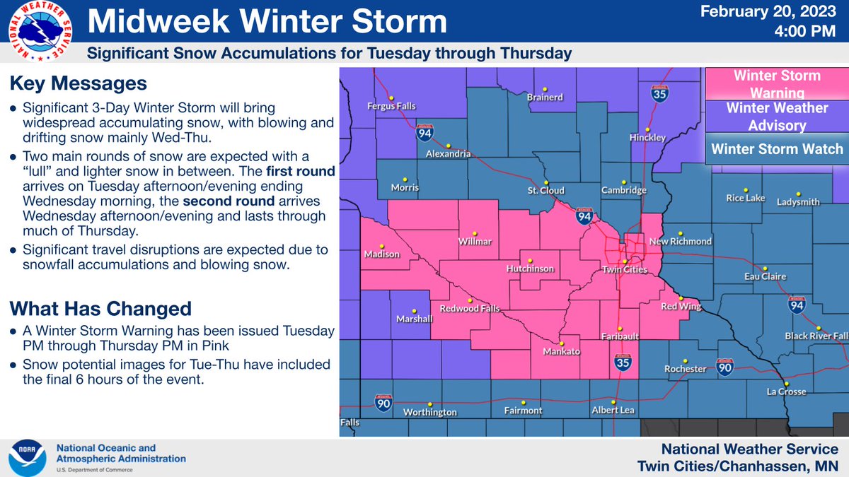
The storm will come in two waves:
Moderate to heavy snow begins Tuesday afternoon & ends Wednesday morning.
A relative lull in the snow is expected during the day Wednesday.
The heaviest snow & blizzard conditions develop late Wednesday afternoon & continue through Thursday
(2/6 Image shows timing of precipitation. Modertae to heavy snow
A foot of snow is almost guaranteed area-wide from both waves by the time snow ends Thursday. The Tuesday night/Wednesday morning phase will come as a narrower band of snow, which could miss far-southern MN & north-central MN & thus result in lower storm-total amounts.
(3/6) Map shows the entire area of central Minnesota & Western Wis
Snowfall amounts of 16-20" are most likely from central Minnesota into west-central Wisconsin where the heaviest snow from both waves is forecast to occur. Localized amounts around 2 feet (24") are possible.
(4/6) Map shows probabilities of greater than 18 inches of snow hi
Gusty northwest winds over 40 mph will develop Wednesday afternoon as the heaviest snow begins with the second phase of this system.
Blizzard conditions are possible across open areas with many roads potentially remaining impassable into Friday.
(5/6) Map shows forecast wind gusts Wednesday afternoon through Th
Significant travel impacts are expected Tuesday afternoon through Thursday.
There will be a few hours on Wednesday to clear snow & possibly get around, before the heaviest snow begins Wednesday afternoon through Thursday.

Prepare & plan ahead for these major disruptions!
(6/6) Image shows what you can do expect with 12-24 inches of snow

• • •

Missing some Tweet in this thread? You can try to force a refresh
 

Keep Current with NWS Twin Cities

NWS Twin Cities Profile picture

Stay in touch and get notified when new unrolls are available from this author!

Read all threads

This Thread may be Removed Anytime!

PDF

Twitter may remove this content at anytime! Save it as PDF for later use!

Try unrolling a thread yourself!

how to unroll video
  1. Follow @ThreadReaderApp to mention us!

  2. From a Twitter thread mention us with a keyword "unroll"
@threadreaderapp unroll

Practice here first or read more on our help page!

More from @NWSTwinCities

Mar 22
Here is a look at a storm total snow map Sunday through Tuesday.

There are a few factors that will make measuring difficult and could lead to amounts being lower than depicted, including...

- Long duration of snowfall, which allows for compaction between rounds of snow (1/4) Image of storm total snow map sunday through tuesday showing amounts of a foot or more from the Twin Cities and northwest. Lower amounts from 8-12 inches in southeastern Minnesota.  Text on the slide is as follows. Snow Amount Considerations This event will be long duration, spanning Sunday through Tuesday. It will not be snowing the entire time, and there will be breaks between rounds of heavier snow. Snow will compact during the breaks, which may lead to underdone measurements unless you measure every few hours and use a snowboard. Blowing snow will make it hard to measure, especially on ...
To mitigate compaction, measurements will need to be taken every few hours preferably using a snowboard.

- Blowing snow, especially for Sunday, making measuring difficult due to drifting.

Taking multiple measurements and averaging them is a method to help mitigate this (2/4)
- Strong winds resulting in fragmentation of snowflakes, leading to lower snow ratios.

There is not a good way for observers to mitigate this issue. When snowflakes fragment, they turn thin almost needle-like in shape.

- Rain will mix with snow later in the event (3/4)
Read 4 tweets
Dec 3, 2020
1) White Christmas Musings...

The snow depth in the Twin Cities was zero this morning. A snow depth of a trace (less than half an inch) or less has been observed on December 3rd in 64 of the 121 years in the period of record (through 2019).
2) To be considered a "White Christmas", an inch or more of snow depth is required. Of the 64 years with a trace or less of snow depth on December 3rd, 22 of them had a trace or less of snow depth on Christmas Day.
3) The remaining 42 years saw an inch or more of snow on the ground on Christmas Day, with 14 of them seeing 5" or more on the ground, and 5 of them seeing 10" or more on the ground.
Read 5 tweets

Did Thread Reader help you today?

Support us! We are indie developers!


This site is made by just two indie developers on a laptop doing marketing, support and development! Read more about the story.

Become a Premium Member ($3/month or $30/year) and get exclusive features!

Become Premium

Don't want to be a Premium member but still want to support us?

Make a small donation by buying us coffee ($5) or help with server cost ($10)

Donate via Paypal

Or Donate anonymously using crypto!

Ethereum

0xfe58350B80634f60Fa6Dc149a72b4DFbc17D341E copy

Bitcoin

3ATGMxNzCUFzxpMCHL5sWSt4DVtS8UqXpi copy

Thank you for your support!

Follow Us!

:(