NWS Twin Cities Profile picture
Official Twitter account for the National Weather Service Twin Cities, Minnesota. Details: http://t.co/DT7PGbdIaq
Mar 22 4 tweets 2 min read
Here is a look at a storm total snow map Sunday through Tuesday.

There are a few factors that will make measuring difficult and could lead to amounts being lower than depicted, including...

- Long duration of snowfall, which allows for compaction between rounds of snow (1/4) Image of storm total snow map sunday through tuesday showing amounts of a foot or more from the Twin Cities and northwest. Lower amounts from 8-12 inches in southeastern Minnesota.  Text on the slide is as follows. Snow Amount Considerations This event will be long duration, spanning Sunday through Tuesday. It will not be snowing the entire time, and there will be breaks between rounds of heavier snow. Snow will compact during the breaks, which may lead to underdone measurements unless you measure every few hours and use a snowboard. Blowing snow will make it hard to measure, especially on ... To mitigate compaction, measurements will need to be taken every few hours preferably using a snowboard.

- Blowing snow, especially for Sunday, making measuring difficult due to drifting.

Taking multiple measurements and averaging them is a method to help mitigate this (2/4)
Feb 21, 2023 6 tweets 3 min read
A significant winter storm remains on track to impact the region Tuesday afternoon through Thursday.

The heaviest snow & blizzard conditions are expected Wednesday afternoon through Thursday.

Significant travel impacts are anticipated until Friday. (1/6)
#mnwx #wiwx Map showing Winter Storm warning across central Minnesota. A 
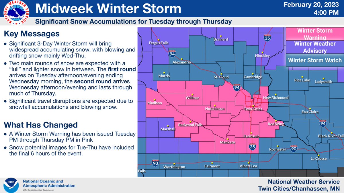
The storm will come in two waves:
Moderate to heavy snow begins Tuesday afternoon & ends Wednesday morning.
A relative lull in the snow is expected during the day Wednesday.
The heaviest snow & blizzard conditions develop late Wednesday afternoon & continue through Thursday
(2/6 Image shows timing of precipitation. Modertae to heavy snow
Dec 3, 2020 5 tweets 1 min read
1) White Christmas Musings...

The snow depth in the Twin Cities was zero this morning. A snow depth of a trace (less than half an inch) or less has been observed on December 3rd in 64 of the 121 years in the period of record (through 2019). 2) To be considered a "White Christmas", an inch or more of snow depth is required. Of the 64 years with a trace or less of snow depth on December 3rd, 22 of them had a trace or less of snow depth on Christmas Day.