A boulevard is a wide street with trees along its sides. The word comes from Dutch and means bulwark/ rampart. The earliest boulevards were built in the ancient Middle East. Paris has some of the most famous boulevards from the 17th and 18th centuries.
A thread on boulevards 🧵
A thread on boulevards 🧵

There are many examples of boulevards around the world, each with its own history and charm. Some of them are:
Champs Elysees in Paris, France: One of the most famous and elegant boulevards in the world, lined with luxury shops, cafes, museums and monuments.
Champs Elysees in Paris, France: One of the most famous and elegant boulevards in the world, lined with luxury shops, cafes, museums and monuments.

Commonwealth Avenue Mall in Boston, USA: A green oasis in the heart of the city, featuring statues of historical figures and a wide pedestrian path

Passeig de Gracia in Barcelona, Spain: A showcase of modernist architecture, including works by Antoni Gaudi and Lluis Domenech i Montaner.

Eastern Parkway in New York City, USA: A cultural corridor connecting Prospect Park with Brooklyn Museum and Brooklyn Botanic Garden

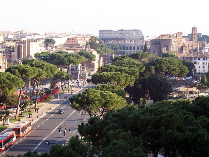
Via dei Fori Imperiali in Rome, Italy: A grand avenue that runs through the ancient Roman Forum and leads to the Colosseum.
Most boulevards came with the removal of city walls.
For example, in Paris, many of the boulevards were created by demolishing the medieval walls that surrounded the city and replacing them with wide avenues that allowed for better circulation and defense.
For example, in Paris, many of the boulevards were created by demolishing the medieval walls that surrounded the city and replacing them with wide avenues that allowed for better circulation and defense.
Some of these boulevards are still named after the old gates that marked the entrances to the city, such as Porte Saint-Denis or Porte Saint-Martin.

Boulevards transformed cities in different ways. In Paris, boulevards were part of a massive urban renewal project led by Baron Haussmann under Napoleon III in the mid-19th century.
The aim was to modernize the city, improve its sanitation, traffic, security and aesthetics, and create a unified architectural style. The boulevards also had a political dimension, as they made it easier for troops to suppress rebellions and harder for barricades to be erected

Elsewhere, boulevards were built along the former city walls after they became obsolete due to advances in artillery. This created more space for development and circulation around the historic centers. Vienna’s Ringstrasse, Brussels’ Petite Ceinture or Amsterdam’s Singelgracht.
Vienna: The city has a famous boulevard called Ringstrasse, which was built in the 19th century on the site of the former city walls. It circles around the historic center and showcases many architectural styles and landmarks such as city hall, Parliament, Opera House & Museums
The boulevards of Brussels are a series of tree-lined avenues that replaced the old city walls in the early 19th century. They form a ring around the historic Old Town of inner Brussels. The Central Boulevards are part of this ring that were constructed after covering r. Senne
Such as Boulevard Anspach: A pedestrian zone that runs through the heart of Brussels and features shops, cafes, cinemas and cultural venues.

Amsterdam:
Stadhouderskade: A long street that follows the Singelgracht canal and passes by many museums such as Rijksmuseum. There are currently plans by @UNStudio_Arch to make it more green.
Stadhouderskade: A long street that follows the Singelgracht canal and passes by many museums such as Rijksmuseum. There are currently plans by @UNStudio_Arch to make it more green.

Buenos Aires: The city was inspired by Paris and adopted a similar urban plan in the late 19th and early 20th centuries. It built several grand boulevards, such as Avenida de Mayo, Avenida 9 de Julio and Avenida Corrientes, that showcased its diversity and cultural vitality.


Los Angeles: The city developed its own style of boulevards in the 20th century, influenced by car culture, Hollywood glamour and suburban sprawl. Some of its iconic boulevards are Sunset Boulevard, Hollywood Boulevard and Wilshire Boulevard.

Boulevards were some of the first urban planning innovations that made access to green publicly available in urban areas and not just for the aristocracy.
However, some choices of trees are good for certain conditions, but not for others, since they are mostly chosen for their aesthetic qualities and maintenance requirements and not necessarily to support biodiversity within cities.
For example, plane trees are popular in Paris because they can tolerate pollution and pruning, but they may also suffer from diseases and pests. Maple trees are attractive for their fall colors, but they may also have shallow roots that can damage sidewalks or pipes.
We need new typologies of green streets that can capture global public imagination and become mainstream. These will become more and more important as our cities face more climate extremities.
#urbanism
#urbanism
• • •
Missing some Tweet in this thread? You can try to
force a refresh