Daniel Swain Profile picture
Mar 16 4 tweets 3 min read
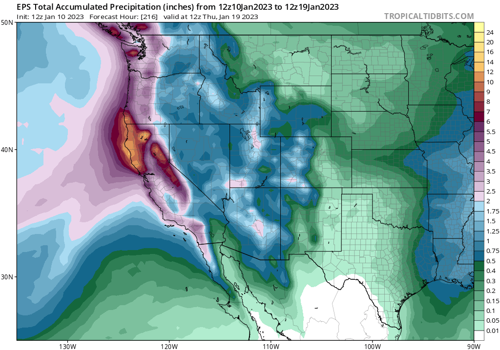
Brief thoughts on likely return to active weather pattern in CA after a much-needed several day break right now. There is *high* confidence that wet and cool conditions will return next week, but right now there is *low* confidence in strength of storms. #CAwx #CAwater (1/4) Time series plot from ECMWF...
Ensembles suggest that there is very high likelihood that unsettled and occasionally stormy conditions return to most of CA by early next wk. But vast majority of ensemble members suggest this will involve series of weak to moderate systems vs. major storms. #CAwx #CAwater (2/4)
Also, for the moment, it looks like these are more likely to be colder (snow-accumulating) storms once again, with less runoff than recent events. So this pattern might actually stave off substantial snowpack melting yet further-at least into April. #CAwx #CAwater (3/4)
So for the moment, I am not seeing a hugely concerning flood signal for next wk despite return of a rainy/snowy pattern. That said, soils are saturated & rivers are already running high--so it wouldn't take much of an upward shift in predictions to cause problems. (4/4) #CAwx

• • •

Missing some Tweet in this thread? You can try to force a refresh
 

Keep Current with Daniel Swain

Daniel Swain Profile picture

Stay in touch and get notified when new unrolls are available from this author!

Read all threads

This Thread may be Removed Anytime!

PDF

Twitter may remove this content at anytime! Save it as PDF for later use!

Try unrolling a thread yourself!

how to unroll video
  1. Follow @ThreadReaderApp to mention us!

  2. From a Twitter thread mention us with a keyword "unroll"
@threadreaderapp unroll

Practice here first or read more on our help page!

More from @Weather_West

Mar 12
Brief thread about...snow. As of this weekend, the Southern Sierra now appears to have largest snowpack in recorded history (as measured by snow water equivalent, or SWE). Not just for the calendar date, but for *any* date! #CAwx #CAwater [1/n] SWE time series trace from DWR for the major California Sier
As I earlier noted was plausible, the "warm" atmospheric river storm on Fri actually *increased* net watershed SWE substantially--partly because it still snowed at high elevations, but also because lower elevation snowpack absorbed a lot of rainwater! #CAwx #CAwater [2/n]
This map plot of the SWE change over the past 24 hours really tells the tale--much snow melting and SWE losses below about 4.5k ft in elevation but large *gains* above that level. Classic "warm-ish" storm dipole pattern! #CAwx #CAwater [3/n] 24 hr SWE change map for California. It depicts SWE loss at
Read 8 tweets
Mar 9
A few storm updates following my session Wed PM:
Event still largely on track, but two modest shifts that could affect impacts:
1) Storm may not be quite as warm across central & northern Sierra; could see some very heavy snowfalls above 6,500 ft once again.
#CAwx #CAwater [1/5]
2) Rainfall may be a bit heavier and more concentrated across the northern portion of central CA (but slightly less to north). This means flood risk in Monterey County (including Big Sur Coast), as well as southern Sierra & foothills, has increased somewhat. #CAwx [2/5]
3) Still not expecting widespread major river flooding. HOWEVER, localized significant flooding of creeks & streams is likely, and *possibly* on a few smaller rivers in the above-mentioned areas, due to combo of heavy rain & snowmelt below ~4,500ft elev. #CAwx [3/5]
Read 5 tweets
Feb 16
Lot of hype right now regarding supposed potential for widespread "sea level snowfall" later next week NorCal.

That almost certainly isn't going to happen (for variety of reasons). But some unusually low elevation snowfall (to 1000-1,500 feet or so) is certainly possible. #CAwx
Yes, I know that the coarse-resolution ensemble models are showing accumulating sea level snowfall for SF/Sacramento. They are very likely wrong--and the same models' *own thermal profiles* are not supportive of snow in these areas with this pattern! #CAwx
It is *extremely* difficult to generate widespread snowfall to sea level in central/northern CA. Very cold air aloft sometime happens, but getting the freezing level all the way to the surface takes an exceptional weather pattern. #CAwx
Read 7 tweets
Jan 11
Additional widespread precipitation is likely over the next 8-9 days over the northern 2/3 of CA, and it will be heavy at times (especially northern third of CA). Strongest storm, with some more heavy rain, wind, and thunderstorms, is due in on Sat. #CAwx #CAwater [1/4] Projected precipitation map from ECMWF ensemble depicting wi
However, these are primarily areas that have not been nearly as wet as central CA recently. Also, these will generally be colder storm systems, bringing a greater balance of snow (vs rain) in mountains & somewhat limiting higher elevation runoff. #CAwx #CAwater [2/4]
For these reasons, although there will be *some* additional flooding, it increasingly look like *most* of CA will probably thread the needle--thereby avoiding a more widespread/severe flood scenario. Massive Sierra snowfalls are possible during this period! #CAwx #CAwater [3/4]
Read 4 tweets
Jan 2
Okay, folks. Starting to look like it's going to be a rough 10+ days from a flood risk perspective in Northern California, with a series of very wet & high-impact storms. Brief thread now; blog post late this PM; YouTube live Q&A Tue. [1/n] #CAwx #CAwater
The next inbound storm looks like it will be quite strong. A rapidly deepening surface low (i.e., meteorological "bomb cyclone") will remain well offshore, but the associated warm and cold fronts will bring widespread heavy rain and strong winds to NorCal later Wed. #CAwx [2/n] Map showing ECMWF model representation of "bomb cyclone
This storm would be fairly notable in its own right, as it will be associated with an unusually well-defined warm *and* cold frontal passages and an exceptionally moist and relatively warm #AtmosphericRiver. #CAwater #CAwx [3/n] Map depicting ECMWF representation of Wednesday storm, inclu
Read 17 tweets
Dec 29, 2022
Some thoughts on impacts from ongoing and likely prolonged very wet spell in NorCal. (Short thread). TL;DR: widespread heavy precipitation is likely, with mostly minor flood issues becoming more widespread this weekend & *possibly* more significant next week. [1/n] #CAwx #CAwater
Lighter precipitation continues today, but the next significant storm will be this weekend. This will come in the form of a moderately strong low pressure system coupled with a robust, warm, and relatively slow-moving atmospheric river. #CAwx #CAwater [2/n] Image
This New Year's storm will bring heavy rainfall to essentially all of NorCal, and widespread precipitation to SoCal as well. This storm will be quite warm, too, with very high freezing levels initially bringing rain even at 7,000 feet. #CAwx #CAwater [3/n] Precipitation map from ECMW...
Read 8 tweets

Did Thread Reader help you today?

Support us! We are indie developers!


This site is made by just two indie developers on a laptop doing marketing, support and development! Read more about the story.

Become a Premium Member ($3/month or $30/year) and get exclusive features!

Become Premium

Don't want to be a Premium member but still want to support us?

Make a small donation by buying us coffee ($5) or help with server cost ($10)

Donate via Paypal

Or Donate anonymously using crypto!

Ethereum

0xfe58350B80634f60Fa6Dc149a72b4DFbc17D341E copy

Bitcoin

3ATGMxNzCUFzxpMCHL5sWSt4DVtS8UqXpi copy

Thank you for your support!

Follow Us on Twitter!

:(