GeoConfirmed UKR.
On March 14, 2023, the US released a statement that an MQ-9 "Reaper" was hit by a Russian SU-27 fighter.
Russia claimed it did not came into contact with the unmanned aerial vehicle.
Who is lying?
1/x to xx/End
On March 14, 2023, the US released a statement that an MQ-9 "Reaper" was hit by a Russian SU-27 fighter.
Russia claimed it did not came into contact with the unmanned aerial vehicle.
Who is lying?
1/x to xx/End
Statement of the US: (By CNN)
“Our MQ-9 aircraft was conducting routine operations in international airspace when it was intercepted and hit by a Russian aircraft, resulting in a crash and complete loss of the MQ-9"
Source: edition.cnn.com/2023/03/14/pol…
2/x
“Our MQ-9 aircraft was conducting routine operations in international airspace when it was intercepted and hit by a Russian aircraft, resulting in a crash and complete loss of the MQ-9"
Source: edition.cnn.com/2023/03/14/pol…
2/x

Statement of the Russia: (By Russia Today)
"The Russian fighters did not use weapons, did not come into contact with the UAV, and returned safely to their home base."
rt.com/russia/572980-…
3/x
"The Russian fighters did not use weapons, did not come into contact with the UAV, and returned safely to their home base."
rt.com/russia/572980-…
3/x

So the question is now: Who is lying?
2 days after the incident the US released the footage claimed to be from the incident.
4/x
2 days after the incident the US released the footage claimed to be from the incident.
4/x
What do we see?
Camera, filming from underneath a big drone: An Unarmed General Atomics MQ-9 Reaper intelligence and surveillance drone.
en.wikipedia.org/wiki/General_A…
5/x
Camera, filming from underneath a big drone: An Unarmed General Atomics MQ-9 Reaper intelligence and surveillance drone.
en.wikipedia.org/wiki/General_A…
5/x

When?
In the late afternoon of 14 March the first reports found their way to twitter. (time = CET)
In the article of RT is stated that EUCOM waited almost 12 hours to comment on it.
It's likely this incident happened in the morning of 14 MAR.
Can we proof this?
7/x
In the late afternoon of 14 March the first reports found their way to twitter. (time = CET)
In the article of RT is stated that EUCOM waited almost 12 hours to comment on it.
It's likely this incident happened in the morning of 14 MAR.
Can we proof this?
7/x


Breakdown of the footage.
00.00
Based on the screen compass of the Reaper and the angle of the footage compared to the wing the drone is flying NNE.
The horizon on the left side of the image is lighter than the right side. So this should be sunrise at the East. = morning.
8/x
00.00
Based on the screen compass of the Reaper and the angle of the footage compared to the wing the drone is flying NNE.
The horizon on the left side of the image is lighter than the right side. So this should be sunrise at the East. = morning.
8/x

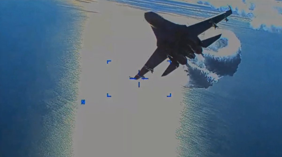
The footage shows the approach of the SU-27 from behind.
9/x
9/x

00.08
The SU-27 releases his fuel when he fly's by on a very short distance.
10/x
The SU-27 releases his fuel when he fly's by on a very short distance.
10/x

00.10
The footage is interfered by this fuel release.
Reaper still flying NNE.
After confirmation by aviation experts: there is not a chance this fuel release was by accident.
This is intentional.
11/x
The footage is interfered by this fuel release.
Reaper still flying NNE.
After confirmation by aviation experts: there is not a chance this fuel release was by accident.
This is intentional.
11/x

00.22
New frame, we don't know the time difference between this frame and previous one.
Green = landmass.
Orange = Reaper changed direction and is now flying NW.
Red = SU-27 approaching from behind.
12/x
New frame, we don't know the time difference between this frame and previous one.
Green = landmass.
Orange = Reaper changed direction and is now flying NW.
Red = SU-27 approaching from behind.
12/x

00.27
The second time an SU-27 flies by while releasing its fuel. Now we know for sure this is intentional.
The drone is directly flying away from the sun based on the water reflection.
13/x
The second time an SU-27 flies by while releasing its fuel. Now we know for sure this is intentional.
The drone is directly flying away from the sun based on the water reflection.
13/x

00:28
This time the SU-27 was very close.
14/x
This time the SU-27 was very close.
14/x

00.35
The images were now completely interrupted. Meaning the fuel was released closer/"better" to damage the Reaper and/or the Su-27 hit the Reaper.
15/x
The images were now completely interrupted. Meaning the fuel was released closer/"better" to damage the Reaper and/or the Su-27 hit the Reaper.
15/x

00.39 - New frame.
One of the propeller blades is curved and broken halfway.
16/x
One of the propeller blades is curved and broken halfway.
16/x

Between 00.15 and 00.20 you can see that the propeller blades are still in a good shape.
So not only did they intentionally dump fuel on the Reaper. They hit it to...
17/x
So not only did they intentionally dump fuel on the Reaper. They hit it to...
17/x
00.39.
We see a landmass and the drone is flying SW now, away from the landmass.
It's important to understand that this drone is flying high and has a very good camera. So we can't estimate how fare the drone is flying from the landmass.
But can we GeoLocate it?
18/x
We see a landmass and the drone is flying SW now, away from the landmass.
It's important to understand that this drone is flying high and has a very good camera. So we can't estimate how fare the drone is flying from the landmass.
But can we GeoLocate it?
18/x


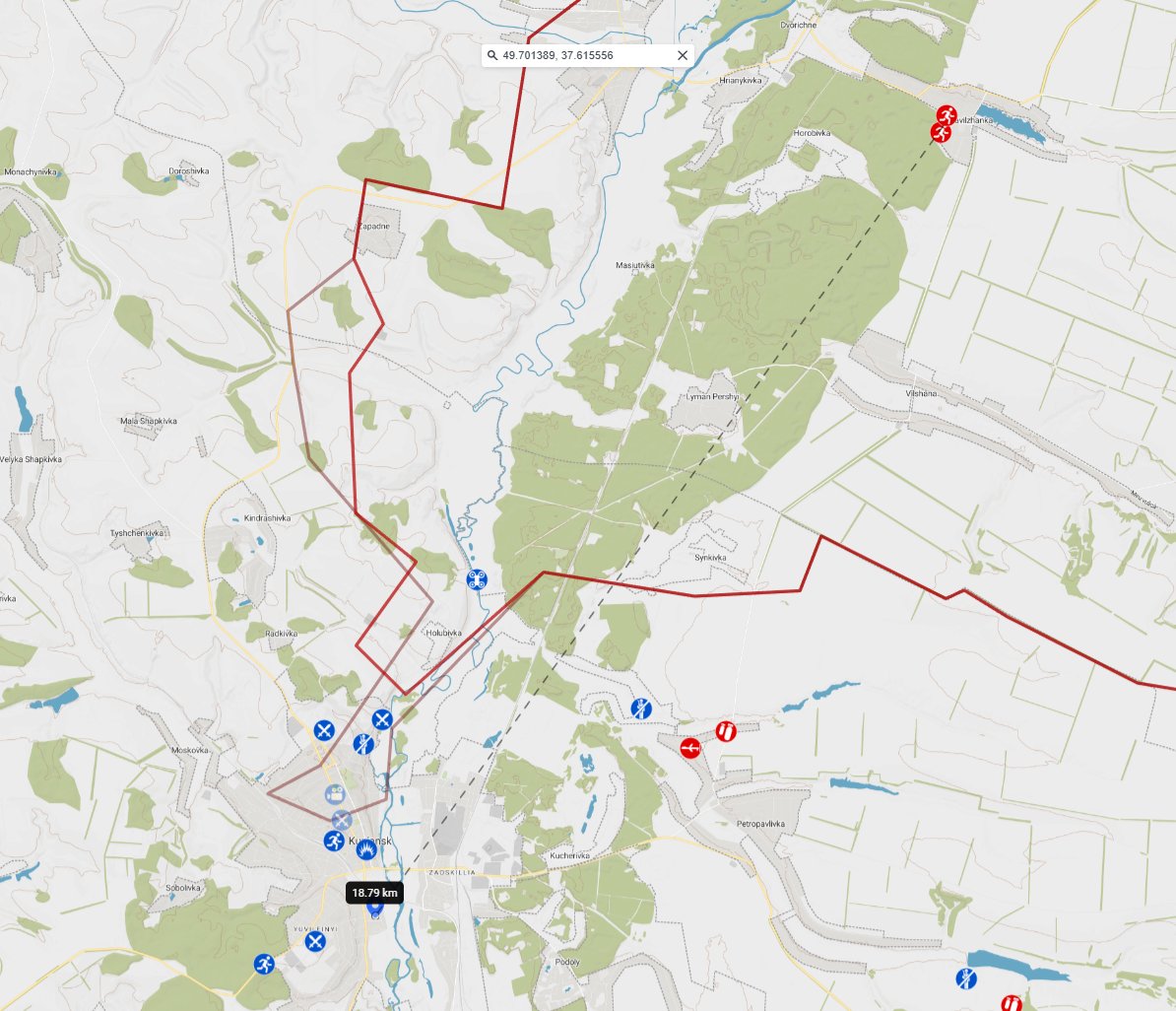
Rough estimation:
20/x
20/x

Very rough estimation of the flight path.
We know which directions the drone was flying in for each encounter. And we know how to orientate relative to the mountains, so this is a very rough flight path. (without knowing the distance to the shoreline.)
21/x
We know which directions the drone was flying in for each encounter. And we know how to orientate relative to the mountains, so this is a very rough flight path. (without knowing the distance to the shoreline.)
21/x
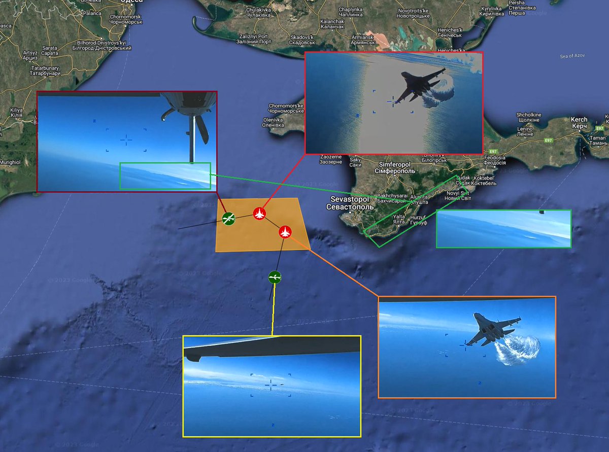
And what about the time?
We have a reflection of the sun and we have the island and we know its morning.
Our estimation: between 08.00 and 09.00 local time, morning of 14 March.
22/x
We have a reflection of the sun and we have the island and we know its morning.
Our estimation: between 08.00 and 09.00 local time, morning of 14 March.
22/x

With this estimation we went looking for what news outlets estimated: CNN (Western) and Rybar (Russian) published also an estimation on the location.
The location given by @CNNPolitics seems impossible due to the viewing angle on the ridge.
23/x
The location given by @CNNPolitics seems impossible due to the viewing angle on the ridge.
23/x


Now we can take a closer look at the statements of both parties.
🇷🇺
"The UAV was flying towards the Russian border without an active transponder, in clear violation of the restricted area established for the conduct of the special military operation, the ministry said."
24/x
🇷🇺
"The UAV was flying towards the Russian border without an active transponder, in clear violation of the restricted area established for the conduct of the special military operation, the ministry said."
24/x

🇺🇸
“Our MQ-9 aircraft was conducting routine operations in international airspace when it was intercepted and hit by a Russian aircraft, resulting in a crash and complete loss of the MQ-9,” Air Force Gen. James B. Hecker.
25/x
“Our MQ-9 aircraft was conducting routine operations in international airspace when it was intercepted and hit by a Russian aircraft, resulting in a crash and complete loss of the MQ-9,” Air Force Gen. James B. Hecker.
25/x

So the Russian claim we still need to answer:
"The UAV was flying towards the Russian border without an active transponder, in clear violation of the restricted area established for the conduct of the special military operation, the ministry said"
26/x
"The UAV was flying towards the Russian border without an active transponder, in clear violation of the restricted area established for the conduct of the special military operation, the ministry said"
26/x

Flew the drone in international airspace?
The international airspace is 12 nautical miles (nautical miles) (=22,224 km) from the coastline. Based on the height of the reaper, very good weather conditions and good optics, it was clear that the drone was well beyond 12NM.
27x
The international airspace is 12 nautical miles (nautical miles) (=22,224 km) from the coastline. Based on the height of the reaper, very good weather conditions and good optics, it was clear that the drone was well beyond 12NM.
27x

So it was in International Airspace.
Regulated by the ICAO[International Civil Aviation Organisation] convention (Chicago)
Russia has signed on 15 October 1970.
(A) notification of adherence
en.wikipedia.org/wiki/Internati…
28/x
Regulated by the ICAO[International Civil Aviation Organisation] convention (Chicago)
Russia has signed on 15 October 1970.
(A) notification of adherence
en.wikipedia.org/wiki/Internati…
28/x

Based on the previous tweets we can conclude the Reaper was in international airspace an highly likely in the Exlusive Economic Zone.
Exclusive Economic Zones (EEZs) do not have any legal consequences for aviation (UNCLOS
Articles 57 and 58).
icao.int/APAC/Documents…
29/x
Exclusive Economic Zones (EEZs) do not have any legal consequences for aviation (UNCLOS
Articles 57 and 58).
icao.int/APAC/Documents…
29/x
So Russia can make as much NOTAMs as it wants, it has no legal consequences...And it needs to respect International airspace.
This "in clear violation of the restricted area" was a Lie: there is no violation because Russia has no right to enforce it.
30/x
This "in clear violation of the restricted area" was a Lie: there is no violation because Russia has no right to enforce it.
30/x

And part 2:
"There are no requirements for State aircraft to comply with civil requirements in
international airspace."
So transponder, in this case, is no issue if turned off.
31/x
Source: icao.int/APAC/Documents…
"There are no requirements for State aircraft to comply with civil requirements in
international airspace."
So transponder, in this case, is no issue if turned off.
31/x
Source: icao.int/APAC/Documents…

Russia makes a lot of NOTAMs, it's part of their 'aggression tactics' and its very doubtful they are all used.
You can find them here:
(search for Russian Federation + FIR's + Temporary restricted area Activated)
icao.int/safety/istars/…
32/x
You can find them here:
(search for Russian Federation + FIR's + Temporary restricted area Activated)
icao.int/safety/istars/…
32/x
And Russia has a history of not following the Aviation Rules.
Only three countries in the world are flagged for a significant safety concern... (SSC)
icao.int/safety/Pages/U…
33/x
Only three countries in the world are flagged for a significant safety concern... (SSC)
icao.int/safety/Pages/U…
33/x

For example:
"Russia’s Violations of Global Aviation Rules Could Leave the UN With Tough, Costly Choices"
passblue.com/2022/08/16/rus…
34/x
"Russia’s Violations of Global Aviation Rules Could Leave the UN With Tough, Costly Choices"
passblue.com/2022/08/16/rus…
34/x
Other example:
"Continuing Russian government violation of civil aviation safety procedures threatens the broader credibility of ICAO, the European Commission has warned."
flightglobal.com/safety/russian…
35/x
"Continuing Russian government violation of civil aviation safety procedures threatens the broader credibility of ICAO, the European Commission has warned."
flightglobal.com/safety/russian…
35/x
Russia has years of history of flying just next to national airspace without active transponders.
That is the reason why they get intercepted a lot.
36/x
That is the reason why they get intercepted a lot.
36/x

Conclusion.
The US story was correct.
The Russian story was one big lie.
Russia deliberately downed a UAV belonging to the USA, NATO member, in International Airspace, without the right to do so and lied about it.
37/x
The US story was correct.
The Russian story was one big lie.
Russia deliberately downed a UAV belonging to the USA, NATO member, in International Airspace, without the right to do so and lied about it.
37/x

Thx to the GeoConfirmed team!
Without all our volunteers we couldn't make those threads.
Don't hesitate to visit our website for other GeoConfirmed investigations.
geoconfirmed.org
38/x
Without all our volunteers we couldn't make those threads.
Don't hesitate to visit our website for other GeoConfirmed investigations.
geoconfirmed.org
38/x

If you like our work you can provide us a coffee.
This helps
- Improving our map and user interface
- Improving data management
- Buying Sat Img for confirmations and investigations
buymeacoffee.com/geoconfirmed
39/x
This helps
- Improving our map and user interface
- Improving data management
- Buying Sat Img for confirmations and investigations
buymeacoffee.com/geoconfirmed
39/x
Addendum. Based on some of the FAQs (Frequently Asked Questions) in this thread we elaborate some points.
Crimea is Ukrainian territory.
The occupation of Crimea is in violation of international law. eeas.europa.eu/node/41530_en
40/x
Crimea is Ukrainian territory.
The occupation of Crimea is in violation of international law. eeas.europa.eu/node/41530_en
40/x
Russia therefore has no rights with regard to the airspace of Crimea. If Ukraine were to give the US the right to use its national airspace over Crimea, then the US has every right to do so.
But in this case it was even an incident in international airspace !
41/x
But in this case it was even an incident in international airspace !
41/x

So there was no "American aggression" because there was no Russian border in the first place and the "airspace restricted for use during the special military operation" is a communication, nothing more.
42/x
42/x

-But what about the Russian Air Defense Identification Zone (ADIZ)?-
See previous tweet +
An ADIZ has hardly any international legal basis and is the "choice" of each country in itself.
- Only undisputed territory
- ... 👇
43/x
See previous tweet +
An ADIZ has hardly any international legal basis and is the "choice" of each country in itself.
- Only undisputed territory
- ... 👇
43/x

ADIZ is not “above” international law.
Russia has no legal basis for a interception like this based on it's own "ADIZ" creation.
When it's in international airspace you don't have the right to harass it. And sure not when it lead to it's crash.
ceere.eu/pjiel/wp-conte…
44/x
Russia has no legal basis for a interception like this based on it's own "ADIZ" creation.
When it's in international airspace you don't have the right to harass it. And sure not when it lead to it's crash.
ceere.eu/pjiel/wp-conte…
44/x

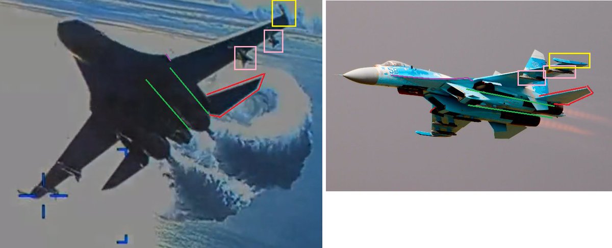
-There was no "contact."-
The propeller is bent in the direction of the flight path of the SU-27.
This kind of damage is ONLY possible if there was a contact.
45/x
The propeller is bent in the direction of the flight path of the SU-27.
This kind of damage is ONLY possible if there was a contact.
45/x

-This is caused by dumping fuel on it.-
An MQ-9 Reaper is build for flying in War zones.
It can handle rain. And water has more density than fuel, like Kerosene.
It's impossible this propeller has this damage from a fuel dump.
nationalguard.mil/News/Article-V…
46/x
An MQ-9 Reaper is build for flying in War zones.
It can handle rain. And water has more density than fuel, like Kerosene.
It's impossible this propeller has this damage from a fuel dump.
nationalguard.mil/News/Article-V…
46/x


-Why did you draw the box there?-
This is based on the line of sight, the angle to the mountains and the assumption that Russia would only response so aggressive to a VS/NATO asset when it has the advantage of being close to it's own AOR.
47/x
This is based on the line of sight, the angle to the mountains and the assumption that Russia would only response so aggressive to a VS/NATO asset when it has the advantage of being close to it's own AOR.
https://twitter.com/GeoConfirmed/status/1636551050780897281
47/x
-It's claimed that it's crashed way closer to Turkey than what is visible on your tweet-
The tweet is based on the footage. So you don't see the drone crashing, so it could be flying indeed elsewhere to crash. Last footage shows flying WSW.
48/x
The tweet is based on the footage. So you don't see the drone crashing, so it could be flying indeed elsewhere to crash. Last footage shows flying WSW.
https://twitter.com/GeoConfirmed/status/1636551050780897281
48/x
-If Russia would this to the US it would be way more aggressive-
Wrong, The Western countries always react professional. And it's known for decades that Russia has a very unprofessional behavior in this matter.
washingtonpost.com/news/checkpoin…
49/x
Wrong, The Western countries always react professional. And it's known for decades that Russia has a very unprofessional behavior in this matter.
washingtonpost.com/news/checkpoin…
49/x


The two pilots are now nominated for state awards for their actions while they violated international law by harassing a US (NATO) MQ-9 Reaper leading to it's crash.
Russia is officially motivating aggression against Western assets based on lies.
tass.com/defense/1590123
50/x
Russia is officially motivating aggression against Western assets based on lies.
tass.com/defense/1590123
50/x

"What happened to the yellow stripes?"
Nothing, you still can see them.
Drone is flying other direction, so the shade is different.
First frames it was flying towards the sun.
Drone in last frames is flying away from the sun. 👇
51/x
Nothing, you still can see them.
Drone is flying other direction, so the shade is different.
First frames it was flying towards the sun.
Drone in last frames is flying away from the sun. 👇
51/x

• • •
Missing some Tweet in this thread? You can try to
force a refresh