It is #IrishHeritageMonth and this is the story of the Irish Famine Immigrants in Toronto!

In 1847, Toronto had a population of 20,000 people but between May and October of that year, it saw the influx of 38,560 Irish immigrants, fleeing the Irish Famine.

🧵1/5
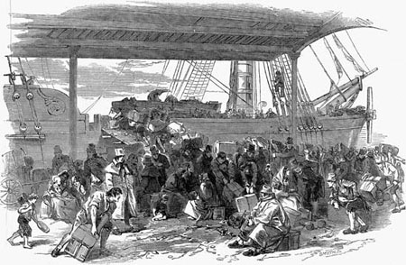
The immigrants had travelled on overcrowded ships across the ocean, with the goal of settling on land in Canada West.
Unfortunately, many were sick with typhus.
Bishop Michael Power tended to the immigrants before he died of typhus on Oct. 1, 1847 at the age of 42.

🧵2/5
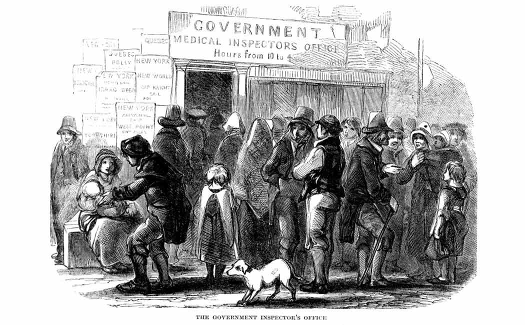
Knowing a huge influx of immigrants was arriving, Toronto created its first board of public health in February 1847.
The board built a dozen sheds for immigrants suffering from typhus, located on the corner of King and John Street.

🧵3/5
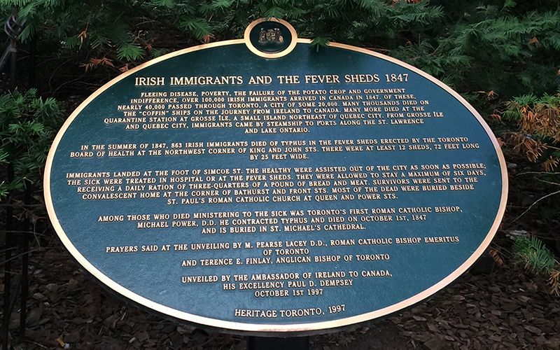
By the end of 1847, 1,186 of the immigrants had died, with 1,100 buried in a mass grave by St. Paul's Basilica at Queen St E. & Power Street.
Despite the influx of people, by 1848 most of the Irish immigrants had moved on beyond Toronto to find family, land & work.

🧵4/5
It is believed only 781 of the Irish Famine immigrants settled in Toronto.
They settled in what became known as Cabbagetown, located near Parliament and Gerrard St. E.
It received that name because the immigrants used their lawns to grow cabbage.

🧵5/5

• • •

Missing some Tweet in this thread? You can try to force a refresh
 

Keep Current with Craig Baird - Canadian History Ehx

Craig Baird - Canadian History Ehx Profile picture

Stay in touch and get notified when new unrolls are available from this author!

Read all threads

This Thread may be Removed Anytime!

PDF

Twitter may remove this content at anytime! Save it as PDF for later use!

Try unrolling a thread yourself!

how to unroll video
  1. Follow @ThreadReaderApp to mention us!

  2. From a Twitter thread mention us with a keyword "unroll"
@threadreaderapp unroll

Practice here first or read more on our help page!

More from @CraigBaird

Mar 16
On this day in 1985, hockey great Eddie Shore died of liver cancer.
He was such a legend that he was name-dropped in Slap Shot. Shore was one of the greatest NHL players ever...and one of the meanest on the ice.
Let's learn more about the Edmonton Express!

🧵1/12 The image is a black-and-white photograph of a person wearing a hockey jersey with the text "Boston Bruins" and the team's bear logo prominently displayed on the front. The jersey features horizontal stripes on the sleeves and body. The background is plain, focusing attention on the person and their attire.
Shore was born in Fort Qu'Appelle and grew up in Cupar, SK. Shore played his first organized hockey with the Cupar Canucks and then the Melville Millionaires.
In 1926, he started his professional career with the Regina Capitals, before playing for the Edmonton Eskimos.

🧵2/12 The image is a black-and-white photograph of a person wearing a vintage hockey jersey with the word "MILLIONAIRES" written on it. The jersey features horizontal stripes, and the person is standing among others, some of whom also wear similar jerseys. The background is plain, focusing on the players and their uniforms.
In 1926-27, he debuted with the Boston Bruins, leading the league in penalty minutes (136 in 41 games) in his first season.
From his very first game, Shore became known for his toughness on the ice and his refusal to back down from anyone, including teammates.

🧵3/12 The image is a black-and-white photograph of a person wearing a hockey jersey with a prominent "B" on the front, likely indicating the Boston Bruins team. The background appears to be an indoor arena with tiered seating. The person's jersey features horizontal stripes, typical of older hockey uniforms.
Read 13 tweets
Mar 16
Before the dynasties, Richard, Beliveau, Lafleur and Roy, the Montreal Canadiens were in trouble.
The team nearly moved to Cleveland, and then nearly folded. But one man helped save them...Conn Smythe.
Let's learn how Montreal almost lost the Canadiens!

🧵1/12 The photo is a black-and-white image of a vintage hockey team, featuring players wearing early 20th-century uniforms with the "CH" logo, indicative of the Montreal Canadiens. The team is posed in two rows, with the front row seated and holding hockey sticks, and the back row standing. The goalkeeper is distinguishable by his larger leg pads and distinct equipment. The background shows a brick wall with large windows, suggesting an indoor or rink setting.
In the early-1930s, the Canadiens were riding high. From 1927-28 to 1931-32, the team finished first four times and won two Stanley Cups.
At the time, the team was stacked with Hall of Famers such as Howie Morenz, Aurèle Joliat, Sylvio Mantha and George Hainsworth.

🧵2/12 This is a black-and-white photograph of Howie Morenz, standing against a textured backdrop, likely a curtain or fabric. The player is dressed in an early 20th-century hockey uniform, which includes a sweater with the "CH" logo, identifying him as a member of the Montreal Canadiens. The sweater has horizontal white stripes on the sleeves and a white band across the chest, with the "CH" prominently centered. He is wearing large, padded hockey gloves and holding a wooden hockey stick in his right hand, with the blade resting on the ground. His shorts are knee-length, and he...
But even The Great Depression could bring down greatness.
It was going to bring an end to several franchises such as the Ottawa Senators and Montreal Maroons, and it nearly did the same to the Montreal Canadiens.
Despite the team doing well, crowd sizes were small.

🧵3/12 The photo is a black-and-white image of an ice hockey game in progress, featuring two players near the goalpost with a goalkeeper defending. The scene is set in an indoor rink with a large crowd seated in the stands, and a referee is visible in the background. The image has a vintage feel, likely from the mid-20th century.
Read 13 tweets
Mar 15
A few days ago, I looked at how the international border through The Great Lakes was determined.
But what about the border west of Lake Superior?
It took decades to determine and wasn't just "drawn with a ruler by some guy".
Let's learn more!

🧵1/13 The photo shows a grassy, open landscape with a clear blue sky dotted with a few wispy clouds. The terrain appears to be a mix of tall, dry grass and patches of dirt, suggesting a rural or prairie setting. A narrow dirt path or road stretches across the scene from left to right, dividing the landscape. In the foreground, there is a vertical marker or signpost standing in the grass. The sign has text on it, with the most prominent words being "UNITED STATES AND CANADA" written vertically in large, bold letters. Below this, there is smaller text, likely providing additional informat...
The 49th parallel border begins west of the Northwest Angle, a blip on the border that gives Minnesota part of the Lake of the Woods.
That 197 sq-km area came about due to treaties and a limited understanding of the geography west of Lake Superior.

🧵2/13 The image is a map highlighting a specific geographical area near the border between the United States and Canada. The map shows parts of Minnesota in the United States and Manitoba and Ontario in Canada. Key locations are labeled, including: Northwest Angle, which is situated in the northern part of Minnesota, extending into a body of water.  Elm Point, located slightly to the southwest of Northwest Angle, near the border.  Muskeg Bay, positioned near Elm Point.  Lake of the Woods, a large lake that dominates the central part of the map, with Northwest Angle protruding into it.
The 49th parallel border runs from the Strait of Georgia in the west to the Lake of the Woods.
It extends for 2,030 kilometres.
Having this as a border was first proposed before the United States even existed, back in 1714 by the Hudson's Bay Company.

🧵3/13 The image is a map of a portion of North America, focusing on the border region between the United States and Canada. The map highlights the 49th parallel, which is marked with a red dashed line running horizontally across the map. This parallel serves as a significant portion of the border between the two countries. Key features on the map include: Point Roberts, located on the far western side of the map, just south of the 49th parallel. It is a small exclave of the United States, surrounded by water and Canadian territory, accessible by land only through Canada.  Lake of the Woods, situa...
Read 14 tweets
Mar 12
From 1973 to 2022, Canada and Denmark were at war.
Over the course of the war, several soldiers on both sides were wounded....by hangovers. And it was all fought over a tiny island the size of a city block.
Let's learn about The Whisky War!

🧵1/16 The photo shows two side-by-side images. The left image depicts a group of people in military-style camouflage uniforms raising a Canadian flag on a pole surrounded by rocks, with a helicopter in the background. The right image shows a group of individuals, some in red uniforms and one in a dark coat, standing in front of a Danish flag on a pole, with a frozen landscape and mountains in the background.
Hans Island is a tiny island, 1.3 square kilometres in size, located between Ellesmere Island and Greenland.
It has no trees, no grass and is not inhabited.
The island is in the territory of the Inuit, who have visited it periodically over the centuries.

🧵2/16 The image is a map showing a portion of the Arctic region, specifically focusing on the area between Canada and Greenland. The map highlights two islands: Ellesmere Island, which is part of Canada, and Hans Island, located between Ellesmere Island and Greenland. Ellesmere Island is labeled and marked with a black dot, while Hans Island is marked with a small circle and labeled in blue. The map also includes a small inset in the top right corner showing the broader Arctic region, with a dot indicating the location of this area within the Arctic Circle. The map is sourced from the BBC, as ind...
The first-known Europeans reached the island in 1853 when a Danish expedition arrived. The island was named for an Inuk man on the expedition Hans Hendrik. He saved several men on the expedition when they journeyed too far from the ship on the ice.

🧵3/16 The image is a black-and-white illustration of a person wearing a fur hat and a heavy coat with a high collar, suitable for cold weather. The style suggests an older, possibly historical depiction, with detailed cross-hatching for shading.
Read 17 tweets
Mar 11
The Great Lakes hold 23 quadrillion litres of water and 20% of the world's fresh surface water supply.
But how did Canada and the USA determine the border between the Great Lakes and also agree on the use of the lakes?
Let's learn about the treaties!

🧵1/10 The photo is a satellite image of the Great Lakes region in North America. It prominently features the five Great Lakes—Superior, Michigan, Huron, Erie, and Ontario—surrounded by lush green landmasses, including parts of the United States and Canada. The image shows varying shades of blue in the lakes, with some cloud cover scattered across the land.
When the Treaty of Paris of 1783 ended the American Revolutionary War, the treaty set out the boundary between the USA and British North America.
That border went through the Great Lakes but it was not officially surveyed.

🧵2/10 The photo shows a historical document, specifically a page from the Treaty of Paris. The text is written in an elegant, cursive script typical of the 18th century. The document states that it was "Done at Paris the third day of September in the year of our Lord one thousand seven hundred and eighty-three" and is signed by notable figures, including "John Adams," "B Franklin" (Benjamin Franklin), and "John Jay." The page is adorned with several red wax seals attached with ribbons, signifying its official nature and authenticity. The parchment appears a...
The Rush-Bagot Treaty of 1818 limited naval armaments on the Great Lakes. This treaty was significant as it laid the groundwork for a demilitarized border between the USA and Canada and the longest demilitarized border in the world (8,891 km).

🧵3/10 The photo depicts an old map titled "A Map of the Frontier Lakes with part of Pennsylvania, New York, Canada, and the Hudson Bay Territories." The map appears to be historical, likely from the 18th century, given its style and the date "1783" printed in the bottom right corner. It focuses on the Great Lakes region, showing Lake Huron, Lake Erie, Lake Ontario, and parts of Lake Michigan and Lake Superior, labeled as they were known at the time (e.g., "Lake Hurons"). Surrounding areas are labeled as "Canada," "Ohio," "Pennsylvania," ...
Read 11 tweets
Mar 8
On this day in 1919, Bob Homme was born.
While he was born in the United States, he adopted Canada as his home. To generations of Canadians, he was The Friendly Giant.
Let's look up...waaaaay up...and learn about his life!

🧵1/12 The photo features an older man with white hair, smiling at the camera. He is dressed in a rustic, medieval-style outfit, including a tan tunic with a brown collar and black pants. In his hands, he holds a violin and a small stringed instrument, possibly a dulcimer or zither, placed on his lap. Over his shoulder, he carries a bagpipe.  Accompanying him are two puppet-like figures: one is a colorful giraffe with blue spots and a harmonica in its mouth, positioned to his left, and the other is a chicken puppet perched on his right shoulder, dressed in a polka-dotted outfit. The background is ...
Bob Homme was born in Stoughton, Wisconsin where his parents were teachers at the high school.
After he graduated from school, he attended the University of Wisconsin and graduated with a degree in economics.
He joined the Air National Guard in 1939.

🧵2/12 This black-and-white photo depicts a man with short hair, smiling at the camera. He is dressed in a medieval or folk-style outfit, featuring a loose-fitting tunic with a belt around his waist. He appears to be playing a set of bagpipes, with one hand on the chanter and the other supporting the bag, which is decorated with a polka-dot pattern.  Behind him stands a puppet resembling a giraffe with large spots, holding a violin and bow, as if playing along. The background consists of a stone wall with a rounded, textured pattern, giving the scene a rustic or historical ambiance. The overall co...
When Japan attacked Pearl Harbor, his unit was activated. He was promoted to Staff Sergeant and was assigned to study psychology at Cornell. He ended his time in the Second World War classifying and discharging servicemen who were returning home.

🧵3/12 This black-and-white photo shows a man kneeling or crouching on a wooden platform. He is dressed in a rustic, medieval-style outfit, featuring a loose-fitting tunic with frayed edges and dark pants. His hands are positioned as if he is adjusting or placing a small object, possibly a miniature accessory, onto a detailed model of a barn with a pitched roof and a small cupola. The background includes a painted scene depicting a rural landscape with a windmill, trees, and rolling hills, suggesting a farm setting. The indoor setting is hinted at by the visible pipes and conical structures above,...
Read 13 tweets

Did Thread Reader help you today?

Support us! We are indie developers!


This site is made by just two indie developers on a laptop doing marketing, support and development! Read more about the story.

Become a Premium Member ($3/month or $30/year) and get exclusive features!

Become Premium

Don't want to be a Premium member but still want to support us?

Make a small donation by buying us coffee ($5) or help with server cost ($10)

Donate via Paypal

Or Donate anonymously using crypto!

Ethereum

0xfe58350B80634f60Fa6Dc149a72b4DFbc17D341E copy

Bitcoin

3ATGMxNzCUFzxpMCHL5sWSt4DVtS8UqXpi copy

Thank you for your support!

Follow Us!

:(