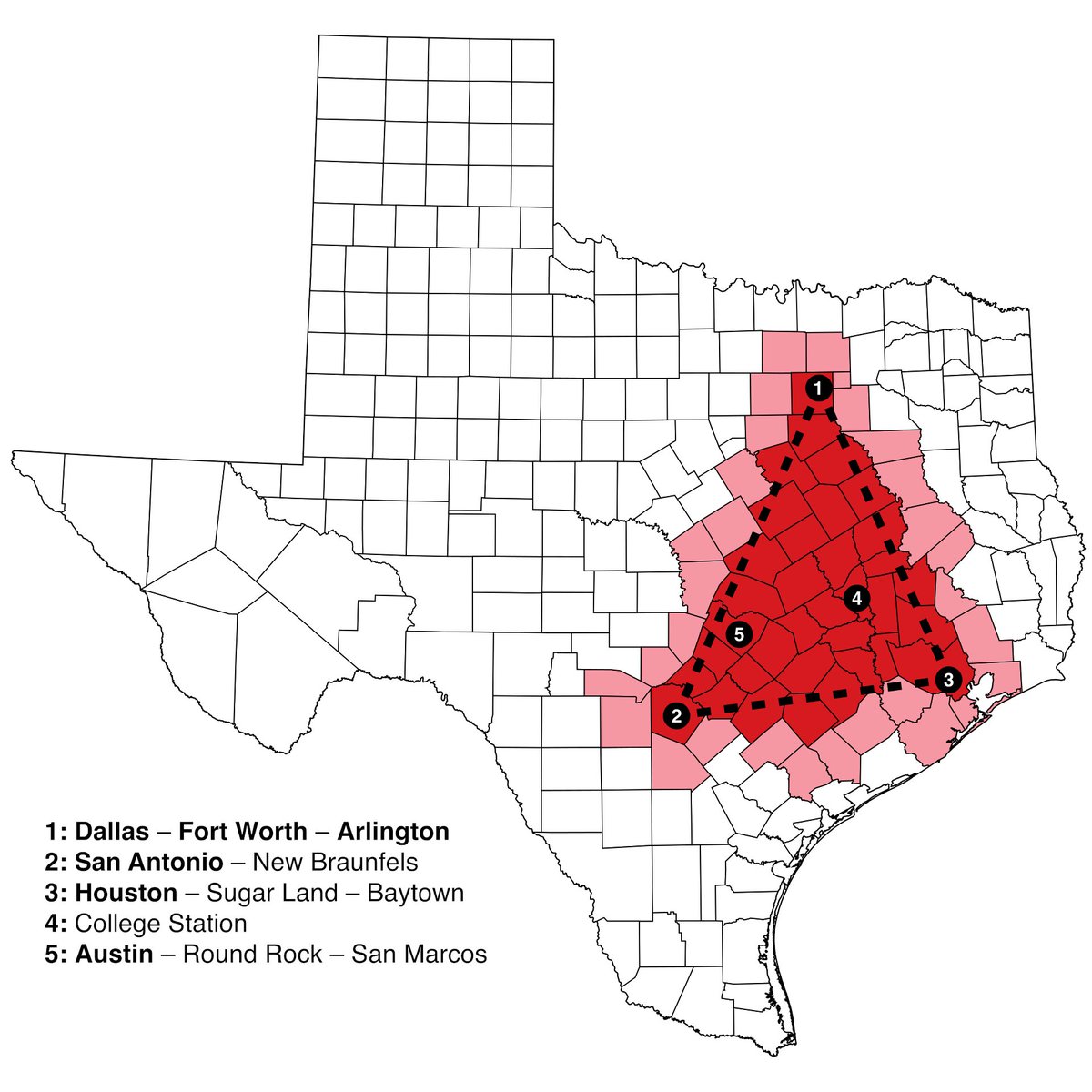
The Texas Triangle , between Houston, Dallas, and San Antonio, contains 75% of Texans.
Why?
What's special about that triangle?
Why?
What's special about that triangle?
A map of night lights shows that ppl are concentrated in its tips and edge:
• One of its tips is the massive Houston
• Another tip is an uncommon type of city: the couple Dallas–Fort Worth
• Then there's a line of cities between Dallas and San Antonio w/ Austin, Waco...
Why?
• One of its tips is the massive Houston
• Another tip is an uncommon type of city: the couple Dallas–Fort Worth
• Then there's a line of cities between Dallas and San Antonio w/ Austin, Waco...
Why?

What can the satellite tell us?
If you look carefully, you can see a green and grey line running from San Antonio to Dallas. What is it?
If you look carefully, you can see a green and grey line running from San Antonio to Dallas. What is it?

The topography can give is a clue: the mountains drop in altitude on a line from San Antonio to Dallas! This fall line transforms the mountains into hills that can be crossed

Sure enough, many of the most important Texan cities are on the fall line of the Edwards Plateau. These form the grey line on the satellite picture.
But why did these cities emerge at these points on that line, and not others?
But why did these cities emerge at these points on that line, and not others?

They're each at the crossing between that fall line and a river:
• San Antonio: San Antonio River
• Austin: Colorado River
• Waco: Brazos River
• Fort Worth and Dallas: Trinity River
This is the same as on the Atlantic Seaboard
• San Antonio: San Antonio River
• Austin: Colorado River
• Waco: Brazos River
• Fort Worth and Dallas: Trinity River
This is the same as on the Atlantic Seaboard

And like on the Atlantic Seaboard, there's a road connecting all these Texan cities: the interstate 35.
The enduring value of this route is revealed in its ancient origins, as this very path is probably the same as the ancient Chisholm Cattle Trail
We'll get back to it
The enduring value of this route is revealed in its ancient origins, as this very path is probably the same as the ancient Chisholm Cattle Trail
We'll get back to it

The pbm with these rivers is that they're not very navigable. They did bring water and irrigation to their cities—hence why they appeared there—but their transportation utility was limited. Which is why Texas pushed hard to develop its railroads.

The end of the 19th century saw both a huge construction of railroads and the discovery of oil. Both of these finally started the growth of the Texan population
So that's why one edge of the Texas Triangle is so populated. But why is the other tip in Houston? Why not anywhere else on the coast? There are plenty of other successful ports in Texas, even to this day

Normally, you just have one big port per region, because there's benefits in having all the goods go to the same hub.
And natural bays tend to be the place where they emerge, protected from the ocean. But there are several bays in Texas. Why did Houston's bay win?
And natural bays tend to be the place where they emerge, protected from the ocean. But there are several bays in Texas. Why did Houston's bay win?

It didn't
In the 1800s, Houston was not the biggest port in Texas. It was Galveston, established by the Mexicans in 1825
Galveston grew because of its position:
• Great bay
• Close to N Orleans
• As close as possible to the other main TX cities: San Antonio, Dallas, Austin..
In the 1800s, Houston was not the biggest port in Texas. It was Galveston, established by the Mexicans in 1825
Galveston grew because of its position:
• Great bay
• Close to N Orleans
• As close as possible to the other main TX cities: San Antonio, Dallas, Austin..

And then in 1900, Galveston learned a lesson that other regions had learned through centuries of storms: Galveston was too close to the sea.
It suffered a hurricane that devastated it. The port and industries moved as inland as they could.
That was Houston.
It suffered a hurricane that devastated it. The port and industries moved as inland as they could.
That was Houston.

Houston was at the confluence of two navigable bayous, had invested in improving their navigability, and had received one of the earliest railroads on their way to Galveston. It had all the infra it needed and was close to Galveston. Perfect heir.
Hard for other ports to compete
Hard for other ports to compete

So that's why 75% of Texans live in the Triangle:
1. End of the Edwards Plateau
➡️easier transportation
➡️rivers form
➡️great spot for cities, which follow the fall line: San Antonio, Austin, Waco, Killeen, Fort Worth, Dallas
2. Houston, heir to well-located Galveston
1. End of the Edwards Plateau
➡️easier transportation
➡️rivers form
➡️great spot for cities, which follow the fall line: San Antonio, Austin, Waco, Killeen, Fort Worth, Dallas
2. Houston, heir to well-located Galveston

I write threads like this once a week. Here, on California. Follow for more
I'll write soon about why New York is the biggest city on the Atlantic coast.
I'll write soon about why New York is the biggest city on the Atlantic coast.
https://twitter.com/tomaspueyo/status/1641853715354091532?s=20
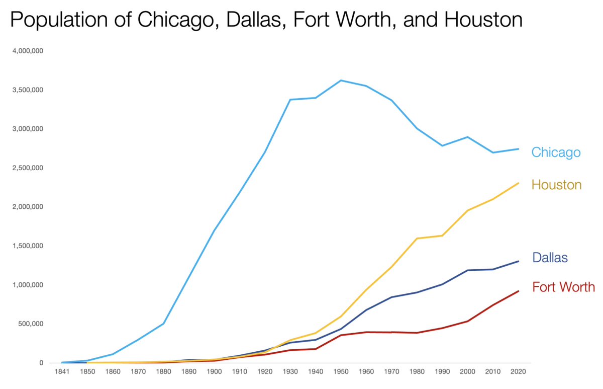
This doesn't explain why Dallas and Fort Worth are so close to each other. I'll write about this in my upcoming article on this.
And maybe about other cities: Pittsburgh, Minneapolis–St Paul, Kansas City.. Sign up to my free newsletter to receive it
unchartedterritories.tomaspueyo.com/subscribe
And maybe about other cities: Pittsburgh, Minneapolis–St Paul, Kansas City.. Sign up to my free newsletter to receive it
unchartedterritories.tomaspueyo.com/subscribe
Some of you mention rainfall. True: there's more rain east of the line—because altitude is lower! We can see the line in the precipitation maps of spring: a rain line passes through the fall line (left)
But it disappears during late summer rainfall times (right)
But it disappears during late summer rainfall times (right)


• • •
Missing some Tweet in this thread? You can try to
force a refresh