David Helms Profile picture
May 7, 2023 7 tweets 4 min read Read on X
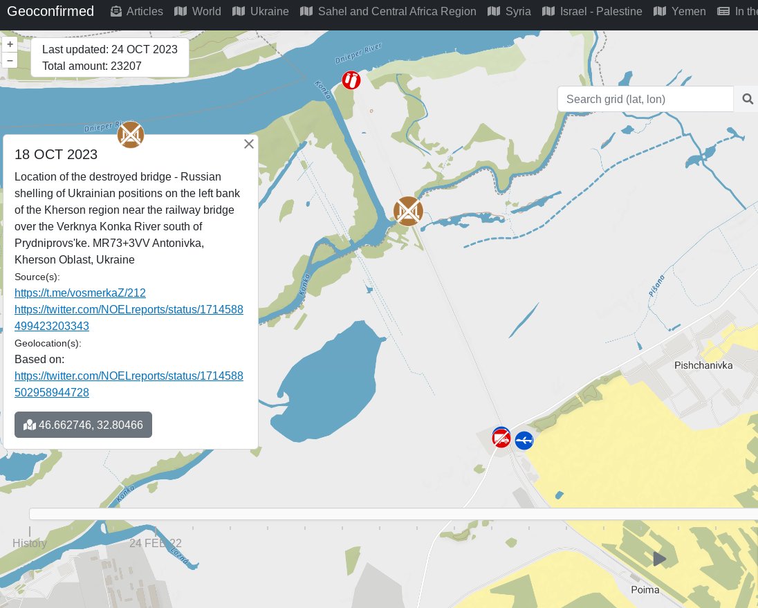
1. Ruschist operation of Kakhovka HPP (K-HPP) dam has been reckless. Kakhovka Reservoir (KR) water level has alternated from record low to record high in just 3 months. Loop (6 FEB-6 MAY 2023) shows sand bars receding with rising KR water. #NAFOWeather🧵
2. These images are of the K-HPP from Left: 6 FEB, and Right: 6 MAY 2023 (enhanced from data included in loop). ImageImage
3. North Crimean Canal intake, Left 20 FEB 2023 Right 6 May 2023: Latest image show water gushing through NCC intake gate at Tavrisk as record KR level is pushing water through gravity fed NCC at high rates. ImageImage
4. Zaporizhzhia Nuclear Power (Z-NPP) Plant: More retreating sand bars west and north of Z-NPP cooling pond and "sprayer" canals. Left: 5 MAR 2023 Right: 6 MAY 2023 ImageImage
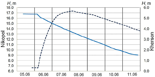
5. North KR Islands towards Dnipro. Sand bars have disappeared once again as KR water level rapidly increased at record pace from 14.0 meters to 17.0 meters in 3 months. Left: 2 MAR 2023 Right: 6 MAR 2023 ImageImage
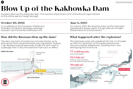
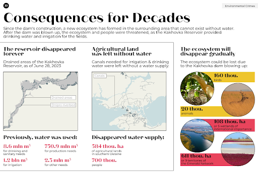
6. Kakhovka Reservoir contains over 18 cubic kilometers of water, 46% of all water storage in the Dnipro cascade. Ruschist incompetence and/or intentional mismanagement continues to put thousands of Ukrainian civilians at risk. end/ Image
@threadreaderapp please unroll

• • •

Missing some Tweet in this thread? You can try to force a refresh
 

Keep Current with David Helms

David Helms Profile picture

Stay in touch and get notified when new unrolls are available from this author!

Read all threads

This Thread may be Removed Anytime!

PDF

Twitter may remove this content at anytime! Save it as PDF for later use!

Try unrolling a thread yourself!

how to unroll video
  1. Follow @ThreadReaderApp to mention us!

  2. From a Twitter thread mention us with a keyword "unroll"
@threadreaderapp unroll

Practice here first or read more on our help page!

More from @davidhelms570

Jan 15
1/ Update on river ice conditions on the lower Dnipro near UAF left bank beachhead. Average temperatures in the south have fallen below 0C since 8 JAN, much below 0C after 11 JAN lowering water temps to near 0C and starting river ice growth. Image
2/ Most recent visible imagery: Sentinel-2 (9 JAN) shows dark water indicating unfrozen water w/ no snow cover. LANDSAT8 (11 JAN) shows ice formation in the larger lakes between the Antonovsky Bridges. Ice is definitely forming on the Konka River but not yet on the Dnipro River.
Image
Image
3/ Sentinel-1 SAR timeseries:
11 JAN: Rough surface ( speckled gray) on Dnipro indicates wind waves on open water
15 JAN: Dark surface with white ridges on Dnipro RIver shows new ice (nilas, 5-10 cm thick); Konka river definitely frozen.
Read 6 tweets
Nov 19, 2023
On 8 NOV 2023, a RF missile struck a Liberian registered commercial ship in Odesa region port. This #NAFOWeather🧵examines why the ship was in Ukrainian port, initial findings on RF weapon used, subsequent data available to confirm initial findings & impact to #UkriCor transits.
2/ Prior to the 24 FEB 2022 full-scale RF invasion, Ukraine exported enough grain to feed 400 million people, most in the famine probe Global South.
topleadprojects.com/environmental-…
Image
3/ Since 24 FEB 2022, RF has systematically attacked Ukraine's ag infrastructure, blockaged ports & seized grain in occupied areas w/ the goal of weaponizing grain to pay for its war effort, hurt Ukraine's economy & deny food to Ukraine's export partners.

Image
Read 23 tweets
Oct 25, 2023
1/ There has been daily reports of clashes near the Antonovsky Rail Bridge crossing of the Dnipro river between Prydniprovs'ke and Poima since 18 October 2023. A #NAFOWeather🧵on the Dnipro wetland ground conditions supporting offensive operations.
Image
2/ First, key dates in this region: Important to note that RF used this location to ferry troops and vehicles in the fall 2022 and UAF has been been attacking RF obn the left bank near the Antonovsky Bridge 6 km downstream of this location in late June 2023. Image
3/ The Dnipro river delta wetlands is about 3.9 km wide at the Antonovsky Rail Bridge crossing. The crossing includes two bridges, 0.5 km bridge (destroyed) over the Dnipro main channel and a 40 meter bridge (destroyed) over the Verkhnya Konka River. Image
Read 16 tweets
Oct 15, 2023
1/ Fall 2023 #MudSeason “bezdorizhzhia (ukr.)/rasputiza" prediction. 15 OCT 2023 Update (version 1!), a #NAFOWeather 🧵
2/ BLUF: Fall 2023 #MudSeason onset will likely be delayed a month due to lower rainfall over east & south Ukraine from AUG thru early OCT 2023. The result of rainfall deficit, along with clear skies & lower humidity increased evaporation caused lower soil moisture than normal. Image
3/ Background: This prediction uses NATO Reference Mobility Model (NRMM) derived correlation between soil moisture and soil strength. While NRMM uses multiple land surface features to develop maximum speed predictions, the most time-variant feature is soil moisture. Image
Read 14 tweets
Sep 22, 2023
1/ On 17 JUL, Ukrainian #USVs damaged the Kerch vehicle bridge near Tuzla Island. On 3 AUG, Tanker SIG was severely damaged by a #USV while at anchor south of the Kerch bridge. In addition to sinking barges (see below), what has RF done to protect Kerch shipping? A #NAFOWeather🧵
2/ Pictures are today's ship position (mostly at anchor south of the Kerch bridge), the right picture includes the ship track heat map from 2022. Ships that anchored west of Port Taman in 2022 are now gone.
What happened?
Image
Image
3/ Sentinel 2 True Color loop shows northern most anchorage clearing out between 21 AUG and 10 SEP.
Read 15 tweets
Sep 10, 2023
1/ It has been 3 months since the Russians blew-up the Kakhovka HPP dam on 6 June 2023. What is happening to the Dnipro River hydrology and ecology? What are are the options for rebuilding the HPP and possibility for a Dnipro left-bank beachhead? A #NAFOWeather 🧵
Outline: Image
2/ K-HPP Destruction Impacts:
- Irrigation/agricultural land lost: 350,000-550,000 ha
- Drinking (population 700,000) and industrial water loss
- Zaporizhzhia NPP cooling pond water supply loss
- 14,000 homes flooded, many drowned

topleadprojects.com/environmental-…
theguardian.com/world/2023/jun…

Image
Image
3/ 6-11 June Water Level Changes: Nikopol (left y-axis) and Kherson City (right y-axis) from Vyshnevskyi, et al, 2023
Immediately after the Russians blew up the K-HPP dam, the Kakhovka Reservoir water level began lowering and within 6 hours, the Kherson City water level increased Image
Read 50 tweets

Did Thread Reader help you today?

Support us! We are indie developers!


This site is made by just two indie developers on a laptop doing marketing, support and development! Read more about the story.

Become a Premium Member ($3/month or $30/year) and get exclusive features!

Become Premium

Don't want to be a Premium member but still want to support us?

Make a small donation by buying us coffee ($5) or help with server cost ($10)

Donate via Paypal

Or Donate anonymously using crypto!

Ethereum

0xfe58350B80634f60Fa6Dc149a72b4DFbc17D341E copy

Bitcoin

3ATGMxNzCUFzxpMCHL5sWSt4DVtS8UqXpi copy

Thank you for your support!

Follow Us!

:(