Forensic Architecture Profile picture
May 24, 2023 9 tweets 8 min read Read on X
This week at #UNAHanau @mimueller/@cdu_hessen said our work on the police response to the 19-Feb-20 racist attack was ‘fully without worth’, & called us ‘charlatans’. Maybe he wasn’t paying attention; here’s a few things the UNA knows because of our work:

forensic-architecture.org/investigation/…
It was @ForensicArchi + @counterinv who proved that the video camera on the police helicopter which was flying over Hanau that night was set to the wrong time. Maybe @mimueller doesn’t think it’s important that #UNAHanau knows precisely what time the events of the night happened.
We also showed that officers watching the perpetrator’s front door weren’t in position by 23h03 & left again at 23h21. Even though the officers said they were there around 22h30-45. Maybe @mimueller doesn’t think it’s important that the house went unsurveilled for so long.
We also showed that as late as midnight, there was no secure perimeter around the house; civilians could still walk past the perpetrator’s car. Maybe @mimueller doesn’t think it’s important that civilians could get so close to the house of a dangerous and violent extremist.
We revealed that the leaders of the police operation never communicated with the helicopter; in the #UNAHanau a heli pilot confirmed this. Maybe @mimueller thinks it’s a good use of resources for a helicopter to fly around without instructions after a terror attack.
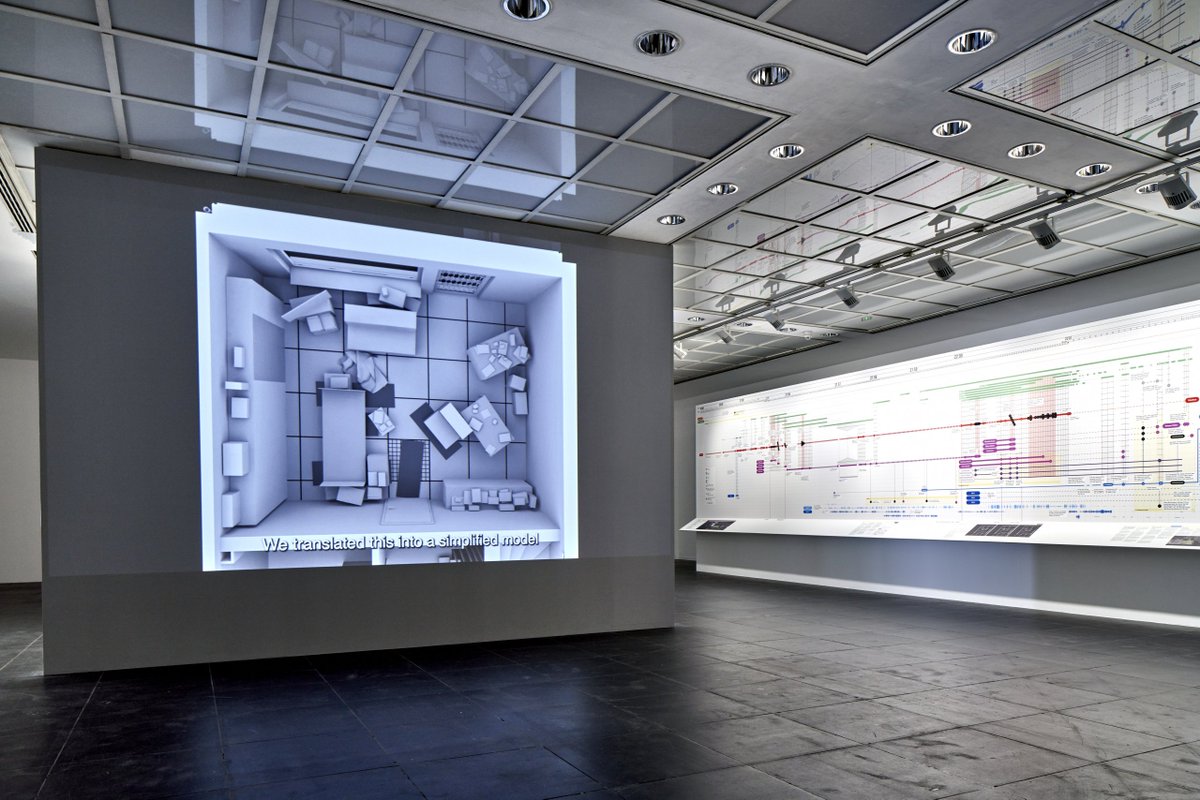
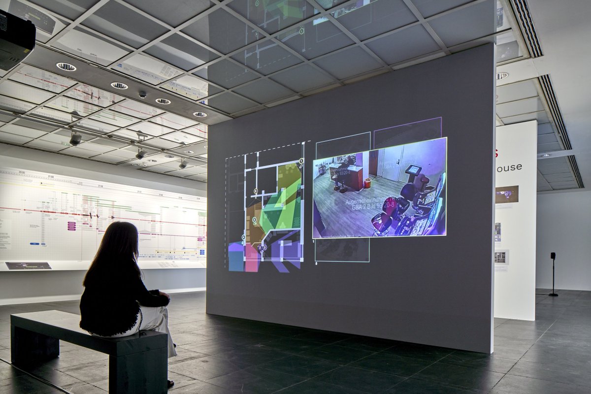
Let’s not forget, the #UNAHanau didn’t even have the heli footage before we exhibited it at @FrankfurterKV in 2022. Some of the UNA committee came to the show, but we didn’t see @mimueller there. Maybe he didn’t think it was important.

sueddeutsche.de/politik/hanau-…
At least @mimueller’s boss, Minister President @Boris_Rhein, thought our investigation was worth studying, in #Hanau earlier this year. Federal Interior Minister @NancyFaeser too. ImageImage
If you think a deeper understanding of how the Hessen police responded to the 19 Feb 2020 racist terror attack is important, you can see more on our findings, and our full investigation (which we weren’t allowed to show in the UNA), here:

...and look out for more dates for Three Doors, our exhibition with the Initiatives @19FebHanau and @OuryJalloh, coming in 2024, where we’ll respond to the final report of the UNA.

(pics: Norbert Miguletz) ImageImageImageImage

• • •

Missing some Tweet in this thread? You can try to force a refresh
 

Keep Current with Forensic Architecture

Forensic Architecture Profile picture

Stay in touch and get notified when new unrolls are available from this author!

Read all threads

This Thread may be Removed Anytime!

PDF

Twitter may remove this content at anytime! Save it as PDF for later use!

Try unrolling a thread yourself!

how to unroll video
  1. Follow @ThreadReaderApp to mention us!

  2. From a Twitter thread mention us with a keyword "unroll"
@threadreaderapp unroll

Practice here first or read more on our help page!

More from @ForensicArchi

Jun 14
NEW: Salman Abu Sitta is a Nakba survivor and historian of Palestine. Together, we digitally reconstructed his birthplace, the village of al-Ma’in, exploring its history and documenting how, in 1948, the village was destroyed and its people forcibly expelled: forensic-architecture.org/investigation/…
On 14 May 1948, al-Ma’in was occupied and demolished by Zionist forces. Image
We reconstructed the village to uncover its layered history — from its vibrant agricultural life, with a 95-metre deep well and a bayarah, to the 60,000 dunams (15,000 acres) of land cultivated by the Abu Sitta family, mostly wheat and barley.
Read 6 tweets
Jun 6
FA has documented a pattern of Israeli attacks on areas into which they have previously instructed civilians in Gaza to evacuate. Our research confirms that the Israeli military carried out multiple attacks in areas towards which civilians had been directed, either on the same day as the evacuation order, or on the day after. See more: frames.forensic-architecture.org/gaza/updates/a…
1) On the morning of 23 Mar 2025, the Israeli military issued an evacuation order for Tel al-Sultan neighbourhood of Rafah, directing civilians to move northeast. That evening, there was an airstrike northeast of Tel al-Sultan, in Khan Younis, that hit the Nasser Medical Complex, the largest hospital in the area.Image
2) On the morning of 7 Apr 2025, the Israeli military issued an evacuation order to Deir al-Balah, directing civilians to move southwest. Later that day, there was an attack on a residential building southwest of Deir al-Balah. The following day, there were two attacks in areas southwest of Deir al-Balah.
Read 6 tweets
Jun 6
Israel has designated the majority of the Gaza Strip for evacuation. 34 evacuation orders have been issued to civilians in Gaza since the dissolution of the ceasefire on 18 March 2025. Many of these orders define differing boundaries for the militarised buffer zone in the east of Gaza, gradually expanding the area designated for evacuation. See more: frames.forensic-architecture.org/gaza/updates/i…
We have documented 4 instances where the declared boundaries of the buffer zone have subsumed areas previously subject to evacuation orders. As of 3 June 2025, the buffer zone has expanded to encompass the municipality of Rafah, as well as areas to the east of Khan Younis and in the north of Gaza.
For example, an evacuation order was issued to the municipality of Rafah on 31 March and 1 April. In an evacuation order issued on 6 April, the declared buffer zone expanded to encompass the areas previously designated for evacuation.
Read 4 tweets
May 16
Israel is constructing a second militarised ‘corridor’ in Gaza, to expand their control of the Strip. Plans for the Morag Corridor were announced on 2 April; since that time, we’ve identified widespread destruction throughout the remains of Rafah city, and several new Israeli military outposts. Follow this developing situation in our new mapping portal: frames.forensic-architecture.org/gaza/updates/m…
A comparison of satellite imagery from 3 April and 11 May reveals how entire areas of central Rafah have been destroyed by the Israeli military.
During the same timeframe, the Israeli military destroyed dozens of buildings and greenhouses, as well as agricultural land, to the north of Rafah, to make way for the construction of the Morag Corridor.
Read 7 tweets
Mar 10
At the summit last week on 4 March, a new plan for Gaza’s reconstruction was presented by Arab leaders as an alternative to Trump’s plan to expel Palestinians from Gaza. Our analysis indicates that this initiative—which has gained support from the European Council—includes an architectural master plan that carries forward key elements of Israel’s designed destruction of Gaza (as addressed in our Cartography of Genocide report bit.ly/cartography-of…), with its proposal for a ‘buffer zone’, security corridors, and raid routes.
The Egyptian master plan consists of three parts.

1. Buffer Zone: Since October 2023, Israel has destroyed all structures within 1,000-1,500 metres of the Gaza perimeter fence and targeted Palestinians who entered this zone. The Egyptian plan integrates the buffer zone into its design and effectively endorses the erasure of multiple historically and politically significant Palestinian neighbourhoods, including Jabalia and Shuja’iyya, by rezoning them for agricultural, investment, and industrial purposes.Image
2. Security corridors: Since October 2023, Israel constructed a six-kilometre-wide impenetrable barrier along Wadi Gaza and expanded the buffer zone along the border with Egypt. The Egyptian master plan incorporates this de facto reality.Image
Read 5 tweets
Oct 29, 2024
NEW: ‘A Cartography of Genocide’. Since October 2023, we have collected and analysed data related to Israel’s military campaign in Gaza. Our findings indicate that Israel has systematically targeted all aspects of civilian life. tinyurl.com/bdcrnzka
We present our findings in a report and an interactive platform, revealing how Israel’s military campaign has fundamentally reshaped Gaza. Much of this reshaping appears to embody in practice the statements of genocidal intent made by Israeli state and army officials and media. We found:
Israel has imposed a new system of spatial control on Gaza, destroying agricultural lands and buildings to create infrastructure that supports a long-term military presence, including roads, checkpoints and a 1 km-wide buffer zone.
Read 10 tweets

Did Thread Reader help you today?

Support us! We are indie developers!


This site is made by just two indie developers on a laptop doing marketing, support and development! Read more about the story.

Become a Premium Member ($3/month or $30/year) and get exclusive features!

Become Premium

Don't want to be a Premium member but still want to support us?

Make a small donation by buying us coffee ($5) or help with server cost ($10)

Donate via Paypal

Or Donate anonymously using crypto!

Ethereum

0xfe58350B80634f60Fa6Dc149a72b4DFbc17D341E copy

Bitcoin

3ATGMxNzCUFzxpMCHL5sWSt4DVtS8UqXpi copy

Thank you for your support!

Follow Us!

:(