THE KAKHOVKA DAM🇺🇦
As more information becomes available on the #KakhovkaDam collapse, it will be important to understand how the structure worked.🏗️
In this thread I'll explore the barrage and power plant through section drawings, before moving on to a discussion of damage. 🧵
As more information becomes available on the #KakhovkaDam collapse, it will be important to understand how the structure worked.🏗️
In this thread I'll explore the barrage and power plant through section drawings, before moving on to a discussion of damage. 🧵
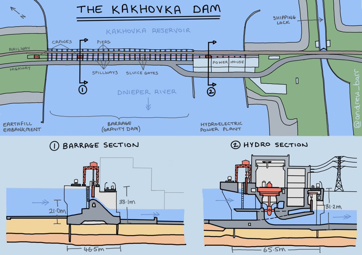
The "dam" is really several structures working together to create the Kakhovka Reservoir: a long earth-filled embankment dam, a central concrete barrage to control water flow, and a hydroelectric plant for power generation.

The BARRAGE is a concrete gravity dam with crane-operated sluice gates to control the water level in the reservoir and the Dnieper River below for shipping and irrigation, and to maintain a head of water for power generation. Road and railway bridges are supported by the piers.

Steel sluice gates are supported by channels in the concrete piers, both of which are strong enough to support the water loading from a full reservoir.

The concrete gravity dam is held in place by its massive self-weight. Concrete aprons above and below the dam, breakwaters, sheet piles and internal drainage all ensure that water uplift does not lead to a sliding or overturning failure.

The HYDROELECTIC POWER PLANT is built in to the barrage, and generates electricity by using the head of water to spin large turbines. These can also be bypassed using additional spillways and control gates.

Water flow through the turbines is controlled by wicket gates, and the spinning turbines are connected by shafts to generators. Transformers and other electrical equipment are used to transmit the resulting electrical power into the grid.

Much of this is hidden under the waterline inside a huge reinforced concrete structure. Only the tops of the generators are visible in the turbine hall on top of the dam. The shorter adjoining structure contains the electrical equipment.

As with the barrage, this section of the dam is fitted with concrete aprons and sheet piles to protect the foundations from water ingress.

I've used the present tense so far, but of course much of what I've shown you has now been destroyed. In Part 2 of this thread I'll look at what we know based on satellite images and videos so far.

THE KAKHOVKA DAM 🇺🇦
Thread part 2: Damage assessment 🧵
On 6th June 2023 the #KakhovkaDam was breached, causing catastrophic flooding as the Kakhovka Reservoir rapidly drained. Now that we know how the dam worked, we can assess what's currently known about the damaged caused.
Thread part 2: Damage assessment 🧵
On 6th June 2023 the #KakhovkaDam was breached, causing catastrophic flooding as the Kakhovka Reservoir rapidly drained. Now that we know how the dam worked, we can assess what's currently known about the damaged caused.
(Read from the start of the thread above for more information on the construction and function of the barrage dam and hydroelectric power plant. ☝️)


Existing damage: The dam has come under attack several times already since Russia invaded Ukraine in February 2022.
Both the road and rail bridges are damaged in this satellite image from 28th May, which also shows the very high water level in the dam.
Both the road and rail bridges are damaged in this satellite image from 28th May, which also shows the very high water level in the dam.

In the days leading up to the dam breach a further section of the road bridge was destroyed, along with parts of the piers which supported them.
It's worth noting that the road and railway aren't structurally part of the dam, but simply make use of the same pier supports.
It's worth noting that the road and railway aren't structurally part of the dam, but simply make use of the same pier supports.

It's also worth stressing that water overtopping the sluice gates would not be expected to cause a failure of the barrage.
Engineers carefully consider the highest loads a structure can be expected to carry during its lifetime, and then apply safety factors on top of this.
Engineers carefully consider the highest loads a structure can be expected to carry during its lifetime, and then apply safety factors on top of this.
On 6th June the Barrage (1), Hydroelectric Power Plant (2) and Earth-filled Embankment (3) were all breached, in that order. We'll consider them in turn.
In this image, note how the size of the opening mobilises a huge volume of water, compared to the localised flow on 5th June.
In this image, note how the size of the opening mobilises a huge volume of water, compared to the localised flow on 5th June.

1) The BARRAGE appears to have been damaged first, as shown in this early footage, where the HPP is still intact. So the big question, is this just a structural failure or the result of an explosion? 💥
We'll not be certain about anything until we can see the damage that's currently hidden under the water, but the scale of the damage to many sturdy piers is unlikely to have resulted from overtopping.
This structure is designed for the continuous flow of water through it, so even the loss of several sluice gates should not lead to the progressive collapse of piers. Existing damage in this area of the dam also appears to be superficial.
I think it's much more likely that explosives have been used to intentionally destroy a number of piers and gates at once.
The energy required to do this is far beyond what could be achieved with guided munitions - explosives would have to be placed on or inside the structure.
The energy required to do this is far beyond what could be achieved with guided munitions - explosives would have to be placed on or inside the structure.
Of course, Ukraine claimed back in October that the Russians had done just this. bbc.co.uk/news/world-eur…
A successful demolition of the barrage could likely be achieved by placing explosives near the base of the piers, or if you had control of the structure, inside the drainage galleries that run inside the crest of the gravity dam section.

Drainage galleries are long tunnels that are used to collect and drain off any water that seeps into the foundation or upstream face of the dam - this prevents the uplift pressure from this water destabilising the structure.

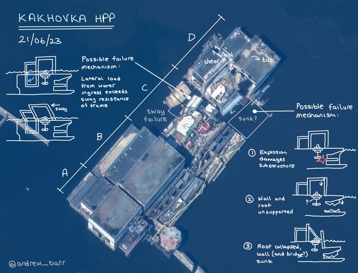
2) The HYDROELECTRIC POWER PLANT appears to have been damaged in a separate event. The damage is focused on the central section of the plant, which is completely missing above the waterline.
The sections on either side have subsided significantly towards this central damage, which suggests that the damage has occurred below the waterline rather than in the turbine hall itself.
The subsidence may also indicate damage to the concrete apron and/or sheet piles, allowing the flow of water to scour away the sandy soil underneath.

It is difficult to imagine a scenario where this robust reinforced concrete structure is destroyed suddenly without the use of a large quantity of explosives. Again, there are many accessible spaces where explosives could have be positioned.
3) Finally, the sheer volume of the flow appears to have caused the failure of the EARTH-FILLED EMBANKMENT on the left side of the river above and below the dam.
Unlike the concrete barrage and power plant, the embankment is not designed to resist large flows of water, and does not experience them in normal operation. The sheer volume of water mobilised by the sudden appearance of the breach appears to have quickly scoured the soil away.
I'll pick up this thread again for Part 3 when we have more satellite images or video from the dam with lowered water levels. Explosive damage to the crest of the barrage dam should be easily spotted.

Update: I missed Maxar's new satellite images of the dam published yesterday.
The water level is frustratingly still juuust a little high to see what's left of the destroyed barrage, but there are a few interesting things to note on both the barrage and HPP.
The water level is frustratingly still juuust a little high to see what's left of the destroyed barrage, but there are a few interesting things to note on both the barrage and HPP.

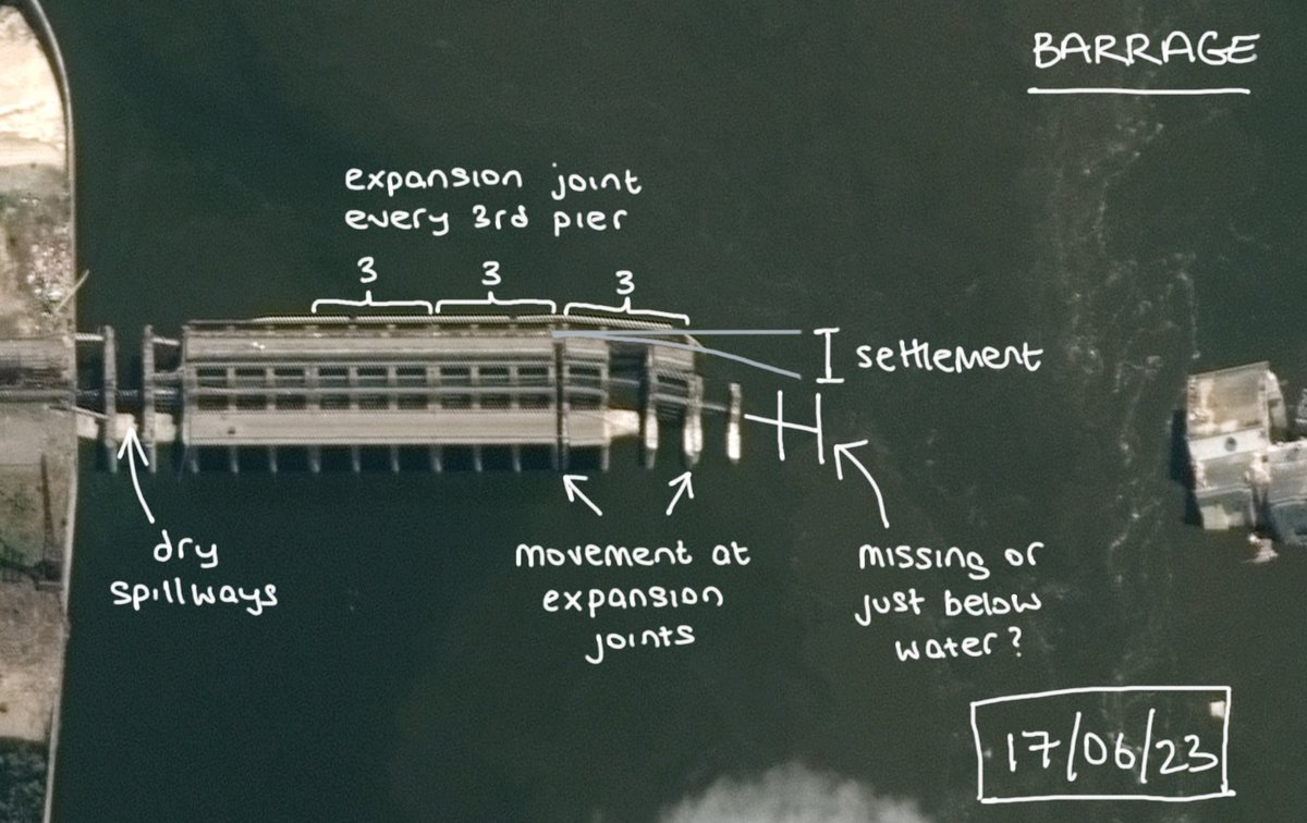
On the BARRAGE, the dry spillways indicate that the water level has dropped close the normal downstream level, but there's no sign of any damaged piers or dam structure in the destroyed span yet.

There *is* clear settlement of the barrage structure at the edge of the breach. The NYT is treating this as a smoking gun from an explosion in the drainage gallery, but this doesn't yet prove this chain of events without seeing what's underwater.
https://t.co/fBWalddWzBnytimes.com/interactive/20…
https://t.co/fBWalddWzBnytimes.com/interactive/20…
Long structures like dams and bridges have regular expansion joints to allow for movement in the structure without stress build-up.
Remember, this played a big role in the failure mechanism of the Crimean Bridge:
Remember, this played a big role in the failure mechanism of the Crimean Bridge:
https://twitter.com/andrew_barr/status/1579147603467698177
In the Kakhovka barrage, every third pier is a little wider, and incorporates a vertical joint.
Seals are provided to ensure these joints stay watertight, and any water that does seep through should end up in the drainage gallery.
Seals are provided to ensure these joints stay watertight, and any water that does seep through should end up in the drainage gallery.

The damage which caused the initial breach evidently affected the concrete apron enough that the underlying soil could be scoured away.
The presence of the expansion joints meant that the barrage was free to settle in 3-pier segments. (Image HT @JonHallin)
The presence of the expansion joints meant that the barrage was free to settle in 3-pier segments. (Image HT @JonHallin)

Again, frustratingly this settlement means that the structural evidence for (or against) an explosive demolition remains just below the waterline in the destroyed section, although I still think this is the most likely cause.
The lower water level does reveal what's left of the HYDROELECTIC POWER PLANT. In the middle section, the top of at least one generator is clearly visible.

Specifically, what's visible is the distinctive hash (#) pattern of the steel beams on the turbine room floor around the tops of the generators.

We can also see the structure around the control gates that was visible in videos when the water was higher, and large sections of concrete debris from what I assume are the walls. There's also debris on the roof of the section nearest the barrage.
That's about all we can tell from an image of this quality - if anyone's seen any recent photos/video of the HPP now the water level has dropped please share!
Expansion joints between the four building sections have allowed them to move independently, but the way the section nearest the barrage has settled and broken apart is very odd, and I still can't figure it out.

This settlement also appears to have happened before the complete collapse of the central section, so the sequence of events here seems even more unclear. (Video HT @JonHallin)
So this isn't quite Part 3 of the thread, more of a Part 2b. To be continued...
Update: Several people have asked about erosion downstream of the dam as a possible source of damage. It's worth discussing, so I guess this is #KakhovkaDam thread Part 2c! 🧵
I'll refer to this updated diagram of the barrage apron:
I'll refer to this updated diagram of the barrage apron:

Without mitigating structures, the high speed of water released from a dam can quickly cause erosion of the riverbed downstream, and so engineers put a lot of thought into controlling the flow and avoiding scour.

The Kakhovka Dam is built on fine sand, and so is provided with an apron 100m long to prevent this soil layer being washed away when water is released. The first step is a concrete stilling basin, which dissipates energy through turbulence in the water.

The stilling basic creates a slower, steadier flow downstream, but to further protect the sand bed a longer downstream apron is provided. This includes features such as inverted filters, which help release any uplift pressures under the apron without sediment loss.
At Kakhovka the apron is also fixed at the end with what "Hydropower and Integrated Use of Water Resources of the USSR" describes as a 'tooth' structure to anchor the end in place against water ingress and uplift.
Satellite images on 28th May showed a partial collapse of the waterbreak wall next to the HPP, followed by the collapse of several previously damaged road spans and bridge piers on 5th June. Is this damage from erosion?

The erosion image I used above was from the failure of the Oroville Dam spillway in the US, in 2017. This is an embankment dam, but damage to the concrete spillway occurred during a period of high rainfall after water uplift dislodged concrete panels.

Significant scour of the underlying soil quickly followed. (It emerged that the 'rock' under the spillway was of a much lower strength than assumed by the engineers, and was actually a mix of weathered rock and soil.)
This kind of erosion tends to propagate back upstream towards the dam face and can jeopardise the stability of the whole structure. It's possible that something similar could happen at Kakhovka, but the drawings suggest great care was taken to account for the ground conditions.

I lack the expertise to comment on whether the water flow through the open gates of the dam before its collapse would be considered to exceed the design loading, but this is a relatively low-head dam. (Oroville is massive, but it's a well-documented recent example!)
If erosion of the underlying soil alone had caused an overturning failure of the barrage, I'd also expect to see some sort of evidence of the dam segments in a new position now that the water level has dropped. It's hard to hide blocks of concrete 21m high!

So again, while the timing, seismic/infrared data etc all point towards an explosive demolition, for now the real answer from a strictly structural point of view is still hidden under the water.
• • •
Missing some Tweet in this thread? You can try to
force a refresh