50% of humans live in this circle
But why?
It's not a coincidence
It's because of a single, massive accident
Why?
Let's zoom in:
But why?
It's not a coincidence
It's because of a single, massive accident
Why?
Let's zoom in:
🇵🇰Pakistan 230M
🇮🇳India 1,400M
🇳🇵Nepal 30M
🇧🇩Bangladesh 170M
🇲🇲Burma 54M
🇹🇭Thailand 71M
🇻🇳Vietnam 97M
🇨🇳China 1,400B
🇹🇼Taiwan 23M
🇮🇩Indonesia 274M
🇲🇾Malaysia 33M
🇵🇭Philippines 114M
🇯🇵Japan 126M
🇰🇵NK 26M
🇰🇷SK 52M
TOTAL > 4B
Did one thing cause most of these?!
Yes
🇮🇳India 1,400M
🇳🇵Nepal 30M
🇧🇩Bangladesh 170M
🇲🇲Burma 54M
🇹🇭Thailand 71M
🇻🇳Vietnam 97M
🇨🇳China 1,400B
🇹🇼Taiwan 23M
🇮🇩Indonesia 274M
🇲🇾Malaysia 33M
🇵🇭Philippines 114M
🇯🇵Japan 126M
🇰🇵NK 26M
🇰🇷SK 52M
TOTAL > 4B
Did one thing cause most of these?!
Yes
Let's start with India. I covered it here:
Quick summary:
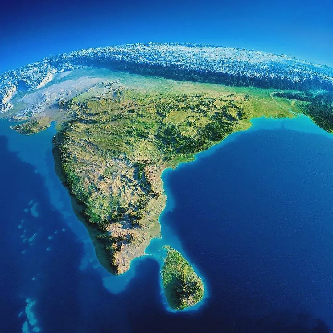
India is hot because of its location & wet because of monsoons
Monsoon waters are stopped by the Himalayas, forming the Ganges River valley, which brings water & fertile sediments➡️food➡️ppl
Quick summary:
India is hot because of its location & wet because of monsoons
Monsoon waters are stopped by the Himalayas, forming the Ganges River valley, which brings water & fertile sediments➡️food➡️ppl
https://twitter.com/tomaspueyo/status/1622753371663867905
The Himalayas, of course, are formed by the Indo-Australian tectonic plate hitting the Eurasian plate
The monsoon is caused by Eurasia: its massive landmass warms up the air a lot in summer. It goes up, and pulls in the wet air from the Indian Ocean
The monsoon is caused by Eurasia: its massive landmass warms up the air a lot in summer. It goes up, and pulls in the wet air from the Indian Ocean

This explains India's 1.4B ppl, but also Nepal's 30M: Most of its population is on the southern, flatter Ganges valley
And of course, the same thing is true for Bangladesh's 170M, since the country is just the mouth of the Ganges river (a fertile delta) and its confluence with the Brahmaputra river
The same is true of Pakistan! But with the Indus River Valley vs Ganges
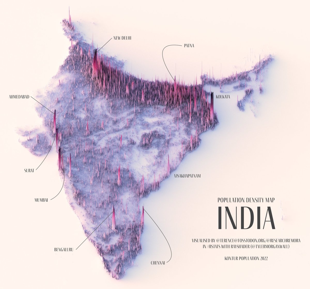
Compare the population density (left) and the satellite image (right). Pakistan's population is mostly in the Indus Valley!
And its waters have the same origin as the Ganges'
(@researchremora map)
Compare the population density (left) and the satellite image (right). Pakistan's population is mostly in the Indus Valley!
And its waters have the same origin as the Ganges'
(@researchremora map)


Why is the Pakistani pop nearly limited to the Indus while India also has population outside of the Ganges Valley?
Because most of this region is in the very dry horse latitudes (left). The only reason India is wetter is because it gets much more (monsoon) rainfall (right)
Because most of this region is in the very dry horse latitudes (left). The only reason India is wetter is because it gets much more (monsoon) rainfall (right)


So this explains ~1.8B ppl in 🇵🇰🇮🇳🇳🇵🇧🇩
Now let's move to China. Why is it so populated?
I explained it here
Summary: China is the same as India, except it gets the monsoon from the Pacific, not the India Ocean!
Now let's move to China. Why is it so populated?
I explained it here
Summary: China is the same as India, except it gets the monsoon from the Pacific, not the India Ocean!
https://twitter.com/tomaspueyo/status/1623826367786655745?s=20
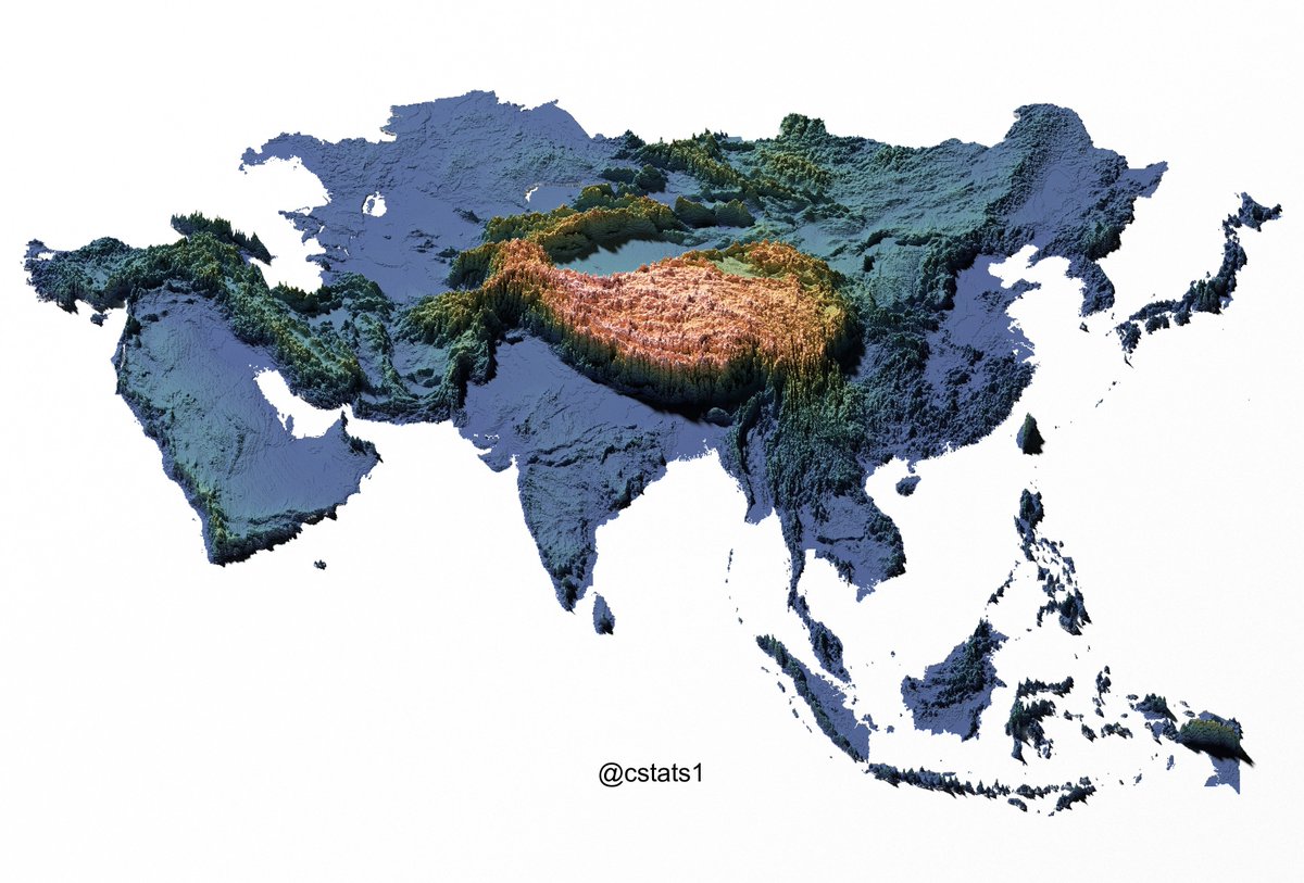
The Tibet stops the winds & their rains, which form the:
Yangtze River basin
Yellow River basin (yellow because of sediments)
Pearl River basin
Yangtze River basin
Yellow River basin (yellow because of sediments)
Pearl River basin

The eastern plains are flattest and concentrate all the rains + sediments➡️arable land➡️crops➡️population
https://twitter.com/tomaspueyo/status/1424792850735190023?s=20
And why are there plains in that area? Because the Pacific tectonic plate is going under the Eurasian one, flattening the surface above!


Of course, North & South Koreas follow a similar logic: their flat valleys have dense population because they're very fertile thanks to the monsoons and sediments brought down by the rivers
Now let's go to Indochina:
Same story!
The Himalayas / Tibet form 4 big rivers basins there. Each created a civilization & pop center
Irrawaddy➡️Burma
Chao Phraya➡️Thailand
Mekong➡️Thailand, Cambodia, South Vietnam
Red River➡️North Vietnam
Same story!
The Himalayas / Tibet form 4 big rivers basins there. Each created a civilization & pop center
Irrawaddy➡️Burma
Chao Phraya➡️Thailand
Mekong➡️Thailand, Cambodia, South Vietnam
Red River➡️North Vietnam

You can see it clearly comparing the topography & river maps (left) with the pop density map (right)
Same concept: monsoons+mountains➡️rivers➡️water+sediments➡️fertile flatlands➡️crops➡️ppl
(@PythonMaps)
Same concept: monsoons+mountains➡️rivers➡️water+sediments➡️fertile flatlands➡️crops➡️ppl
(@PythonMaps)


OK so that explains ~3.5B ppl on the continent
But what about the islands? We're missing the vast populations of Indonesia, Philippines, Japan & Taiwan. 500M ppl. Surely, they can't have the same explanation, right?
Look at the map
What's special about all these islands?
But what about the islands? We're missing the vast populations of Indonesia, Philippines, Japan & Taiwan. 500M ppl. Surely, they can't have the same explanation, right?
Look at the map
What's special about all these islands?
Notice the big trenches on their coasts?
They're all on tectonic plate borders!
The Indo-Australian & Pacific plates are going under the Eurasian plate just where all these islands are.
Is that a coincidence?
They're all on tectonic plate borders!
The Indo-Australian & Pacific plates are going under the Eurasian plate just where all these islands are.
Is that a coincidence?

No, of course! It's the subduction of the plates that is forming all these islands!
They are nearly all of volcanic origin. This is why we call all that region the Ring of Fire!
They are nearly all of volcanic origin. This is why we call all that region the Ring of Fire!
In fact, some islands in the area are not volcanic, like Borneo, and *those islands have a much lower population*!
Why? Because they don't have volcanoes, so their land is not fertile! It's been leached by eons of rains.
Volcanoes replenish nutrients
Why? Because they don't have volcanoes, so their land is not fertile! It's been leached by eons of rains.
Volcanoes replenish nutrients

Volcanoes both create the islands and then fertilize them, which allows for better farming➡️food➡️ppl
I explain here why it's the volcanic fertility that causes the dense populations of these islands
unchartedterritories.tomaspueyo.com/p/why-is-java-…
I explain here why it's the volcanic fertility that causes the dense populations of these islands
unchartedterritories.tomaspueyo.com/p/why-is-java-…
Heat + rains also help
The heat & rains in Indonesia / Philippines are caused by the proximity to the equator.
Taiwan & Japan catch the Asian Gulf Stream (Kuroshio Current) for heat and the same monsoon as China for water
The heat & rains in Indonesia / Philippines are caused by the proximity to the equator.
Taiwan & Japan catch the Asian Gulf Stream (Kuroshio Current) for heat and the same monsoon as China for water
OK, so what's the big accident that is causing the massive population of this circle?
The collision between the Eurasian, Pacific, and Indo-Australian plates!
The collision between the Eurasian, Pacific, and Indo-Australian plates!

1. Massive Eurasian plate➡️pulls in monsoons from surrounding oceans
2. Plate Collision➡️Himalayas/Tibet form➡️catch the monsoon waters➡️massive, fertile river valleys
3. The collisions also form volcanoes➡️ring of islands+natural fertilizer
4. All of this in a hot area
2. Plate Collision➡️Himalayas/Tibet form➡️catch the monsoon waters➡️massive, fertile river valleys
3. The collisions also form volcanoes➡️ring of islands+natural fertilizer
4. All of this in a hot area

🌡️Heat+💧water+💩fertilizer➡️🌿crops➡️🧑🤝🧑ppl
I go into a lot more detail in the article below:
unchartedterritories.tomaspueyo.com/p/why-do-half-…
I go into a lot more detail in the article below:
unchartedterritories.tomaspueyo.com/p/why-do-half-…
If you liked this & want more, follow me. A thread like this every ~week
Or better, sign up for the newsletter. It's free!
Much more like this coming
unchartedterritories.tomaspueyo.com/subscribe
Or better, sign up for the newsletter. It's free!
Much more like this coming
unchartedterritories.tomaspueyo.com/subscribe
• • •
Missing some Tweet in this thread? You can try to
force a refresh