1/ It has been 3 months since the Russians blew-up the Kakhovka HPP dam on 6 June 2023. What is happening to the Dnipro River hydrology and ecology? What are are the options for rebuilding the HPP and possibility for a Dnipro left-bank beachhead? A #NAFOWeather 🧵
Outline:
Outline:

2/ K-HPP Destruction Impacts:
- Irrigation/agricultural land lost: 350,000-550,000 ha
- Drinking (population 700,000) and industrial water loss
- Zaporizhzhia NPP cooling pond water supply loss
- 14,000 homes flooded, many drowned
topleadprojects.com/environmental-…
theguardian.com/world/2023/jun…
- Irrigation/agricultural land lost: 350,000-550,000 ha
- Drinking (population 700,000) and industrial water loss
- Zaporizhzhia NPP cooling pond water supply loss
- 14,000 homes flooded, many drowned
topleadprojects.com/environmental-…
theguardian.com/world/2023/jun…
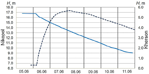
3/ 6-11 June Water Level Changes: Nikopol (left y-axis) and Kherson City (right y-axis) from Vyshnevskyi, et al, 2023
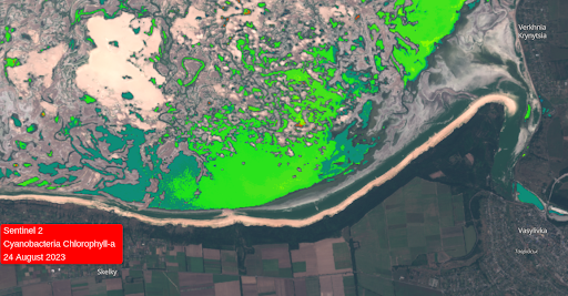
Immediately after the Russians blew up the K-HPP dam, the Kakhovka Reservoir water level began lowering and within 6 hours, the Kherson City water level increased
Immediately after the Russians blew up the K-HPP dam, the Kakhovka Reservoir water level began lowering and within 6 hours, the Kherson City water level increased
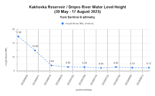
4/ Sentinel 6 data Dnipro River water level observations below the K-HPP peaked at 6.81 meters (11 JUN) falling back to about 0.6 meter near normal water level. @PoleTheia
hydroweb.theia-land.fr/hydroweb/view/…
hydroweb.theia-land.fr/hydroweb/view/…
5/ Sentinel 6 water level data near Nikopol prior to K-HPP destruction was 17.42 meters now varying between 6.06 and 6.36 meters (6 meters is pre-reservoir (1955) level average per Vyshnevskyi, et al, 2023)
ipad.fas.usda.gov/lakes/images/l…
ipad.fas.usda.gov/lakes/images/l…
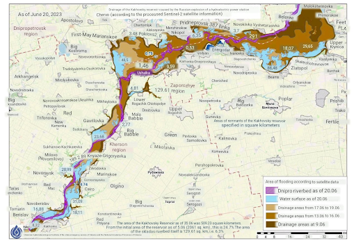
6/ From 5 to 20 June, the water "mirror" area (aerial coverage of water) decreased to 24% of the original 2061 km**2 area, per Ukrainian Hydrological Institute using Sentinel 2 imagery

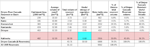
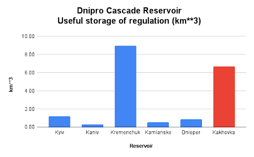
7/ Background on the Dnipro Cascade (6 reservoirs on the Dnipro River):
- The Dnipro basin extends into western Ukraine, northern Belarus, and western Russian
- Kakhovka HPP was the 6th of 6 reservoirs on the Dnipro cascade.
- The Dnipro basin extends into western Ukraine, northern Belarus, and western Russian
- Kakhovka HPP was the 6th of 6 reservoirs on the Dnipro cascade.

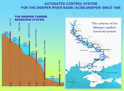
8/ Background on the Dnipro Cascade
The Kakhovka HPP Reservoir held 6.68 km**3 of useful water storage, about 36% of all useful water storage in the entire Dnipro Cascade.
riob.org/IMG/pdf/P-_Kov…
The Kakhovka HPP Reservoir held 6.68 km**3 of useful water storage, about 36% of all useful water storage in the entire Dnipro Cascade.
riob.org/IMG/pdf/P-_Kov…
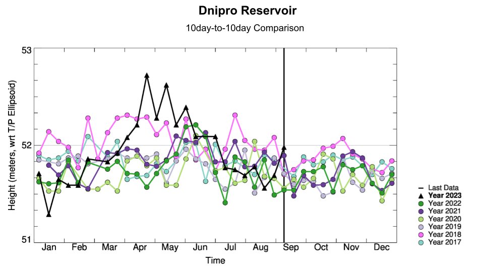
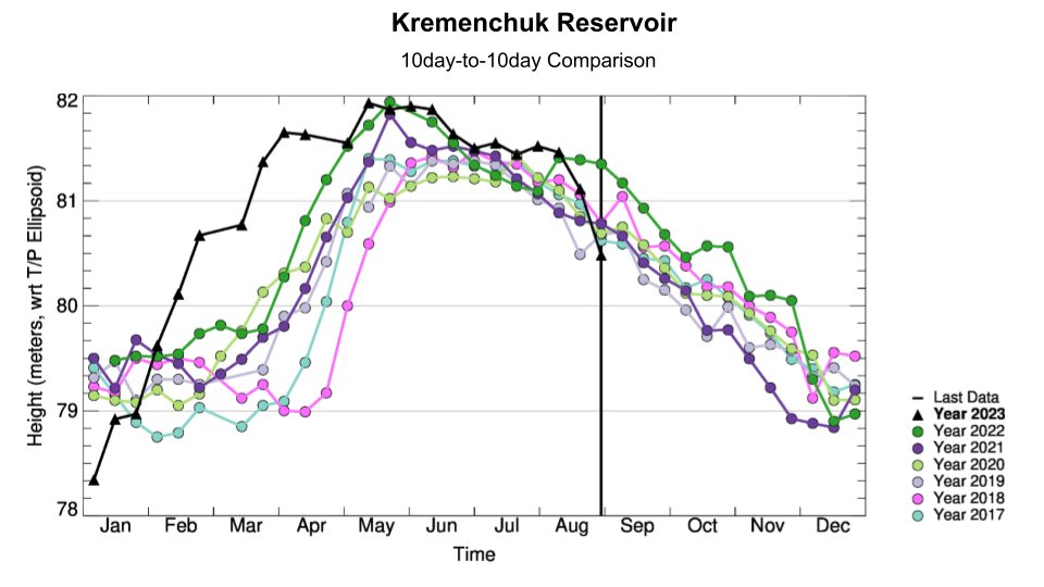
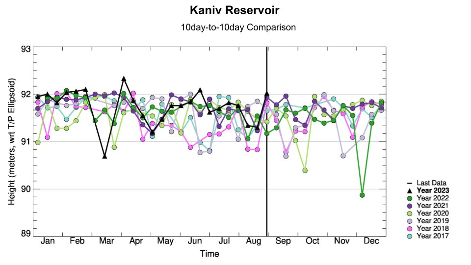
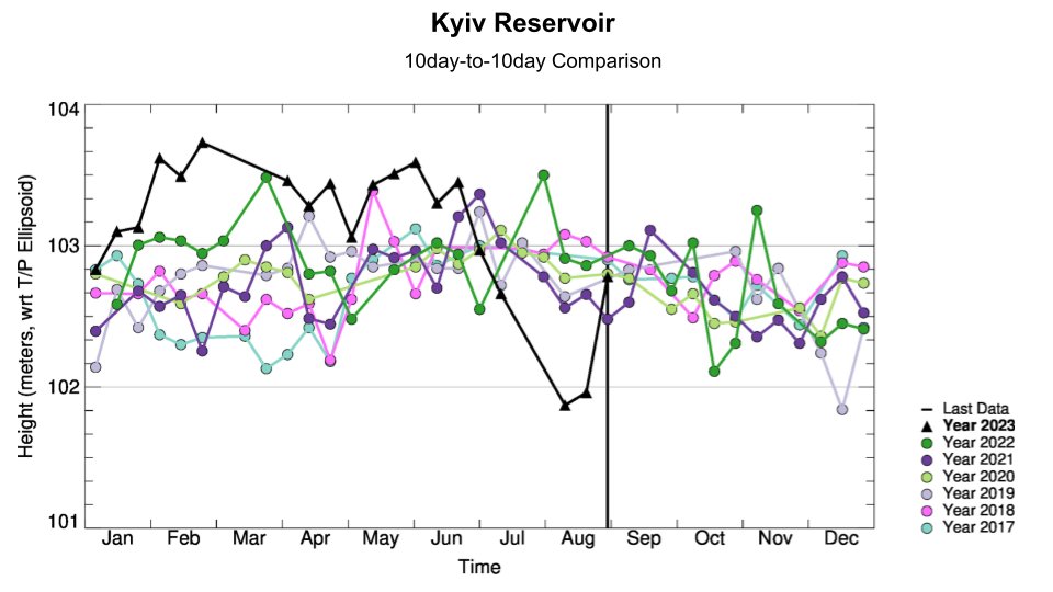
9/ Sentinel 6 has water level trend data are available for 3 of 5 remaining reservoirs. Kyiv and Kaniv levels are above normal, while Kremenchuk (the largest reservoir by far) water level is below normal. Reservoir level anomaly conditions from @NASA
blueice.gsfc.nasa.gov/gwm/lake/Index
blueice.gsfc.nasa.gov/gwm/lake/Index
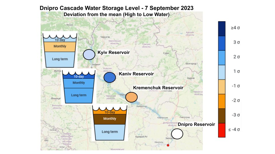
10/ According to @Ukrhydroenergo , water is being discharged to generate electricity during repair of other TPP, HPP, and NPP power generation units necessary to improve system availability to meet winter demands. Trend graphs from @nasa BlueIce page.
en.uhe.gov.ua/news/operation…
en.uhe.gov.ua/news/operation…
11/ Focus on the Dnipro Floodplain (former Kakhovka Reservoir) time-series, JUN-SEP 2023
Kakhovka - Lower Floodplain
Sentinel 2 Optimized Color
Kakhovka - Lower Floodplain
Sentinel 2 Optimized Color
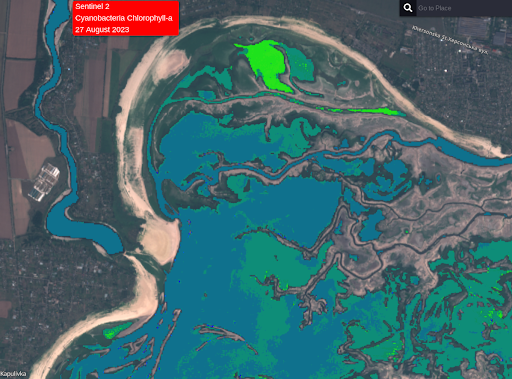
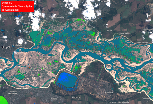
12/ Focus on the Dnipro Floodplain (former Kakhovka Reservoir) time-series, JUN-SEP 2023
Kakhovka - Lower Floodplain
Sentinel 2 Chlorophyll-a (thanks @tom_bike!)
Chlorophyll-a algorithm does a good job identifying open water & water quality (eutrophication, algae) from dry land
Kakhovka - Lower Floodplain
Sentinel 2 Chlorophyll-a (thanks @tom_bike!)
Chlorophyll-a algorithm does a good job identifying open water & water quality (eutrophication, algae) from dry land
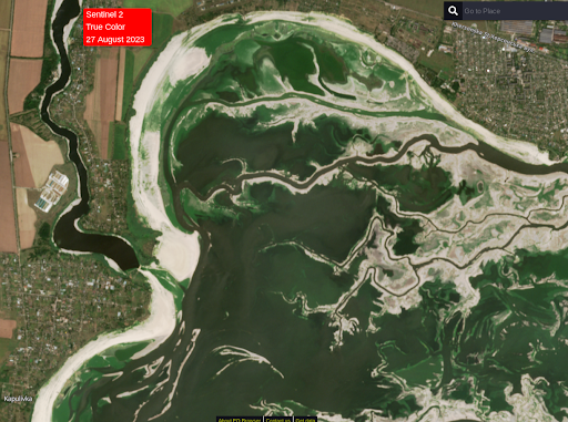
13/ Focus on the Dnipro Floodplain (former Kakhovka Reservoir) time-series, JUN-SEP 2023
Novovorontsovka - Middle Floodplain
Sentinel 2 Optimized Color
Note wetland area near Novovorontsovka seems to increase and decrease.
Novovorontsovka - Middle Floodplain
Sentinel 2 Optimized Color
Note wetland area near Novovorontsovka seems to increase and decrease.
14/ Focus on the Dnipro Floodplain (former Kakhovka Reservoir) time-series, JUN-SEP 2023
Novovorontsovka - Middle Floodplain
Sentinel 2 Chlorophyll-a
Note bright green (elevated algae populations) in isolated pools.
Novovorontsovka - Middle Floodplain
Sentinel 2 Chlorophyll-a
Note bright green (elevated algae populations) in isolated pools.
15/ Focus on the Dnipro Floodplain (former Kakhovka Reservoir) time-series, JUN-SEP 2023
Nikopol-Enerhodar Upper Floodplain
Sentinel 2 Optimized Color
Note significant wetland area on right bank of Dnipro main channel (upstream of Nikopol)
Nikopol-Enerhodar Upper Floodplain
Sentinel 2 Optimized Color
Note significant wetland area on right bank of Dnipro main channel (upstream of Nikopol)
16/ Focus on the Dnipro Floodplain (former Kakhovka Reservoir) time-series, JUN-SEP 2023
Nikopol-Enerhodar Upper Floodplain
Sentinel 2 Chlorophyll-a
Nikopol-Enerhodar Upper Floodplain
Sentinel 2 Chlorophyll-a
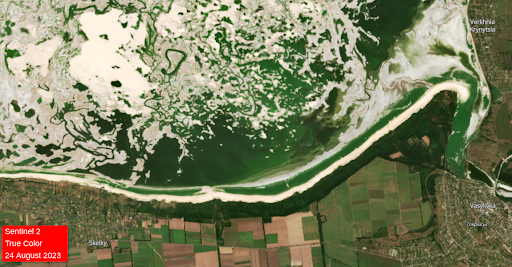
17/ Focus on the Dnipro Floodplain (former Kakhovka Reservoir) time-series, JUN-SEP 2023
Vasylivka - Upper Floodplain
Sentinel 2 Optimized Color
Vasylivka - Upper Floodplain
Sentinel 2 Optimized Color
18/ Focus on the Dnipro Floodplain (former Kakhovka Reservoir) time-series, JUN-SEP 2023
Vasylivka - Upper Floodplain
Sentinel 2 Chlorophyll-a
The isolated wetlands near Vasylivka have such high algae concentration, it is difficult to discriminate from marsh grasses in NDVI.
Vasylivka - Upper Floodplain
Sentinel 2 Chlorophyll-a
The isolated wetlands near Vasylivka have such high algae concentration, it is difficult to discriminate from marsh grasses in NDVI.
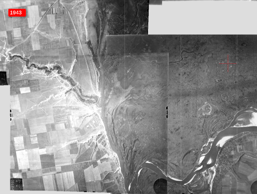
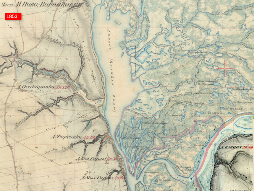
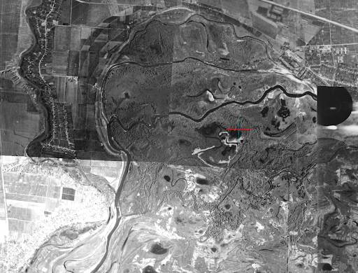
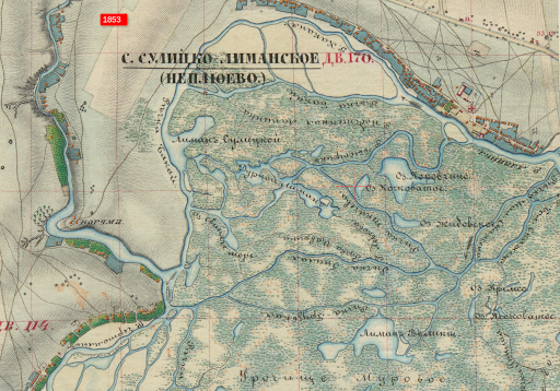
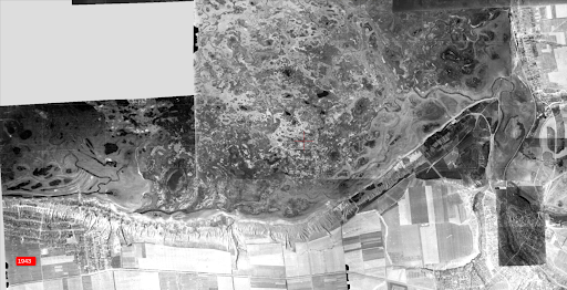
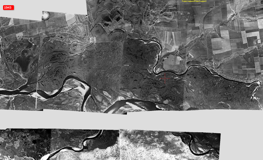
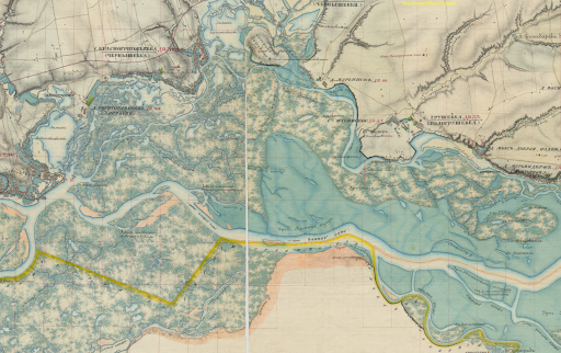
19/ Dnipro Floodplain Comparison - Current to 1943 and 1853
So we are seeing wetland in 20-25% of the Dnipro floodplain (former Kakhovka reservoir). Were there wetlands at these locations 80 years ago? 170 years ago? Let's check old photography and maps
oldmaps.dp.ua/greatlug/?left…
So we are seeing wetland in 20-25% of the Dnipro floodplain (former Kakhovka reservoir). Were there wetlands at these locations 80 years ago? 170 years ago? Let's check old photography and maps
oldmaps.dp.ua/greatlug/?left…

20/ Dnipro Floodplain Wetlands Comparison - Current to 1943 and 1853
Novovorontsovka: Wetlands remarkably similar now as in 1943 and 1853
Novovorontsovka: Wetlands remarkably similar now as in 1943 and 1853
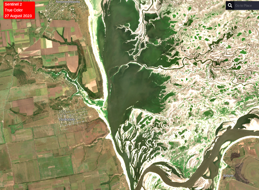

21/ Dnipro Floodplain Wetlands Comparison - Current to 1943 and 1853
Kapulivka: More extensive wetlands now than in 1943 and 1853
Kapulivka: More extensive wetlands now than in 1943 and 1853
22/ Dnipro Floodplain Wetlands Comparison - Current to 1943 and 1853
Vasylivka: Similar wetland now as in 1943 and 1853
Vasylivka: Similar wetland now as in 1943 and 1853

23/ Dnipro Floodplain Wetlands Comparison - Current to 1943 and 1853
Nikopol-Enerhodar: Different (larger) wetland area on right bank now than in 1943 and 1853; drainage likely disrupted due to dredging and levees.
Nikopol-Enerhodar: Different (larger) wetland area on right bank now than in 1943 and 1853; drainage likely disrupted due to dredging and levees.

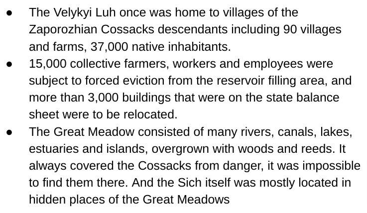
24/ “Great Meadow”/“Velykyi Luh”
Will the future look like the past?
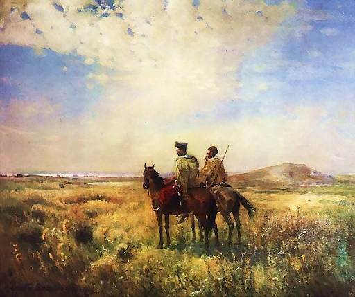
“Velykyi Luh” was once home to the Zaporozhian Cossacks, with settlements, roads, buildings, all flooded in 1955.
Vasyliuk, et al, 2023
uncg.org.ua/en/it-is-time-…
Will the future look like the past?
“Velykyi Luh” was once home to the Zaporozhian Cossacks, with settlements, roads, buildings, all flooded in 1955.
Vasyliuk, et al, 2023
uncg.org.ua/en/it-is-time-…
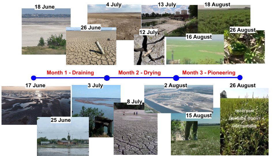
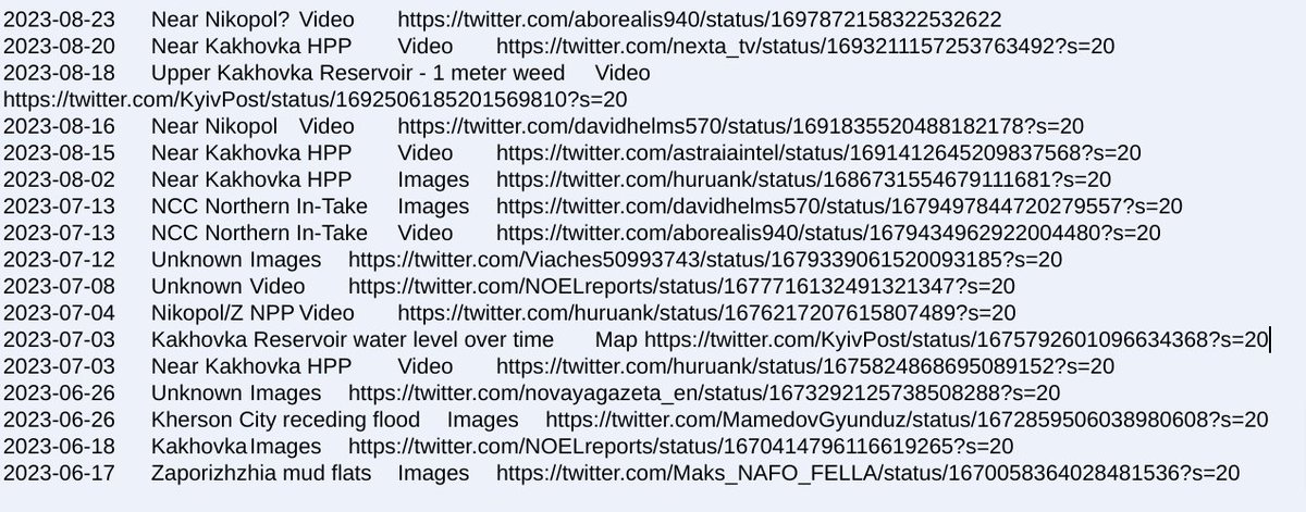
25/ This is a 90 day timeline of Dnipro floodplain images posted to Twitter since 6 June 2023. The images show the floodplain in 3 phases:
Draining -> Drying -> Pioneering
Image sources include: @aborealis940 @nexta_tv @KyivPost @astraiaintel @huruank @NOELreports @MamedovGyunduz
Draining -> Drying -> Pioneering
Image sources include: @aborealis940 @nexta_tv @KyivPost @astraiaintel @huruank @NOELreports @MamedovGyunduz
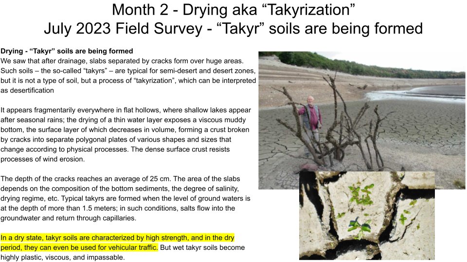
26/ Month 2 - Drying “Takyrization”:
"In a dry state, takyr soils are characterized by high strength, and in the dry period, they can even be used for vehicular traffic. But wet takyr soils become highly plastic, viscous, and impassable."
Dr. Yakiv Didukh
en.ecoaction.org.ua/fate-of-kakhov…
"In a dry state, takyr soils are characterized by high strength, and in the dry period, they can even be used for vehicular traffic. But wet takyr soils become highly plastic, viscous, and impassable."
Dr. Yakiv Didukh
en.ecoaction.org.ua/fate-of-kakhov…
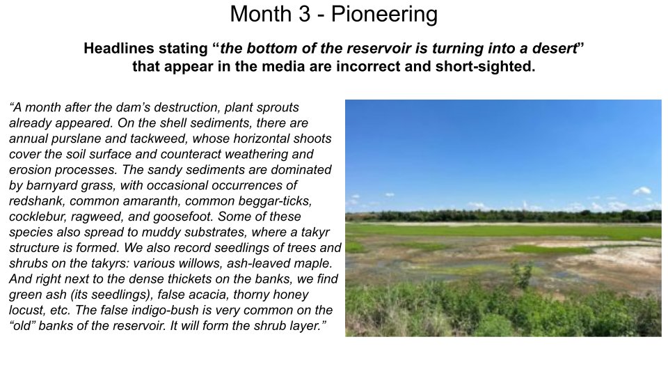
27/ Month 3 - Pioneering
"Headlines stating 'the bottom of the reservoir is turning into a desert' that appear in the media are incorrect and short-sighted." Prof Didukh
Prof Didukh believes the 75-80% the Dnipro floodplain will likely a woody thicket rather than a meadow.
"Headlines stating 'the bottom of the reservoir is turning into a desert' that appear in the media are incorrect and short-sighted." Prof Didukh
Prof Didukh believes the 75-80% the Dnipro floodplain will likely a woody thicket rather than a meadow.
28/ What will the Dnipro floodplain vegetation look like if the water level is left at the current level?
It is time for Velykyi Luh to revive
Oleksiy Vasyliuk, et al, 2023
@ecodiya @ackerm_ann @_UNCG_ uncg.org.ua/en/it-is-time-…
It is time for Velykyi Luh to revive
Oleksiy Vasyliuk, et al, 2023
@ecodiya @ackerm_ann @_UNCG_ uncg.org.ua/en/it-is-time-…

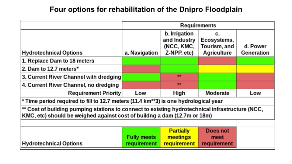
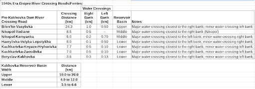
29/ After Ukraine removes Russian invades from its territories, the Dnipro floodplain probably won't be left at the current water level. Several papers outline the 4 hydrotechnical options (see table); no single solution meets all national requirements.
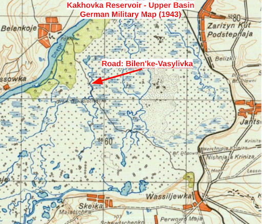
30/ What is the potential for wheeled or tracked vehicles crossing the Dnipro floodplain to establish a beachhead in next 2-4 months? Prof Didukh "In a dry state, takyr soils are characterized by high strength, and in the dry period, they can even be used for vehicular traffic."
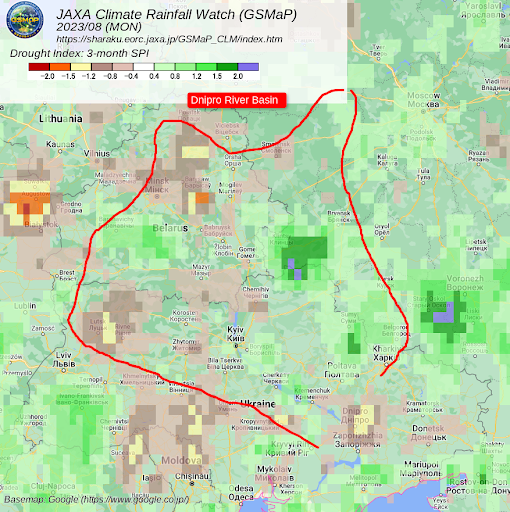
31/ While June & July were relatively wet, August & September have been dry. Over a 90 day period, the Standardized Precipitation Index for the Dnipro basin has been near normal, but the past 30 days lack of rain has caused fire risks to most of Ukraine.
meteo.gov.ua/en/Pozhezhni-p…
meteo.gov.ua/en/Pozhezhni-p…

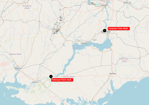
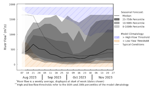
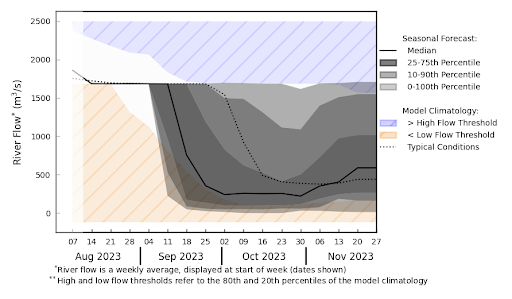
32/ EU GloFAS Hydrologic Prediction System has 2 river flow rate points on the Dnipro floodplain below K-HPP:
Seasonal Forecast Point #564 - Dnipro Power Plant 47.875N 35.075E
Seasonal Forecast Point #629 - Kakhovskoye Vodokhranilishche Ges 46.75N 33.15E
globalfloods.eu/glofas-forecas…
Seasonal Forecast Point #564 - Dnipro Power Plant 47.875N 35.075E
Seasonal Forecast Point #629 - Kakhovskoye Vodokhranilishche Ges 46.75N 33.15E
globalfloods.eu/glofas-forecas…
33/ EU GloFAS seasonal median forecast flow rate for Dnipro HPP is lower than typical flow rate through October, then slightly above typical flow for November 2023.
34/ EU GloFAS seasonal median forecast flow rate for Nova Kakhovka is also lower than typical flow rate through October, then slightly above typical flow for November 2023 (although the forecast initial conditions seems off).
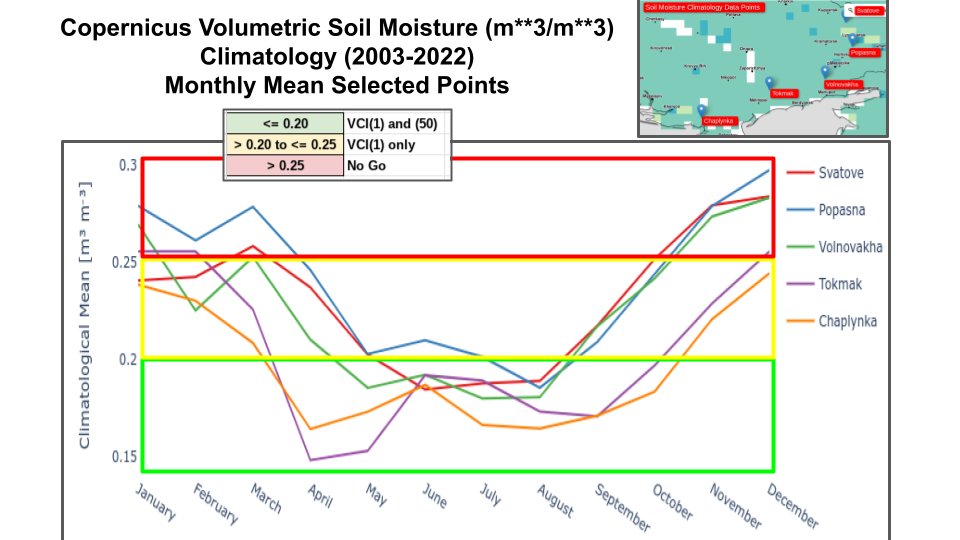
35/ Climatic soil moisture for Kherson is typically marginal to good through early November supporting wheeled and tracked vehicles, degrading after November.
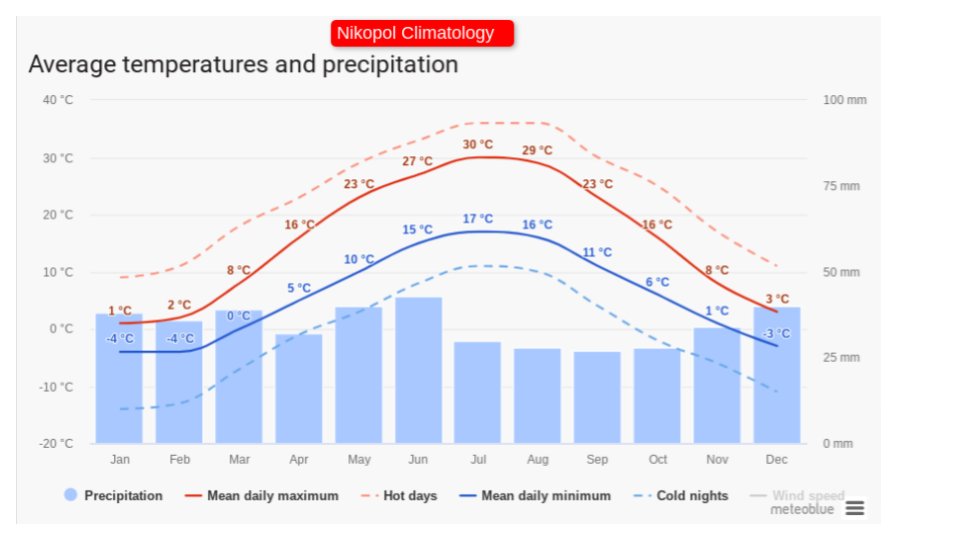
36/ Frost depth will likely be sufficient to support wheeled vehicles in the Dnipro floodplain by mid to late January 2024 through February 2024 with thaws during this 6 week window.
meteoblue.com/en/weather/his…
meteoblue.com/en/weather/his…
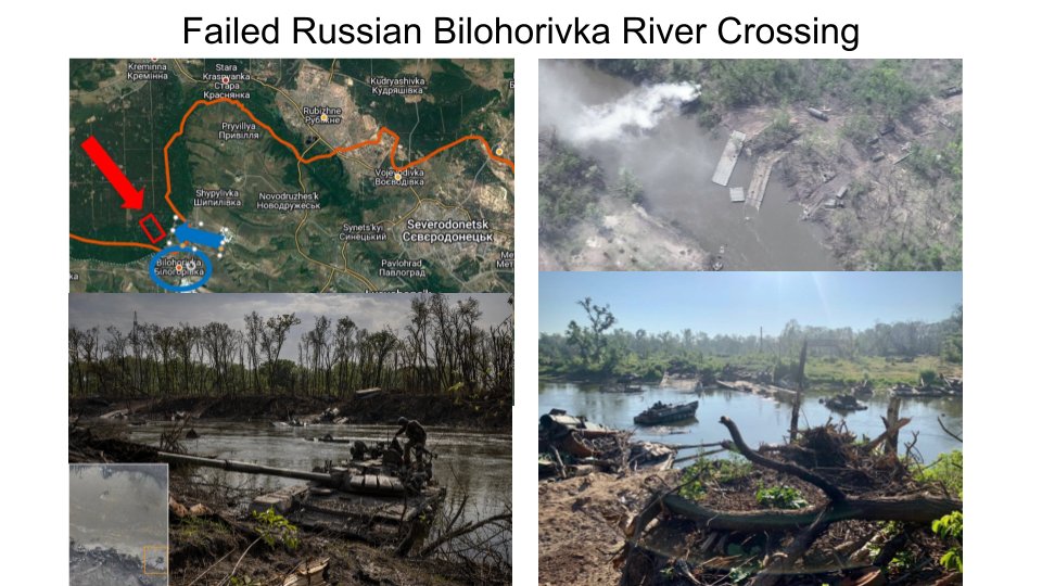
37/ Of course, the Dnipro floodplain near Nikopol has seen successful bridging operations back in WWII.
reddit.com/r/ww2/comments…
reddit.com/r/ww2/comments…

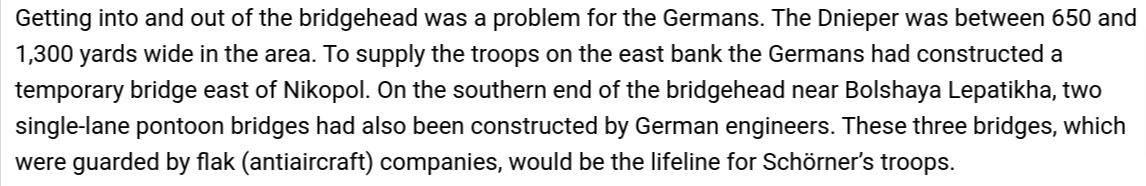
38/ Description of the difficulty the Germans had defending their Nikopol bridgehead against the advancing Russians:
warfarehistorynetwork.com/article/battle…
warfarehistorynetwork.com/article/battle…
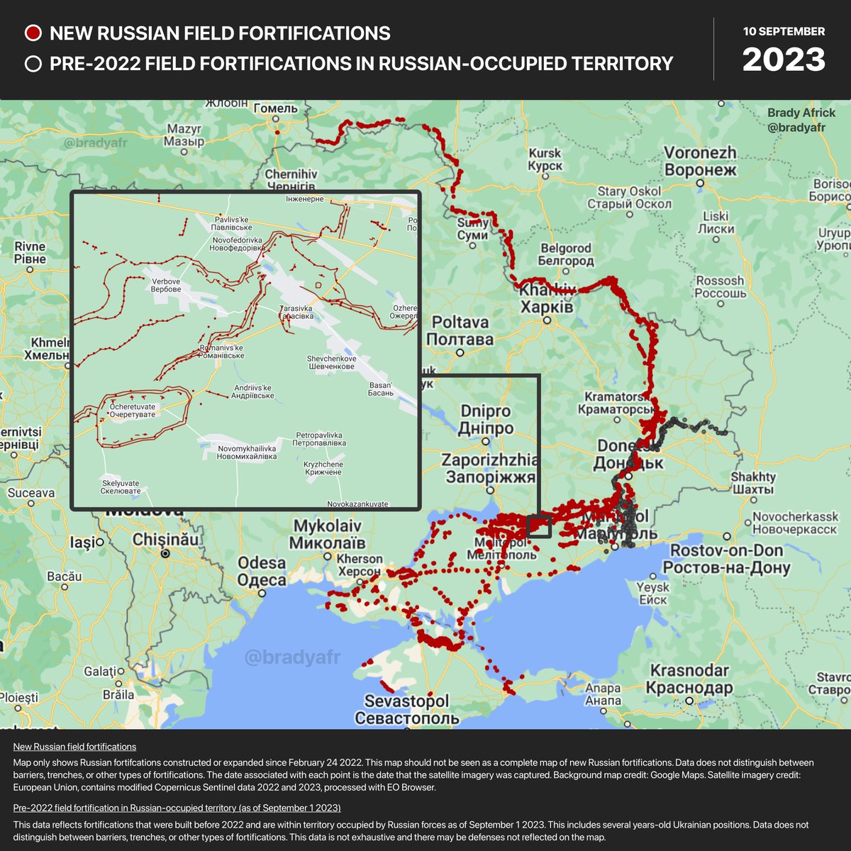
39/ A beachhead across the Dnipro floodplain offers some advantages such as fewer fortifications than south of Orikhiv per @bradyafr
https://twitter.com/bradyafr/status/1700979109093064949?s=20
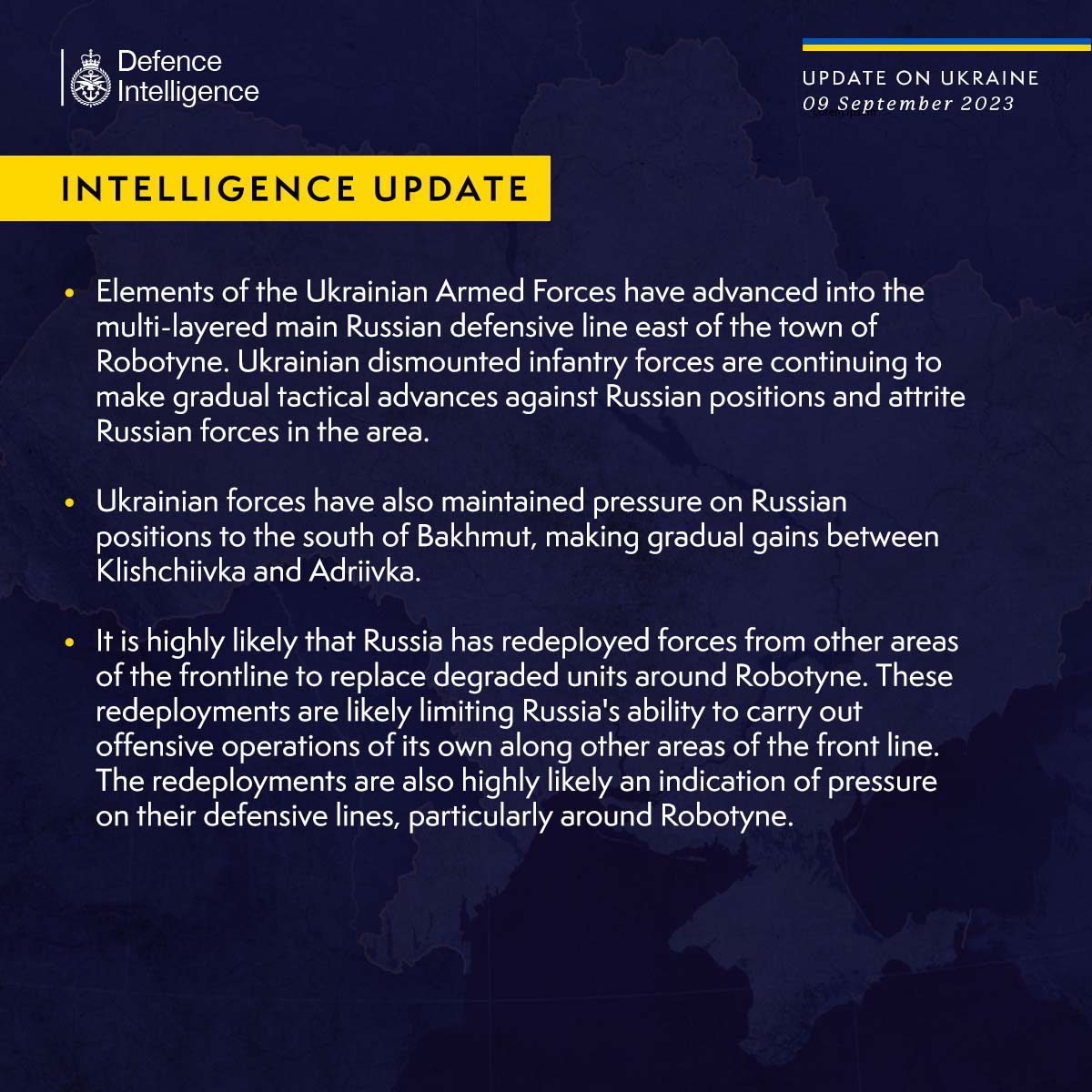
40/ The Russians have likely been redeploying forces away from the Dnipro left bank to defend UAF advances near Robotyne
https://twitter.com/DefenceHQ/status/1700383240459112473?s=20
41/ While the *weather* may allow bridging operations at selected locations until November 1st and again in late January/February, building and protecting a pontoon bridge is very vulnerable to artillery, FPV and missile attacks, especially for the Dnipro.
https://twitter.com/davidhelms570/status/1671236411725426689?s=20
42/ Recall the RF bridging operation on 8 May 2022 where UAF artillery destroyed 500 RF troops and RF 80 vehicles in a rather modest bridging operation across the Siverskyi Donets River.
https://twitter.com/RALee85/status/1545146814298456070?s=20
43/ Ultimately, a successful UAF Dnipro bridging operation will come down to acceptable weather (river width and floodplain trafficability) and most importantly, local air defense and large enough bridgehead to push back RF artillery. /end
Additional Reading:
What will be the fate of the Kakhovka Sea?
27 July 2023
Dr. Yakiv Didukh
Head of department, Department of Geobotany and Ecology, M. G. Kholodny Institute of Botany
National Academy of Sciences of Ukraine
en.ecoaction.org.ua/fate-of-kakhov…
What will be the fate of the Kakhovka Sea?
27 July 2023
Dr. Yakiv Didukh
Head of department, Department of Geobotany and Ecology, M. G. Kholodny Institute of Botany
National Academy of Sciences of Ukraine
en.ecoaction.org.ua/fate-of-kakhov…
It is time for Velykyi Luh to revive
22 August 2023
Authors: Oleksiy Vasyliuk, Viktor Parkhomenko, Ivan Moisiienko, Viktor Shapoval, Serhiy Panchenko and Oleksandr Spriahailo. We would like to thank Yevhen Simonov for his important advice.
uncg.org.ua/en/it-is-time-…
22 August 2023
Authors: Oleksiy Vasyliuk, Viktor Parkhomenko, Ivan Moisiienko, Viktor Shapoval, Serhiy Panchenko and Oleksandr Spriahailo. We would like to thank Yevhen Simonov for his important advice.
uncg.org.ua/en/it-is-time-…
The destruction of the Kakhovka dam and its consequences
23 August 2023
@PeterGleick
Citation: Viktor Vyshnevskyi, et al (2023) The destruction of the Kakhovka dam and its consequences, Water International, 48:5, 631-647,tandfonline.com/doi/full/10.10…
23 August 2023
@PeterGleick
Citation: Viktor Vyshnevskyi, et al (2023) The destruction of the Kakhovka dam and its consequences, Water International, 48:5, 631-647,tandfonline.com/doi/full/10.10…
THE GLORIOUS ZAPORIZHZHYA
cossacks-uan.net/en/vkd/the-glo…
cossacks-uan.net/en/vkd/the-glo…
Rebuilding Ukraine's ruined Nova Kakhovka dam pits history against economic reality
19 June 2023
cbc.ca/news/world/ukr…
19 June 2023
cbc.ca/news/world/ukr…
Ukrhydro Telegram
"If the Kakhovskaya HPP is not rebuilt, there will never be agriculture in the South at all," Oleg Pendzyn, a member of the economic discussion club, told UNIAN.t.me/ukrhydroenergo…
t.me/ukrhydroenergo…
"If the Kakhovskaya HPP is not rebuilt, there will never be agriculture in the South at all," Oleg Pendzyn, a member of the economic discussion club, told UNIAN.t.me/ukrhydroenergo…
t.me/ukrhydroenergo…
*invaders
• • •
Missing some Tweet in this thread? You can try to
force a refresh