One job of a hurricane is to dissipate & redistribute heat. As storms move they churn up the ocean, use/ transport energy, drop heavy-cool rain & upwell cool water from down below. Summer steering took Major Hurricane’s Franklin and Lee over the same region cooling record… 1/
…cooling record hot sea sfc temps. Amazingly, even this large region of cooler water, and active hurricane season, has not been able to change the margin of the record hot anomalies. We are still at 4 standard deviations above normal. Nature’s typical remedies are struggling…2/
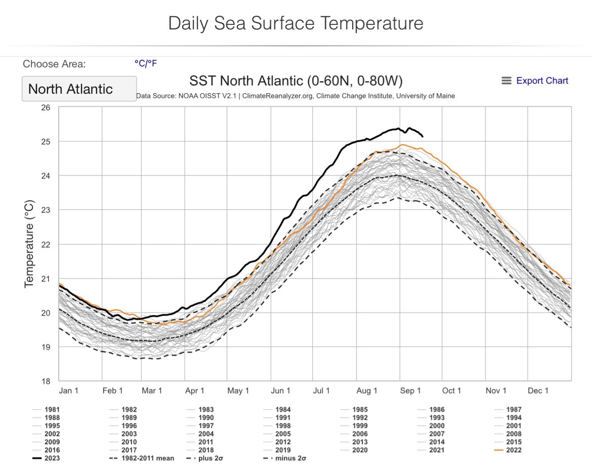
@BMcNoldy has been keeping track of the standard deviations. ~4 sigma right now which is outside of the extreme tail of historical possibilities.
A testament to how extreme & overwhelming the climate is this summer is, this Record “Shattering” heat dome has been barely covered by the national media. It’s largest US heat dome in recent memory and in a large part of the nation’s middle the most intense, by a long shot. 1/
The highest heights (altitude to reach the 500 mb pressure level) on record in Omaha, Springfield & Topeka were around 6000 meters. Heights reached 6020 to 6030 meters. That’s a huge anomaly. This is a measure of heat dome strength… hotter air expands and raises the dome. 2/
Now, these dew points are more than questionable around 90 degrees yielding a heat index of 150… But there are pockets in this area where dewpoints are very elevated due to Corn Sweat/ evapotranspiration of water vapor. Certainly would not be surprised by 130
There’s so many extreme weather and climate stories this weekend, with #Hilary’s impact, many are flying under the radar. This summer we are 1.5C above preindustrial and here’s just a small glimpse of my timeline. I’ve excluded a bunch of events. 1/
I've posted a lot lately about how hot the Gulf of Mexico waters is. The question I always get is, how may this impact hurricanes? I'll answer that and show you just how "off the charts" the Gulf sea surface heat is in this thread, with a couple of stellar visuals 1/
First the Q of hurricanes. This shows the "maximum" potential wind a hurricane can achieve IF conditions are perfect (light wind shear, minimal dry air, no land interaction). The scale maxes out in the Gulf at 170kts (195 mph). BUT perfection is almost never achieved. And this 2/
...year there's a growing El Nino which typically means a less hospitable western Atlantic basin. That's good, because hotter water = stronger storms when conditions are right. For every 1F inc. in ocean temp potential wind increases by 10%. So a 150mph storm can be 165mph 3/
Wow. Even for the bath tub waters in the Gulf of Mexico this is impressive. Clearwater Beach this afternoon 93.4F. Buoy 100 miles west of Tampa Bay 91.5, Old Port Tampa 95, Port Manatee 93. These #'s are about 3-4F above normal. Gulf is at record hot levels which helps... 1/
...explain, with winds from the west, why the low temperature this morning was only 84 (daily record). Dewpoints along the coast have been running 80-82... During the early morning that means a heat index of 95 and with 95+ degree highs, heat index numbers are 110-115+ 2/
Florida is on the edge of a heat dome which is likely to produce 100+ record highs across the South this week. Here in Florida and specifically the Tampa Bay Area, this means our water temps will not likely fall and may actually rise a bit more. 3/
Think July was hot in the desert SW? Aug says hold my beer. A monster heat dome likely by next weekend - the most intense yet this summer. Magenta indicates where all-time record heights are forecast. This on top of PHX so far beating its hottest month on record by almost 4F!! 1/
So far in July PHX avg temp is 102.9
Old record 98.9 in 2020. To beat your hottest month’s temp by ~4 degrees is remarkable. Enter August… This next heat dome is forecast to be around 4 sigma. These heat “ridges” measure the column heat by how high the 500mb pressure sfc is 2/
Since hot air expands, the hotter the column is, the higher it pushes the height in which you would have to ascend to reach a pressure of 500 millibars. Now, this is just a forecast. It may not verify. But the models have had significant support for it. So it seems legit.
Another day of astonishing heat in the shallow waters of Florida Bay & the Keys!! 99.1 F on the edge of the Everglades. Close to a global record. This water is murky/dark so it absorbs more radiation. But even if it's elevated, it shows just how intense this marine heatwave is 1/
Here's the proof. And notice how a nearby site is 97.5. But it's worth mentioning there was a paper recently showing that these shallow water instruments are possibly registering readings up to a 1 degree elevated. 2/
I did speak to our WFLA meteorologist @WFLAamanda who is down there and said the canal temps in the Keys are 96! So this heat is the real deal. We are seeing extensive coral bleaching and death now. 3/