Tatarigami_UA Profile picture
Sep 21 5 tweets 2 min read Twitter logo Read on Twitter
Based on a recently uploaded video by russians, it's evident that Ukrainian forces successfully penetrated the Surovikin Line and disembarked infantry beyond it. Satellite imagery substantiates these developments, hinting at Ukrainian vehicles crossing Surovikin's Line.🧵Thread: Image
2/ A bit further south from the first image, the video captures a crossroad that was shelled by russians. In the background, you can see the burned area near the Surovikin Line, and the presence of black smoke in the image suggests that some object caught on fire. Image
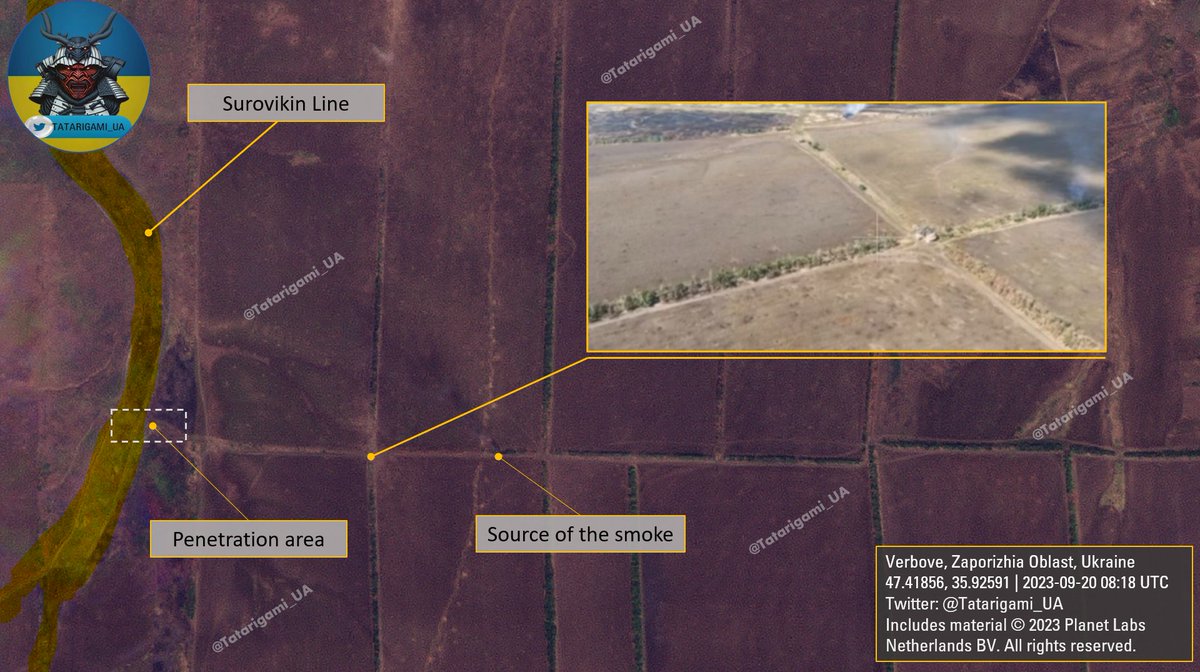
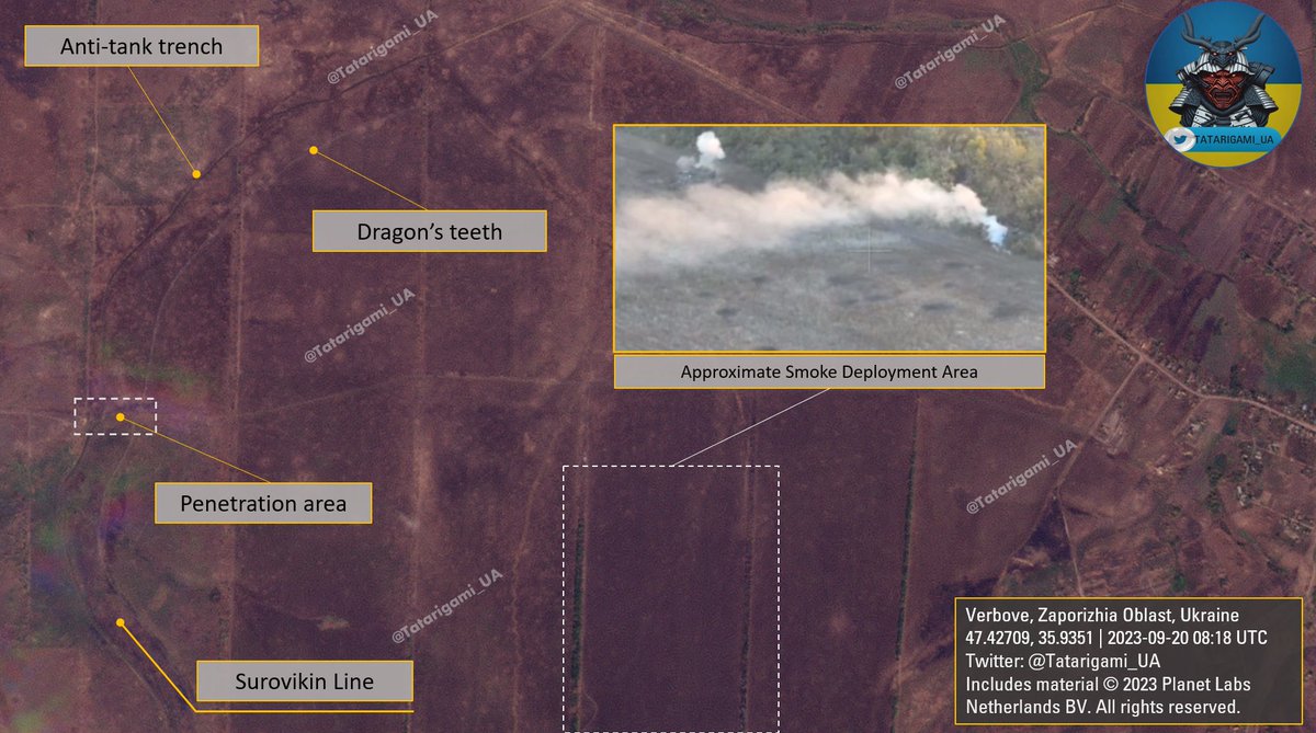
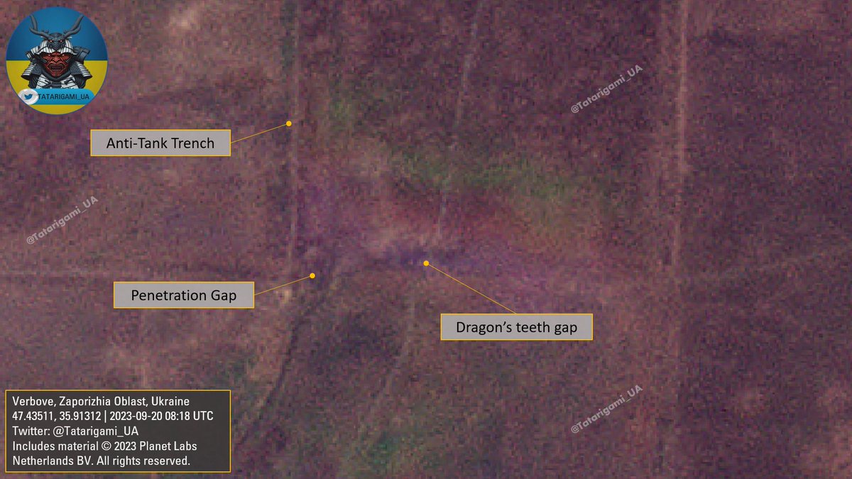
3/ Utilizing geolocation data from the video, it's evident that our forces executed maneuvers effectively, driving back the enemy and exploiting the gap. They have advanced close to Verbove, overcoming AT trenches, minefields, and dragon's teeth. A notable milestone Image
4/ The heavily edited russian video leaves uncertainty about whether our troops established a bridgehead. It's an encouraging and positive sign, and there is no doubt that russians will try to downplay it. The next several days will show if the penetration becomes a breakthrough.
5/ If you found this thread valuable, your support through likes, follows, and retweets of the first message greatly contributes to the visibility and enhancement of my content. Thank you

• • •

Missing some Tweet in this thread? You can try to force a refresh
 

Keep Current with Tatarigami_UA

Tatarigami_UA Profile picture

Stay in touch and get notified when new unrolls are available from this author!

Read all threads

This Thread may be Removed Anytime!

PDF

Twitter may remove this content at anytime! Save it as PDF for later use!

Try unrolling a thread yourself!

how to unroll video
  1. Follow @ThreadReaderApp to mention us!

  2. From a Twitter thread mention us with a keyword "unroll"
@threadreaderapp unroll

Practice here first or read more on our help page!

More from @Tatarigami_UA

Sep 19
With our forces achieving success in Klishchiivka and Andriivka, a new "natural" frontline has emerged along the railroad, effectively separating the opposing sides. In this brief 🧵thread, I'll elaborate on the importance of this phase and provide additional context: Image
2/ As evident in the image created by @DefMon3, the current frontline aligns closely with the railroad, flanked by tree lines on both sides, followed by open fields. Image
3/ The altitude image shows that controlling Andriivka opens up crucial avenues for further advances in the east, south, and north. However, it remains essential to cross the railroad, which the russians use as an obstacle, and focus their defensive efforts there. Image
Read 6 tweets
Sep 18
A brief 🧵thread on the Novoprokopivka-Robotyne-Verbove area updates: Through a comparative analysis of images captured on September 18th and those taken nearly two weeks ago, the landscape changes confirm the combat area and direction of current advances by the Ukrainian army Image
2/ Observing the emergence of new scorch marks, signs of shelling, and the defoliation of tree lines provides a rough estimate of combat engagements and active fire exchange areas. This aligns closely with the map provided by @DefMon3 Image
3/ This is a reference map that can be used independently to verify the data. Not all changes are marked, especially those discussed in the previous thread about Novoprokopivka. Today's map primarily focuses on the eastern and northeastern parts of Novoprokopivka Image
Read 5 tweets
Sep 16
While many experts have provided valuable assessments on the potential submarine damage in Sevastopol, I'd like to add some additional context. After further analyzing and comparing the latest images, I've identified a few noteworthy details. 🧵Thread Image
2/When comparing @BlackSky_Inc 's imagery from September 13th with Planet's from September 15th, I've noticed a green tarp on the submarine's rear section. While its exact purpose is unclear, its presence is unusual, hinting at alleged efforts to conceal something. Image
3/ A quite interesting detail is the appearance of objects resembling water cannons spraying water. Due to image quality limitations, I'll avoid speculations, as image quality prevents me from definitive conclusions, but it's worth noting as another unusual element in the imagery Image
Read 6 tweets
Sep 15
While global attention is primarily on the counter-offensive in the South, there has been noteworthy yet often unnoticed progress in the southernmost part of Bakhmut's defenses. In this thread, I will provide the latest information about Kurdyumivka and its significance.🧵Thread: Image
2/ Kurdyumivka, a small town situated to the south of Bakhmut, holds a tactical advantage due to its elevated position. It offers crucial control over vital roadways connecting Horlivka and Bakhmut, encompassing both highways and railway lines. Image
3/ As illustrated in this image, maintaining control over Kurdyumivka and the eastern heights affords the ability to establish effective fire control and disrupt the enemy's logistical route from Horlivka and Svitlodarsk to Bakhmut, which passes in close proximity to Kurdyumivka Image
Read 17 tweets
Sep 14
Preliminary BDA assessment thread on successful Yevpatoria attack: tonight, videos surfaced, showing explosions in close vicinity to Yevpatoria. Satellite imagery confirms S-400 battery engagement, destroying at least one S-400 TEL near Zaozerne.
🧵Thread: Image
2/ Based on scorch marks and debris, it appears that at least one S-400 Transporter Erector Launcher (TEL) was destroyed. Typically, the S-400 complex includes a command and control center (a truck), two radar units for engagement and acquisition, and multiple TEL's Image
3/ It appears that other vehicles are in motion, having left their revetments, indicating an attempt to relocate. Notably, the absence of the all-altitude detector 96L6-1 suggests that it either wasn't originally present or was the first vehicle removed from the site Image
Read 7 tweets
Sep 14
Preliminary BDA assessment thread on successful Yevpatoria attack: tonight, videos surfaced, showing explosions in close vicinity to Yevpatoria. Satellite imagery confirms S-400 battery engagement, destroying at least one S-400 TEL near Zaozerne. 🧵Thread: Image
2/ Based on scorch marks and debris, it appears that at least one S-400 Transporter Erector Launcher (TEL) was destroyed. Typically, the S-400 complex includes a command and control center (a truck), two radar units for engagement and acquisition, and multiple TEL's Image
3/ It appears that other vehicles are in motion, having left their revetments, indicating an attempt to relocate. Notably, the absence of the all-altitude detector 96L6E suggests that it either wasn't originally present or was the first vehicle removed from the site Image
Read 6 tweets

Did Thread Reader help you today?

Support us! We are indie developers!


This site is made by just two indie developers on a laptop doing marketing, support and development! Read more about the story.

Become a Premium Member ($3/month or $30/year) and get exclusive features!

Become Premium

Don't want to be a Premium member but still want to support us?

Make a small donation by buying us coffee ($5) or help with server cost ($10)

Donate via Paypal

Or Donate anonymously using crypto!

Ethereum

0xfe58350B80634f60Fa6Dc149a72b4DFbc17D341E copy

Bitcoin

3ATGMxNzCUFzxpMCHL5sWSt4DVtS8UqXpi copy

Thank you for your support!

Follow Us on Twitter!

:(