Tatarigami_UA Profile picture
Oct 8 5 tweets 2 min read Twitter logo Read on Twitter
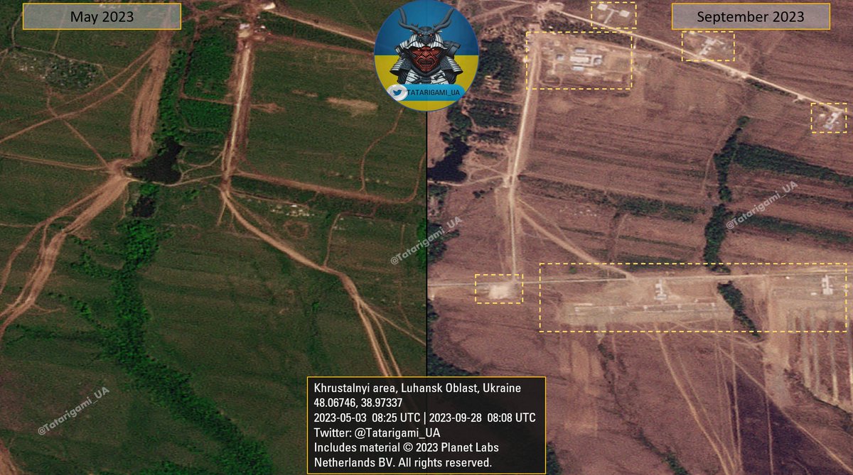
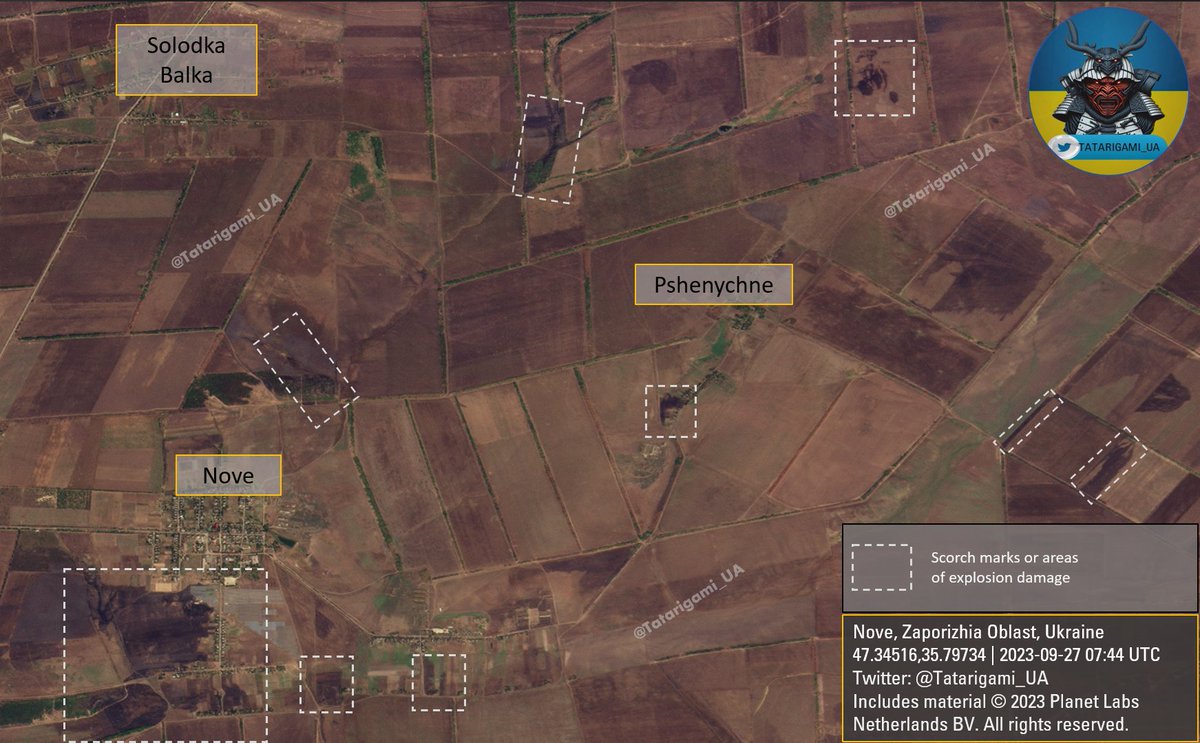
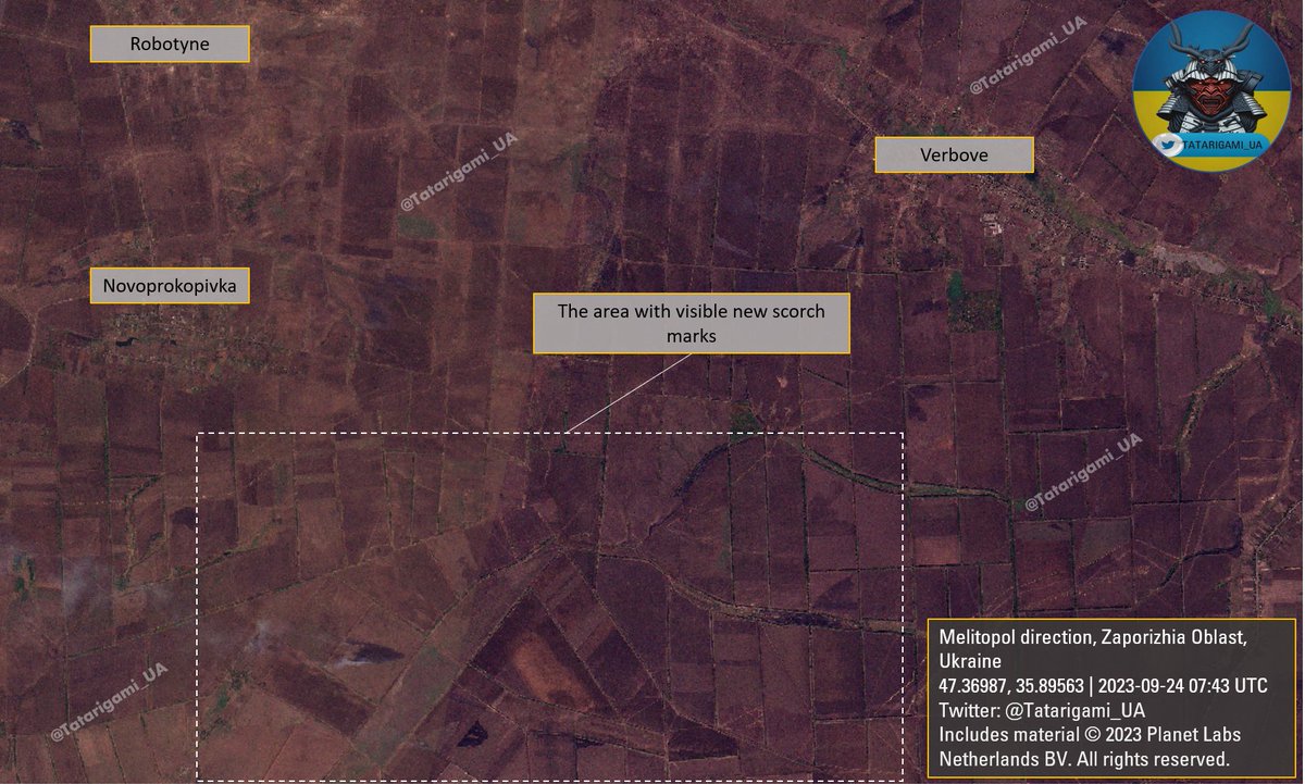
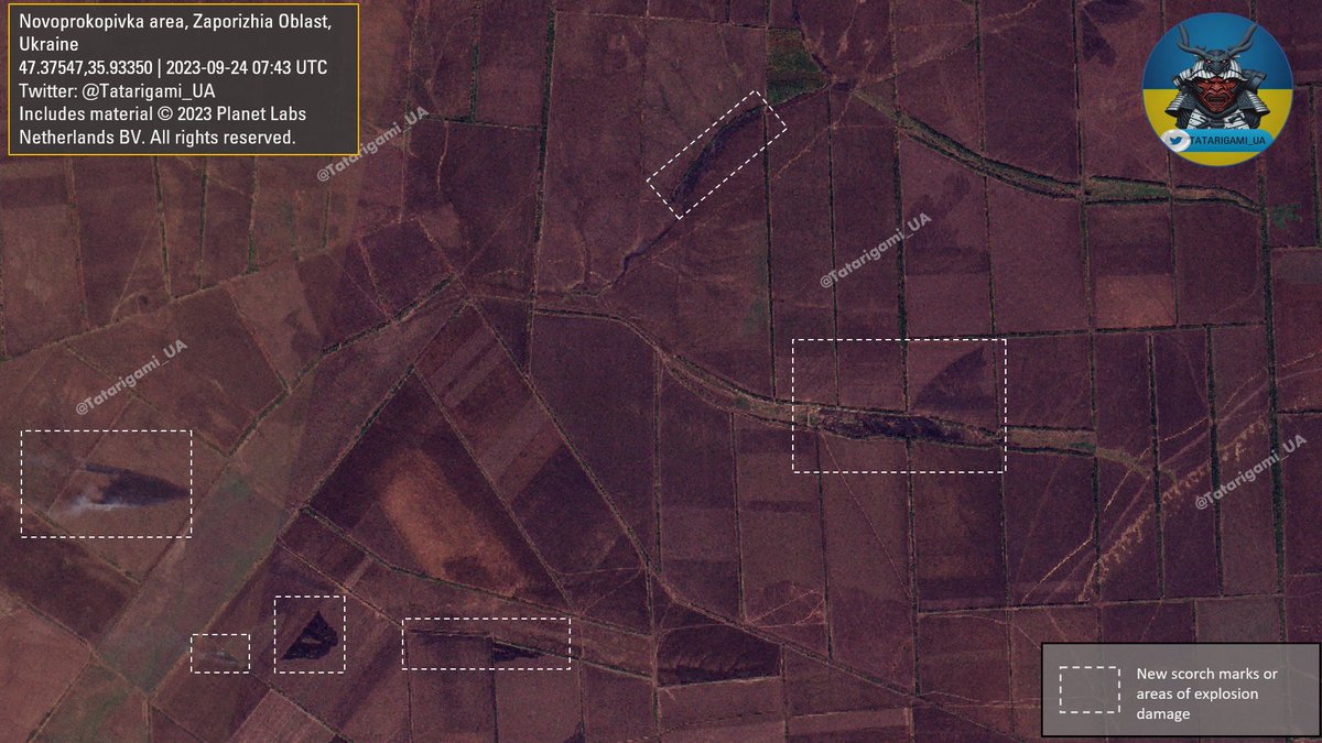
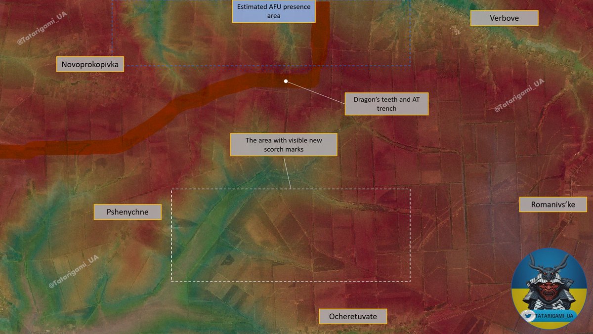
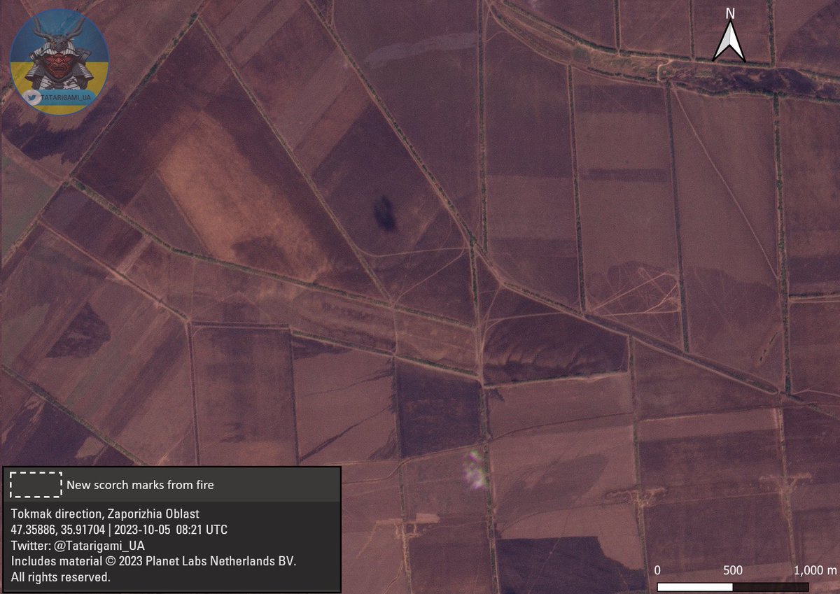
Update on the Verbove-Oceheretuvate-Novoprokopivka area: A comparative analysis of satellite images from October 5th and September 28th shows a shift in the location of the fires, primarily towards the east of Novoprokopivka and to the south of Verbove. 🧵Thread: Image
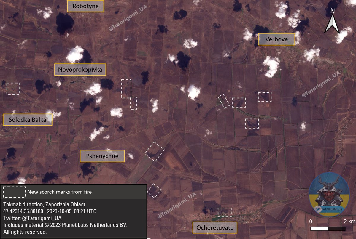
2/ Based on satellite imagery, there are clear indications of fires and shelling in isolated areas near Ocheretuvate. However, the overall situation hasn't seen significant changes over the past week, exhibiting slower dynamics compared to the previous weeks in September. Image
3/ Another noteworthy change is the considerable decrease in visible artillery shelling. This reduction can be interpreted in several ways, such as a shift in tactics and approach, potential shortages of ammunition, or a decrease in the intensity and frequency of assaults.
4/ This aligns with prior reports from Ukrainian officials who have emphasized the necessity of constantly advancing with smaller groups, gradually pushing the enemy back. It appears that the primary focus continues to be on wearing down the enemy's forces and capabilities.
5/ If you find this thread useful, I kindly request you to like, follow, and share the first message in the thread.
These materials are accessible thanks to the support received through Buy Me A Coffee. This support enables me to acquire and share imagery with you

• • •

Missing some Tweet in this thread? You can try to force a refresh
 

Keep Current with Tatarigami_UA

Tatarigami_UA Profile picture

Stay in touch and get notified when new unrolls are available from this author!

Read all threads

This Thread may be Removed Anytime!

PDF

Twitter may remove this content at anytime! Save it as PDF for later use!

Try unrolling a thread yourself!

how to unroll video
  1. Follow @ThreadReaderApp to mention us!

  2. From a Twitter thread mention us with a keyword "unroll"
@threadreaderapp unroll

Practice here first or read more on our help page!

More from @Tatarigami_UA

Oct 10
Targeting becomes challenging when military installations are mixed with civilian infrastructure, particularly in urban areas like Donetsk and Luhansk, where Russian forces frequently operate alongside civilians and utilize active civilian facilities. 🧵Thread: Image
2/ To illustrate this, I selected a military facility used by russian forces in Dovzhansk, located in the rear area of Luhansk Oblast. At first glance, it may not present itself as a military installation due to the presence of numerous civilian vehicles. Image
3/ High-resolution imagery shows military equipment alongside civilian vehicles at this location. Additionally, its proximity to other civilian and industrial structures, coupled with ongoing civilian vehicle activity, strongly indicates the facility's continued use Image
Read 8 tweets
Oct 5
Russians are actively expanding their training ground facilities in the rear areas of Luhansk and Donetsk oblasts and within Russia. This expansion aims to tackle logistical bottlenecks that arose after the 2022 mobilization, signifying efforts to improve infrastructure. 🧵Thread Image
2/ In this specific image, we can observe the emergence of a new training facility with fresh infrastructure within the boundaries of preexisting tank training grounds near the Novopavlivka mining settlement in the Khrustalnyi area of Luhansk oblast. Image
3/ A closer examination of the facility reveals the presence of a training lane designated for infantry and armored vehicles like tanks. Furthermore, multiple clusters of smaller buildings have emerged across the training grounds. Image
Read 6 tweets
Oct 4
Leading up to and during the counter-offensive, many independent observers underestimated the preparedness of russian defenses. Seemingly unremarkable tree lines concealed well-prepared russian positions, fortified and complemented by extensive minefields. 🧵Thread: Image
2/ In Section One, which displays satellite imagery of the tree line near Robotyne on July 13th, it is evident that while there are some noticeable changes near the tree line, such as earthworks, the majority of positions remain concealed and not clearly visible.
3/ In Section Two, the August imagery exposes the presence of russian positions after tree destruction. many observers primarily focused on visible defensive lines, often missing concealed positions. This led to a misconception of vast, empty spaces between the fortifications. Image
Read 11 tweets
Sep 27
Given recent talks in russian Telegram groups about supposed increased pressure from Ukrainian forces, I conducted a visual comparison of images taken on the 24th and 27th of September. Here, I noted distinctions and identified clear patterns. Thread:
1/ Image
2/ As you can see, a number of fresh scorch marks have emerged in recent days. It appears that new visible alterations have occurred to the east and southeast of Novoprokopivka. This aligns with recent reports of Ukrainian Forces activity in the vicinity of Novoprokopivka. Image
3/ Another important development is taking place in the Nove-Solodka Balka-Pshenychne triangle. Numerous recent marks in the region suggest that the Ukrainian Armed Forces have substantially intensified their pressure on more remote defenses. Image
Read 6 tweets
Sep 26
Russian railroads are a critical component of their logistics, allowing the rapid and cost-efficient movement of substantial quantities of ammunition, vehicles, fuel, construction materials, and personnel. Here's a brief 🧵thread with an update on their logistical operations: Image
2/ For a better understanding, let's examine Kantemirovka, a train station in Voronezh Oblast, right across the northern part of Luhansk Oblast, situated out of the range of artillery and HIMARS. It's located only a few hours from critical logistical hubs like Starobilsk Image
3/ In this case, the satellite has recorded the unloading of equipment and vehicles from the train. This typically starts either late at night or early in the morning and finishes by dawn or noon, respectively. Here, many trucks with ammo and equipment had already left. Image
Read 10 tweets
Sep 25
From recent video geoconfirmations, it's clear that the UAF are actively operating near Verbove and Novoprokopivka. Satellite analysis, based on observable landscape changes, supports it and shows fire shifting toward both Verbove and the southern part of Novoprokopivka🧵Thread: Image
2/ This image displays scorch marks and shelling marks, showing recent combat activity. Given the ongoing southward progression of the fire toward Ocheretuvate, it is very likely the AFU pushed russian forces from their positions in the vicinity of Verbove and Novoprokopivka. Image
3/ For a clearer grasp of the tactical situation, terrain understanding is key. The landscape is primarily flat with slight elevations shown on this map. Remember, these elevations are relative to the overall flat terrain, and the red color doesn't always show dominant hills. Image
Read 7 tweets

Did Thread Reader help you today?

Support us! We are indie developers!


This site is made by just two indie developers on a laptop doing marketing, support and development! Read more about the story.

Become a Premium Member ($3/month or $30/year) and get exclusive features!

Become Premium

Don't want to be a Premium member but still want to support us?

Make a small donation by buying us coffee ($5) or help with server cost ($10)

Donate via Paypal

Or Donate anonymously using crypto!

Ethereum

0xfe58350B80634f60Fa6Dc149a72b4DFbc17D341E copy

Bitcoin

3ATGMxNzCUFzxpMCHL5sWSt4DVtS8UqXpi copy

Thank you for your support!

Follow Us on Twitter!

:(