Nathan Ruser Profile picture
Oct 12 3 tweets 1 min read Twitter logo Read on Twitter
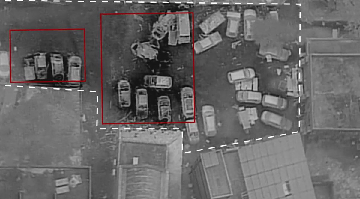
A satellite imagery comparison showing the immense devestation of the university neighbourhood of Gaza City over the past five days of Israeli bombardment.

Harrowing to think how it will look by the end of this.

Pleading for Gazans civilians to make it through this! 🙏
Looking at the ratio between red and infrared bands shows a better view of the actual impacts through the smoke and concrete dust.
This is Beit Hanoun near the Erez crossing.
Absolutely unprecedented levels of bombardment, including of civilian areas. Image
Note that this is not a perfect assessment of the damage, a lot of things other can also show up in this method (infact its primarily for agriculture), so just treat this as a very quick, very first-draft overview.

• • •

Missing some Tweet in this thread? You can try to force a refresh
 

Keep Current with Nathan Ruser

Nathan Ruser Profile picture

Stay in touch and get notified when new unrolls are available from this author!

Read all threads

This Thread may be Removed Anytime!

PDF

Twitter may remove this content at anytime! Save it as PDF for later use!

Try unrolling a thread yourself!

how to unroll video
  1. Follow @ThreadReaderApp to mention us!

  2. From a Twitter thread mention us with a keyword "unroll"
@threadreaderapp unroll

Practice here first or read more on our help page!

More from @Nrg8000

Oct 18
This thread is going around attempting to show 'proof' that Israel was responsible for the explosion at the Gazan hospital.

It does not, the video is from a totally different incident, hour after the hospital blast and shows a strike 1.5-4km away. I'll explain why.
First, I want to preface this analysis by pointing out that this account has been spreading disinformation and denialism about Ukraine for over a year. They have never acted in good faith, but for the people sharing his crap without knowing this I'll refute it at face value.

Image
Image
Image
The argument is immediately refutable since the same camera did film the explosion at the hospital, in footage youve probably seen, an hour earlier, at 6:59pm.
The time stamp in the video he shared is an hour later, at 7:59pm.
Image
Read 11 tweets
Oct 18
🧵Now that day has broken, and we're getting better evidence, I'm willing to share some PRELIMINARY thoughts on the al-Ahli hospital explosion. The photos of the scene are, to me, not consistent with an airstrike and are not consistent with claims that 500+ people were killed.
Image
Image
First, I should mention that this thread isn't a forensic or expert investigation, I'm just sharing what I see and what I've seen previously. Nor am I attributing one way or another. Nor does this negate the countless civilians killed in Israel's campaign.
Photos of the aftermath show that the vast majority of the damage is from fire. Only 3 cars show any clear sign of kinnetic/structural damage. And for two of them, the general structure remains intact - despite clear damage. Image
Read 36 tweets
Sep 22
A 🧵of military defeats of the Burmese junta, who have faced 2 two years of concerted, nationwide revolt against the Sit-Tat and their coup.
Starting with the Daru H'ka bridge outpost. The first major outpost S of Sumprabum, fell to the KIA on Wednesday (2023-09-20) morning.

Image
Image
Image
On Monday (2023-09-18), PDF/CDF fighters overran a Pyu Saw Htee checkpoint near Kant Thet at the entrance to Ka-Pa-Sa (Defence Manufacturing Plant) 23. This attack highlights junta's dwindling manpower, relying on civilian militias to protect a missile-manufacturing facility. Image
On Sunday (2023-09-17), the Sit-Tat launched a military raid from their bases in Indaw towards the Maw Lu town around 30km North. They made it around 3-5km before being attacked by a combined force of KIA and PDF troops before being entirely blocked by the KIA/PDF 6km from town. Image
Read 11 tweets
Jun 13
🧵I've updated this fortifications data to include all Southern occupied Ukraine (Donetsk city - Crimea - Kinburn) with 2,389 fortifications traced from new satellite imagery. A download link is included.
nrg800.users.earthengine.app/view/russianfo…
So what does this mean for the Ukrainian offensive? ImageImageImage
Obviously, the purpose of this data is to provide insight to people far more knowledgable in the military tactics and strategy than me, so I won't focus too much on my armchair general takes, but I do want to share a few quick things that mapping this mas made me realise.
These fortifications look formidable. Russia has clearly invested SIGNIFICANT time and manpower into building a robust and comprehensive main-defensive line behind the front, and these provide challenges to Ukraine that it has not faced before in its offensive operations.
Read 7 tweets
Jun 9
While Ukraine's offensive in Zaporizhia is starting to ramp up, Russia has spent the last 2 months fortifying defensive lines across the entire oblast.
Ive made an interactive map that shows the most recent satellite imagery and these lines.
nrg800.users.earthengine.app/view/russianfo…
Download below ImageImageImage
The satellite imagery shows land over the past two months (since April 15th). Overall, around 1,000 fortification lines have been mapped in the area. These certainly present a challenge to Ukrainian forces trying to move through the landscape and attack in depth.
The fortification data can be freely downloaded (incl for Google Earth) here:
mega.nz/file/LVZnQJoA#…
Anyone is free to use it in any map or publication with attribution to Nathan Ruser/ASPI.
I have tried to be comprehensive, but don't consider this a complete survey. Image
Read 8 tweets
Jun 9
This is incredible, since the collapse of Kakhovka Dam, you can actually see (in @PlanetImagery) the baymetry reflected in the surface currents and flow along with the old path of the river before it was dammed in 1956!
If anyone knows why this is happening, super fascinated. Image
@PlanetImagery It is also evident in Sentinel-2 imagery, though less clearly.
I'm sure it must be some form of how old stagnant water is mixing with the surface flow? but very interested in getting a better idea. Image
@PlanetImagery Here's Harel talking about some of the possibilities on an early post of mine (that I deleted because it was worded as though you actually were seeing the bathymetry not just it reflected in the currents)

Read 4 tweets

Did Thread Reader help you today?

Support us! We are indie developers!


This site is made by just two indie developers on a laptop doing marketing, support and development! Read more about the story.

Become a Premium Member ($3/month or $30/year) and get exclusive features!

Become Premium

Don't want to be a Premium member but still want to support us?

Make a small donation by buying us coffee ($5) or help with server cost ($10)

Donate via Paypal

Or Donate anonymously using crypto!

Ethereum

0xfe58350B80634f60Fa6Dc149a72b4DFbc17D341E copy

Bitcoin

3ATGMxNzCUFzxpMCHL5sWSt4DVtS8UqXpi copy

Thank you for your support!

Follow Us on Twitter!

:(