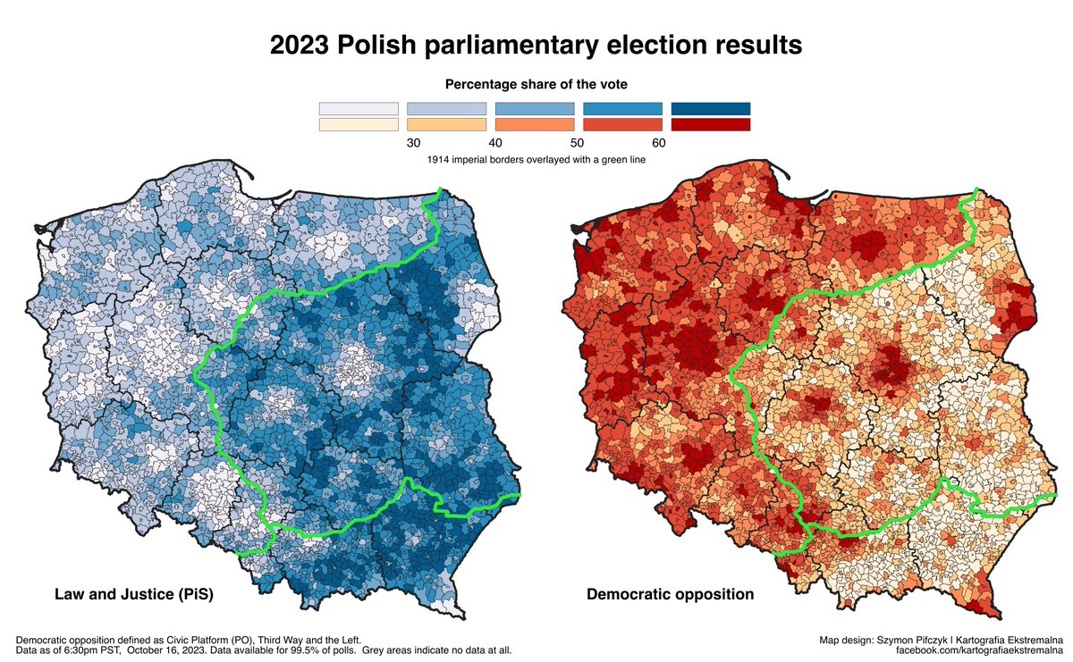
It's 2023, 109 years after WW1 started, yet the pre-WW1 imperial borders are still visible on the election map of Poland - and on many others, for that matter.
A thread 🧵🧵🧵-->
A thread 🧵🧵🧵-->
1. You can see it on the age map of rural areas in Poland. The former Russian part is more aged than the former Prussian and especially the former Austrian one.

2. Speaking of the Austrian part, look at the map of subsistence farming. In Austro-Hungary, farms could be split between all children, which made us end up with thousands of really small farms. In Prussia for example only the oldest son inherited the farm.

3. Back to Russia. Infrastructure is built for a looooong time. Over 100 years after Russia's reign ended in this part of Poland, it still lacks access to bathrooms compared to the other parts.

4. But it's not just man-made infrastructure. The former Russian part is less forested, so accordingly there are less wild boars and deers there, too.

5. There are less companies investing in or trading real estate, too.

6. Want central heating in your new house in Poland? Again, better to avoid the former Russian area.

7. Names starting with "A" are not very common in the Polish language. But for a long time, Russia had a tsar named Alexander. So there are plenty of villages with names starting with "A" in the former Russian part.

8. Poor Eastern Poland also gets more lightnings (probably because it's lacking woods and forests, as mentioned before)

9. Mortgages in Swiss francs were very popular at some point in Poland. But because only people with better credit were awarded them, once again you can see the phantom border on the map showing prevalence of these mortgages

10. But the pre-1914 borders are not the only phantom borders that show in Poland. Let's look at the map of church attendance in Poland. Sure, the Austrian part is more religious but then the other religious area is just West of the 1914 Prussian-Russian border. Why?

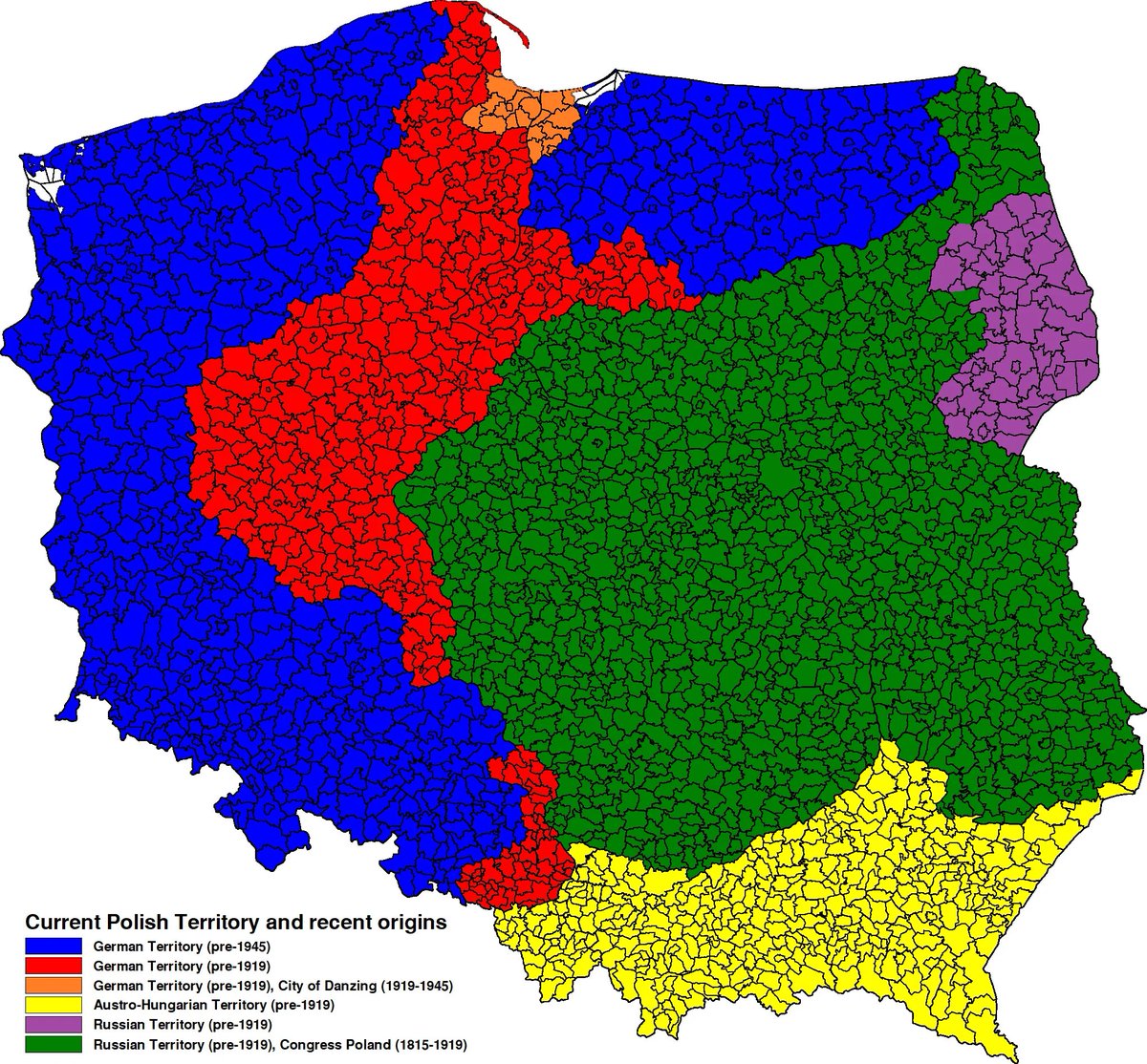
11. Well, that is the old Prussian territory that Poland gained in 1918 (the red on this map). It's ethnically Polish but different from the Russian and Austrian parts (which were also ethnically Polish) and from the blue parts, which were for the most part German.
12. You can see that phantom territory in many maps. Here are farmers with only primary education or lower in 1996. The combination of Prussian schools before 1914 and Polish schools after made even the poorest classes of people more educated than elsewhere.

13. Let's zoom out a bit. This is a map of out-of-wedlock births in Europe. Notice that white area in Poland, Western Belarus and Ukraine and even part of Lithuania?
This is the area of the Second Polish Republic (1918-39).
This is the area of the Second Polish Republic (1918-39).

14. You can see both the 1914 and 1939 borders on this set of maps, showing the age of inhabited buildings in Poland in 2011.

15. They also show on the most-popular map I've ever made - the map of who brings you gifts on Christmas.
There are actually way more phantom borders here. For example Upper Silesia, where I'm from, used to be a part of Austria for a while, which is why we get Christkind.
There are actually way more phantom borders here. For example Upper Silesia, where I'm from, used to be a part of Austria for a while, which is why we get Christkind.

16. Then it got under Germany and retained it. By comparison, Greater Poland, which also was under German rule but never under Austrian rule, adopted the Weihnachtzeitmann.
This is the end of this thread. As a bonus, enjoy this map showing how long a land was under Polish rule.
This is the end of this thread. As a bonus, enjoy this map showing how long a land was under Polish rule.

PS. And if you've enjoyed this thread, take a look on another thread I did about how the Catholic church aligned itself with Law and Justice party and lost an entire generation in Poland
https://twitter.com/sheemawn/status/1714864420076274165
• • •
Missing some Tweet in this thread? You can try to
force a refresh