🧵Now that day has broken, and we're getting better evidence, I'm willing to share some PRELIMINARY thoughts on the al-Ahli hospital explosion. The photos of the scene are, to me, not consistent with an airstrike and are not consistent with claims that 500+ people were killed.


First, I should mention that this thread isn't a forensic or expert investigation, I'm just sharing what I see and what I've seen previously. Nor am I attributing one way or another. Nor does this negate the countless civilians killed in Israel's campaign.
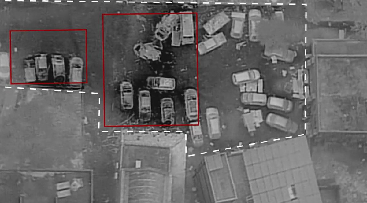
Photos of the aftermath show that the vast majority of the damage is from fire. Only 3 cars show any clear sign of kinnetic/structural damage. And for two of them, the general structure remains intact - despite clear damage. 

This lack of structural damage to most cars is also clear in the IDF released drone fotage from less than 2hr after the explosion. Again these only show 3 cars with structural damage, and cars more than around 10-15m away appearing mostly undamaged. 

Footage from ground level this morning shows essentially no crater. And very little damage to the building around 20m away from the impact site.


Next I want to highlight one of the things that the IDF claimed showing damage to roofs of hospital buildings around 30-45m away from the impact site. This would be consistent with an object that broke apart in midair, though I wouldn't view this point as conclusively as others.. 

Namely because the 'before' image is from two days prior to the strike, I believe there were reports of the hospital being minorly damaged in strikes during that period so it is possible that the roof damage is not from the same time as the explosion.
But all in all, the damage we see is consistent with a small impact, with a lot of fuel accelerant that likely caused most of the fire damage, and very little (within a very narrow radius) structural damage.
Compare the damage from photos of rocket impacts in Ashkelon from last weekend. The only real difference is that this explosion appears to have involved more accelerant (which would track with reporting that this barrage was aimed at Tel Aviv).


Same lack of significant cratering, same structural damage/radius to parked cars. Similar in just a lot of ways.
Compare this to airstrikes in Gaza which tend to leave a much larger crater and cause a lot more damage, they also almost always leave big deposits of concrete dust after striking a structure, though the construction of this particular hospital could be different. 

I spent a while looking for an individual IAF airstrike on a singular structure, rather than broad/widespread devestation, and found this in lower resolution imagery. It shows the crater, but also the concrete dust cloud deposits that are around 30m from the impact site. 

Also see this to show the scale of the structural damage and concrete dust.
https://twitter.com/Nrg8000/status/1712621699571818618
Next I want to address the claimed casualty count of 500+ killed, which seems widely inconsistent with the damage we can see. I am not doubting that civilians were killed, videos show the bodies collected in the hospital courtyard and I have no reason to doubt that.
It is also more than possible that there were many people in the area. And the casualties could be quite high, especially if people were out in the open and there was falling, burning fuel.
But 500's incredibly high number, honestly implausible. Overlaying the area of damage on Google Earth - keep in mind this is mostly from burning cars NOT the explosion - it is 228m2.
This is that sort of crowd density (assuming there were no survivors which is also implausible).


This is that sort of crowd density (assuming there were no survivors which is also implausible).


In July 2016 a truck bomb in Baghdad killed ~350, this is the damage it did.
In Oct 2017, a truck bomb in Mogadishu killed 500+, this is the damage it did.
In Oct 2022, a truck bomb in Mogadishu killed ~125, this is the damage it did.
Compare any of that to the above.


In Oct 2017, a truck bomb in Mogadishu killed 500+, this is the damage it did.
In Oct 2022, a truck bomb in Mogadishu killed ~125, this is the damage it did.
Compare any of that to the above.


Someone very kindly sent me higher resolution imagery of the airstrike impact I was talking about in this tweet. This demonstrates all the points I Was trying to make about the damage of IAF airstrikes.

https://twitter.com/Nrg8000/status/1714549827441406009

None of this absolves the IDF from the countless civilians it has killed in this aerial campaign. There is no excuse for the degree of civilian casualties that the IDF considers acceptable, nor of the siege tactics. And no one can deny the extent of devestation brought to Gaza.
But it seems extremely clear to me, that much (most (all)) of the initial reporting and discussion surrounding this explosion was inaccurate. The discourse and the reaction has quickly overtaken the facts and now it seems that the facts don't really matter.
It has also put me in the unenviable position of not being able to fully trust the numbers that come out of the Gazan Health Ministry, considering they are the only source providing numerical figures of the unquestionably numerous casualties in Gaza.
There is also this claimed audio intercept of communications between Hamas members in the area. I've tried to make the above thread accurate without relying on claims from the IDF which are often inaccurate, but this is still worth noting.
https://twitter.com/IDF/status/1714548529538953637
More on the ground footage of the scene, also showing the lack of a crater.

https://twitter.com/clashreport/status/1714561108713836904

Photos being released of the aftermath today shows that the grassy area to the West of the parking lot was full of civilians (blue in the map), a crowd here when the explosion happened could cause considerable civilian death, especially if there was falling fuel.


There is also photos showing damage nearer to the front of the hospital. This wider damage suggests there may have been a larger debris field which coudlve caused damage and casualties.
Despite this being a mass-casualty event, I still highly doubt the 500+ claim.


Despite this being a mass-casualty event, I still highly doubt the 500+ claim.


This video is the first that shows an impact crater. Once again, inconsistent with an airstrike. This crater is ~10m away (& closer to the civilian camp) from where I initially thought the impact was.


https://twitter.com/EliotHiggins/status/1714574904840888549


Given a car around 10m away from this impact was flipped by the explosion (which I thought would have meant an almost direct hit) this could further indicate a projectile that broke up mid-air. But this is not something im confident in calling, would love to hear from an expert.
This video looks pretty conclusive too, showing the hospital blast directly underneath rocket trajectories.
H/t @manniefabian
H/t @manniefabian
https://twitter.com/N12News/status/1714579143491207264
@manniefabian One other thing I will note, is that it is particularly sneaky of the IDF to release the thermal drone imagery in a way that just barely cuts out the small impact crater (around where the red circle would be). No idea if they did this deliberately, but it certainly does not help. 

But generally when militaries just crop out a very relevant piece of evidence from their media releases... it's not great.
See this perennial example.
bellingcat.com/news/mena/2015…
See this perennial example.
bellingcat.com/news/mena/2015…
There's a few threads gaining some traction that claim to prove an Israeli jet struck the hospital. They're wrong. Their geolocation is wrong & their timing is wrong.
Here's a thread where I step-by-step refute their claims.
Here's a thread where I step-by-step refute their claims.
https://twitter.com/Nrg8000/status/1714648344365302017
The Channel 12 video showing the missiles being fired and the explosion in the hospital under the path can be geolocated to a housing complex in the NW of Netivot (31.439841, 34.573214) and the bearing to the blast matches perfectly with the Hospital


Also, the bearing of the rocket fire (from the very left-hand-edge of the 2nd story of the background home) points almost exactly towards the site identified from radar readouts by the IDF as the launch site for the rockets. 

It's now been 24hr since the explosion at the hospital. Despite numerous photographers/reporters at the site today, there arent images of missile/rocket fragments. Given they would conclusively show who is responsible (& given who secures the site), no photos of them is notable.
Here is a higher resolution image of the blast site via @BBCNews' verification team which came to many of the same conclusions as this thread. bbc.com/news/technolog…


• • •
Missing some Tweet in this thread? You can try to
force a refresh


