Nathan Ruser Profile picture
Oct 18, 2023 16 tweets 7 min read Read on X
This thread is going around attempting to show 'proof' that Israel was responsible for the explosion at the Gazan hospital.

It does not, the video is from a totally different incident, hour after the hospital blast and shows a strike 1.5-4km away. I'll explain why.
First, I want to preface this analysis by pointing out that this account has been spreading disinformation and denialism about Ukraine for over a year. They have never acted in good faith, but for the people sharing his crap without knowing this I'll refute it at face value.

Image
Image
Image
The argument is immediately refutable since the same camera did film the explosion at the hospital, in footage youve probably seen, an hour earlier, at 6:59pm.
The time stamp in the video he shared is an hour later, at 7:59pm.
Image
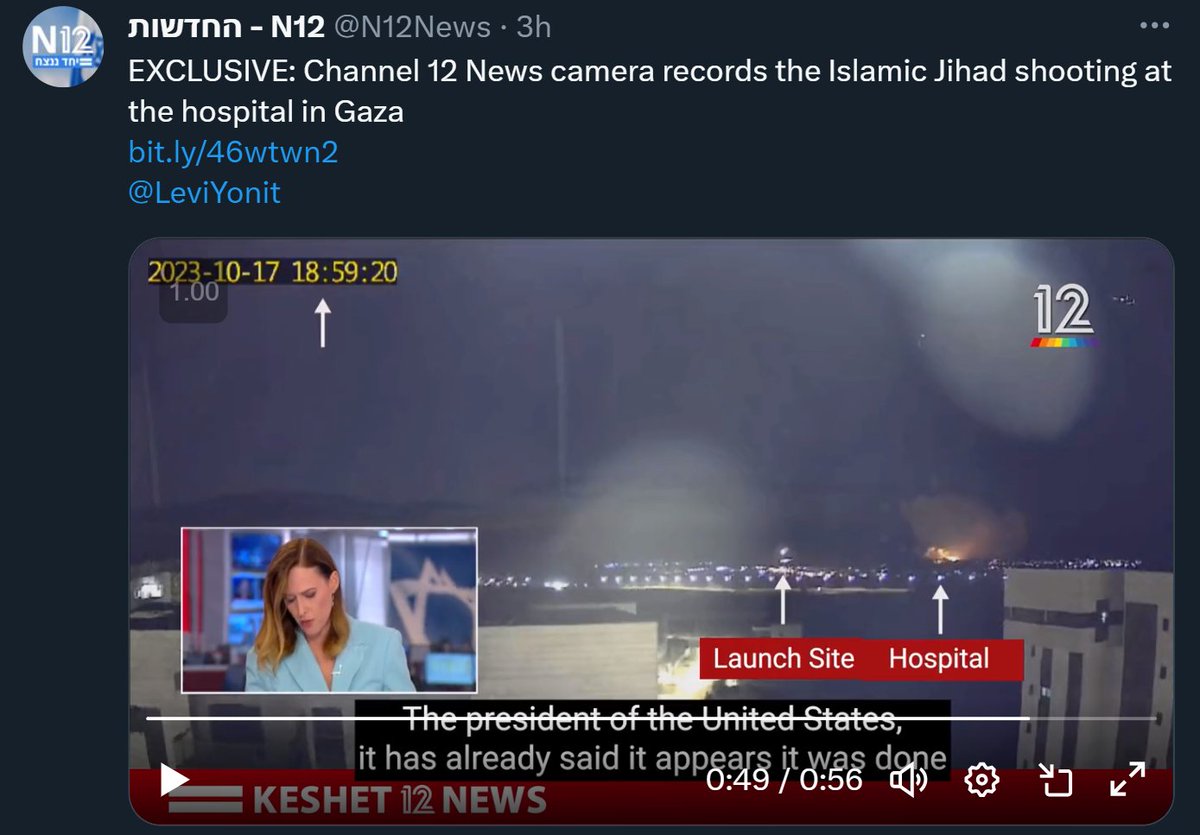
Note that the IDF claims the explosion happened at 6:59pm (and claimed that before this video was released), the first open reports of the blast were around 7:15-7:20pm, all well before the video this jabroni is sharing, which is literally timestamped 7:59pm.
He stupidly claims that the reason for this is that the camera's timestamp was off by an hour.

Not impossible in its own right, but very stupid here because if the footage that says 6:59 was actually shot at 5:59, it'd be daylight.
Image
He then also tried to geolocate the video, and gets it wrong.

The cone of view he's claiming the camera can show isn't even pointing at Gaza City. It literally would not show the hospital, and the rocket fire would be shooting from Israel (into Israel)
Image
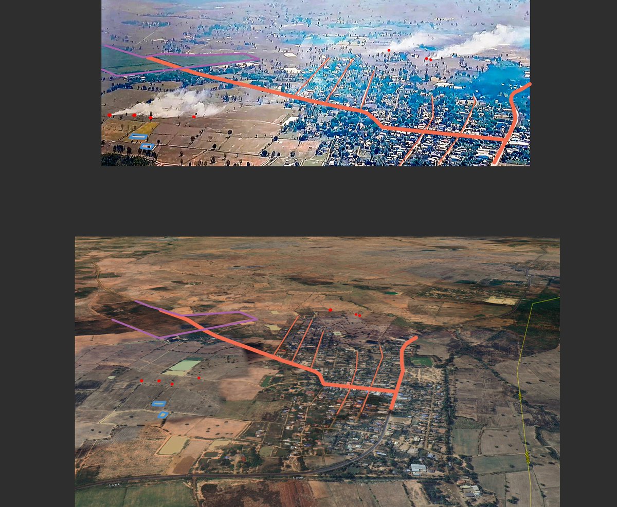
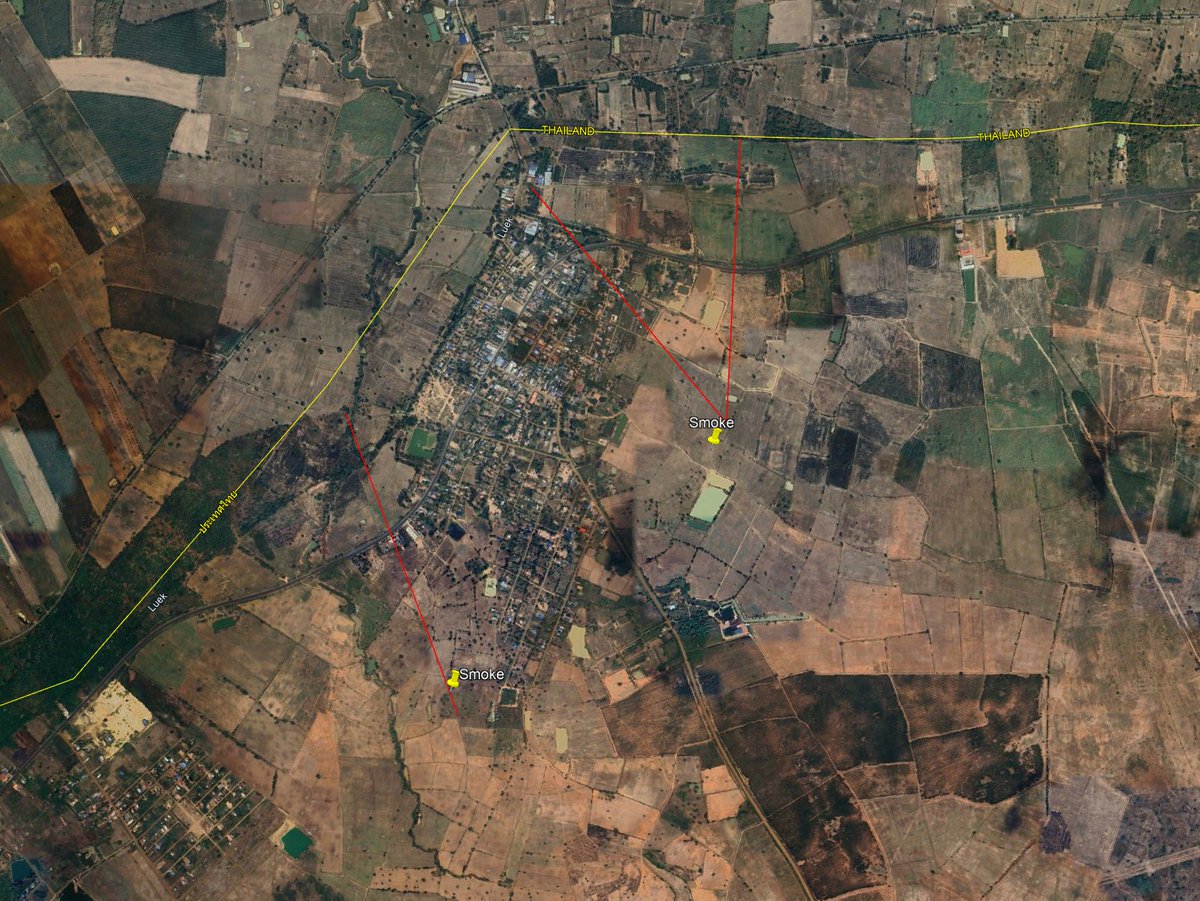
Morever, let's look at the picture and geolocation side-by-side. Even if it was this building, he's looking at the wrong side of it. The buildings he is claiming it shows also has a column of windows between the black decal and the corner, which the footage shows isnt the case.

Image
Image
Image
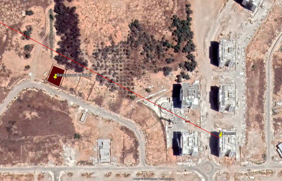
In fairness, the geolocation is only off by about 200m. But it is facing the entirely wrong direction. The camera was actually at 31.439871, 34.573232 and (obviously) facing West towards Gaza and not north towards Ashkelon. Image
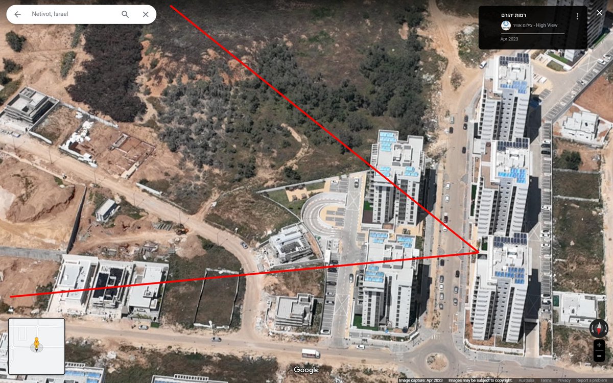
This can also be demonstrated by the road and building in the bakground, along with the facade of the closest building. Image
So now we know the real location the video was filmed from, we can look at the angles. The bearing from the camera to the hospital is around 304°. More notably, it is just to the left of the corner of the right-most close building. Exactly where it appears in the 6:59 video.
Image
Image
Meanwhile in the 7:59 video, the blast is around 1/3 of the way between that background building and the tower. At a bearing of around 297.5°. If we draw these bearings out as far as Gaza, it's obvious that the 7:59pm explosion we see is kilometres away from the hospital.

Image
Image
Image
This is an example of the damage pseudo-OSINT analysis can do. Poor techniques used to 'confirm' an already-made-up-mind results in incorrect geolocation, incorrect chronolocation and completely wrong conclusions. And ends up being ammo for denialists and others.
FYI they deleted the tweet saying that the camera's clock was off by an hour, because that would mean the night-time footage wouldve been filmed before sunset. but here it is for posterity's sake. Image
Whoops, the geolocation tweet is gone too... Image
Also, the bearing towards the rocket fire in the 6:59pm video (above the left-hand-side of the 2nd-storey in the home in the background) gives a line that points almost directly at the IDF-claimed, radar detected, rocket launch site. Again proving this is video of that incident. Image
The whole thread has been nuked now since it was obviously wrong, but a number of other serial spreaders of disinformation are still spreading the video, so just keep an eye out.

• • •

Missing some Tweet in this thread? You can try to force a refresh
 

Keep Current with Nathan Ruser

Nathan Ruser Profile picture

Stay in touch and get notified when new unrolls are available from this author!

Read all threads

This Thread may be Removed Anytime!

PDF

Twitter may remove this content at anytime! Save it as PDF for later use!

Try unrolling a thread yourself!

how to unroll video
  1. Follow @ThreadReaderApp to mention us!

  2. From a Twitter thread mention us with a keyword "unroll"
@threadreaderapp unroll

Practice here first or read more on our help page!

More from @Nrg8000

Dec 14
As the man who disarmed a terrorist shooter in Bondi is named as Ahmed El Ahmad, a Muslim name, there is already AI-generated disinformation falsely claiming the hero was a Sydney-born local called "Edward Crabtree", with an entire AI-generated backstory.
archive.is/K5eSIImage
Image
The entire website is built around this disinformation (try clicking any of the related articles) and falsely attributes quotes to the NSW Police Commissioner, the Australian Prime Minister, the made-up Crabtree and several others.
Meanwhile, people are already trying to 'community note' posts about al-Ahmad. The person who wrote this community note has only previously written in Brazilian Portuguese, generally forwarding right-wing talking points. Image
Read 5 tweets
Dec 8
A 🧵(ongoing) of geolocations from recent escalations on the Thai-Cambodia border.
Firstly, Thailand has claimed it has launched a ground operation into Sa Kaeo, near Chouk Cheay / Ban Nong Chan. Smoke rounds are around 1km beyond the previous forward deployment of Thai troops.
13.766103, 102.702367

google.com/maps/place/13%…

nationthailand.com/news/asean/400…Image
Image
x.com/Thenationth/st…
This video shows an airstrike on a target (former Casino / possible scam centre) at Chong An Ma, at 14.38374, 104.96569
google.com/maps/place/14%… Image

These screengrabs (geolocated first by @RoadtoMars9 ) show Thai infantry fighting vehicles advancing past the de-facto barbed wire border, presumably at least towards the Thai interpretation of the border (purple line)
13.8174, 102.7369 Image
Read 38 tweets
Jul 25
🧵A detailed timeline on escalations in the lead-up to yesterday's clashes between Thailand and Cambodia.
Much of the escalation seems to stem from Cambodia, with their troops fortifying many sectors before the May 28 clashes and surging strategic assets immediately after.
🗺️ - heatmap of Cambodian military developments prior to July 24th.Image
2025-02-13. The immediate tensions seem to originate from an incident on February 13, when a group of Cambodian soldiers escorted civilians to visit an ancient temple. The group reportedly sang the Cambodian national anthem and was later stopped by Thai security officials. Image
2025-02-17. Defence Minister Phumtham Wechayachai expressed concern over the recent provocative incident involving Cambodian troops in Ta Muen Thom, stating that he does not want the incident to escalate into a conflict.
Read 49 tweets
Jun 10
The craziest thing is that the LA protests are remarkably normal, dare I say pedestrian. Theres no significant or widespread destruction, barely any meaningful resistance to law enforcement.

It's so transparently obvious that the Trump admin wants to fabricate a crisis.
There is absolutely zero tactical or strategic need for any federal support to control what we've seen this weekend. Yet the admin has been able to completely dominate and distort the conversation with barely any pushback from the democratic establishment or even the media.
By the way, when I say 'barely any meaningful resistance' I don't mean no skirmishes, I mean that at NO point have the police not been able to quickly and effectively perform whatever crowd control action they deem necessary.
Which is absolutely credit to the protesters.
Read 12 tweets
May 7
🧵Geolocations of ALL sites that the Indian Army has claimed to have hit in Pakistan and Kashmir.
1. Masjid Syedna Bilal/Hazrat Bilal
34.385846°N 73.456974°E
It appears to have been a direct hit, according to after-strike ground photos.
google.com/maps/place/34%…Image
Image
2. Reported training camp in Gulpur, Kotli
33.402328°N 73.876957°E
No post-strike imagery yet.
google.com/maps/place/33%…Image
3. Masjid Ahl-e-Hadis in Barnala, Bhimber.
32.867802°N 74.256469°E

Quadcopter-dropped munition appear to miss the target building and strike a courtyard around 50m away. google.com/maps/place/32%…Image
Image
Read 14 tweets
Mar 8
There's a horrendous amount of violence happening over the past few days in Syria, and a tremendous amount of uncertainty in numbers, details & actors. Yet it's astounding just how few people (including mainstream journalists) are engaging with these incidents in any good faith.
So many people are visibly giddy at the idea that the new Syrian government is committing atrocities. And as a result, absolutely misrepresenting the violence that is occurring. It's pulling in the pro-SDF crowd (biji!biji!) the Assadist crowd (counter-revolution!), the pro-Israel crowd (only the IDF can protect minorities!), the idiot Westerners (Assad was the thin blue line!) and even mainstream journalism (finally some spice to report).

And as a result, its the most counter-productive information environment I've seen around Syria since the chemical attack information ops.
It's imperative we find the details of these atrocities, who is involved and hold them accountable. It's crucial this is prevented from becoming a wider sectarian conflict.
And it's wild that most reporting and commentary is acting as a barrier to this, not a help.
Read 4 tweets

Did Thread Reader help you today?

Support us! We are indie developers!


This site is made by just two indie developers on a laptop doing marketing, support and development! Read more about the story.

Become a Premium Member ($3/month or $30/year) and get exclusive features!

Become Premium

Don't want to be a Premium member but still want to support us?

Make a small donation by buying us coffee ($5) or help with server cost ($10)

Donate via Paypal

Or Donate anonymously using crypto!

Ethereum

0xfe58350B80634f60Fa6Dc149a72b4DFbc17D341E copy

Bitcoin

3ATGMxNzCUFzxpMCHL5sWSt4DVtS8UqXpi copy

Thank you for your support!

Follow Us!

:(