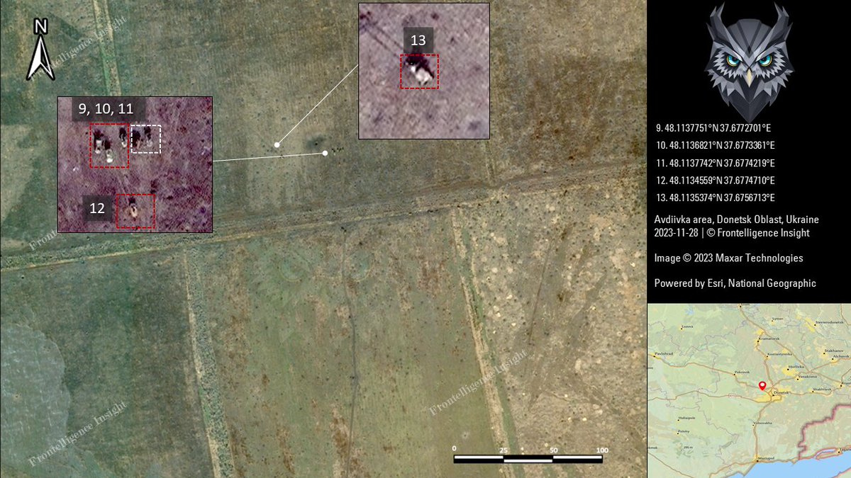
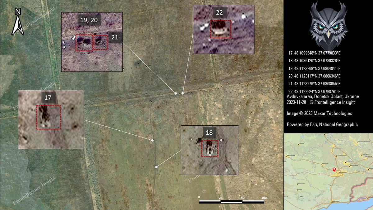
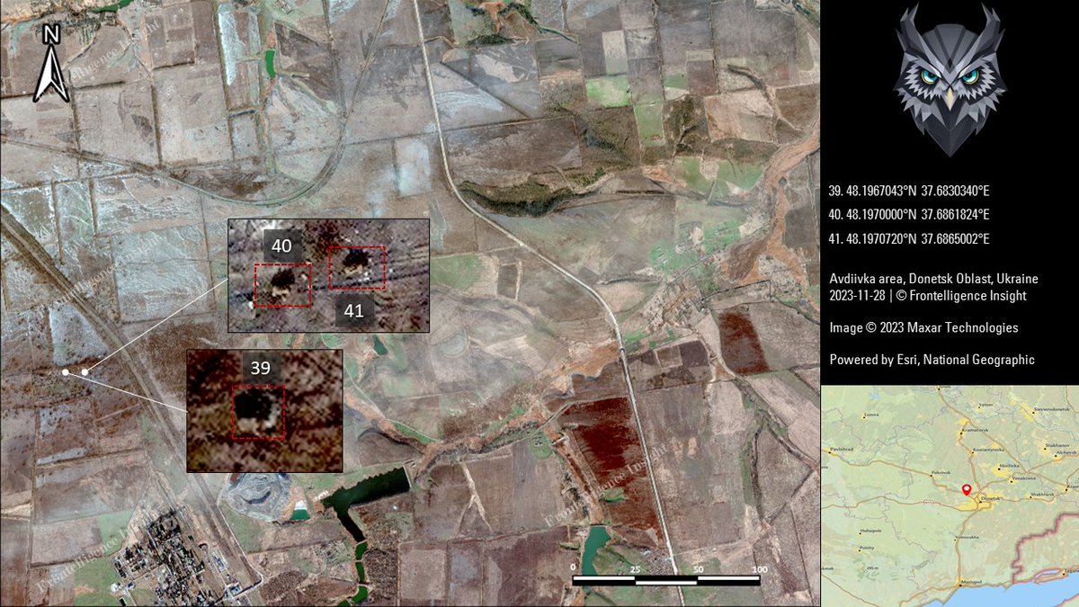
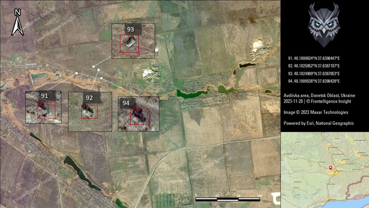
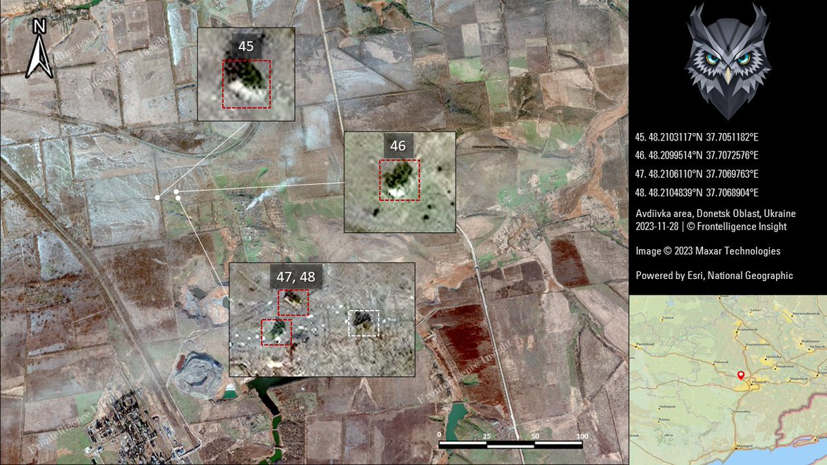
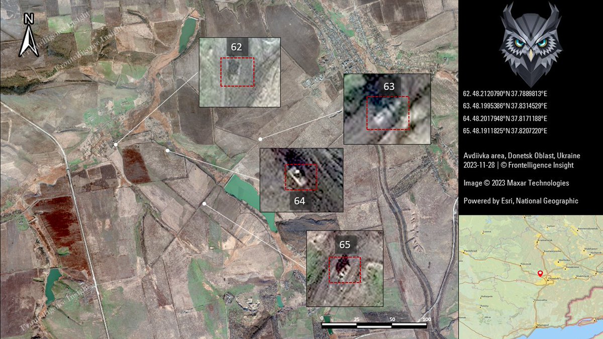
Frontelligence Insight team, upon a thorough examination of multiple satellite shots spanning from October 10th to November 28th, has identified over 211 destroyed or damaged and abandoned Russian vehicles in the vicinity of Avdiivka. 🧵Thread:
2/ Our initial report included over 109 vehicles between October 10th and October 20th, excluding the area west of Vodyane. This time, we expanded our coverage to include the entire area until November 28th, 2023, bringing the total number to 211.
3/ Losses identified in Part 1 or occurring before October 10th—the start of the assault—are marked with white squares. Ukrainian losses are excluded from this report, focusing on Russian losses, though we couldn't identify more than 7.
4/ This number surpasses Russian losses in any other single battle, including Vuhledar, marking it the most devastating battle for Russian forces in terms of vehicle losses. The primary categories of losses include tanks, BMPs, BTRs, MTLB, some IMVs, a couple of trucks, and MLRS
5/ Notably, not all confirmed FPV drone hits led to observable destroyed vehicles in satellite imagery. Some vehicles may remain operational or get evacuated for repairs. An FPV drone hit doesn't always indicate a vehicle loss.
6/ Around 50% of these losses occurred in the first three weeks of the offensive, with occasional peaks in the October-December period. This aligns with our earlier reports about a shift towards infantry assaults instead of massive mechanized troops.
7/ We excluded several locations recorded on videos where Russian vehicles were destroyed due to the extensive explosions. However, on the imagery, there was nothing left to identify as a vehicle, other than a scorch mark and crater.
8/ To enhance accuracy, we compared imagery from September and October to exclude vehicles destroyed before October 10th and those included in the previous report. Errors and misidentifications might still exist, but they are estimated to be no more than 12.75%
9/ The total number of losses would amount to approximately slightly over the complete annihilation of 5 battalions. This represents significant losses in both equipment and personnel, considering the achieved results.
10/ The complete list of losses with images can be found on the website linked in my bio. (I am not including the link in the thread as it significantly degrades the visibility of this thread and doesn't show up in the timeline.)
11/ Our team is working on multiple projects, including tracking the expansion of Russian military infrastructure. Considering that we do not have stable financing, please consider the BuyMeaCoffee option linked in my bio to support us, given the very limited resources we have.
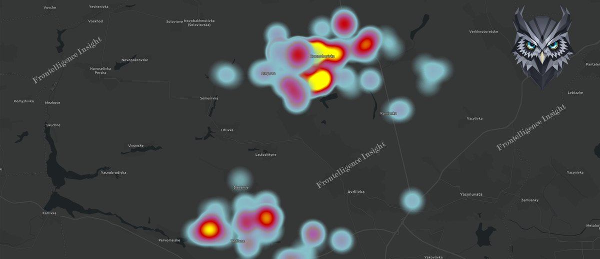
12/ Our teams utilized geolocated data to visually map Russian vehicle losses between October 10th and November 28th, aiding in visualizing the battle for Avdiivka and identifying locations with the highest concentration and number of vehicle losses.
13/ These materials were prepared by the Frontelligence Insight team, with assistance from volunteers and with OSINT geolocated materials: @naalsio26 , @Danspiun , @AndrewPerpetua , and @GeoConfirmed
• • •
Missing some Tweet in this thread? You can try to
force a refresh
While public attention was on airfields in Luhansk and Berdyans'k, russians set up secret helicopter bases and FARPs in various locations.
This was initially exclusive to paid subscribers, but I am now releasing it, especially in light of the recent SBU strike in the region.
2/ In November, as Ukrainian forces advanced towards Kherson, the Russian military opted to move their helicopters from the Chaplynka Airdrome to more secure inland locations, including a fenced beach resort in Arabat Split near Crimea.
3/ In this image, 20 helicopter pads are visible, some occupied by Russian helicopters like Mi-24, Mi-8, Ka-52, and possibly Mi-28. Notably, the site is within the beach resort "Volna," enclosed by a fence.
While exploring recent developments in one of Russia's most secretive zones, our team “Frontelligence Insight” has spotted facility expansions and new constructions on the grounds of Sarov, formerly known as Arzamas-16, the birthplace of the Soviet Nuclear Project.
🧵Thread:
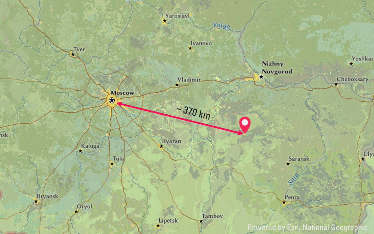
2/ Nestled in the Mordovsky Nature Reserve, a seemingly serene forest 370 km from Moscow houses a complex of secret facilities. With a history dating back to the Soviet era, it played a pivotal role in the Soviet nuclear program and the production of nuclear weapons.
3/ Sarov, formerly Arzamas-16, is a closed city with restricted access, requiring specific authorization for residency or visits. It hosts research and production facilities linked to the military-industrial complex, focusing on nuclear warhead development and related projects.
I'm disappointed by the misleading article from NYT with a sensationalist headline, inaccurately claiming "In less than two months, more than twice as many women and children have been reported killed in Gaza than in Ukraine after two years of war." Here's why it's inaccurate🧵:
2/ The article asserts that "More than twice as many women and children have already been reported killed in Gaza than in Ukraine after almost two years of Russian attacks, according to United Nations estimates. To verify this claim, I checked UN-provided numbers
3/ Firstly, the given number is not verified; it's a claim from the Gaza Health Ministry, provided to the UN. This is markedly different from UN-verified deaths in Ukraine, as one is a claim from an involved party, while the other represents independently verified casualties.
Despite dense cloud cover blocking satellite, drone, and optical surveillance of the Avdiivka battlefield, our team continued the analysis using Synthetic Aperture Radar (SAR) systems. Here is what we learned about the current situation. 🧵Thread:
2/ Before we move further, let's clarify what Synthetic Aperture Radar (SAR) is. It's a technology that employs radar to generate images of the Earth's surface. By capturing and processing reflected waves, SAR provides detailed imagery regardless of weather conditions or daylight
3/
We combined SAR data with on-the-ground testimonials and open-source video materials to gain comprehensive insights.
Some Key Observations
- Vehicle Reduction: In contrast to the initial month of assaults, russian forces are employing fewer vehicles in smaller numbers.
Amid the ongoing debate about the number of operational Ka-52 helicopters on the frontlines, I've analyzed and compiled imagery of bases used for helicopter operations by the Russians. The findings are summarized in this 🧵Thread:
1/
2/ Based on acquired Maxar images from November 1st, the Taganrog airbase hosted at least 4 operational Ka-52 helicopters on its tarmac. The surrounding activity indicates their use, a fact further supported by their absence in earlier shots.
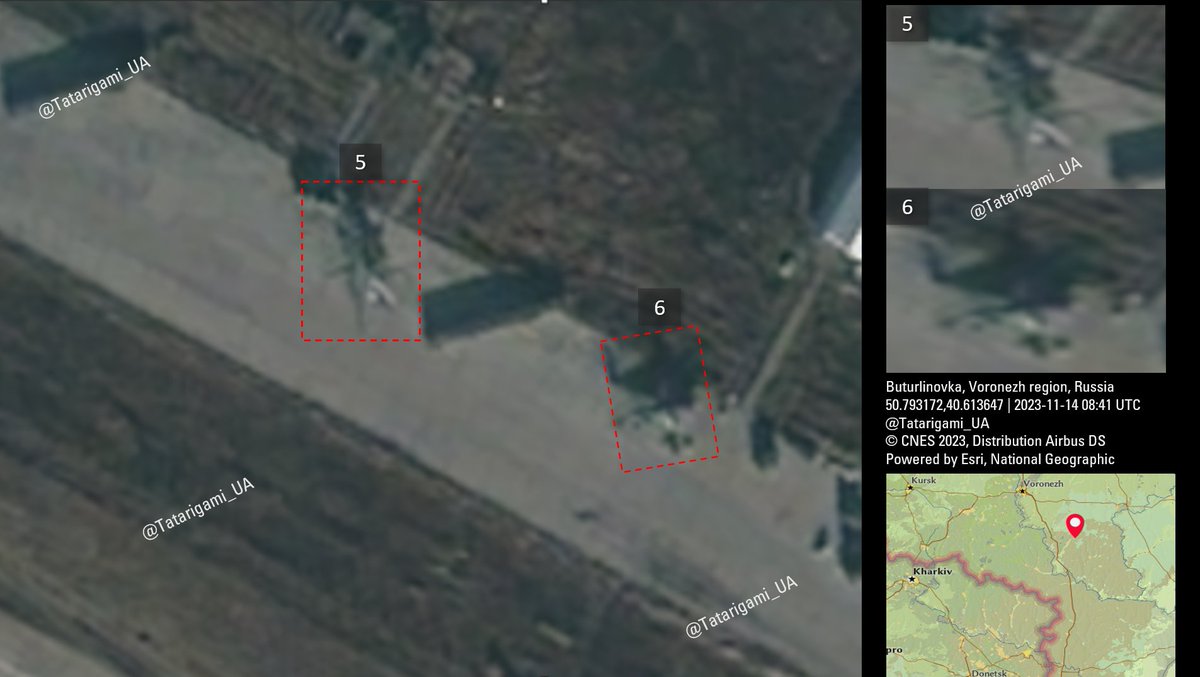
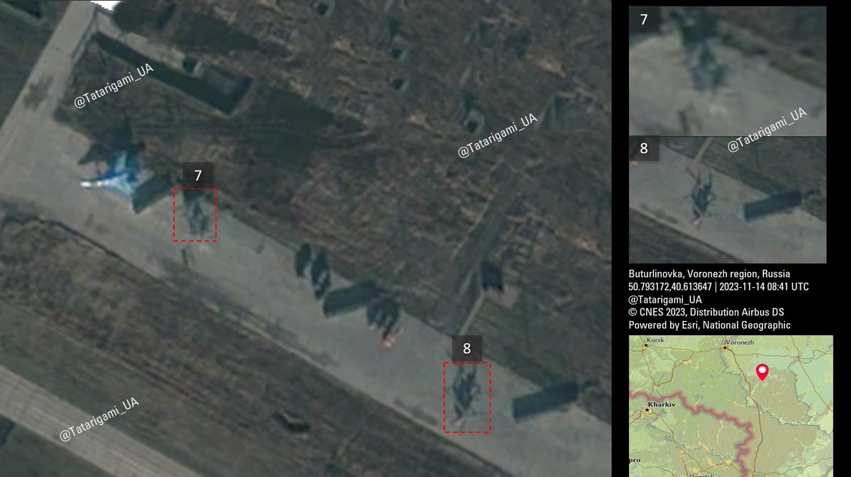
3/ The Buturlinovka Airbase accommodates a minimum of 5 Ka-52 helicopters. Although Helicopter #7 is not distinctly visible in this image, the next image includes a slightly older photo of the same helicopter at the same location for clarity.
BBC published an article in Russian titled "Does it make sense for Ukraine to fight for Avdiivka?" In this article, several experts argue that Avdiivka lacks military significance. I disagree with this assessment, finding it misleading. Here's why. 🧵Thread:
1/
2/ While I agree that the assault on Avdiivka likely has political reasons, as I discussed on the day the assault started, focusing solely on political aspects is not only inaccurate but also dangerous.
3/ The article states, "Most experts agree that it has exclusively political, not military, significance for the Kremlin."
I strongly disagree with it - Avdiivka has played a key military role in Donetsk since 2014.