Why is Madrid the capital of Spain?
Madrid is quite unique:
• No river
• Very recent
• Tiny when it became a capital
So why?
Madrid is quite unique:
• No river
• Very recent
• Tiny when it became a capital
So why?

These are the rivers of other big European cities & capitals: huge and calm. Why?
Because rivers allowed:
• Drinking
• Irrigation ➡️ food ➡️ population
• Trade: Transport is much cheaper than on roads, so much more trade and wealth
Because rivers allowed:
• Drinking
• Irrigation ➡️ food ➡️ population
• Trade: Transport is much cheaper than on roads, so much more trade and wealth

You can see the importance of rivers by the population density in France: it follows the course of rivers! You can tell the confluence of big rivers because they host the biggest population centers—natural markets to trade across the meeting rivers
Compare with Madrid's main river
Do you know its name? No, because it's puny
It's weak. An affront on capital rivers. A feeble stream
Low bridges. Full of sandbars. Why? No point in clearing them. The only thing that navigates the Manzanares is its inferiority complex
Do you know its name? No, because it's puny
It's weak. An affront on capital rivers. A feeble stream
Low bridges. Full of sandbars. Why? No point in clearing them. The only thing that navigates the Manzanares is its inferiority complex

If Madrid had been blessed with a huge river, it would have been a huge city in ancient times. But no. In fact, it's a very recent city
Compare its founding with that of other capitals of countries occupied by the Romans. Most are 2k+ y old. Madrid? Barely 1k y old
Compare its founding with that of other capitals of countries occupied by the Romans. Most are 2k+ y old. Madrid? Barely 1k y old

When it was selected as capital, it wasn't the 1st, or the 2nd, or even the 3rd biggest city in Spain. It was the 10th! Barely over 10k people. A small town!
Back then, most capitals were the biggest, most powerful, best placed city. Why not in Spain?
Back then, most capitals were the biggest, most powerful, best placed city. Why not in Spain?

Blame this guy
Philip II of Spain—who also gave name to the Philippines. Until the 1560s, Spain had an itinerant court. He wanted to fix it in a city. Where?
Philip II of Spain—who also gave name to the Philippines. Until the 1560s, Spain had an itinerant court. He wanted to fix it in a city. Where?

He had to deal with 2 realities. One was his empire: He needed a capital that was close enough to everything. That was Spain, which was also among the richest parts of his empire.

So he wanted a capital in Spain
This is Spain
What do you notice?
It's criss-crossed with mountain ranges. This has serious consequences
This is Spain
What do you notice?
It's criss-crossed with mountain ranges. This has serious consequences

• Spain has a lot of rivers separated from each other by these mountain ranges. This means they're smaller than its Northern Europe equivalents
• Because they go through all these mountains, they aren't navigable*. They couldn't be used much for trade
So no big central city
• Because they go through all these mountains, they aren't navigable*. They couldn't be used much for trade
So no big central city

It also means there are few plains. The few on the coast all developed big populations since Roman times. Barcelona, Valencia, Huelva, Cadiz... All predate the Roman!
This means Spain was (and is) made of islands of coastal population separated by mountains
This means Spain was (and is) made of islands of coastal population separated by mountains
Another thing to notice: It's surrounded by coasts, but each coast had its own pbms:
• Mediterranean: Deal with the colonies in Italy / Greece and fend off Muslim attacks
• Southwest: Deal with Spain's American colonies
• North: Deal with British attacks & Flemish colonies
• Mediterranean: Deal with the colonies in Italy / Greece and fend off Muslim attacks
• Southwest: Deal with Spain's American colonies
• North: Deal with British attacks & Flemish colonies

Then there are the 2 central plateaux ("mesetas") and the Ebro Valley.
The king had to find a place that connected them all as best as possible.
I mentioned before the king had an itinerant court until then. This was the reason: Too many disconnected power centers
The king had to find a place that connected them all as best as possible.
I mentioned before the king had an itinerant court until then. This was the reason: Too many disconnected power centers

So what was the best connected place in the country at the time?
The red areas in the map below. Noticve they include Madrid and Toledo—which was one of the biggest and most powerful cities at the time.
So why not Toledo as a capital?
The red areas in the map below. Noticve they include Madrid and Toledo—which was one of the biggest and most powerful cities at the time.
So why not Toledo as a capital?

This is Toledo. Majestic, on a hill surrounded by the Tajo river
But:
• Streets are small, which is not ideal for travel with your court—and your personal guard
• You can’t grow the city much further
• You can’t determine its urbanism
But:
• Streets are small, which is not ideal for travel with your court—and your personal guard
• You can’t grow the city much further
• You can’t determine its urbanism

And Philip II wanted to build. He had visited his Italian and Flemish possessions and wanted to bring its architecture. This is why he built the Escorial Palace
He wanted to do the same with his new capital
He wanted to do the same with his new capital

Madrid had another benefit: It had a power void.
Toledo and Valladolid had noble and religious leaders who could challenge the king
Not Madrid, which was smaller and had recently lost many nobles due to a failed revolt.
The king had confiscated their lands in Madrid
Toledo and Valladolid had noble and religious leaders who could challenge the king
Not Madrid, which was smaller and had recently lost many nobles due to a failed revolt.
The king had confiscated their lands in Madrid

Madrid had other small benefits:
• Built on a defensible position
• Reliable water from the mountain range
• Air from the mountains (back then, they thought they were the cure against recurring epidemics)
• Forests for hunting
So Philip II chose Madrid in 1561
• Built on a defensible position
• Reliable water from the mountain range
• Air from the mountains (back then, they thought they were the cure against recurring epidemics)
• Forests for hunting
So Philip II chose Madrid in 1561
Once capital, the entire communications network had to be rewired to make Madrid more central. That was the point of the capital after all—allow easy access to all the territory.
Notice how so many Roman road paths have been conserved, but the central part is completely new
Notice how so many Roman road paths have been conserved, but the central part is completely new
This happened over the centuries
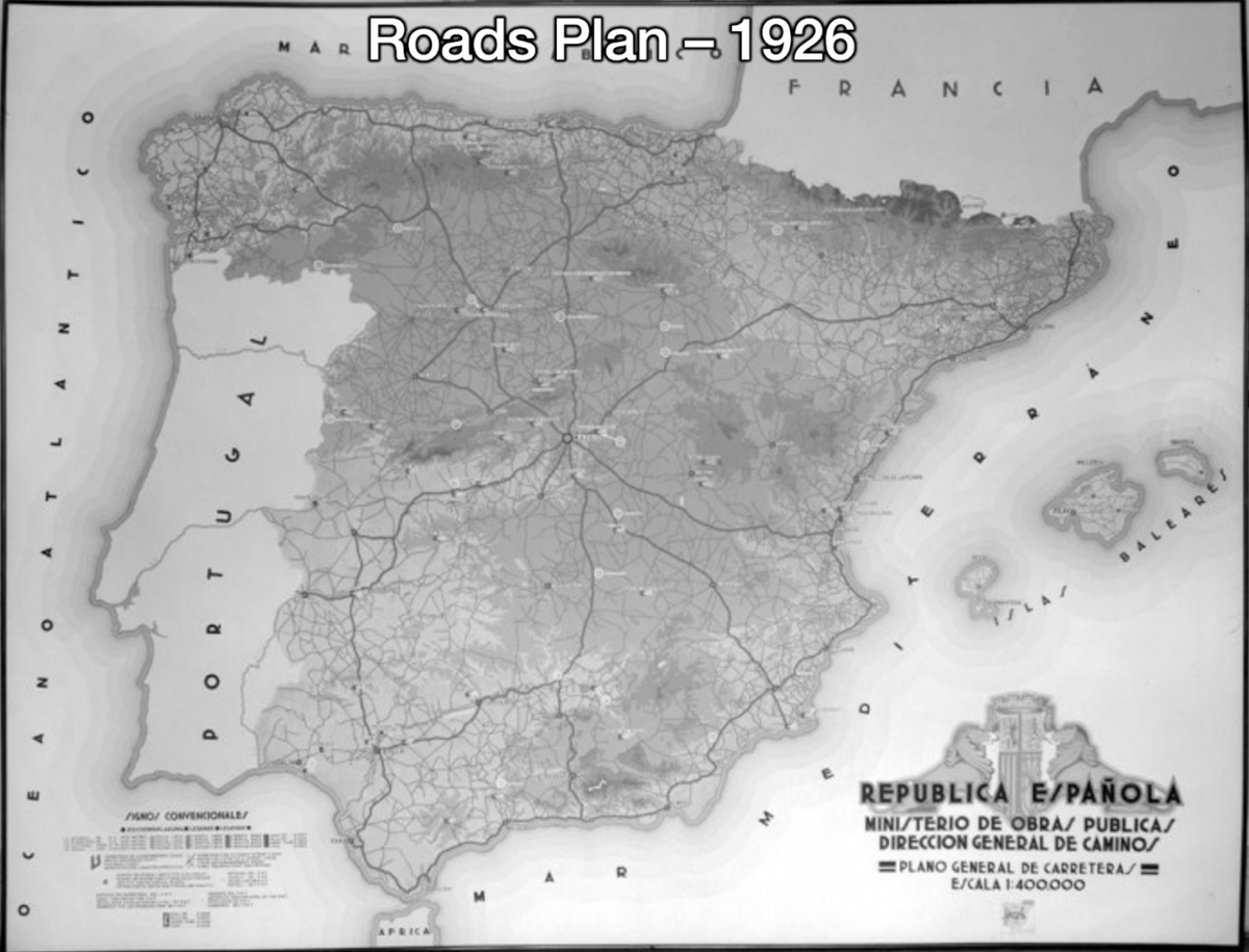
More recently, we can see the roads plan of 1926, the highways plan of 1985, the current railroads... Most cross in Madrid
More recently, we can see the roads plan of 1926, the highways plan of 1985, the current railroads... Most cross in Madrid


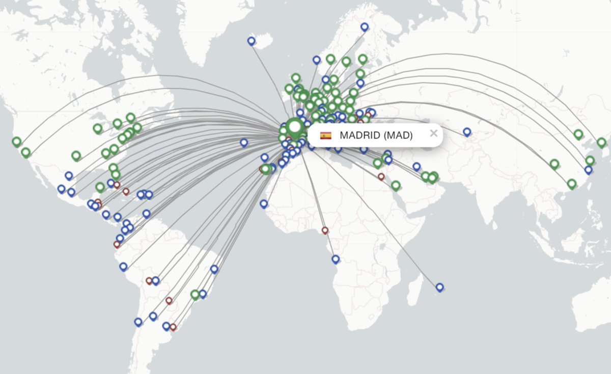
The goal of Madrid's airport was to do the same connecting Spain with the world. It's now the 5th busiest airport in Europe

So Madrid is unique, because its geography had very little to offer—except it was central
But that centrality made it a capital
That centrality gave it infrastructure
That infrastructure made it the most connected place in Spain, hence the biggest market, hence the biggest city
But that centrality made it a capital
That centrality gave it infrastructure
That infrastructure made it the most connected place in Spain, hence the biggest market, hence the biggest city
If you want to know more, I have an upcoming article on Madrid. Sign up to the free newsletter to receive it.
And follow me for more threads like that! One every week/month
unchartedterritories.tomaspueyo.com/subscribe
And follow me for more threads like that! One every week/month
unchartedterritories.tomaspueyo.com/subscribe
• • •
Missing some Tweet in this thread? You can try to
force a refresh