Raj Bhagat P #Mapper4Life Profile picture
Feb 25 15 tweets 6 min read Read on X
Here's a compilation of my #maps which can help you in understanding the #Bengaluru #Water situation a bit better.

Bengaluru is unofficially a hill station which is located nearly a kilometre above sea level. Image
Being in the top of a ridge line, the city is partly within Kaveri watershed and partly in Ponnaiyar (Dakshina Pinakini watershed).
Being on top, water from elsewhere dont flow through Bengaluru but flow outward from the city
Image
Image
Bengaluru right now depends on Kaveri river for water supply. Because of its height, Water is pumped for a height of 1000 feet from the river 100km away from the city Image
But, The Kaveri watershed is one of the most over exploited river system in India. Thousands of water diverting and storage structures make it possible to exploit in both Karnataka and Tamil Nadu which share the river
Image
Image
Most of the water in Kaveri watershed is used for Agricultural purposes.

Basically, the expenditure is pretty high and the income however oscillates.

Which means, except few years of excessive rainfall/flooding in upstream, most of the years the region faces water shortage


Image
Image
Image
Image
And remember, Bengaluru can't demand a lot of water from Kaveri also as only a part of the city is in watershed though the entire city is dependent on it (along with ground water & tankers)
In map, we can notice significant part of BBMP(marked in black) is not in Kaveri watershed Image
But most of the bigger development in Bengaluru is happening outside Kaveri watershed in the South East(ECity), East (Whitefield), and North (Airport)
This unbridled and unbalanced growth has put immense pressure on Bengaluru. Bengaluru is 10x larger than the next city in Karnataka. Increasingly the population and economy is skewed towards Bengaluru with people migrating from all the states & from other districts of Karnataka

Image
Image
Image
In short:
1. Kaveri is over exploited, requires conservation in all sectors (primarily agriculture) by both Karnataka & Tamil Nadu. Any year with average or less than average rainfall would result in drought /watercrisis not just for Bengaluru. This requires research & investment
2. Bengaluru is over grown considering it's geography and it is imperative that the growth across the country and within the state to be diversified to next tier cities and this would require investments in the same directiom
3. Bengaluru can't depend on Kaveri river alone coz of the risk involved. Failure of rainfall upstream last season is leading to the crisis this year. The city hence has to judiciously use the water it has (conserve), utilise the rainfall within city (harvest), & reuse wastewater
Before grilling Bengaluru on social media, please note that these issues of environment (flood, water crisis etc.) arising from poor planning and lack of geographical understanding, exist in most major metros across the country. Bengaluru is just reported better!
It is hence important for us as citizens (of not just Bengaluru), to focus on the processes that govern our planning, the methods through which we execute them, our pattern of growth, awareness etc.
Forgot to add this:
~97% of Indians live at an elevation lower than that of Bengaluru

And if you're at it, here's is my take on the geography of the city and the urban flooding issues it faces as presented in an event hosted by the Bangalore Room

• • •

Missing some Tweet in this thread? You can try to force a refresh
 

Keep Current with Raj Bhagat P #Mapper4Life

Raj Bhagat P #Mapper4Life Profile picture

Stay in touch and get notified when new unrolls are available from this author!

Read all threads

This Thread may be Removed Anytime!

PDF

Twitter may remove this content at anytime! Save it as PDF for later use!

Try unrolling a thread yourself!

how to unroll video
  1. Follow @ThreadReaderApp to mention us!

  2. From a Twitter thread mention us with a keyword "unroll"
@threadreaderapp unroll

Practice here first or read more on our help page!

More from @rajbhagatt

Feb 4
Here is the story of how @googlemaps helped me recover items stolen in a moving train from my father.

My father was travelling from Nagercoil to Trichy in sleper class in Nagercoil - Kacheguda express. He had boarded at 1:43 AM from NCJ. The train was relatively empty & another person who boarded along with my dad stole my dad's bag and mobile phone from him, and deboarded the train in Tirunelveli Junction.Image
When my dad realized it, he searched in the train and rang me from his friend's phone at 3:51 AM to inform that his phone was stolen. Luckily, among immediate family members we have location sharing "on" which meant I could track the location of mobile. When I checked it, I realized that the mobile was moving along the track near Melapalayam in Tirunelveli so I deduced that the thief was returning back to Nagercoil in another train.Image
I called my close friend Babin who is also a local DMK (@arivalayam) functionary to help me recover this. And we both went to Nagercoil station to catch the theif. The railway police listened to us and one of them came along. This is a snapshot of Google maps at the time when I was waiting railway station and the theif was still having my dad's phone.Image
Read 8 tweets
Dec 10, 2023
Thread:
I'll summarise the #Chennai cyclone event and the flooding issue once again as I feel that there is a lot of misinformation floating around which could guide people and government in wrong way w.r.t future actions
#ChennaiFloods2023
1/n Image
1. The cyclone path had been more or less accurately predicted by IMD, private forecasters

2. The intensity of rainfall however was not clear as per official forecast though it was expected to be heavy, it was not indicated that it would be near record rainfall
3. Though private forecasters including myself had warned about the possibility of extreme nature of rainfall, there was always a doubt and it is difficult for the government to take decisions based on non-official arms like mine and it would be too much of a risk for them Image
Read 23 tweets
Dec 4, 2023
Short thread:
#Chennai, lakes, and floods

I have written some threads about the flooding in Chennai, this one would focus specifically on the lake aspect.

#Map below shows the flood forecasted areas in Chennai for an extreme amount of rainfall. If we carefully look into this forecast map, we can see that apart from the major rivers, there are many other paths for the water to run which appear like a tree branching out.

This forecast based on coarser DEM with extreme rainfall & was prepared by my team mates @smkirthiga & pavithra

Pardon the visual quality of maps since I dont have much time to prepare this
Image
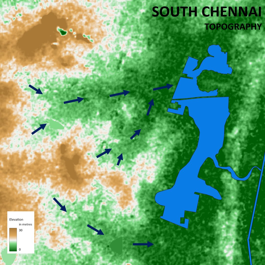
If we look at the topography map, the flow paths become clearer as in the map below. When water falls in these places, they are supposed to drain along these streams which appear only during monsoons Image
Let us zoom in further, these "conduits" are the ones that are supposed to carry water. I have added some water flow lines on top of the topography map here near Pallkaranai wetlands Image
Read 15 tweets
Oct 13, 2023
Thread:
A recent #satellite image of the sea near #Chennai's Marina beach. There are 3 dots in the image (red, green, blue). What causes it? Image
Satellites have cameras that observe reflection in different spectral bands (including red, green, blue). But they don't observe the same place at the same time and there is a very small lag between them. Meaning between red colour and green colour there is a time difference Image
Most of the objects (like buildings, lakes etc.) that satellites observe don't move that fast in microseconds and hence when image collages are created, it won't show any major difference. But what if objects like Aeroplane which move at say 800kmph is observed? Image
Read 6 tweets
Oct 8, 2023
#Thread: A Problem in the making. Two major problems faced by #Bengaluru are flooding and traiffic. But just like any other Indian city, unbridled urbanization is aggravating these crises and is making sure that these problems would stay for longer
1/n Image
In my previous posts, I have explained about the topography and valley system in #Bengaluru. These conveyor belts carry the flood waters of the city. It is across these valleys small dams were built primarily for irrigation purpose (which we now call as lakes)
2/n Image
The problem is that a lot of builtup area came across these valleys. Because of the way we construct, the materials we use, and them behaving as blocks, Bengaluru began having flooding problems as the valleys got blocked
3/n Image
Read 17 tweets
Oct 1, 2023
#Thread on Ponniyin Selvan #Maps
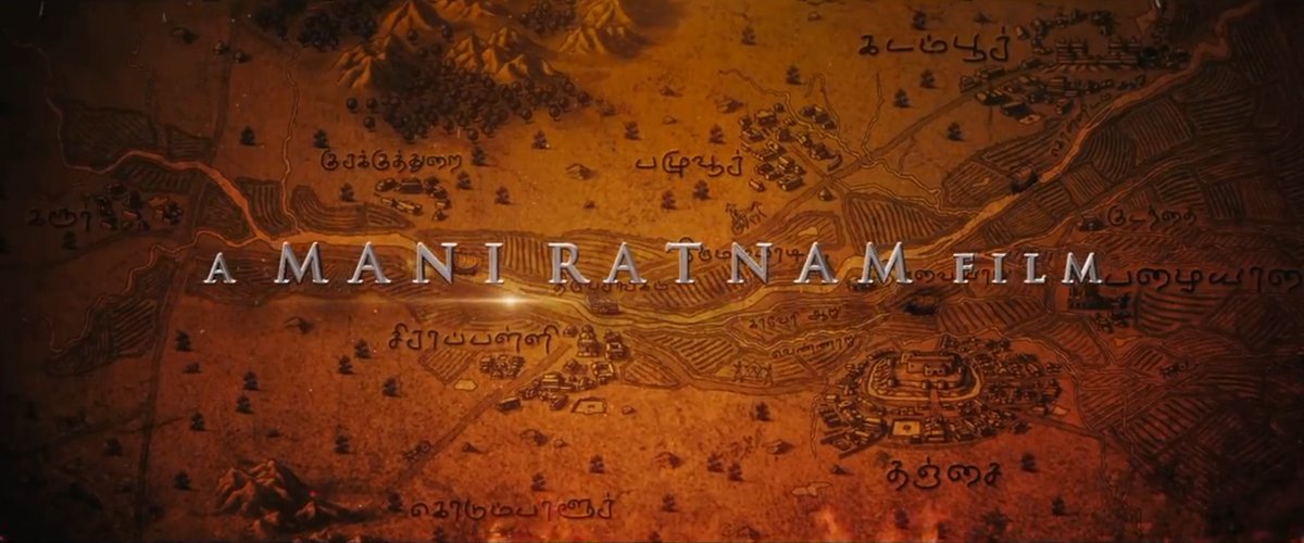
Last year, I had the opportunity to work as map consultant in director Maniratnam's magnum opus, #PonniyinSelvan movie. Though seen only in bg, there was a lot of professional effort put into maps which must be the 1st in Indian film industry 1/n Image
Maps show the core Chola territory and the areas that were conquered and subdued.

2/n
Image
Image
Before going into the details, we need to understand the core concepts behind the map. #Maps are visual representations of spatial realities. But while making balances have to be achieved between science, perceptions, history, creativity, & our ability to tell stories Image
Read 35 tweets

Did Thread Reader help you today?

Support us! We are indie developers!


This site is made by just two indie developers on a laptop doing marketing, support and development! Read more about the story.

Become a Premium Member ($3/month or $30/year) and get exclusive features!

Become Premium

Don't want to be a Premium member but still want to support us?

Make a small donation by buying us coffee ($5) or help with server cost ($10)

Donate via Paypal

Or Donate anonymously using crypto!

Ethereum

0xfe58350B80634f60Fa6Dc149a72b4DFbc17D341E copy

Bitcoin

3ATGMxNzCUFzxpMCHL5sWSt4DVtS8UqXpi copy

Thank you for your support!

Follow Us!

:(