
Earth Observer, Civil Engineer
Tweets: Data-Driven Decision Making, GIS, Remote Sensing, Water, Urban Development, Environment, Maps
 2. Linear arrangements in Assam
 Kerala is sandwiched between the Western Ghats and the sea. As a region with very heavy rainfall, the water has eroded the land and has created a lot of pathways. This created the ridge (upper land) and valley (pathways) system that we can clearly observe in the elevation map
 Equip yourselves with apps for more information from GPS.. Also notice the weaker signals from the satellites on the right side because I am sitting on the left side windows. Also preload maps in google maps so that you can identify features


 To provide context, this photo shows the area near the next to the temple which has eroded significantly and the beach used to extend further
 2. #Map shows the profile of four major rivers in India. Vijayawada is in the lower section of Krishna river and close to where the river exits the plateau and enters the deltaic flat plains.
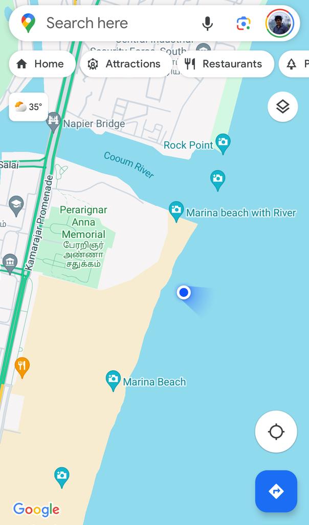
 In the previous thread, I had explained how Marina beach is growing (sea becoming more and more land). Because of the longshore drift, lots of sand hence gets settled in the mouths of Cooum River.
 This map below shows the approximate original coastline of Chennai during British era. It was much closer to the Kamarajar road. A promenade was developed during the british era and that is when it got the name, "Marina". However the big sandy expanse itself didnt exist
 1. This part of #Wayanad is within the Chaliyar river system. It is a west flowing river which drains into the laccadive sea on Kerala coast (though at this part it is north and east flowing)
 2. Contrary to popular opinion, the three seas (Arabic Sea, Bay of Bengal, Indian Ocean) don't meet in Kanniyakumari.
 Being in the top of a ridge line, the city is partly within Kaveri watershed and partly in Ponnaiyar (Dakshina Pinakini watershed).

 When my dad realized it, he searched in the train and rang me from his friend's phone at 3:51 AM to inform that his phone was stolen. Luckily, among immediate family members we have location sharing "on" which meant I could track the location of mobile. When I checked it, I realized that the mobile was moving along the track near Melapalayam in Tirunelveli so I deduced that the thief was returning back to Nagercoil in another train.
 1. The cyclone path had been more or less accurately predicted by IMD, private forecasters
 If we look at the topography map, the flow paths become clearer as in the map below. When water falls in these places, they are supposed to drain along these streams which appear only during monsoons
 Satellites have cameras that observe reflection in different spectral bands (including red, green, blue). But they don't observe the same place at the same time and there is a very small lag between them. Meaning between red colour and green colour there is a time difference
 In my previous posts, I have explained about the topography and valley system in #Bengaluru. These conveyor belts carry the flood waters of the city. It is across these valleys small dams were built primarily for irrigation purpose (which we now call as lakes)
 Maps show the core Chola territory and the areas that were conquered and subdued.

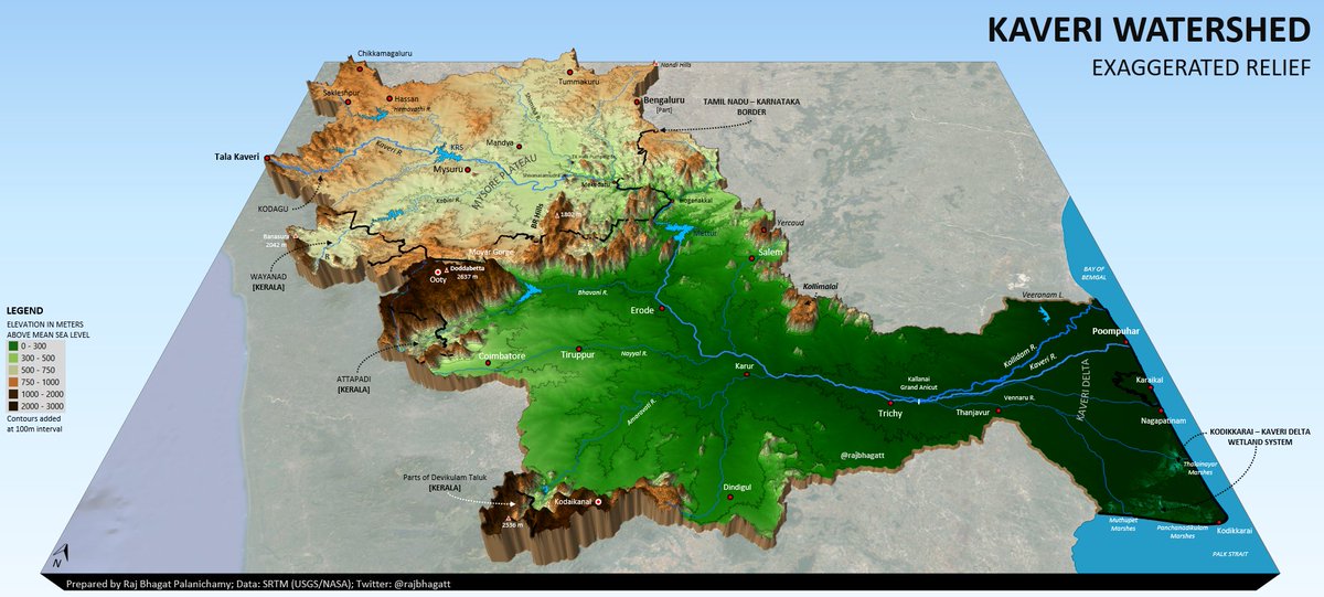 It raises from a myth that there are not enough dams/regulators in Kaveri.
 Like many streams and canals in urban environment in India, this stream also didnt have any buffer in case of severe floods and jailed with concrete walls and no room for it to breathe. For most of the year, these streams carry sewage water.
 Contrary to perceptions & opinions, Football is quite popular in many places in India like my town (Nagercoil, Tamil Nadu). 300-500 people (mostly young) attend matches even when conducted during the peak of summer and during a working day. Photo taken during pre-match
 What is wrong: