views

A significant Denver-area snowstorm is likely Wednesday-Friday, with the worst likely Wed. PM-Thursday.
However, there are still lots of questions around snow totals, and this remains one of the strangest Front Range big storm setups in recent memory.
Thread ->
#9wx #COwx
However, there are still lots of questions around snow totals, and this remains one of the strangest Front Range big storm setups in recent memory.
Thread ->
#9wx #COwx
A cutoff upper-level low will push south on Wednesday, spinning over southern Nevada. Meanwhile, a surface low sets up over SE Colorado late Wednesday, drawing up moisture.
The upper-level low won’t move much through early Friday, setting up a long rain-to-snow event.
#COwx
The upper-level low won’t move much through early Friday, setting up a long rain-to-snow event.
#COwx
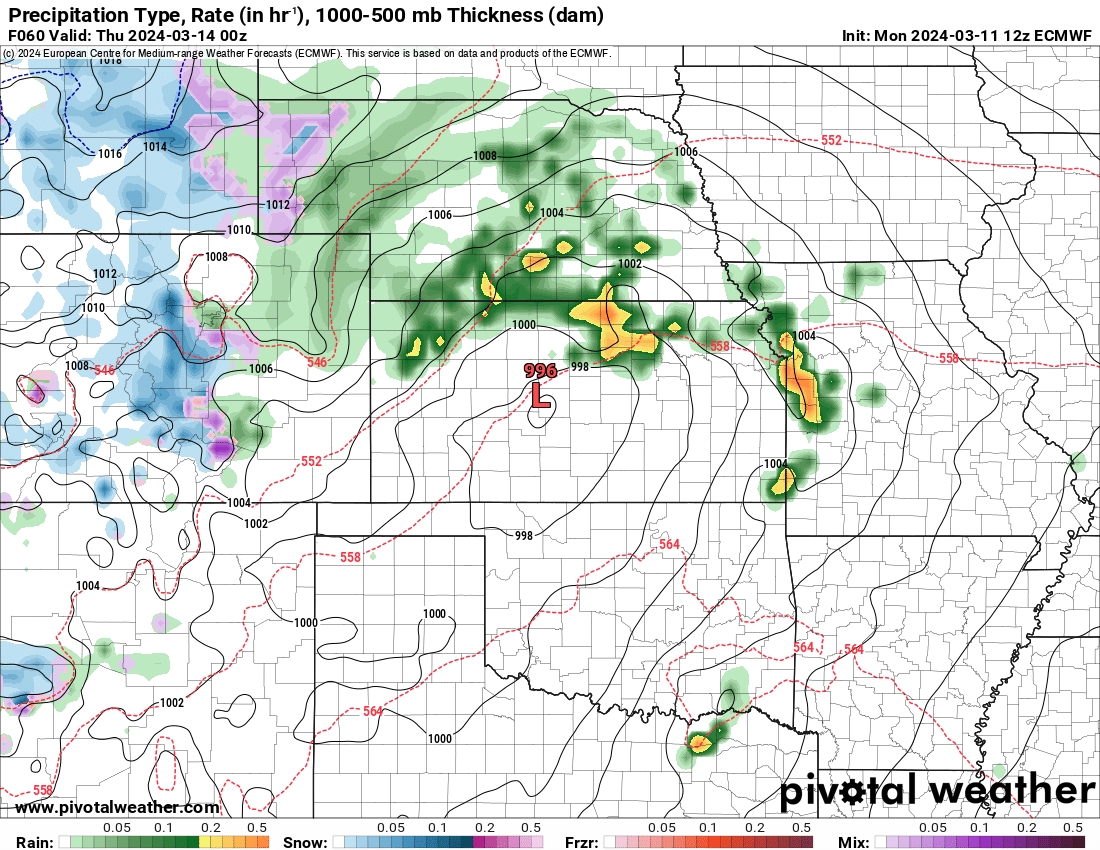
A significant 6”+ snowstorm remains likely for most of the Denver area Wednesday-Friday.
Highest totals likely above 6k feet west/south of Denver, where 20"+ snow is possible.
Honestly: I take back 10"+ for Denver. 6"+ is a good starting point (similar impacts, tho).
#COwx
Highest totals likely above 6k feet west/south of Denver, where 20"+ snow is possible.
Honestly: I take back 10"+ for Denver. 6"+ is a good starting point (similar impacts, tho).
#COwx
Timing: The storm likely starts as rain on Wednesday for lower elevations, including Denver. It’ll flip from rain to snow on Wednesday night or Thursday morning.
Heaviest snow: Wed. PM-Thurs AM (perhaps all day?). Snow likely doesn’t end until Friday morning.
#COwx
Heaviest snow: Wed. PM-Thurs AM (perhaps all day?). Snow likely doesn’t end until Friday morning.
#COwx
Why this could bust:
1) This is a very unusual setup for a big Denver snow, with upper level dynamics so far away.
2) How much rain falls? Will it coincide with the heaviest precip Wed. PM/Thu. AM?
3) Seasonal trend for storms to fizzle 24-36 hours before onset.
#COwx
1) This is a very unusual setup for a big Denver snow, with upper level dynamics so far away.
2) How much rain falls? Will it coincide with the heaviest precip Wed. PM/Thu. AM?
3) Seasonal trend for storms to fizzle 24-36 hours before onset.
#COwx
Storms falling apart! Yes, storms have seemingly fallen apart 24-36 hours before a storm several times this season.
But: We haven’t had this strong or clear of a signal this year.
Still worth considering, though that’s likely more coincidence than science.
#COwx
But: We haven’t had this strong or clear of a signal this year.
Still worth considering, though that’s likely more coincidence than science.
#COwx
Airport: Expect big impacts to @DENAirport this week.
If you’re flying Wednesday: earlier the better.
Thursday: Probably rough, with lots of cancellations likely.
Friday will likely have residual delays/issues.
#COwx
If you’re flying Wednesday: earlier the better.
Thursday: Probably rough, with lots of cancellations likely.
Friday will likely have residual delays/issues.
#COwx
Schools: Cancellations possible (likely?) Thursday and Friday, especially in the foothills. I’d guess most of the Denver area sees cancellations too, esp if we’re 10-12”+.
Reminder: I’m a meteorologist, not a school superintendent. Just a guess!
#COwx
Reminder: I’m a meteorologist, not a school superintendent. Just a guess!
#COwx
Power outages: With 1-2 feet of heavy, wet snow possible in the foothills, some power outages are possible there.
A higher-end storm could bring that into play in Denver, but not too worried about that yet for lower elevations.
#COwx
A higher-end storm could bring that into play in Denver, but not too worried about that yet for lower elevations.
#COwx
Takeaways:
1) Significant 6”+ snowstorm remains on track for the Denver area for Wednesday-Friday, with 1-2 feet likely in the foothills/south.
2) Still lots of uncertainty around temps/setup.
3) More tomorrow, including fancy maps + city-by-city probabilities.
#COwx
1) Significant 6”+ snowstorm remains on track for the Denver area for Wednesday-Friday, with 1-2 feet likely in the foothills/south.
2) Still lots of uncertainty around temps/setup.
3) More tomorrow, including fancy maps + city-by-city probabilities.
#COwx
• • •
Missing some Tweet in this thread? You can try to
force a refresh


