#Kharkiv : a new front opened by Russia 🇷🇺
The Northern Corps created a few days ago with +/- a 50k army has launched attacks aiming to take Voltchansk and Lyptsi.
Lets look together videos, maps, claims and hypothesis on this new Russian offensive.
🧵THREAD🧵🇺🇦1/18 ⬇️
The Northern Corps created a few days ago with +/- a 50k army has launched attacks aiming to take Voltchansk and Lyptsi.
Lets look together videos, maps, claims and hypothesis on this new Russian offensive.
🧵THREAD🧵🇺🇦1/18 ⬇️

First, where is this front located ?
Kharkiv is the seconth city of Ukraine, located ~35km from Russia. The frontline lies around the Siversky Donets river. This area was liberated by Ukraine on september 2022.
Kharkiv is the seconth city of Ukraine, located ~35km from Russia. The frontline lies around the Siversky Donets river. This area was liberated by Ukraine on september 2022.

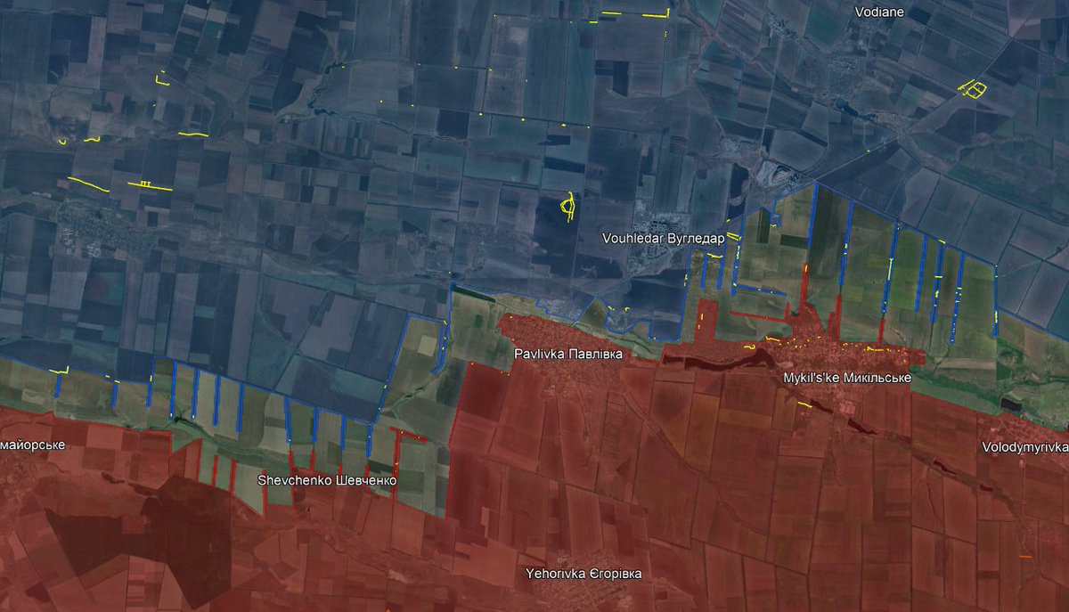
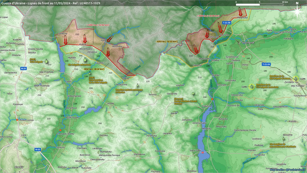
On this map by @Pouletvolant3 we can see that Russia has taken some villages in the grey zone. These may have been abandoned by Ukrainian territorial defense forces.
The first videos reaching us are somewhat reminiscent of the first months of the war of movement in 2022, but in a more cautious way. The infantry advances largely on foot, sometimes supported by BMPs which are targeted by Ukrainian suicide drones.
Thus, we have already some Russian losses on both sides of the border with Ukraine. Interestingly, it seems Ukrainian armed forces retreated from the border towns to prepared position a few kilometers away.

On the following videos, you will see Russian BMP's and infantry being targeted by drones. On the second one, there is a Ukrainian trench network abandonned by Ukraine.
Based on information shared by @Deepstate_UA and @UAControlMap, we can assure the following billages are under Russian controll : Strilecha, Krasne, Pyl'na, Morokhovets' and Oliinykove.
Borysivka is probably under Russian controll, no information.
Borysivka is probably under Russian controll, no information.

It seems Russian forces are now attacking Hlyboke and Luk'yantsi where Ukrainian forces may have retreated.
42nd mecanized brigade is defending this direction, main Ukrainian defensive line is located east and west of Lyptsi.
42nd mecanized brigade is defending this direction, main Ukrainian defensive line is located east and west of Lyptsi.

On the Volchansk direction, the Russian army penetrated from several directions into the forest towards the small city.
The villages of Ohirtseve and Hatyshche are under their control, that of Pletenivka probably also.
The villages of Ohirtseve and Hatyshche are under their control, that of Pletenivka probably also.

Interesting to observe how the Russian infantry marches without being disturbed by Ukrainian artillery and drones.
For the moment, the Russian advance which began 3 days ago is not a breakthrough. Maximum penetration is 5km.
For the moment, the Russian advance which began 3 days ago is not a breakthrough. Maximum penetration is 5km.
Why ?
The border between Ukraine and Russia is very long. They could've attacked on Chostka, Sumy or Okhtyrka direction but they choose Kharkiv.
3 main ideas : putting pressure on the city, extending the front, threatening Kupiansk.
The border between Ukraine and Russia is very long. They could've attacked on Chostka, Sumy or Okhtyrka direction but they choose Kharkiv.
3 main ideas : putting pressure on the city, extending the front, threatening Kupiansk.

Hypothesis 1 :
False attack north of Kharkiv, real attack betwee, Kupiansk and Tchouhouiv : enlarge the front and take kupiansk from the north, then secure all Siverski Donets banks.
False attack north of Kharkiv, real attack betwee, Kupiansk and Tchouhouiv : enlarge the front and take kupiansk from the north, then secure all Siverski Donets banks.

Hypothesis 2 :
Secure ~10km buffer zone and dig positions : then wait to keep Ukrainian units busy here. Putting Kharkiv back under GRAD fire.
This is what we have for now.
Secure ~10km buffer zone and dig positions : then wait to keep Ukrainian units busy here. Putting Kharkiv back under GRAD fire.
This is what we have for now.

Hypothesis 3 : do both
Secure northern Kharkiv oblast to force Ukrainian forces to deploy brigades there : threatening Kharkiv, Chuhuiv and Kupiansk.
Secure northern Kharkiv oblast to force Ukrainian forces to deploy brigades there : threatening Kharkiv, Chuhuiv and Kupiansk.

What i think ?
There is one main defensive line for Ukraine. With a 50k force, Russia can't take Kharkiv, however, they will divert Ukrainian forces from Donetsk oblast and will be bombing Kharkiv.
There is one main defensive line for Ukraine. With a 50k force, Russia can't take Kharkiv, however, they will divert Ukrainian forces from Donetsk oblast and will be bombing Kharkiv.

So Kharkiv offensive is a double trap :
If Ukraine divert too much forces from Donbass, Russian summer offensive will breakthrough.
If Ukraine does not defend Kharkiv direction, Russian army will advance and capture large portion of terrain, even threatening Kupiansk.
If Ukraine divert too much forces from Donbass, Russian summer offensive will breakthrough.
If Ukraine does not defend Kharkiv direction, Russian army will advance and capture large portion of terrain, even threatening Kupiansk.
So now, i will follow daily the situation on my account and on @atummundi's one (think tank account you should follow)
The situation is bad for Ukraine they will need more troops to defend this new front.
The situation is bad for Ukraine they will need more troops to defend this new front.

Finally, as always do not believe all these maps on Twitter : that's only speculation and false information.
There are some reliable mappers doing incredible work: for example, no one, even deepstate said they entered Vovtchansk.
18/18
There are some reliable mappers doing incredible work: for example, no one, even deepstate said they entered Vovtchansk.
18/18

And of course i can add this firm image : a lot of Russian bombing. 3 Bridges on Siversky Donets river destroyed including the big one in Stary Saltiv.


Confirmation of Russian presence in Hatyshche north of Vovtchansk.
Well now they may have entered the city according to Ukrainian officials.
https://twitter.com/Militarylandnet/status/1789634346439110877
• • •
Missing some Tweet in this thread? You can try to
force a refresh