Nathan Ruser Profile picture
May 20 3 tweets 2 min read Read on X
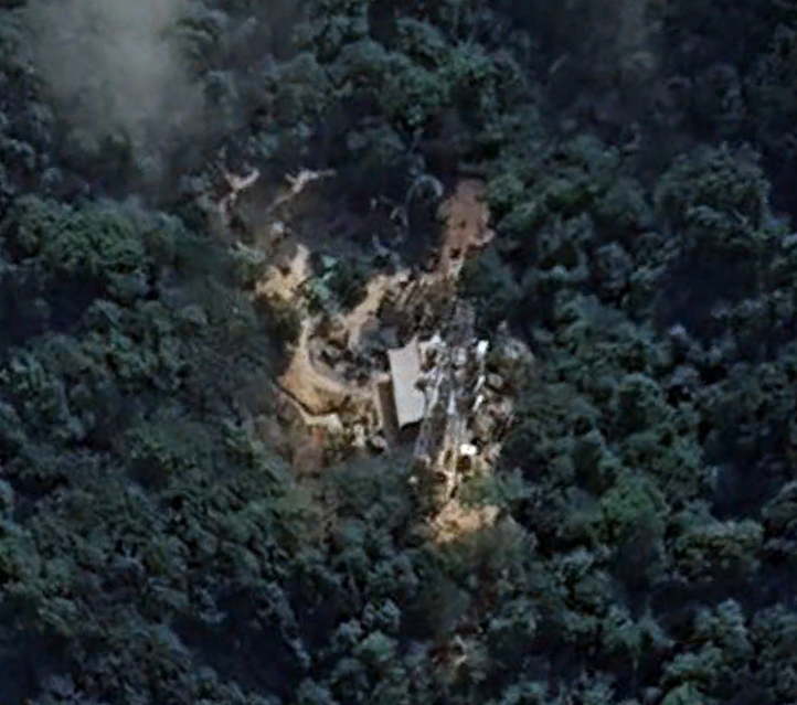
Geolocation of the wreckage in initial photos from the helicopter crash that likely killed Iranian president, Ebrahim Raisi.
38.718959, 46.654892
google.com/maps/place/38%…

Image
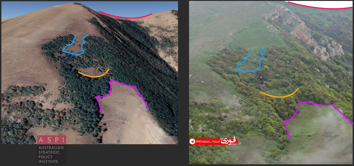
A quick BTS post on tips for geolocating this. In climate and biomes like this the thicker tree-growth is always (in the N hemisphere) on the northern slope of the hills, which made it immediately clear the camera was facing W, and since it was a helicopter crash into the side of a mountain, it was likely quite high (vs the Turkish drone coordinates that were 100m off the valley bottom). So geolocating was just a matter of getting roughly the right height and angle, facing west and scrolling across Google Earth until you find the approximate vegetation signature and a very smooth saddle on the ridgeline.
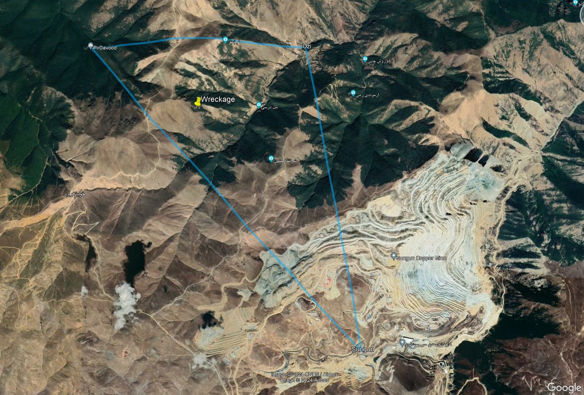
The initially reported search area was apparently around a 10km2 triangle between Uzi, Sungun and a forest shrine, with the wreckage being found ~12 hours later in the very middle of that area. To take that long to find it suggests that Iran's SAR capabilities are sorely lacking, a consumer thermal drone probably could have found it in the fog over that time~Image

• • •

Missing some Tweet in this thread? You can try to force a refresh
 

Keep Current with Nathan Ruser

Nathan Ruser Profile picture

Stay in touch and get notified when new unrolls are available from this author!

Read all threads

This Thread may be Removed Anytime!

PDF

Twitter may remove this content at anytime! Save it as PDF for later use!

Try unrolling a thread yourself!

how to unroll video
  1. Follow @ThreadReaderApp to mention us!

  2. From a Twitter thread mention us with a keyword "unroll"
@threadreaderapp unroll

Practice here first or read more on our help page!

More from @Nrg8000

May 11
🧵A very brief OSINT methods thread to share how I found the location of a Burmese junta camp that was captured by the resistance today, it's a method I've used a lot for more obscure unnamed places that would be nearly impossible to find otherwise.
Image
Image
Today news came out from a reputable local media source of a junta camp that was captured in Southern Myanmar, normally news in Burma is reported with the name of a nearby village or at least the township. But not here, only that it was in the KNLA's 4th Brigade 11th Battalion. Image
The KNLA's 4th Brigade operates in Tanintharyi Region, and google searching for info about the 11th battalion shows it is mainly active in Bokpyin township

But of course, finding one tower with a loose lead of maybe a township is going to be tricky.bnionline.net/en/news/killin…
Read 14 tweets
Feb 25
I've started reading Our Enemies Will Vanish, a masterful book on the Ukraine War by @yarotrof. Highly recommend it. It contains heaps of tidbits and insights that even someone who followed the invasion closely (i'll count myself) had no idea of.
I'll share some threaded here. Image
@yarotrof (get your hands on the book if you possible can, the tidbits here are just the tip of the iceberg, truly recommend reading the whole thing).
Firstly, this account of a meeting between Bill Burns and Putin months before the invasion where Putin cited US' impotence post Afghanistan Image
@yarotrof And that Ukraine's military preparations on the heel of US intel warnings were so secret that even Washington had no idea about them (to prevent info going from GUR > DC > Kyiv > Russian Fifth Column) Image
Read 7 tweets
Nov 23, 2023
I was wanting to check if this IDF graphic was an approximation or a measured/to-scale diagram, so by tracing the various video walkthroughs, I was able to make my own NOT TO SCALE map, suggesting it was a pretty accurate representation but missing some 'branches' explored since.
Image
Image
The most notable difference is a partially-blocked tunnel leading beyond where the walkthroughts turn left to go towards the spiral staircase. A seperate IDF video showed a 3rd entrance around 125m beyond that intersection, so I've assumed that's where it leads. Image
I've done my best geolocating that entrance by looking for a wide-ish street (with no road markings), that curves slightly to the right & goes downhill, and that has two visible small but distinct orange-roofed areas, along with some vegetation in a front yard. Decent match.
Image
Image
Read 6 tweets
Nov 17, 2023
In Loikaw, a State capital in Myanmar, the district court has been overrun and destroyed by the KNDF and its armed resistance. After capturing the university on Wednesday, they are now barely 1km from the state capital building.
Image
Image
The attack on Loikaw comes simultaneously as an attack on Moebye, another major town nearby where ~6 Junta posts have been captured. The KNDF has been spending the last week systematically eradicating junta presence from between Moebye and Loikaw, to stage for these attacks.
Image
Image
The KNDF has now captured the Kayan Tharyar Crossroads junta outpost on the highway linking Loikaw & Shan State. The only outpost in the Loikaw surrounds still under junta control is the Kone Thar outpost which appears to have not been attacked since it's on an evacuation route.

Image
Image
Image
Read 4 tweets
Oct 20, 2023
😮‍💨
Looking at the 'splash' analysis is only relevant if the projectile had completed a nice parabolic trajectory & fired correctly.

It has next to no relevance in a hypothesis where there's a misfire and a mostly 'falling' projectile. Therefore, this isn't really helpful.
I have the utmost respect for Forensic Architecture, but when the analysis conducted is only valid in the scenario of one hypothesis and is invalid had the circumstances of another hypothesis happened, then it's not really useful in determining between them.
One quick look at the video of the missile that practically everyone has seen (and I'm sure FA has too) shows that this projectile wasn't on a clean parabolic trajectory and appears to be changing direction mid-air.
Read 15 tweets
Oct 19, 2023
This 'investigation' is flawed. It concludes that the al-Ahli hospital explosion was from an Iron-Dome intercepted rocket that fell/exploded.

This is demonstrably untrue as the Iron-Dome is a terminal-phase interceptor. It does not intercept in the launch phase.
Image
This is why it can be known as the 'Iron-Dome shield', each missile battery can defend against ~150km2 and targets the rockets towards the end of their trajectory, after the fuel has burnt off and the trajectory is more predictable.
Image
Image
You can see this in this video, where the rockets are struck after reaching the peak of their trajectory and at the beginning of the descent-phase
Read 7 tweets

Did Thread Reader help you today?

Support us! We are indie developers!


This site is made by just two indie developers on a laptop doing marketing, support and development! Read more about the story.

Become a Premium Member ($3/month or $30/year) and get exclusive features!

Become Premium

Don't want to be a Premium member but still want to support us?

Make a small donation by buying us coffee ($5) or help with server cost ($10)

Donate via Paypal

Or Donate anonymously using crypto!

Ethereum

0xfe58350B80634f60Fa6Dc149a72b4DFbc17D341E copy

Bitcoin

3ATGMxNzCUFzxpMCHL5sWSt4DVtS8UqXpi copy

Thank you for your support!

Follow Us!

:(