🧵THREAD🧵
La guérilla de la route de Kiev 🇺🇦
De février à début avril 2022, l’armée Ukrainienne a mené une guérilla défensive sur un front de 400km pour protéger Kiev.
Cartes, vidéos et analyse de cette guérilla cruciale⬇️
La guérilla de la route de Kiev 🇺🇦
De février à début avril 2022, l’armée Ukrainienne a mené une guérilla défensive sur un front de 400km pour protéger Kiev.
Cartes, vidéos et analyse de cette guérilla cruciale⬇️

Dispositif Russe pour attaquer Kiev :
- 35ème armée (Nord et Ouest)
- 36ème armée Tchernihiv (Nord-Est) (E95-P13)
- 41ème armée Nord-Est) (P12)
- 6ème/2èmearmée (Est) (M02)
- 1ère armée de chars de la garde (Sud-Est) (P61-H07)
- 35ème armée (Nord et Ouest)
- 36ème armée Tchernihiv (Nord-Est) (E95-P13)
- 41ème armée Nord-Est) (P12)
- 6ème/2èmearmée (Est) (M02)
- 1ère armée de chars de la garde (Sud-Est) (P61-H07)

Dispositif défensif Ukrainien :
- 1ère brigade de chars (Tchernihiv-Nyzhin-Brovary)
- 72ème mécanisée (Brovary)
- 58ème Motorisée (Pryluky-Romny)
- 93ème Mécanisée (Othyrka-Hadiatch)
- Civils-défense territoriale (Soumy, Tchernihiv, Hlukhiv, Konotop…)
- 1ère brigade de chars (Tchernihiv-Nyzhin-Brovary)
- 72ème mécanisée (Brovary)
- 58ème Motorisée (Pryluky-Romny)
- 93ème Mécanisée (Othyrka-Hadiatch)
- Civils-défense territoriale (Soumy, Tchernihiv, Hlukhiv, Konotop…)

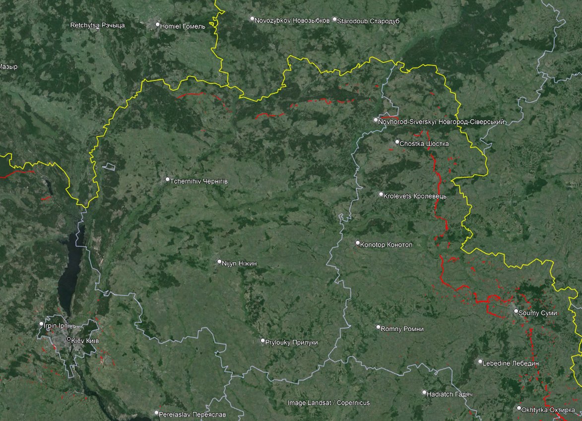
L’attaque de la route E95 a pour but de s’emparer de Tchernihiv et de ses 4 ponts sur la Desna. L’objectif est de contourner la ville.
Le 24 fev 2022, l’armée UKR évacue la ligne Ripky-Horodnia et fait sauter les ponts sur le Dniepr et la Desna avant de se retirer à Tchernihiv.
Le 24 fev 2022, l’armée UKR évacue la ligne Ripky-Horodnia et fait sauter les ponts sur le Dniepr et la Desna avant de se retirer à Tchernihiv.
A Tchernihiv, l’armée Russe subit une lourde défaite qui piège la 36ème armée restant bloquée autour de la ville un mois et demi.
Le contournement par l’ouest et la prise de Yahidne (où des massacres sont commis) permet d’attaquer Brovary en sous effectifs.
Le contournement par l’ouest et la prise de Yahidne (où des massacres sont commis) permet d’attaquer Brovary en sous effectifs.
Sur la P13 et la P56, les tentatives d’encerclement de Tchernihiv fonctionne, mais la 1ère brigade de char, la garde nationale et la défense territoriale communique toujours avec le bastion de Nizhyn. Sans Tchernihiv, la Russie ne pouvait pas prendre Kiev. (carte @JominiW)

Le chemin de la 41ème armée est bien plus long et fait face à la quasi absence de la défense Ukrainienne qui se réfugie à Nizhyn.
Cette 41ème armée Russe est relativement inutile, elle apporte de l’aide à l’ouest de Tchernihiv et galère à passer la Desna.
Cette 41ème armée Russe est relativement inutile, elle apporte de l’aide à l’ouest de Tchernihiv et galère à passer la Desna.


Cette armée devait probablement avancer vers Mena puis Nizhyn. Les deux villes n’ont pas été prise, Mena, défendue principalement par des civils et Nizhyn par la 1ère brigade de chars.
C’est vers les 2èmeet 6ème armée que les regards se portent maintenant.
C’est vers les 2èmeet 6ème armée que les regards se portent maintenant.

L’armée Ukrainienne, principalement des éléments de la 58ème brigade motorisée évacue à la hâte Hloukhiv, Krolevets, Konotop et Buryn.
Dans les deux première, police et volontaires vont tenir l’encerclement. Plusieurs véhicules sont perdus durant le retrait.
Frontière et Buryn📹
Dans les deux première, police et volontaires vont tenir l’encerclement. Plusieurs véhicules sont perdus durant le retrait.
Frontière et Buryn📹


Après des avancées rapides malgré la résistance locale et les blocages des civils, les éléments de ces deux armées arrivent en vue de la ligne Nizhyn-Prylouky ou ils font face à une vive résistance.
Repoussés sur les routes de campagnes, ils subissent des pertes.
Repoussés sur les routes de campagnes, ils subissent des pertes.


La situation se débloque le 3 mars lorsqu’ils profitent du trou entre la 1ère brigade de chars à Nizhyn et la 58ème motorisée à Prylouky pour enfoncer les lignes et avancer jusqu’à Brovary.
La 1ère brigade de char, encerclée se replie entre Nizhyn et Tchernihiv.
La 1ère brigade de char, encerclée se replie entre Nizhyn et Tchernihiv.

L’attaque Russe butte cependant avec surprise sur le gros des forces Ukrainienne, la 72ème brigade mécanisée et les forces spéciales Ukrainiennes établissent une ligne dure à 30km de Kiev.
Les colonnes Russes sont décimées.
Les colonnes Russes sont décimées.


La 1ère armée de char de la garde qui échoue à prendre Soumy contourne la ville, pourtant défendue par des civils et fait route via Romny et Prylouky (qu’elle prend soin de contourner) pour débouler sur l’est de Kiev en renfort.
C’est une ligne logistique de 300km à tenir avec une pression constante des 58ème motorisée et 93ème Mécanisée au sud, 1ère brigade de char au nord, forces spéciales et défenses territoriales au milieu, que ce soit dans les villes encerclées et dans la campagne.

L’armée Russe perd ainsi du temps à réduire les défenses Ukrainiennes, des hommes qui doivent tenir les encerclements et les lignes d’approvisionnement et beaucoup de blindés dans des embuscades tout le long de la route.


Lorsqu’elle arrive aux portes de Kiev, que ce soit à Brovary, Noba Basan ou Rusaniv, l’armée Russe est affaiblie et explosée par les unités d’expériences Ukrainiennes.
Son aviation fait de rares apparitions mais reste dépassée malgré quelques frappes. + Bayraktar Ukrainien.
Son aviation fait de rares apparitions mais reste dépassée malgré quelques frappes. + Bayraktar Ukrainien.
Pour les villes encerclées, une seule est défendue par une brigade : le couple Tchernihiv-Nizhyn est bien gardé par la 1ère brigade de chars, tandis que Konotop, Hloukhiv, Mena, Chotska ou même Soumy sont défendues par la police locale et les civils.
L’histoire de Soumy est bien particulière.
Abandonnée par l’armée Ukrainienne, le commandement général se rend compte plusieurs jours après que la ville est toujours sous le contrôle des civils. L’armée Russe croyait faire face à l’armée Ukrainienne mais c'était des volontaires
Abandonnée par l’armée Ukrainienne, le commandement général se rend compte plusieurs jours après que la ville est toujours sous le contrôle des civils. L’armée Russe croyait faire face à l’armée Ukrainienne mais c'était des volontaires


Plus au sud, Okhtyrka est bien défendue par la 93èmeBrigade mécanisée dès le premier jour malgré les frappes aériennes. Si c’est l’axe de Poltava qui est d'abord défendu, c’est aussi celui de Kiev. L’armée Russe contourne la ville et prend Trostianets.

La 1ère armée de chars Russe ira jusqu’à Hadiatch dans l’oblast de Poltava avant de perde bataille sur bataille jusqu’à la libération de Trostianets fin mars qui lève l’encerclement de Soumy.


La défaite à Tchernihiv, Soumy et Brovary est de plus en plus coûteuse, repoussée villages après villages, l’armée Russe décide finalement un retrait généralisé du Nord-Est du pays abandonnant bon nombre de matériel.
La victoire ukrainienne repose d’abord sur cette guérilla. Retraite organisée jusqu’aux centres urbains et harcèlement sur les routes et en campagne sont les fruits de la victoire. On notera aussi le rôle prépondérant des civils.
Cette victoire ukrainienne laisse cependant des traces: l’absence de défenses à la frontière (comblé en 2024), mines, meurtres, viols, destruction… Les “héros” des routes de Kiev sont probablement morts aujourd’hui…
Chacune des ces batailles vaudrait un thread, avec mes recherches, je pourrais écrire des threads entiers sur les batailles précises: Tchernihiv, Nizhyn, Nova Basan, Soumy, Trostianets, Okhtyrka, Romny, Brovary…

Nous allons donc faire un sondage, la prochaine fois nous évoqueront un épisode en particulier, choisissez lequel :
Abonnez vous à @atummundi
(Cartes @JominiW et @Deepstate_UA , merci à eux !)
25/25 Merci !
Abonnez vous à @atummundi
(Cartes @JominiW et @Deepstate_UA , merci à eux !)
25/25 Merci !
• • •
Missing some Tweet in this thread? You can try to
force a refresh