Carte générale du front nord le 10 mars 2022. L'armée Russe contrôle les routes principales, évite les villes sous contrôle sois de l'armée ukrainienne, soit des civils de la défense territoriale + forces locales (police). 2/9
Au nord est, peu ou pas de résistance Ukrainienne. Konotop, Mena et Hloukhiv sont sous le contrôle des civils qui refusent l'entrée de l'armée Russe qui prend soin de contourner ces villes.
Incertitude pour Chotska et Krolovets. 3/9
Autour de Tchernihiv et Nizhin, la 1ère brigade de chars, en partie encerclée résiste avec la 117ème brigade de défense territoriale de Tchernihiv.
Les principaux combats se déroulent au sud de Tchernihiv, l'armée Russe tente d'encercler la ville. 4/9
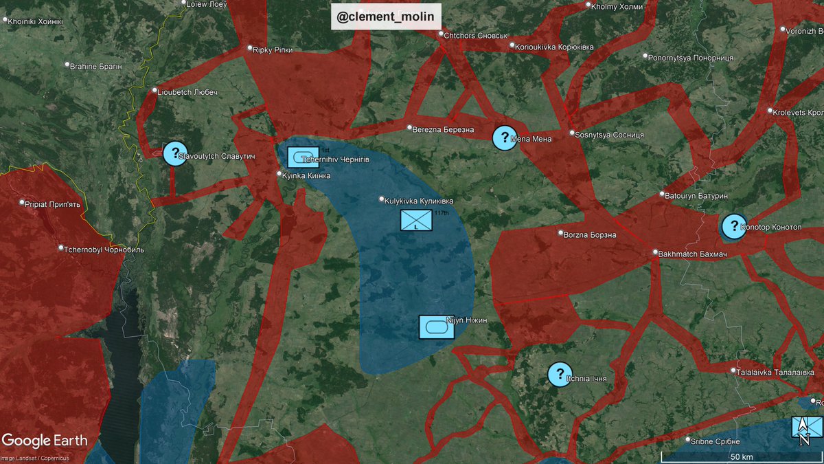
Entre Prylouky et Nizhyn, les unités de la 1ère armée de tanks de la garde ont percé les défenses à al jonction de la 58ème brigade motorisée et de la première brigade de chars autour du 3 mars 2022. 5/9
Devant Kiev, les unités Russes fatiguées par un voyage de 400km, des combats permanents contre les FS Ukrainiennes et la bataille de ralentissement va se confronter à la 72ème brigade mécanisée qui les attends. 6/9
Plus à l'est, à la frontière de l'oblast de Poltava, les unités Ukrainiennes mettent la pression sur les routes le long d'une ligne Prylouky-Romny-Hadiatch-Orkhtyrka.
La résistance se poursuit à Leybedine et Soumy. 7/9
Tout cela évidemment dans la perspective de la première véritable contre offensive de la guerre lorsque la 93ème brigade mécanisée repousse les Russes de Trostianets et libère Soumy de l'encerclement dans le prochain thread. 8/9
Je vais améliorer cette carte pour avoir une idée précise de l'ordre de bataille autour du 10-15 mars, lors de l'avancée maximale de l'armée Russe.
Merci à ceux qui me suivent depuis peu et ceux qui me suivent depuis le début ! 9/9
• • •
Missing some Tweet in this thread? You can try to
force a refresh
Big victory for the Sudanese 🇸🇩 Army after they lifted the 2.5 years long siege of the city of Dilling
It is the biggest victory for the SAF since they liberated the capital city a year ago. At the same time, RSF attempted to open a new front in Blue Nile.
Massive forces led by the 5th division of El Obeid, the 10th division of Abu Jubaynah as well as the brigades 53rd and 38th and joint forces entered today the city of Dilling in South Kordofan.
After a month long counter-offensive south of El Obeid, those forces took the Rapid Support Forces by surprise, pushed on open terrain between the Nuba mountains and reached Habila this morning.
After that, they continued their push and reached the city of Dilling, one of the two remaining encircled garrison (after most fell, apart from Kadugli, capital city of south Kordofan, still encircled.
Held by the 54th infantry brigade alone, the city stood 2.5 years.
Who are the actors, why are they fighting ? Is the conflict origine from money, gold, oil, power, religion or ethnicities ? Which foreign powers are involved ?
Here, you will find a general guide of the Sudan war :
🧵THREAD🧵1/24 ⬇️
When did it start ?
On april 15th 2023. Where ? In Khartoum, the capital city, unlike previous conflicts.
Sudan was already partly at war before, discontinuously since 1983 (1983-2005, 2nd South Sudan war, 2003-2020, Darfur war, 2011-2020, South Kordofan and Blue Nile war).
Who is fighting :
The Sudanese Armed Forces :
The SAF are based in Khartoum and Port Sudan; they defend the state's borders and internal stability. Their leader is Al-Burhan, and the military commanders are heirs to the military-Islamist regime of Omar al-Bashir (1989-2019).
A partir de la situation actuelle et sans entrer dans l'éventualité de négociations/cessez le feu, voyons 6 scénarios de la poursuite de l'offensive russe, par rapport aux objectifs stratégiques de Moscou 🇷🇺.
🧵THREAD🧵1/12 ⬇️
D'abord, je vous invite à relire le point de l'année dernière sur le même sujet, qui s'est avéré proche de la réalité
Ce ne sont que des hypothèses à partir de la situation actuelle, je ne dis pas que ça va se passer comme ça.
The war in Ukraine 🇺🇦 has changed so much that the differencies on the maps are sometimes measured in 5, 10, or even 15km !
A number of pro-Russian 🇷🇺 accounts use a flag, a lone dead soldier as proof of control (or perhaps it's pro-Russian propaganda or even their own imagination).
The result? Completely absurd maps that does not show the reality on the ground, and when an error is admitted, a Ukrainian counter-offensive that came out of nowhere is presented.
1/8 ⬇️
Thanks to this map, ukraineviews.org, we can see the difference between the areas of control according to the main mappers of the war in Ukraine. The maps are roughly half pro-Russian and half pro-Ukrainian.
Let's take the example of a specific area of the front, southeast of Pokrovsk:
According to pro-Russian mappers, the Russian army controls the villages of Bratske, Vidradne, Hai and Oleksivka.
According to most pro-Ukrainian mappers (some are neutral), these villages are either in the gray zone or controlled by the Ukrainians.
What are the proofs to suggest something ?
For Bratske : A single video (!) dated January 8th, showing two Russian soldiers with a flag. Is this irrefutable proof of a Russian presence? Does it mean the Russians control the village (i.e., they have forces there and are using it as a base for launching offensives)?
As Playfra explained here: x.com/Playfra0/statu…, barbed wire has been placed in multiple villages along the front line in this sector. This directly contradicts the control lines of some mappers.
For Vidradne, not a single video confirms the Russian claims. For Hai, there is a video of soldiers with the flag from two months ago. Since then, the barbed wire in front of the village has been reinforced, yet several maps show the village as Russian. In Oleksivka, we have plenty of videos of Russians from before 2026. Since then, nothing. Where is the evidence of effective control?
After losing the Battle of Mykolaiv, Russian forces retreated behind new defensive lines along the border of Kherson Oblast.
Russian forces arriving from the Kyiv Front took considerably longer than the first Ukrainian brigades sent as reinforcements. These brigades brought reinforcements that pushed the Russians back behind the Inhulets River and established defensive lines in front of Mykolaiv.
Ukrainian 🇺🇦 forces continue to prepare important obstacle lines everywhere on the frontlines.
In the Donbas, we now have multiple "New Donbas Lines", as well as tens barbed wire lines, In Zaporizhzhia, there is now more and more of those barbed wire. Every progress will be costly.
▪️East and South of Kramatorsk, we can count numerous small obstacle lines. West of the city, we can count 3 large lines (the third one is being expanded north), each cut every 10km by a parallel line (I can count around 4 right now), forming small 10/5km rectangles.
▪️In the south, the Novomykolaivka line is now continuous, it is 100km long. East of it, it seems too late to build new lines, but ukrainian forces started to prepare multiple barbed wire lines west of their current defense, the Haichur river.
▪️North of the two defensive lines built in 2024 (the big lines looking south), we can see the first preparations for a third reinforced line that will probably join the Novomykolaivka and the Vilniansk ones, offering a retreat line north of Orikhiv.
▪️In the Pavlohrad direction, a third line in front of Vassylivka is being prepared. The first one is the unfinished line in front of Pokrovsk'e which continues in front of Prossiana, the second is the nearly finished one, which is the longest continuous line Ukraine has (it goes from Ternuvate to Kramatorsk, that's the big one going behind the main cities) and this third line is being prepared south of Vassylivka and west of the second.
▪️Despite the snow, a lot of construction is ongoing everywhere in Ukraine and new lines are getting ready. Every week Russia is waiting means more time and men to get through those lines.
Here those "kill rectangles", the new portion we've been waiting for to connect Veliky Burluk line with Karkhiv one, the multiple barbed wire in front of Prossiana and a map of all Ukraine.
Here a simplified view, with in yellow the main lines and in white secondary lines.