Russian 🇷🇺 invasion map 10 march 22, when they controlled the biggest proportion of Ukraine 🇺🇦 (23%)
Unlike some say, their main axis was Kyiv and if they stepped back, it's because they lost at Irpin, Tchernihiv, Nova Busan and Sumy. There was no "diversion".
🧵THREAD🧵1/12 ⬇️
Unlike some say, their main axis was Kyiv and if they stepped back, it's because they lost at Irpin, Tchernihiv, Nova Busan and Sumy. There was no "diversion".
🧵THREAD🧵1/12 ⬇️

When they attacked on february 24th 2022, unlike their "diversion" propaganda, their main force was positionned north of the country.
5th, 35th, 36th, 41st, 6th and 2nd CAA aimed at Kiev + 29th CAA to divert Ukrainian forces near Rivne-Lutsk.
5th, 35th, 36th, 41st, 6th and 2nd CAA aimed at Kiev + 29th CAA to divert Ukrainian forces near Rivne-Lutsk.

1st GTA army is aimed at Kiev and Poltava but can't take Sumy and Okhtyrka.
6th CAA (other part) is attacking Kharkiv while 20th CAA targets northern Donbass.
6th CAA (other part) is attacking Kharkiv while 20th CAA targets northern Donbass.

Apart from 8th CAA aimed at Marioupol, there are no new Russian units in Donbass.
LPR and DPR army corps won't attack until 150th Motor Rifle Division from 8th CAA break through Popasna in middle april.
LPR and DPR army corps won't attack until 150th Motor Rifle Division from 8th CAA break through Popasna in middle april.

Southern Ukraine is attacked mainly with 58th CAA and elements of 49th CAA. Some units of 49th CAA and 22nd AC waited to be landed near Odessa.

This was probaby the plan :
5th, 35th = take Kiev (west + south)
36th, 41st take Tchernihiv + Kiev (east)
2nd = take Sumy -> Kiev
1st = take Poltava -> Dnipro
6th = take Kharkiv -> Dnipro
20th/8th = encircle Donbass
58th = take Marioupol, Zaporijia + Odessa
5th, 35th = take Kiev (west + south)
36th, 41st take Tchernihiv + Kiev (east)
2nd = take Sumy -> Kiev
1st = take Poltava -> Dnipro
6th = take Kharkiv -> Dnipro
20th/8th = encircle Donbass
58th = take Marioupol, Zaporijia + Odessa

On the Ukrainian side, the majority of units are in the Donbass on rotation. Some are in Kiev, 1 st TB is encircled between Nizhyn and Tchernihiv.
58th, 93rd and 92nd defend Kharkiv-Sumy axis.
Many units in Odessa/Mukolaiv.
58th, 93rd and 92nd defend Kharkiv-Sumy axis.
Many units in Odessa/Mukolaiv.


Why did they lost in Kyiv ?
They broke through ukrainian line between Pryluky and Nizhyn. However, they failed to controll both big and small urban areas like Sumy, Konotop, Mena...
They were always attacked on the supply roads (400km).
They broke through ukrainian line between Pryluky and Nizhyn. However, they failed to controll both big and small urban areas like Sumy, Konotop, Mena...
They were always attacked on the supply roads (400km).

When they failed to enter Kyiv in Brovary, they tried many times in the countryside. However, at the end of march, 72nd mecanized brigade counterattacked and regained positions including Nova Busan, pushing back Russian army far from Kyiv.

It was the same on the other side of Kyiv, Ukrainian counterattacked near Makariv and Borodianka, pushed back the Russian from Irpine. It was unecessary to continue fighting there.

And finally, 93rd mecanized brigade lifted the siege of Sumy by taking back Trostianets. It was a clear Russian defeat and their supply lines north of Sumy were endengered.

So there were no goodwill gesture or Istanbul aggreement. Then they took Sievierodonetsk and Marioupol, they sustained a blow at Kharkiv and Kherson and began a new Donbass campain, Bakhmout, Avdiivka and now Toretsk and Tchasiv Yar.
12/12
12/12
And yeah, i launched myself in a series of historical threads around this war.
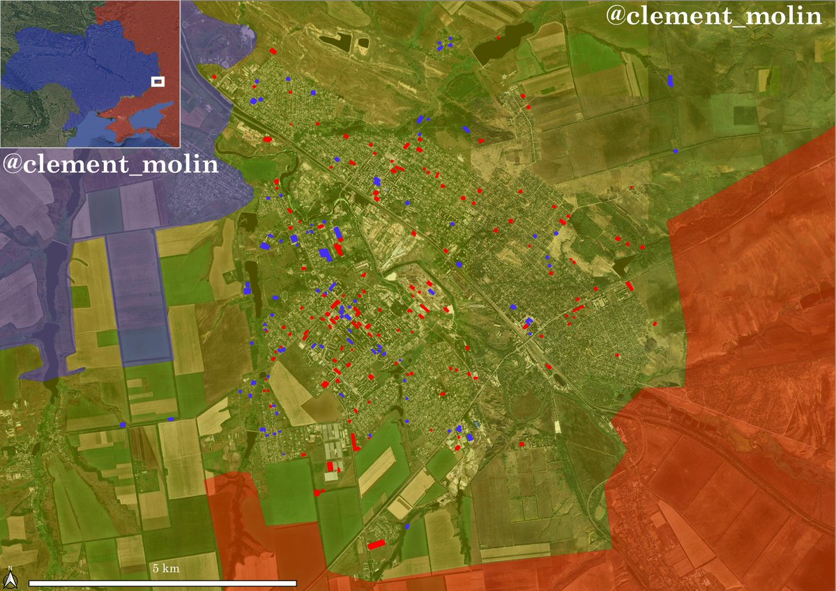
Here are Russian losses from lost warinua if you don't believe me.
Here are Russian losses from lost warinua if you don't believe me.

Tomorrow i'll show you how 1 500 men faced a 25 000 men army in Kherson.
I already made a 3 threads on that topic, despicting events, and now i'll show you the result with maps !
I already made a 3 threads on that topic, despicting events, and now i'll show you the result with maps !

• • •
Missing some Tweet in this thread? You can try to
force a refresh