While russian 🇷🇺 forces are nearing #Pokrovsk city in western Donetsk oblast, ukrainian 🇺🇦 forces managed to hold this advance.
At the same time, ukrainian forces are reinforcing their 3rd and 4th lines of defense.
🧵THREAD🧵1/16 ⬇️
At the same time, ukrainian forces are reinforcing their 3rd and 4th lines of defense.
🧵THREAD🧵1/16 ⬇️

Here is how ukrainian defensive system was organized after Avdiivka fell in late february.
The 1st and 2nd line fell between june and august. If the first one was very useful, the second line was mainly abandonned.
The 1st and 2nd line fell between june and august. If the first one was very useful, the second line was mainly abandonned.

This happened for one main reason, russian forces managed to push on foot along the railway. They first took Ocheretyne in late may, then Prohres in july, then Zhelanne at the end of july and Novohrodivka at the end of august.

After retreating during 2 months of summer, ukrainian brigades are now defending the 3rd line of defense stopping russian progress for more than a week.
At the same time, engeneering troops are upgrading the 4th line in front of Pokrovsk.
At the same time, engeneering troops are upgrading the 4th line in front of Pokrovsk.

Based on ©Planet Imageries from yesterday, I found a lot of new defensive work for the last 10 days.
Here is a look north of Novohrodivka where the main ukrainian vulnerability is present : the railway.
Here is a look north of Novohrodivka where the main ukrainian vulnerability is present : the railway.

Russian artillery and FABs air strikes are beginign to pound Pokrovsk and its neighbouring city Myrnohrad.
At the same time, new ditches are being dug between the twin cities.
At the same time, new ditches are being dug between the twin cities.

Yesterday, russian strikes set the fields between the two cities on fire. The fact russian artillery is more present is a proof of ukrainian "controll" over the situation on Pokrovsk axis.

The 3rd line south of the city has been extended to the railway.
For the first time, the ditch does not stop before the railway treeline. This is exactly what cost the loss of Novohrodivka.
For the first time, the ditch does not stop before the railway treeline. This is exactly what cost the loss of Novohrodivka.

A bit north of this position, the 4th line is currently being upgraded at the southern entrance of Pokrovsk city.

Ukrainian forces also dug a long ditch all along the eastern entrance of Myrnohrad. This ditch can't stop infantry infiltration but it can stop russian mecanized assaults.
We can also see some artillery strikes.
We can also see some artillery strikes.

On the T0504 Pokrovsk-Kostiantynivka highway crossing, the ukrainian armed forces continued to dig new positions.
However, I'm still asking myself why they arn't finishing existing ditches like these ones...
However, I'm still asking myself why they arn't finishing existing ditches like these ones...

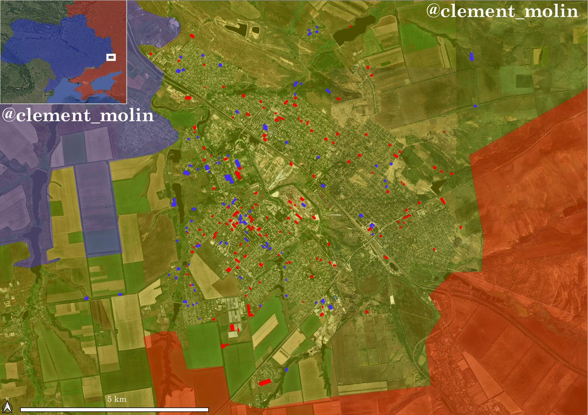
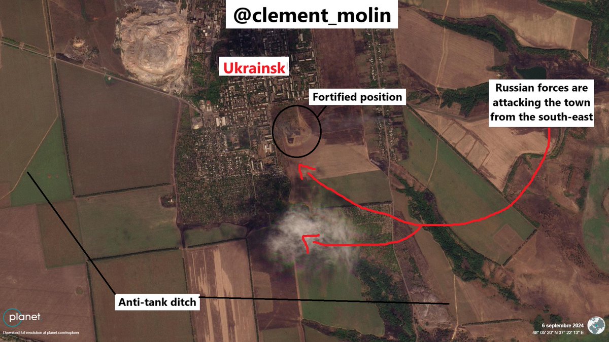
Here is a map of where all the Planet images are located. I choose to show the direct Pokrovsk direction. The next image is from the town of Ukrainsk, south of here.

Now, the russian army is trying to move southwards in the direction of Kourakhove. Since a few days, they are trying to enter Ukrainsk from the south-east, while bypassing the town on the road to Hrynk.
Ukrainian forces are now trying to push back russian infantry from Selydove.
New ukrainian units helped holding back the russian advance for the last week on the Pokrovsk direction, while russian army is launching new attacks on the Kourakhove-Vulhedar direction.
New ukrainian units helped holding back the russian advance for the last week on the Pokrovsk direction, while russian army is launching new attacks on the Kourakhove-Vulhedar direction.
According to @UAControlMap new units have been deployed to stop the advance :
2nd "Kara Dog" offensive brigade of the national guard, 93rd mechanized brigade.
And in the last month, 117th and 151st mechanized brigade, 14th NG, 71st Jager replaced other units.
2nd "Kara Dog" offensive brigade of the national guard, 93rd mechanized brigade.
And in the last month, 117th and 151st mechanized brigade, 14th NG, 71st Jager replaced other units.

Finally, after 2 months of Russian advances, (13km at least) in a highly fortified area, ukrainian brigades managed to hold the advance.
However, there are still large vulnerabilities on the defensive system : russian forces may advance along the railway to Pokrovsk and russian progress is still ongoing near Ukrainsk where the ukrainian are currently retreating from Nevelske.
16/16
However, there are still large vulnerabilities on the defensive system : russian forces may advance along the railway to Pokrovsk and russian progress is still ongoing near Ukrainsk where the ukrainian are currently retreating from Nevelske.
16/16

• • •
Missing some Tweet in this thread? You can try to
force a refresh