Geolocation 🧵
Israeli settlers armed with clubs attack and beat Palestinians and activists, inside the Bedouin Al-Kaabneh Elementary School, Al-Mu'arajat, Jericho, occupied #WestBank
31.914521, 35.404833
@GeoConfirmed
1/

Israeli settlers armed with clubs attack and beat Palestinians and activists, inside the Bedouin Al-Kaabneh Elementary School, Al-Mu'arajat, Jericho, occupied #WestBank
31.914521, 35.404833
@GeoConfirmed
1/
https://x.com/RamAbdu/status/1835609613032464658

(Vid. 2 & 3) Israeli settlers, armed with clubs, walking in Al-Mu'arajat, Jericho, occupied #WestBank
31.915141, 35.405175
2/
31.915141, 35.405175
2/
https://x.com/Mistaclim/status/1835631465356239236

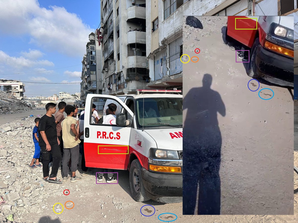
Later an injured Palestinian woman is brought to an ambulance at the same location, Al-Mu'arajat, Jericho, occupied #WestBank
31.915131, 35.405131
3/
31.915131, 35.405131
3/
https://x.com/IhabHassane/status/1835748924839039482

2 detained Palestinians with Israeli forces near the Bedouin Al-Kaabneh Elementary School, Al-Mu'arajat, Jericho, occupied #WestBank
31.915731, 35.403895
Photo 1: x.com/Mistaclim/stat…
Photo's: x.com/rafatdarawsheh…
Photo: x.com/QudsNen/status…
4/
x.com/IhabHassane/st… pic.x.com/Tx12X5v3l7
31.915731, 35.403895
Photo 1: x.com/Mistaclim/stat…
Photo's: x.com/rafatdarawsheh…
Photo: x.com/QudsNen/status…
4/
x.com/IhabHassane/st… pic.x.com/Tx12X5v3l7

Israeli soldiers and a settler in the Bedouin Al-Kaabneh Elementary School.
31.914555, 35.404745
Judging by clothing, the settler could be the same as one of the attackers in the other video.
Some kind of stick is also visible in his backpack.
5/
31.914555, 35.404745
Judging by clothing, the settler could be the same as one of the attackers in the other video.
Some kind of stick is also visible in his backpack.
5/
https://x.com/rafatdarawsheh/status/1835606421930446887


A settler, identified as Zohar Sabah in Al-Mu'arajat, Jericho, occupied #WestBank
Approx. 31.915004, 35.404823
What appears to be the same person is visible sitting on the ground in another video, geolocated above.
6/
Approx. 31.915004, 35.404823
What appears to be the same person is visible sitting on the ground in another video, geolocated above.
6/
https://x.com/saritm0/status/1835766052363591686


A far-right and Israeli settler Telegram channel also posted pictures of an injured settler, reportedly near Jericho.
t.me/elisha_yered/3…
I wasn't able to geolocate these photo's.
2 other pictures of the detained Palestinians were also posted there
t.me/elisha_yered/3…
7/
t.me/elisha_yered/3…
I wasn't able to geolocate these photo's.
2 other pictures of the detained Palestinians were also posted there
t.me/elisha_yered/3…
7/
In Oct, footage showing dolls covered in blood was geolocated next to the same school.
x.com/NemoAnno/statu…
In Jan. I geolocated footage of mock graves, reportedly dug by settlers also near the same school.
x.com/NemoAnno/statu…
8/
x.com/NemoAnno/statu…
In Jan. I geolocated footage of mock graves, reportedly dug by settlers also near the same school.
x.com/NemoAnno/statu…
8/
• • •
Missing some Tweet in this thread? You can try to
force a refresh