The operational situation is worsening for Ukraine🇺🇦 Armed Forces in the South Donetsk direction.
In the following days, Russia 🇷🇺 will reach Kourakhove and Ukraine will be forced to leave Vuhledar, its main stronghold on this front.
🧵THREAD🧵1/20 ⬇️
In the following days, Russia 🇷🇺 will reach Kourakhove and Ukraine will be forced to leave Vuhledar, its main stronghold on this front.
🧵THREAD🧵1/20 ⬇️

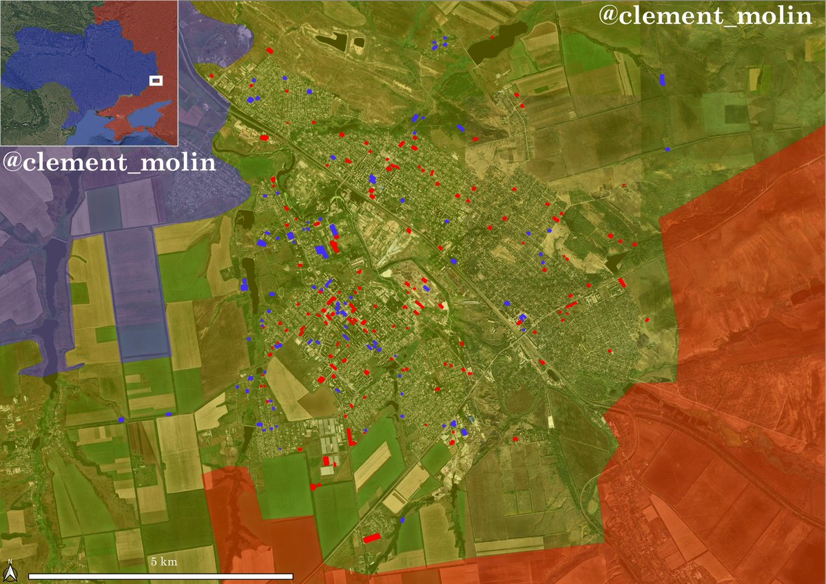
First, the general map for more context :
I'm french and most of my threads will be in french, so i'm sorry but you will have to translate most of them... (next ones will be in french).
I'm also writing for @atummundi, you can follow this account.
I'm french and most of my threads will be in french, so i'm sorry but you will have to translate most of them... (next ones will be in french).
I'm also writing for @atummundi, you can follow this account.

I still see many people saying the situation is under controll for Ukraine armed forces near Pokrovsk.
That's not totally true for Pokrovsk front itself. In the past week, Russia advanced to the edge of the third defensive line, taking the whole of Hrodivka city.
That's not totally true for Pokrovsk front itself. In the past week, Russia advanced to the edge of the third defensive line, taking the whole of Hrodivka city.

But if the situation on the Pokrovsk 'city' front is more or less under controll, it is not the case on the Pokrovsk/Kourakhove axis.
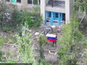
This video geolocated by shows a russian assault east of Ukrainsk, on a field where there are barely no scars of shelling t.me/creamy_caprice
This video geolocated by shows a russian assault east of Ukrainsk, on a field where there are barely no scars of shelling t.me/creamy_caprice
This happened west of the town of Ukrainsk Russia captured a few days ago. This progress put the Selydove stronghold in danger.
Moreover, there are no more defensive lines west of the railway.
Moreover, there are no more defensive lines west of the railway.

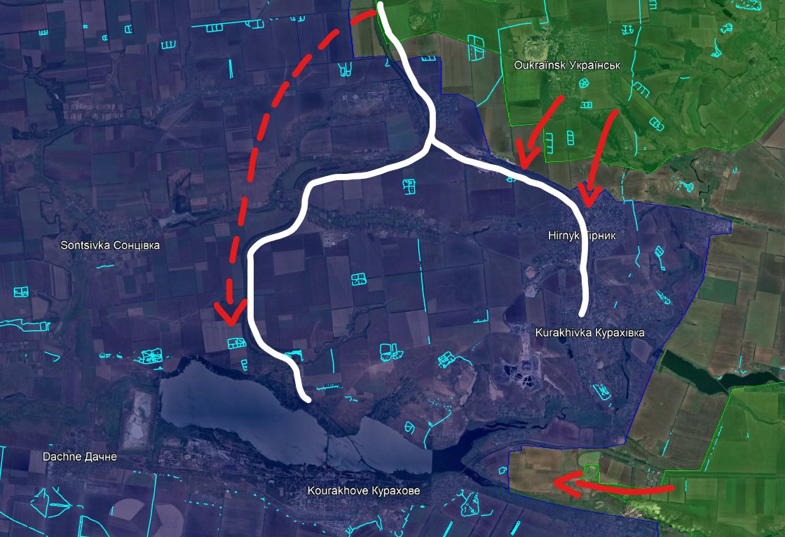
The Russian objective is not difficult to understand. They are now having a foothold on the railway. This will allow them to cross and try to reach the lake in Kourakhove.
Ukrainian positions in Hrynk and Kurakhivka may be forced to be abandonned.
Ukrainian positions in Hrynk and Kurakhivka may be forced to be abandonned.
A few days ago, I showed a map of fortified lines around Kourakhove. You can see the Andriivka and Kourakhove line are looking south.

And you can see the same thing near Pokrovsk : Russian progress south of Selydove near the railway is exactly at the east of the line south of Pokrovsk.

Based on geolocated footages from @UAControlMap by (@EjShahid and @klinger66) + @Deepstate_UA map, russian forces are present west of Hostre after multiple assaults.
They will soon cut the Kurakhivka-Kourakhove road.
Worst case scenario would be 🇷🇺 presence west of Kourakhove.
They will soon cut the Kurakhivka-Kourakhove road.
Worst case scenario would be 🇷🇺 presence west of Kourakhove.

Now, some videos from Vuhledar front. This is a very well defended frontline, maybe because units there are well trained and organized.
The first 2 videos show russian progress west of Vuhledar, and the third shows russian losses that are still high there.
The first 2 videos show russian progress west of Vuhledar, and the third shows russian losses that are still high there.
Based on @naalsio26 analysis, Russia lost 1 715 (1352 destroyed) vehicles on its Avdiivka-Pokrovsk-Kourakhove offensive. This data is from @WarSpotting, a very good source.
Ukraine lost 336 vehicles.
Among them, 780 AFV, 358 tanks and 73 trucks.
Ukraine lost 336 vehicles.
Among them, 780 AFV, 358 tanks and 73 trucks.

I use @WarSpotting and @lost_warinua maps to see where the geolocated losses are.
This a very good indicator of the situation at the front. For example, there are only few of them near Novohrodivka but many near Kourakhove.
This a very good indicator of the situation at the front. For example, there are only few of them near Novohrodivka but many near Kourakhove.


Vuhledar was a frontline city for more than 2 years. It held because it has dominant high rise buildings.
Since Russia took two of the 3 heights of the region (mine and factory), Ukraine will have to leave Vuhledar in the coming days/weeks.
Since Russia took two of the 3 heights of the region (mine and factory), Ukraine will have to leave Vuhledar in the coming days/weeks.

Here is a distrurbing map looking west to understand the overall russian offensive.
In a few days, we will reach the anniversary of the Avdiivka offensive, which soon become Pokrovsk offensive.
In a few days, we will reach the anniversary of the Avdiivka offensive, which soon become Pokrovsk offensive.

During the time, the objective changed a lot.
Russia first aimed at taking the whole Donetsk suburbs. They succeeded with high losses in Marinka, Krasnohorivka and Avdiivka.
But Ukraine did not have any plan after the fall of Donetsk suburbs.
Russia first aimed at taking the whole Donetsk suburbs. They succeeded with high losses in Marinka, Krasnohorivka and Avdiivka.
But Ukraine did not have any plan after the fall of Donetsk suburbs.
In 2014-2015, Ukraine failed to enter Donetsk and even lost Donetsk airport to russian forces.
They established themselves on the western suburbs and built formidable fortifications. However, nobody from 2014 to 2023 prepared solid fall back lines west of this line.
They established themselves on the western suburbs and built formidable fortifications. However, nobody from 2014 to 2023 prepared solid fall back lines west of this line.
Now, we just have to compare this to the north Donetsk : in 2022, formidable fortifications were erected all around Kramatorsk and Sloviansk.
Bakhmout was fortified, Siversk was fortified, Tchasiv Yar was fortified :
They are holding in the north but not in the south.
Bakhmout was fortified, Siversk was fortified, Tchasiv Yar was fortified :
They are holding in the north but not in the south.
The collapse of Donetsk city front began in june-august 2022.
Donetsk was a secondary frontline. Russia took Krasnohorivka north of Avdiivka, bypassing the defenses east of the town.
They entered Pisky, Opytne and Vodyane because there were not enough men there.
Donetsk was a secondary frontline. Russia took Krasnohorivka north of Avdiivka, bypassing the defenses east of the town.
They entered Pisky, Opytne and Vodyane because there were not enough men there.

I've been monitoring a few indicators to understand both russian objective and ukrainian defensive war :
-Fortifications
-Armoured/tank losses
-direction of progress
-bombing
For example, here is a Planet image from the 21st, showing a lot of russian bombing north of Novohrodivka. This suggest they are currently stopped and they are trying to destroy ukrainian positions along the railway before resuming their progress.

This is the end of the thread. The overall situation is more or less stable on other frontlines. A video emerged of a russian progress north of Niu York, I'm waiting for further proofs.
Russia is also closing in on Senkove in Kupiansk front (north-east).
20/20
Russia is also closing in on Senkove in Kupiansk front (north-east).
20/20

I'm also writing on other topics than Ukraine. Here is a french thread on the Sudan civil war, which is very difficult but very interesting to understand :
https://x.com/clement_molin/status/1837841223660241071
• • •
Missing some Tweet in this thread? You can try to
force a refresh