Dr. Daniel Swain Profile picture
Sep 28, 2024 19 tweets 3 min read Read on X
The images and stories just beginning to emerge from eastern TN and western NC in the aftermath of widespread catastrophic flooding wrought by #Helene are genuinely horrifying, and the full scale of the disaster is likely as yet untold. #TNwx #NCwx [Thread: 1/n]
20-30 inches--and perhaps locally 40+ inches--of rain fell along highest ridges of the Southern Appalachians due to 1-2 punch consisting of extreme "predecessor rain event" (PRE) that was historic in its own right followed by further extreme rain directly from #Helene. [2/n]
This was, by far, the most extreme rain event in observed record across much/most of the region, where reliable records date back over 100 yrs. Unsurprisingly, the flooding which resulted has also been widespread, historic, and generally catastrophic across a broad region. [3/n]
These floods, which were concentrated in valleys containing rivers and typically modest creeks and streams, involved extremely large volumes of water moving downhill at high velocity. This was not a gradual or "gentle" inundation by any means. [4/n]
From footage that has emerged, it's clear that some smaller towns and some neighborhoods within larger population centers were essentially wiped off the map--with many/most structures in these areas completely destroyed and even washed away. [5/n]
Most, if not all, major roadways in the region remain impassable. Multiple major highways and even interstates will likely be closed for weeks to months as major bridges have been severely damaged/destroyed and many embankments/hillslopes have eroded or collapsed. [6/n]
For a time yesterday, it appeared that multiple substantial and "high hazard" dams might fail entirely--sending large walls of water downstream and presenting an even greater disaster. Fortunately, it appears that catastrophe was narrowly averted--but only just. [7/n]
Nevertheless, it's already clear that human toll is high & will likely rise further once access & telecommunications are gradually restored. This is a major regional flood disaster on a scale we haven't seen in some time in U.S., & many communities have been devastated. [8/n]
I'm writing this thread for a few reasons. First, I think it's important to recognize that this event is a disaster of national significance and will require large-scale response in both short and long term. "No news" is not good news in this case--quite the opposite. [9/n]
Also, for my West Coast audience, I wanted to reflect on this event in the context of #ARkStorm 2.0--a hypothetical but plausible catastrophic flood scenario we've developed for California, with the intent of improving preparedness and planning for such an event. #CAwater [10/n]
The Sep 2024 event in Southern Appalachians has had "ARkStorm-level" impacts in eastern TN & western NC. Widespread, catastrophic flooding has resulted; many lives have been lost; transport, electric, telecomm infrastructure is devastated; some towns are completely isolated. [11/n]
These are the type and magnitude of impacts we would likely see during an ARkStorm-like event in California. It's possible such effects could be even more widespread, and affect more people, than this Southern Appalachian disaster, but the general point holds. [12/n]
I & others who have worked on ARkStorm's multiple iterations over the years have received quite a bit of pushback from a variety of sources: "This is ridiculous; it could never happen!" "California gets droughts & wildfires, not floods!" "You're such a fearmonger!" & etc. [13/n]
Those criticisms are, of course, not based in any kind of observable scientific reality! Consider, for example, California's Great Flood of 1862 (or any number of even larger events that lurk in the paleoclimate record). It's a question of when, not if, in the long run. [14/n]
But I this speaks to a common refrain--one that becomes particular dangerous on a warming Earth and amid a non-stationary climate: "It can't/won't happen here!" "If it does happen here, it won't be that bad." "This town's been here for 150 years--we've seen everything already!" [15/n]
That's not to say that climate change is solely responsible for this or any other disaster, of course, although there are crystal clear links between climate warming and consequential increases in precipitation extremes (particularly the most severe events--like this one). [16/n]
As always, other factors are also at play: Expanding populations into known & extant floodplains as well as artificial modification of river channels; old and crumbling infrastructure built decades ago; differential societal exposure via economic inequity, and etc. [17/n]
But sometimes "worst case" scenarios really do come to pass, and I think we often lack the collective imagination to fully envision what that looks like. That's a problem, because being honest about risks that exist is first step toward mitigating them & preventing harm! [18/n]
Ultimately, there many folks in FL, GA, NC, & TN who are in need of urgent assistance--and that is/should be foremost priority. But to those insisting that "this is not the time!" to have those other conversations, I say: This is *exactly* when we need to be having them. [19/n]

• • •

Missing some Tweet in this thread? You can try to force a refresh
 

Keep Current with Dr. Daniel Swain

Dr. Daniel Swain Profile picture

Stay in touch and get notified when new unrolls are available from this author!

Read all threads

This Thread may be Removed Anytime!

PDF

Twitter may remove this content at anytime! Save it as PDF for later use!

Try unrolling a thread yourself!

how to unroll video
  1. Follow @ThreadReaderApp to mention us!

  2. From a Twitter thread mention us with a keyword "unroll"
@threadreaderapp unroll

Practice here first or read more on our help page!

More from @Weather_West

Jan 17
After becoming increasingly enmeshed in the wildfire world, you start to notice things about the way we've systematically altered our relationship with the natural environment in a way that has increased the risk of destructive fires. And then you stop being able to unsee them.
I've always lived in the American West, in different parts of California and on the Colorado Front Range. I've traveled throughout the West extensively; even as a child, fire was always there in the distance--a companion on family roadtrips, a backdrop to summer afternoons.
One of my earliest memories (fuzzy though it is; I was very young) was ash falling from the sky while out at a San Francisco park. The date? October 20, 1991--the day the devastating Oakland Hills fire tore through around 3,000 structures and killed 25 in the Berkeley Hills.
Read 23 tweets
Jan 11
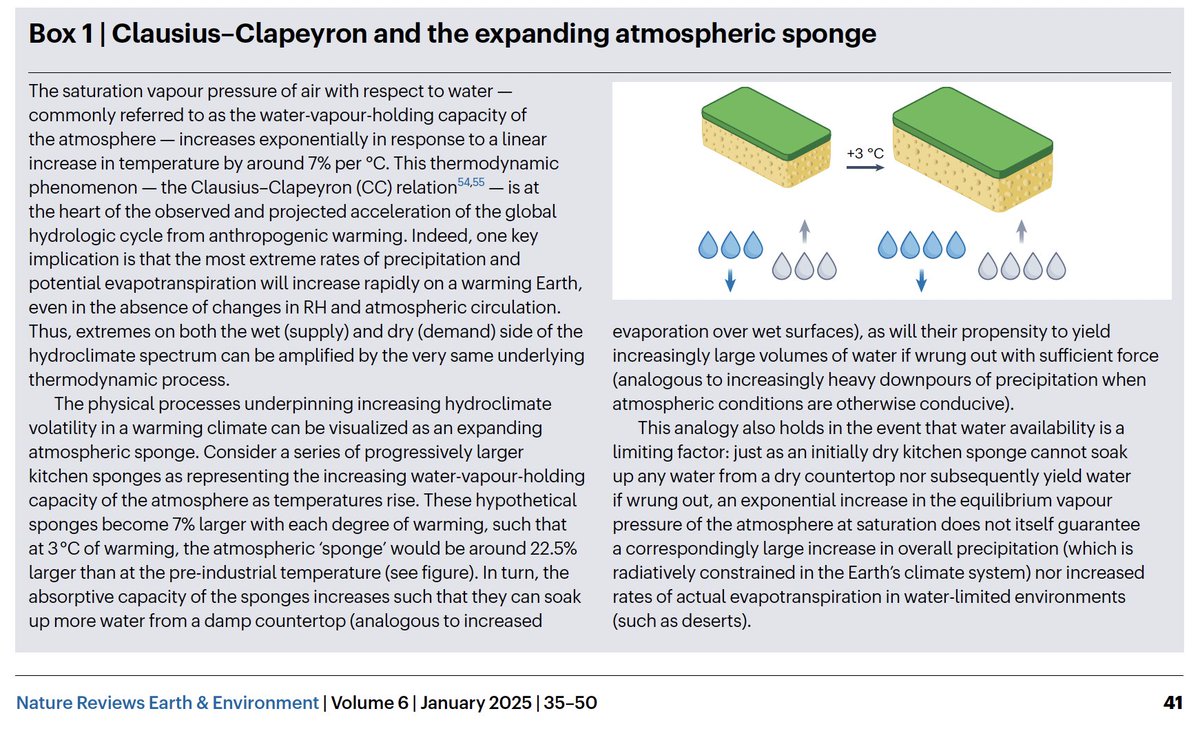
Our paper on "Hydroclimate volatility on a Warming Earth" is out in Nature Reviews Earth & Environment. We assess existing scientific literature & conduct new analysis--concluding that "#HydroclimateWhiplash" is increasing due to #ClimateChange. [Thread] nature.com/articles/s4301…
"Hydroclimate volatility" refers to rapid transitions between unusually wet & dry conditions relative to local baseline. For quantitative analysis, we define a new "hydroclimate whiplash" metric using Standardized Precipitation & Evaporation Index (SPEI). nature.com/articles/s4301…Figure 1 from Swain et al. 2025. Caption: Location, date and impacts of select hydroclimate whiplash events from 2016 to 2023, and the corresponding magnitude of changes in the Standardized Precipitation Evapotranspiration Index (SPEI; shading). The brown shades represent wet-to-dry events and green shades dry-to-wet events. The events do not represent a comprehensive catalogue of all whiplash events but are illustrative of the breadth and diversity of geographies subject to such rapid transitions. Societally and ecologically consequential hydroclimate whiplash events can occur in virtually...
One key aspect of the framework for understanding such volatility is that it encompasses both "supply" & "demand" side of water balance--that is, not only precipitation (or lack thereof), but also evaporation (or evaporative demand). Precipitation doesn't tell the whole story!
Read 16 tweets
Jan 9
Is there a link between #ClimateChange & increasing risk/severity of #wildfire in California--including the still-unfolding disaster? Yes. Is climate change the only factor at play? No, of course not. So what's really going on? [Thread] #CAfire #CAwx #LAfires iopscience.iop.org/article/10.108…
There is rarely, if ever, a singular cause of complex disasters--so don't be fooled by disingenuous "straw man" binaries! For wildfire, encroachment into high risk areas, historical land management, & climate all matter (to contextually varying degrees). theguardian.com/environment/20…
What is the primary link between #ClimateChange and wildfire, both in CA specifically and more broadly globally? Vegetation moisture, and therefore its flammability (which includes propensity to ignition, combustion intensity, rates of spread, and etc.). nature.com/articles/s4155…
Read 23 tweets
Jan 1
Apropos of recent, ah, speculation...a few thoughts about #fog.

Fog is, simply, a shallow cloud that extends all the way to the ground. It's usually composed of condensed water droplets--though "ice fog," composed of ice crystals, can occur if it's cold enough. [Thread: 1/10]
#Fog usually forms when air cools to its dew point (i.e., when temperature decreases & relative humidity reaches 100%, causing air to become saturated,) and the air can no longer "hold" additional water vapor, which condenses out as (visible!) liquid droplets. [Thread: 2/10]
There are several processes that can cool air to its dew point & create #fog, including warm, moist air moving over a cool surface ("advection fog"), cold air moving over warm water ("steam fog"), and rapid cooling of the Earth's surface at night ("radiation fog"). [Thread: 3/10]
Read 10 tweets
Dec 14, 2024
A few notes on this morning's #Tornado Warning for San Francisco from @NWSBayArea (I am still traveling, so my live interactions are still somewhat limited):

1) Yes, a formal warning was issued by NWS for San Francisco this AM based on a suggestive radar signature. #CAwx [1/7]
@NWSBayArea 2) So far as I know, this was indeed first such warning ever issued for SF proper (but not first tornado in SF!). Other similar warnings have been issued elsewhere in Bay Area under similar conditions (i.e., offshore waterspout potentially moving ashore as tornado). #CAwx [2/7]
@NWSBayArea In 2005, for example, an EF1 tornado occurred in South Francisco, causing some notable damage. Other more significant tornado events have occurred elsewhere in the Bay Area and NorCal; although rare, they are not unprecedented. #CAwx [3/7]sfgate.com/bayarea/articl…
Read 7 tweets
Nov 18, 2024
A strong, prolonged, very moist, and relatively warm #AtmosphericRiver event, in conjunction with rapidly-strengthening #BombCyclone (yes, that's the term!), will bring major rain (and, locally, wind) impacts to OR/NorCal this week. Flooding is likely. #CAwx #ORwx #CAwater [1/6] Snapshot of 3-day accumulated IVT (integrated vapor transport) along the West Coast of North America from the GFS model. It depicts extremely high 72-hr accumulated IVT values aimed at far northern California coast.
First, a low pressure system west of OR and WA will undergo explosive deepening (rapid strengthening, known as "bombogenesis") over the next 2 days. It may become one of the strongest low pressure systems on record in this region. (~940mb) #CAwx #ORwx #CAwater [2/6] A map plot depicting the relative anomalousness of surface pressures over the northeastern Pacific Ocean later this week. There is a region of red west of WA and OR, indicating that the upcoming storm may bring some of the lowest surface pressures on record in this region.
This very strong low will generate hurricane-force sustained winds well offshore (& 50-60ft+ waves!). The strongest winds will remain well offshore, but damaging 70-90 mph gusts will still be possible in coastal OR & perhaps along far North Coast of CA. #CAwx #ORwx #CAwater [3/6] A plot showing predicted maximum wind gusts over time for Gold Beach, Oregon. Each horizontal strip depicts a different ensemble member from the ECMWF ensemble. Nearly all members depict wind gusts over 70mph during this event, with some approaching or exceeding 90 mph.
Read 7 tweets

Did Thread Reader help you today?

Support us! We are indie developers!


This site is made by just two indie developers on a laptop doing marketing, support and development! Read more about the story.

Become a Premium Member ($3/month or $30/year) and get exclusive features!

Become Premium

Don't want to be a Premium member but still want to support us?

Make a small donation by buying us coffee ($5) or help with server cost ($10)

Donate via Paypal

Or Donate anonymously using crypto!

Ethereum

0xfe58350B80634f60Fa6Dc149a72b4DFbc17D341E copy

Bitcoin

3ATGMxNzCUFzxpMCHL5sWSt4DVtS8UqXpi copy

Thank you for your support!

Follow Us!

:(