New: 2 rapid attribution studies on the impact of climate change on Hurricane #Helene have just been released. The results are very significant, yet unsurprising.
Warmer air, warmer water = much heavier rainfall rates. First study: ~50% increase in rain in parts of NC/ GA!! 🧵
First from @MichaelFWehner, who is one of the World’s experts on the connection between climate warming and Tropical cyclones.
“…our best
estimate is that climate change caused over 50% more rainfall during Hurricane Helene in some
parts of Georgia and the Carolinas.” 2/
@MichaelFWehner “Furthermore, we estimate that the observed rainfall was
made up to 20 times more likely in these areas because of global warming.”
That’s study number 1. Now let’s discuss study number two…
3/
@MichaelFWehner Analysis from Climameter: “Climate change made the heavy rainfall from Hurricane Helene up to 20% more intense and the strong winds up to 7% stronger than they were at the end of the century, according to a new analysis by a group of researchers from Climameter.” 4/
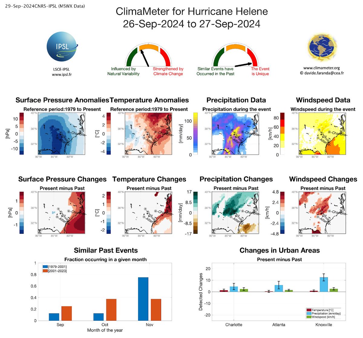
@MichaelFWehner Here’s the link to the Climameter study:
Now some commentary from me in the next tweet… 5/climameter.org/20240926-27-hu…
@MichaelFWehner Me: #Helene was a very unique event. The main driving force of the flooding in NC was tropical moisture being forced into mountainous terrain! First a “predecessor event” saturating the ground and then a fast moving hurricane slamming into the mountains, spiking rain rates 6/
So this disastrous flooding would have occurred regardless of climate change, just from natural factors alone.
However, the record hot Gulf and baseline warmer atmosphere enhances the heaviest tropical rain rates by much greater than the Clausius–Clapeyron relation. 7/
C-C says 8% more moisture per 2F increase in temperature.
For a more comprehensive explanation ask/ follow @MichaelFWehner
As you may suspect both the dewpoint in FL (surface moisture) and more importantly the precipitable water (total column moisture) in June have been trending up.
For every 1F increase in temperature, the column can hold 4% more moisture. We have warmed ~3F since pre-industrial 1/
Wow now have the capacity for ~12% more moisture. Thus the capacity to fuel more frequent/intense rain. In some cases more moisture means more instability, thus stronger storms & rain rates. Per @MWehner2005 CC spiked Harvey by up to 38%, w/ CC's share of the damage $13B 2/
@MWehner2005 The Gulf is record warm because: the baseline has been warmed by climate change - and- the historic heat dome over Mexico & the Gulf which made for hot/ cloud free weather. The Gulf is a big player in dewpoint and also rainfall rates, a likely contrubuter to FL's extreme rains 3/
25,000 years ago this is how Florida’s coastline looked. Sea level was 427 ft lower with all the water locked up in miles-thick ice at the peak of the last ice age. If you lived in Tampa you’d needed to walk 100 miles W to go to the beach. Follow along on this very educational🧵
This is what it looked like at the last glacial maximum. Ice spread all the way down to NYC and Chicago. If you go to Central Park in NYC you can see the edge of where they ended, there are huge boulders there. These ice ages have occurred every ~100K years recently. Here’s why…
Earth’s tilt, orbit and wobble change on the order of 10s of 1000s of yrs. Milankovitch Cycles. This changes amount of solar radiation received and where the sunlight hits, gradually changing Earth’s avg temp over 1000s of years, leading to ice ages and warm periods. Here’s…
This image is astonishing for both the message it communicates and for its sci comm value. Incredible work by team @CopernicusEU
It shows global ocean temps for each year since 1940. The alarming, yet brilliant part is the pink shading which highlights the 2023-2024 jump 1/
From 2023-2024 all areas in deep red were record warm. A huge area.
In May 2024 that record hot area was ~25%, so 1/4 of our planet. Huge amount. 2/
The avg global temp of the past 12 months was 1.63 above pre-industrial levels (~3 degrees F).
IPCC says this warming is 100% due to humans unequivocally.
While this spike above the Paris goal of 1.5C maybe be temporary (that is to be seen), we are super close to exceeding it 3/
Putting aside the Gulf Loop Current, speaking more generally about warming water, in a perfect environment (moist, low shear) for every 3F of sea sfc warming, a strong hurricane’s wind speeds can inc. 20%. So a 150 mph storm, can grow to 180mph storm, and damage pot. ⬆️ 67% 1/
Sea sfc temps across the Gulf & Carib are ~3F warmer than a few decades ago. That’s one reason we should care about a warming world.
The example I use is based on an already strong hurricane in a nurturing environment, but it can happen. Source for calc: michaelmann.net/sites/default/…
Notice the destructive potential increases exponentially as winds increase. According to Mann’s paper a 1C boost yields 12% wind boost and 40% potential damage boost.
A strong storm one category more intense (all other things being equal) can more than double the damage. 3/
“The climate always changes”… that’s true. Over tens of thousands of years Earth’s tilt changes a bit and so does Earth’s orbit around the sun… sometimes closer to a circle, sometimes an ellipse. This changes the amount of sunlight Earth receives and thus Earth’s avg temp 🧵 1/
As a result of orbital changes, every ~100,000 years the Earth sees an ice age. In between - where we are now - are warm periods called interglacials. Notice the difference is only 10 degrees F!
Those changes are natural and generally gradual.
But a century ago that changed 2/
Global average temps have been fairly stable over the past 10K years, with some regional cool and warm periods. But in the past several decades temps spiked (red on right) at a rate >10X the natural rate of anything we’ve seen in millions of years. 3/
The science behind this weekend’s 265 mph jet stream! A trans Atlantic flight reached an astonishing 835 mph. So Lets talk about meteorology, how climate change factors in and not breaking the sound barrier… 🧵 1/
The reason: two jets converge into 1 over the US and a sharp contrast of frigid vs warm air enhance the wind.
The result: a 265 mph upper level jet helps boost a Newark to Lisbon flight to peak speed of 835 mph reaching Lisbon in 5:44…. About an hour faster than normal! 2/
Odd that this story has repeat a few times in the last few years, record flight speeds? Climate change? Recent paper found that for every +1C in temp = 2% inc. in jetstream speed (plus 2.5X for fastest winds). We are at +2C now so that’s 10% boost. Roughly 240 becomes 275 mph 3/