Round-up of verified Iran ballistic missile strike videos:
1. A strike in Glilot, Tel Aviv, possibly near Mossad headquarters, verified by @TwistyCB (POV: 32.162814, 34.814391)
2. A crater in Glilot, Tel Aviv, also possibly near Mossad headquarters, possibly the result of the strike seen in video 1. Verified by @fab_hinz (32.148475, 34.80782)
@fab_hinz 3. A second video documenting the crater shown in video two at the same location
4. A strike on the north side of Tel Aviv, seen near Ayalon Mall, verified by @NemoAnno. (POV: 32.098561, 34.828177)
5. A strike on the north side of Tel Aviv, verified by The Post, @TwistyCB and others. Possible that this is the same strike shown in multiple videos near Mossad headquarters. (POV: 32.086607, 34.769713)
@TwistyCB 6. A strike on Nevatim Airbase, verified by The Post, @JakeGodin and others. One of the heaviest documented so far.
7. Another view of the strike on Nevatim Airbase, verified by @GeoRaccoon. (POV: 31.218534, 34.859118)
8. Crater and damage near a school in Gedera, verified by @nemoanno. (Location: 31.802099, 34.787821)
9. Another view of the strike on Nevatim Airbase, verified by @JakeGodin. (POV: 31.076197, 35.028013)
10. Impacts on or near Ort Tel Nof airbase, verified by @TwistyCB. (POV: 31.833837, 34.857067)
(Reminder to check out @GeoConfirmed and everyone named in this thread for more verifications and proofs.)
11. @nickschifrin reports from the crater near Mossad headquarters shown in videos two and three
Our new investigation (linked below) finds that nearly 6,000 buildings have been damaged or destroyed in southern Lebanon, around 80% of them since Israel’s Oct. 1 invasion. I’ll go into some of our findings and work here 🧵:
To conduct this analysis, we relied on @coreymaps and @jamonvdh’s excellent damage maps and estimates, which are based on Sentinel-1 satellite radar analysis. Combined with Microsoft building footprints, they allow you to make a map of damage (in red) that can look like this:
Scher and Van Den Hoek's satellite radar analysis provides a country-wide view of damage that often picks up signals that can't be seen with the naked eye, even on very high resolution optical imagery (for reasons the experts understand much better than me).
Earlier this month, I read Ezra Klein's interview with Franklin Foer, the author of a recent sweeping piece in The Atlantic looking back at the Biden administration's Gaza policy, in which Foer made an interesting claim about Biden's "red line" on Rafah in March.
Klein pointed out that Biden said invading Rafah would be a red line, and then Israel went ahead and did it anyway. Foer replied that, from the Biden team's perspective, they did enforce the red line, by making Israel alter its invasion plan and do it in a "pinpoint way."
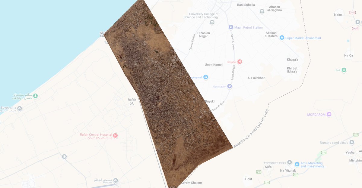
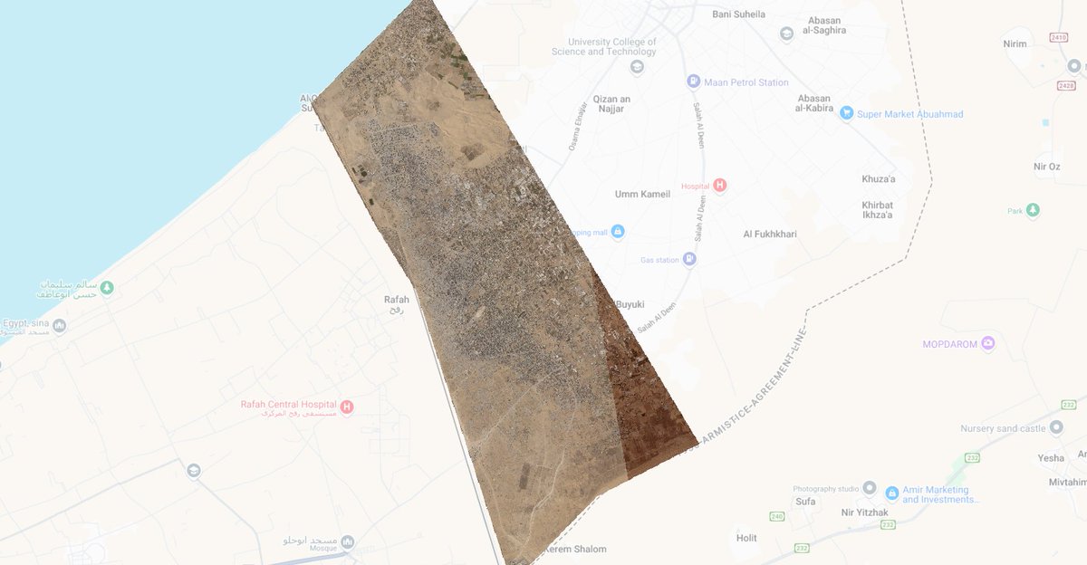
That struck me as odd, thinking back on what happened in Rafah, so I checked the satellite imagery. On the left is Rafah before the invasion, on May 5. On the right is Rafah after major combat ended, on September 12.
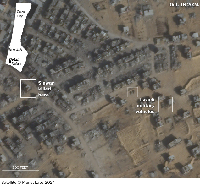
Hamas leader Yahya Sinwar was killed in a house in Rafah’s devastated Tel al-Sultan refugee camp, around 170 meters from active Israeli military positions, according to @planet satellite imagery and visuals released by the IDF: washingtonpost.com/world/2024/10/…
@JakeGodin geolocated the house where Sinwar was killed:
The IDF outpost, composed of earthen berms, seems to have been created and in use since late last month. This video, posted by soldier on Sept. 26 and geolocated by @NemoAnno, shows him driving by the house where Sinwar would be killed and parking there: t.me/amitsegal/38288
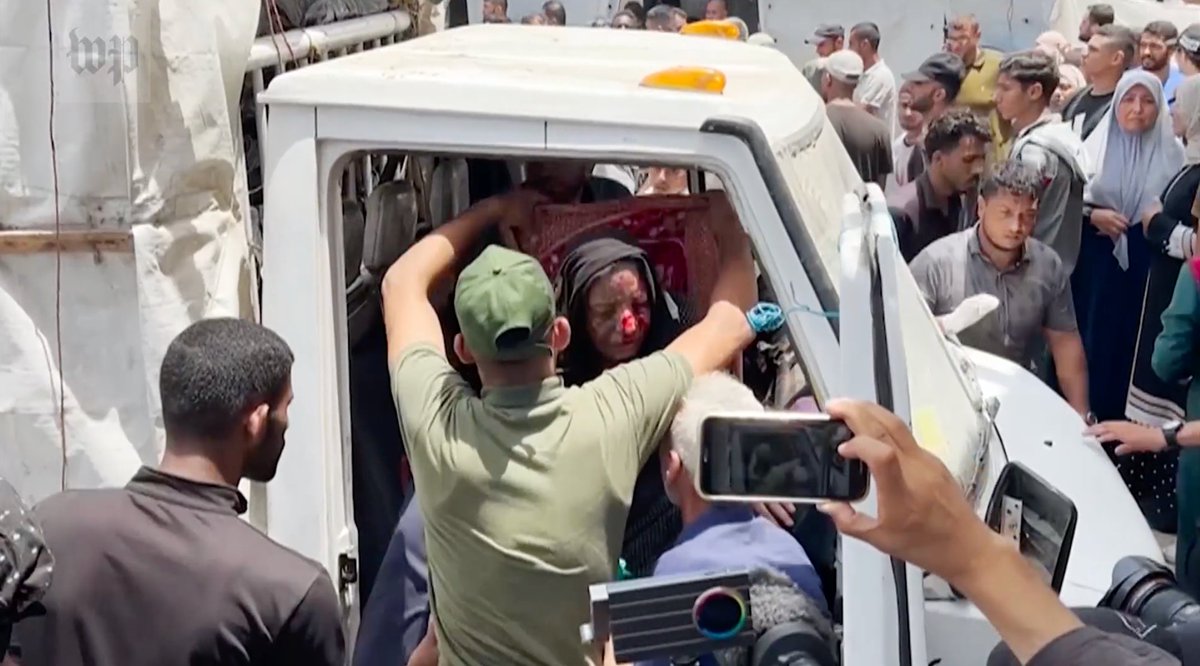
On June 8, the Israeli military employed heavy airstrikes across a densely populated Gaza refugee camp during a midday hostage rescue operation, killing scores of Palestinians. Our new investigation reconstructs one of the deadliest days of the war: wapo.st/4fEws61
The Post reviewed and mapped more than 100 videos and photos, spoke to 19 witnesses and analyzed satellite imagery to reconstruct the raid, which killed 274 Palestinians, according to the Gaza Health Ministry.
The Israeli military said that fewer than 100 people were killed during the raid, and like the Gaza Health Ministry, it did not distinguish between combatants and civilians.
New: Two sources and a Post video analysis reveal how a local police officer, shooting from the ground a little over 100 meters away, fired a key first shot at Trump shooter Thomas Crooks, after which Crooks never fired again: wapo.st/3WI7Ul3
A member of Butler County's SWAT team, standing outside behind the stage and using an M4 rifle, fired a shot at Crooks from around 110 meters away less than a second after Crooks ended a volley of eight shots, The Post found.
Video filmed near the roof where Crooks was shooting shows him turn away from the rally after that shot, then reposition himself, possibly to take aim again.
Ten seconds pass, then a Secret Service countersniper kills Crooks with one shot.
The Post analyzed videos, satellite imagery and terrain to build a 3D model and reconstruct Trump's attempted assassination. We found multiple security gaps, including obstructed views and a failure to prevent the shooter from accessing the roof 🧵wapo.st/3Lwyt6k
How Thomas Matthew Crooks got onto the roof a little more than 400 feet from Trump remains unclear, but it was the day's first and arguably biggest failure. Bystanders spotted him crawling up the roof about two minutes before he opened fire, and tried to warn police:
Multiple videos show police officers and police vehicles near the building from which Crooks fired in the moments before gunfire erupts: