GeoConfirmed UKR - Investigation
When Ukraine undertakes offensive operations, Russia attempts to manipulate/influence the information environment.
For nearly three years, we have been monitoring the war in Ukraine, and another notable trend has emerged:
whenever Ukraine initiates an offensive operation, social media becomes inundated with claims of significant Ukrainian losses. However, we have observed that these claims often consist of disinformation: they may reference outdated losses, incidents from different regions, or even Russian losses reported as Ukrainian losses... (I kid you not).
This misinformation is often compiled in a way that suggests Ukraine's offensive efforts are failing, thereby attempting to sway public perception.
Recently, as Ukraine commenced an offensive operation (January 4th, 2025), again bold claims were made about Ukrainian losses.
We took a few days to investigate two specific assertions: one from a relatively small account named @NewRulesGeo and another from 'North Wind,' a Russian channel associated with the military.
The thread by NewRulesGeo garnered over 4 million views, while the post by North Wind attracted nearly 100,000 views on Telegram.
As anticipated, the reality is not as it appears.
For an account calling itself NewRulesGeo, it is striking that the individual does not grasp that geolocation is accurate. A significant portion of their thread is unrelated to the newly launched Kursk operation; it includes either older footage, irrelevant content, or different videos of the same vehicle being attacked while implying they depict different vehicles, and they guess the outcome of strikes without any proof.
Some of the footage was indeed from the recent Ukrainian offensive operations in Kursk Oblast, and by mixing it with unrelated material, they attempt to enhance their credibility. This is a well-known technique in spreading disinformation: combining accurate information with falsehoods. People tend to recognize the accurate claims and, as a result, may assign greater credibility to the entire narrative, including the disinformation.
Regarding the North Wind post, the considerable number of vehicles shown at the end of their video are actually Russian vehicles destroyed in mid-December. They misrepresent their own losses as Ukrainian losses.
We prefer not to invest too much time in debunking disinformation, as a lie can be made in just a few minutes, but the debunking can cost you days.
For example, this fact-check took us several days and the effort of a few dedicated volunteers.
I want to thank volunteers @giK1893, @99Dominik_, @moklasen and @GeoRaccoon for their geolocation work, making this thread possible.
We hope our fact-checking thread receives more than 4 million views, because mis-/ and disinformation is a plague on X and Facts DO Matter.
1/20

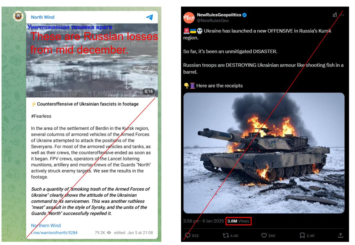
We will start by the North Wind claim.
"In the area of the settlement of Berdin in the Kursk region, several columns of armored vehicles of the Armed Forces of Ukraine attempted to attack the positions of the Severyans. For most of the armored vehicles and tanks, as well as their crews, the counteroffensive ended as soon as it began. FPV crews, operators of the Lancet loitering munitions, artillery and mortar crews of the Guards "North" actively struck enemy targets. We see the results in the footage.
Such a quantity of "smoking trash of the Armed Forces of Ukraine" clearly shows the attitude of the Ukrainian command to its servicemen. This was another ruthless "meat" assault in the style of Syrsky, and the units of the Guards "North" successfully repelled it."
Ironically, the large number of losses depicted starting at 0:29 are Russian losses incurred during their offensive in mid-December while attacking Ukrainian-occupied territory in Kursk from the west.
Source: t.me/warriorofnorth…
Full video.
2/20

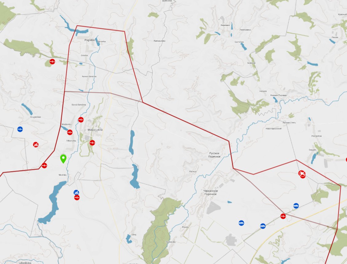
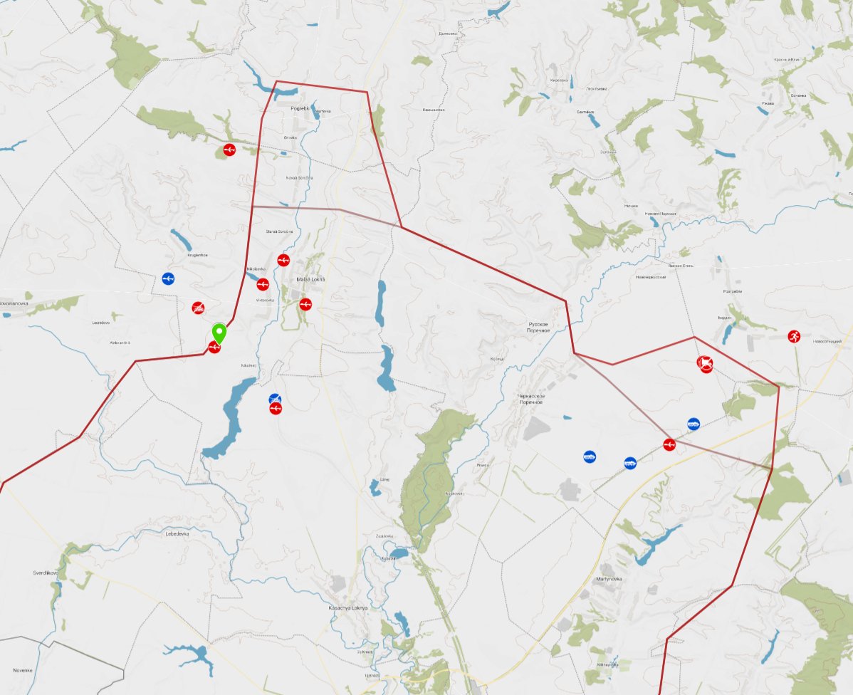
Proof:
Geolocation: 51.311532, 35.063038
Great factchecking by @giK1893 in this thread: x.com/giK1893/status…
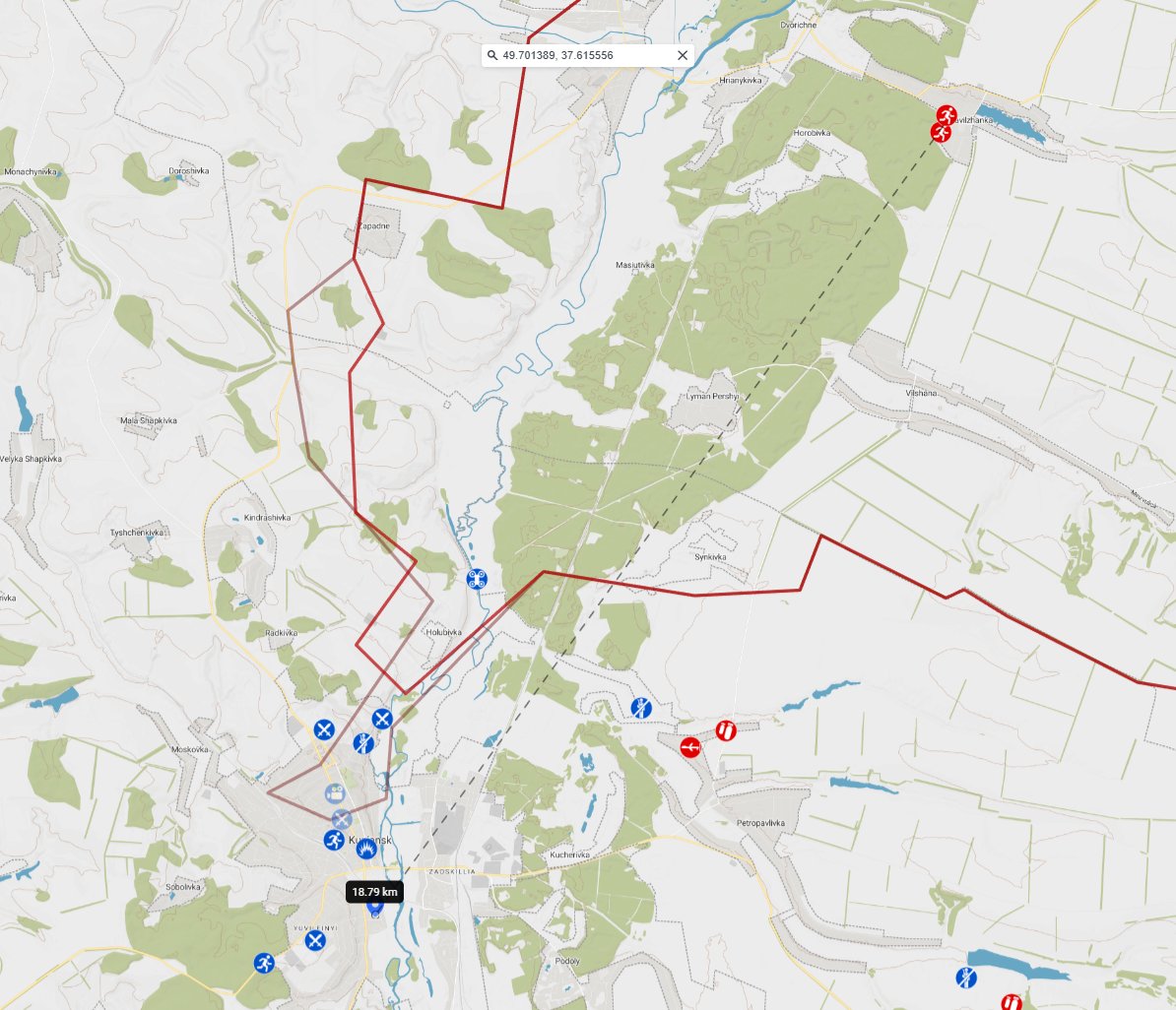
Picture one:
Geolocation of the Russian losses:
- based on the information provided by ukr.warspotting.net:
ukr.warspotting.net/view/32650/ ukr.warspotting.net/view/32569/ ukr.warspotting.net/view/32961/ ukr.warspotting.net/view/32642/
- based on a video of the Ukrainian 36th Marine Brigade , published 17 December 2024, the showing all the Russian losses in the region: t.me/ua_marines_36b…
Picture two:
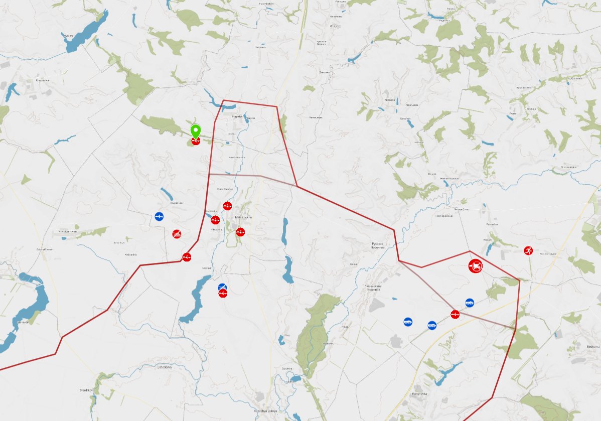
Green circle: Russian losses mid-December
Blue arrows: Ukrainian offensive operations which started January 4th, 2025.
Video: Russian losses filmed by the Ukrainian 36th Marine Brigade, published 17 December 2024
Conclusion: North Wind has presented Russian losses from mid-December, misrepresenting them as Ukrainian losses from the recent offensive. Geolocation analysis has confirmed that this footage does not even originate from the area of the recent offensive.
3/20
Geolocation: 51.311532, 35.063038
Great factchecking by @giK1893 in this thread: x.com/giK1893/status…
Picture one:
Geolocation of the Russian losses:
- based on the information provided by ukr.warspotting.net:
ukr.warspotting.net/view/32650/ ukr.warspotting.net/view/32569/ ukr.warspotting.net/view/32961/ ukr.warspotting.net/view/32642/
- based on a video of the Ukrainian 36th Marine Brigade , published 17 December 2024, the showing all the Russian losses in the region: t.me/ua_marines_36b…
Picture two:
Green circle: Russian losses mid-December
Blue arrows: Ukrainian offensive operations which started January 4th, 2025.
Video: Russian losses filmed by the Ukrainian 36th Marine Brigade, published 17 December 2024
Conclusion: North Wind has presented Russian losses from mid-December, misrepresenting them as Ukrainian losses from the recent offensive. Geolocation analysis has confirmed that this footage does not even originate from the area of the recent offensive.
3/20


The NewRulesGeopolitics claim.
Almost 4 million views.
We have analyzed every tweet in our fact-checking thread. We use screenshots to ensure that no source footage has been altered.
There are 15 tweets, some of which contain multiple videos.
Tweet 1.
Important for tweet 1 is that you need to notice that his thread is about the new offensive in Kursk region, claiming it's a disaster and destroying Ukrainian armor like a fish in a barrel.
Tweet 1 - Analysis.
The text is to draw attention with bold claims and a picture that is made by Grok. That's how he tries to draw attention to his thread, and it worked...
After called out for the fake imagery he placed a tweet explaining himself:
x.com/NewRulesGeo/st…
Conclusion Tweet 1: Fake picture and bold -not yet proven- claims.
4/20

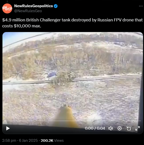
Tweet 2:
$4.9 million British Challenger tank destroyed by Russian FPV drone that costs $10,000 max.
x.com/NewRulesGeo/st…
---
Analysis Tweet 2:
A Ukrainian armoured vehicle hit by two Russian FPV drones, result unclear.
51.2953, 35.217309
76W8+4W7 Nikol'skii, Kursk Oblast, Russia
GeoLocated by @moklasen
Geolocation: x.com/moklasen/statu…
Location: geoconfirmed.org/ukraine/7da739…
Sources: Vid1
(1/2)
x.com/moklasen/statu…
t.me/rustroyka1945/…
Vid2
(2/2)
x.com/moklasen/statu…
t.me/rustroyka1945/…
Referenced footage of another incident used to geolocate:
x.com/moklasen/statu…
t.me/rustroyka1945/…
Conclusion Tweet 2:
6km and 12 km from the contact lines related to the Ukrainian offensive operations.
Not certain if its even hit/damaged/destroyed, based on this footage.
5/20
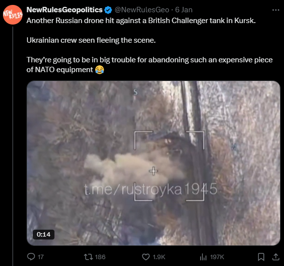
Tweet 3:
Another Russian drone hit against a British Challenger tank in Kursk. Ukrainian crew seen fleeing the scene. They’re going to be in big trouble for abandoning such an expensive piece of NATO equipment.
x.com/NewRulesGeo/st…
Analysis Tweet 3:
This is the same tank as the one above. This tank is attacked at least three times with drones. The tank is hit, but the final result is unclear.
Conclusion Tweet 3:
Two tweets to show that one (1) Ukrainian tank, is attacked at least 3 times with Russian FPV drones, and the tank was 6 and 13 km from both Ukrainian offensive axis. Unclear if tank was destroyed.
6/20
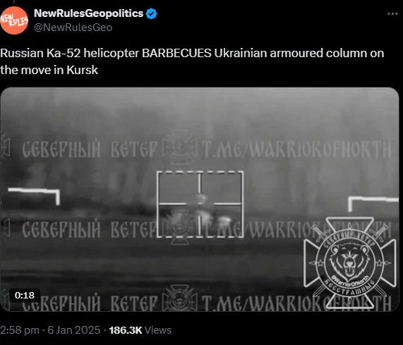
Tweet 4:
Russian Ka-52 helicopter BARBECUES Ukrainian armoured column on the move in Kursk
x.com/NewRulesGeo/st…
Analysis Tweet 4.
It is impossible to conduct a proper geolocation or accurately assess what is depicted here. The source is North Wind, and given the quality of their assessments (sarcasm intended), as noted at the beginning of our thread, this footage could be from any location. It may be true, or it may not be.
Conclusion Tweet 4:
Showing grainy footage with very bold claim that is impossible to prove based on the footage. The source has been proven untrustworthy.
7/20
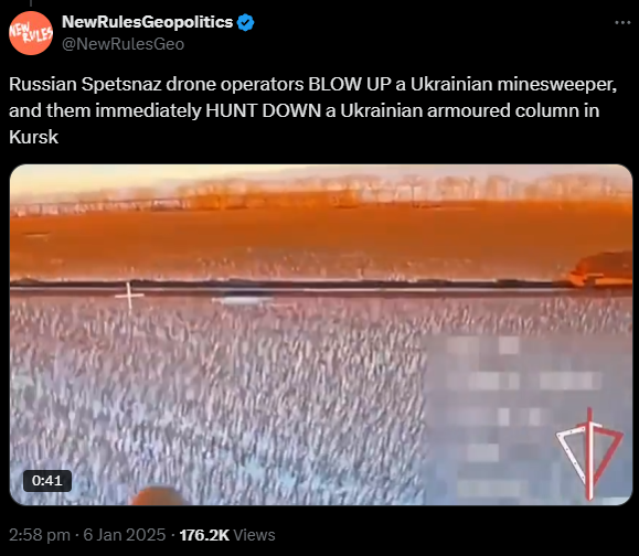
Tweet 5:
Russian Spetsnaz drone operators BLOW UP a Ukrainian minesweeper, and them immediately HUNT DOWN a Ukrainian armoured column in Kursk.
x.com/NewRulesGeo/st…
Analysis Tweet 5:
This footage consists of 3 different frames:
Frame 1:
0:00-0:27 - Ukrainian WiSENT 1 (mine clearing vehicle) hit by a Russian FPV drone with fiber-optic cable, result unclear.
51.303784, 35.407007
8C34+GR6 Berdin, Kursk Oblast, Russia
0:28-0:35 - The same WiSENT 1 as above, hit by a Russian FPV drone with fiber-optic cable, result unclear.
51.307664, 35.406637
8C54+3M6 Berdin, Kursk Oblast, Russia
0:35-End - Ukrainian tank hit by a Russian FPV drone with fiber-optic cable, result unclear.
51.28944, 35.39949
79QX+QQH Kruglik, Kursk Oblast, Russia
GeoLocated by @GeoRaccoon and @moklasen
Geolocation: (1) x.com/GeoRaccoon/sta…
(2)
x.com/moklasen/statu…
(3) x.com/GeoRaccoon/sta…
Sources: x.com/NOELreports/st…
x.com/Zlatti_71/stat…
t.me/RosgvardOffici…
(1/3) x.com/WarVehicle/sta…
Conclusion Tweet 5:
3 different frames, based on geolocation, showing the offensive maneuver in the direction of Berdin, Kursk Oblast. In this footage we see the same WiSENT 1 being hit by two Russian fiber-optic drones and a tank being hit by one Russian fiber-optic drone. In both cases the result is unclear. "BLOW UP?'' is another unproven claim.
8/20
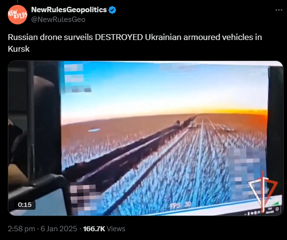
Tweet 6:
Russian drone surveils DESTROYED Ukrainian armoured vehicles in Kursk
x.com/NewRulesGeo/st…
Analysis Tweet 6:
Ukrainian armoured vehicle burning and one vehicle attacked by an FPV Suicide drone, during the Ukrainian offensive operation in the direction of Berdin, Kursk Oblast.
Burning vehicle - 51.297164, 35.407061
7CW4+VR7 Berdin, Kursk Oblast, Russia
Rough location of the attacked vehicle - 51.29707, 35.40608
7CW4+RCG Berdin, Kursk Oblast, Russia
GeoLocated by @GeoRaccoon
Geolocation: x.com/GeoRaccoon/sta…
x.com/GeoRaccoon/sta…
Sources: x.com/GeoRaccoon/sta…
t.me/RosgvardOffici…
Secondary sources, showing same incident from other angle)
x.com/GeoRaccoon/sta…
t.me/pograni4nik_iz…
Conclusion Tweet 6:
Based on geolocation, showing the offensive maneuver in the direction of Berdin, Kursk Oblast.
In this footage we see a destroyed, burning, vehicle and another vehicle being hit by a fiber-optic drone.
Contrary to the claim, only one vehicle is visibly destroyed.
9/20
Tweet 7.
Ukrainian soldiers films aftermath of Russian drone strike against Ukrainian column in Kursk. Absolutely brutal 🤙
x.com/NewRulesGeo/st…
Analysis Tweet 7:
We were not able to geolocate this yet. The original footage is shared by @Harri_Est ( x.com/Harri_Est/stat…) on X in the early morning of January 4th. Also two ambulances are visible, meaning this is highly likely in the rear. Based on the timing and the two ambulances, it's likely not related to the Ukrainian offensive operation, but it still could be. Impossible to prove without geolocation.
Our team is looking further into this.
Conclusion Tweet 7:
Unknown geolocation, likely not related to the Ukrainian offensive operation, unless proven otherwise by -for example- geolocation.
10/20

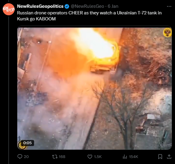
Tweet 8.
Russian drone operators CHEER as they watch a Ukrainian T-72 tank in Kursk go KABOOM.
x.com/NewRulesGeo/st…
Analysis Tweet 8:
A Ukrainian T-64BV tank destroyed by a Russian FPV drone with fiber-optic cable.
51.160883, 35.303758
5863+9G2 Makhnovka, Kursk Oblast, Russia
GeoLocated by @giK1893
Geolocation: x.com/giK1893/status…
Gear ID:
t.me/lost_warinua/1…
Location: geoconfirmed.org/ukraine/27e8c0…
Sources: Vid1 (January 3th, 2025)
x.com/giK1893/status…
t.me/rusich_army/19…
Vid2
x.com/99Dominik_/sta…
t.me/veterany_60oms…
Conclusion Tweet 8:
Unrelated to the Ukrainian offensive operation: Footage was published before the start of that operation and the location is in Makhnovka, Kursk Oblast, Russia, far away from the Ukrainian offensive and during the Russian offensive on this area.
11/20
Tweet 9.
Russia’s 155th Marine Brigade is SLAPPING DOWN Ukrainian invaders in Kursk right and left.
x.com/NewRulesGeo/st…
Analysis Tweet 9:
3 videos.
Video 1:
Ukrainian BTR-4E hit by a Russian FPV drone with fiber-optic cable, result unclear.
51.312685, 35.20596
8674+39G Nikol'skii, Kursk Oblast, Russia
GeoLocated by @moklasen
Geolocation: x.com/moklasen/statu…
Sources: x.com/RALee85/status…
t.me/rustroyka1945/…
---
Video 2:
This is the same tank as his tweet 2 & 3.
---
Video 3:
A Ukrainian armoured vehicle attacked by a Russian FPV drone, result unclear.
Rough location of presumed impact - 51.312123, 35.190128
856R+R3R Nikol'skii, Kursk Oblast, Russia
GeoLocated by @moklasen and @GeoRaccoon
Geolocation: x.com/moklasen/statu…
x.com/GeoRaccoon/sta…
Sources: x.com/markito0171/st…
x.com/front_ukrainia…
t.me/rustroyka1945/…
(1/2)
x.com/Tendar/status/…
---
Conclusion Tweet 9:
Video 1:
Not part of the Ukrainian offensive operations.
Not certain if its even damaged/destroyed, based on this footage.
Video 2: Same tank as tweet 2&3
Video 3: Not part of the Ukrainian offensive operations, result unclear.
Thus, the initial claim about "slapping down" is once again heavily exaggerated.
12/20

Tweet 10.
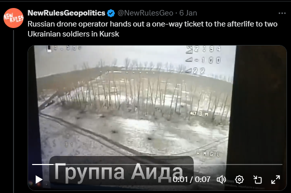
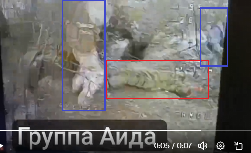
Russian drone operator hands out a one-way ticket to the afterlife to two Ukrainian soldiers in Kursk
x.com/NewRulesGeo/st…
Analysis Tweet 10:
What is assessed as a Russian FPV drone strike on two Ukrainian soldiers taking a Russian soldier prisoner.
Rough location of impact in minute 0:05 - 51.30814, 35.405654
8C54+772 Berdin, Kursk Oblast, Russia
GeoLocated by @moklasen
Geolocation: x.com/moklasen/statu…
Sources: x.com/moklasen/statu…
t.me/iamsniper/9859
---
Conclusion Tweet 10:
Related to the offensive. It is a Russian dug-out and what is assessed as a Russian soldier is lying on the ground the moment the drone impacted.
13/20
Tweet 11.
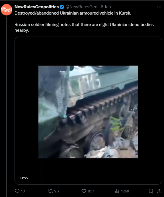
Destroyed/abandoned Ukrainian armoured vehicle in Kursk. Russian soldier filming notes that there are eight Ukrainian dead bodies nearby.
x.com/NewRulesGeo/st…
Analysis Tweet 11:
Not geolocated yet. But comparison of footage proves that this is the same vehicle reported by lost_warinua t.me/lost_warinua/8… at August 12, 2024.
Conclusion Tweet 11:
Not related to the offensive. Footage from mid-August.
14/20

Tweet 12.
Russian drone operators MURK American Stryker vehicle in Kursk
x.com/NewRulesGeo/st…
Analysis Tweet 12:
Not yet geolocated, accurately assess what is depicted here is also difficult based on this grainy footage.
Conclusion Tweet 12.
Showing grainy footage with bold claim that is impossible to prove based on the footage. Could be related to the offensive. Or not.
15/20

Tweet 13.
Russian paratroopers capture American M577 command post carrier in Kursk
x.com/NewRulesGeo/st…
Analysis Tweet 13:
Damaged/destroyed and captured Ukrainian M577 command post carrier at the gas station in Korenevo. This is de M557 that was destroyed at 2 Nov 2024 near 51.362000, 35.085111 (Location by lost-warinua)
51.426967, 34.885596
CVGP+Q6Q Korenevo, Kursk Oblast, Russia
GeoLocated by @budeshta and @99Dominik_
Geolocation: x.com/budeshta/statu…
x.com/99Dominik_/sta…
Sources: x.com/99Dominik_/sta…
t.me/vdvpskov/6347
t.me/vdvpskov/6345
Gear ID:
t.me/lost_warinua/9…
Conclusion Tweet 13:
This is a left behind, in November 2024, captured Ukrainian M777, and not related to the Ukrainian offensive operation.
16/20

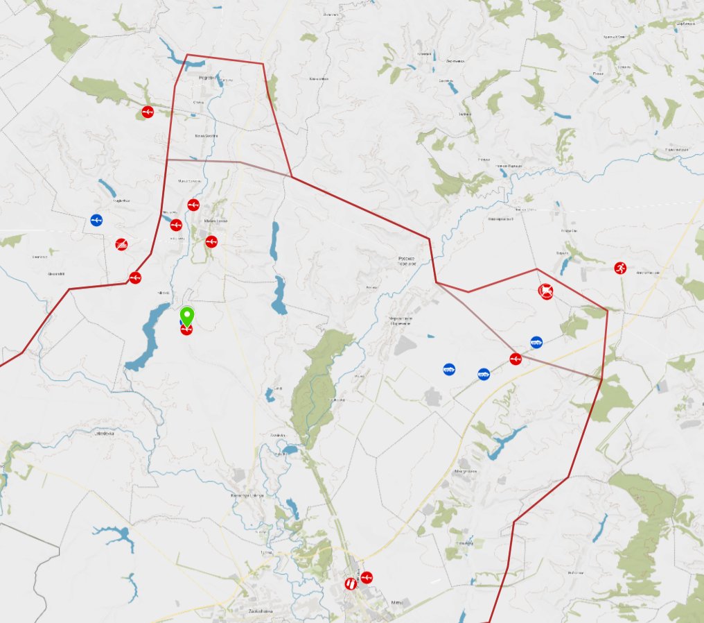
Tweet 14:
Ukrainian troops try to evacuate wounded comrades in Kursk. Russian drone spots them and HUNTS THEM DOWN.
x.com/NewRulesGeo/st…
Analysis Tweet 14:
Ukrainian soldiers attacked by a Russian FPV drone with fiber-optic cable during CASEVAC, result unclear.
Location of presumed impact - 51.366462, 35.196908
958W+HQM Pogrebki, Kursk Oblast, Russia
GeoLocated by @moklasen
Geolocation: x.com/moklasen/statu…
Sources: x.com/moklasen/statu…
x.com/distant_earth8…
x.com/militar_ru/sta…
t.me/Irishstrike/84
Conclusion Tweet 14:
Related to the second axis of Ukrainian offensive operations.
17/20

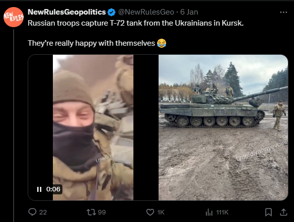
Tweet 15.
Russian troops capture T-72 tank from the Ukrainians in Kursk. They’re really happy with themselves 😂
Analysis Tweet 15:
Location not yet found, but published January 1st.
Conclusion Tweet 15:
Not related to the Ukrainian offensive operation.
18/20
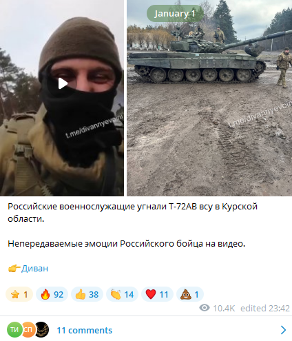
Russian troops capture T-72 tank from the Ukrainians in Kursk. They’re really happy with themselves 😂
Analysis Tweet 15:
Location not yet found, but published January 1st.
Conclusion Tweet 15:
Not related to the Ukrainian offensive operation.
18/20
https://x.com/NewRulesGeo/status/1876267202296562020
Conclusion:
Post by North Wind showing Russian losses from mid December, claiming they are Ukrainian.
---
Thread by @NewRulesGeo:
Tweet 1: Fake picture.
Tweet 2, 3 and 9 (video 2): same tank, NOT related to the Ukrainian Offensive, based on location.
Tweet 4: Could be related to the Ukrainian Offensive. Showing grainy footage with very bold claim that is impossible to prove based on the footage. The source has been proven untrustworthy.
Tweet 5: Related to the Ukrainian Offensive, showing two drone strikes on the same vehicle and an attack on another.
Tweet 6: Related to the Ukrainian Offensive, showing one burning vehicle and a drone strike on another.
Tweet 7: Doubtfully related to the Ukrainian Offensive, based on the publication timing and two visible ambulances.
Tweet 8: NOT related to the Ukrainian Offensive, based on location.
Tweet 9: NOT related to the Ukrainian Offensive: besides showing the same tank attacked for the third time (Video 3), neither of the three videos are related to the Ukrainian Offensive, based on location.
Tweet 10: Related to the Ukrainian Offensive, showing an FPV strike on two Ukrainians and what is assessed as a Russian POW.
Tweet 11: NOT related to the Ukrainian Offensive
Tweet 12: Could be related to the Ukrainian Offensive. Showing grainy footage with bold claim that is impossible to prove based on the footage.
Tweet 13: NOT related to the Ukrainian Offensive
Tweet 14: Related to the Ukrainian Offensive, second axis.
Tweet 15: NOT related to the Ukrainian Offensive
---
Recap:
"Ukraine has launched a new OFFENSIVE in Russia’s Kursk region. So far, it’s been an unmitigated DISASTER. Russian troops are DESTROYING Ukrainian armour like shooting fish in a barrel."
Out of the 15 tweets...
FOUR (4) are related, TWO (2) could be related, ONE (1) is doubtfull. Meaning 8 are NOT RELATED.
Those 7 show: 1 burning vehicle, 3 vehicles being attacked by drones (some vehicles multiple times), some soldiers being attacked by drones. And then some unproven claims. And one doubtfully (if related to the offensive) video showing killed Ukrainian soldiers.
A significant portion of the thread is unrelated to the newly launched Kursk operation; it includes either older footage, irrelevant content, or different videos of the same vehicle being attacked while implying they depict different vehicles, and they guess the outcome of strikes without any proof.
---
Final Conclusion:
When Ukraine undertakes offensive operations, Russia attempts to manipulate/influence the information environment, this is again proven by this thread.
For nearly three years, we have been monitoring the war in Ukraine, and another notable trend has emerged:
whenever Ukraine initiates an offensive operation, social media becomes inundated with claims of significant Ukrainian losses.
However, we have observed that these claims often consist of disinformation: they may reference outdated losses, incidents from different regions, or even Russian losses reported as Ukrainian losses...
By mixing proven information with unrelated material, they attempt to enhance their credibility.
This is a well-known technique in spreading disinformation: combining accurate information with falsehoods. People tend to recognize the accurate claims and, as a result, may assign greater credibility to the entire narrative, including the disinformation.
This information is often compiled in a way that suggests Ukraine's offensive efforts are failing, thereby attempting to sway public perception.
Always stay vigilant for manipulation, mis- and disinformation, especially about war related topics.
FACTS do MATTER.
19/20
If you like our work you can buy us a coffee.
This helps:
Improving our maps and user interface.
Improving data management.
Buying Sat Img for confirmations and investigations.
More information about our work:
World: geoconfirmed.org/world (460+)
Ukraine: geoconfirmed.org/ukraine (38750+)
Sahel: geoconfirmed.org/sahel (760+)
Syria: geoconfirmed.org/syria (950+)
Israel: geoconfirmed.org/israel (5250+)
Yemen: geoconfirmed.org/yemen (100+)
Myanmar: geoconfirmed.org/myanmar (650+)
Cartel Map: geoconfirmed.org/cartel (290+)
Thanks to all our volunteers all over the world! buymeacoffee.com/geoconfirmed
20/20
• • •
Missing some Tweet in this thread? You can try to
force a refresh