Thread with satellite imagery of the California wildfires.
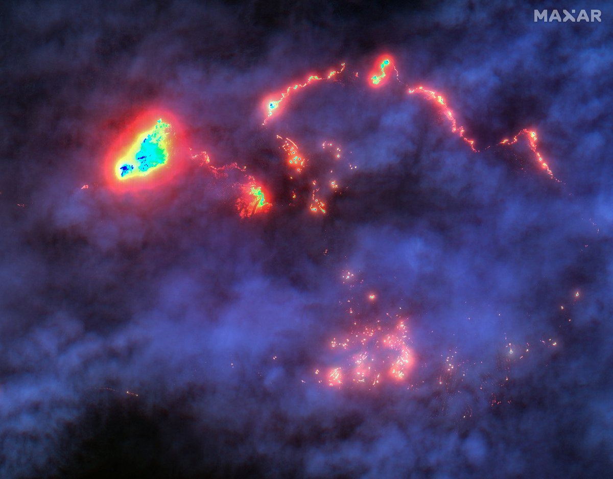
Smoke and clouds largely obscured the northwestern sections of the LA suburbs (Palisades, Malibu), but shortwave infrared (SWIR) sensor helps penetrate that and extensive damage and hundreds of active fires can be seen. Location: 34.045, -118.540. 🛰️📸: @Maxar
@Maxar By blending the SWIR image of today with an older (pre-fires) optical image, it's possible to see where the fires are burning compared to the houses. This is The Summit neighborhood, Pacific Palisades. Location: 34.074, -118.563. 🛰️📷: @Maxar
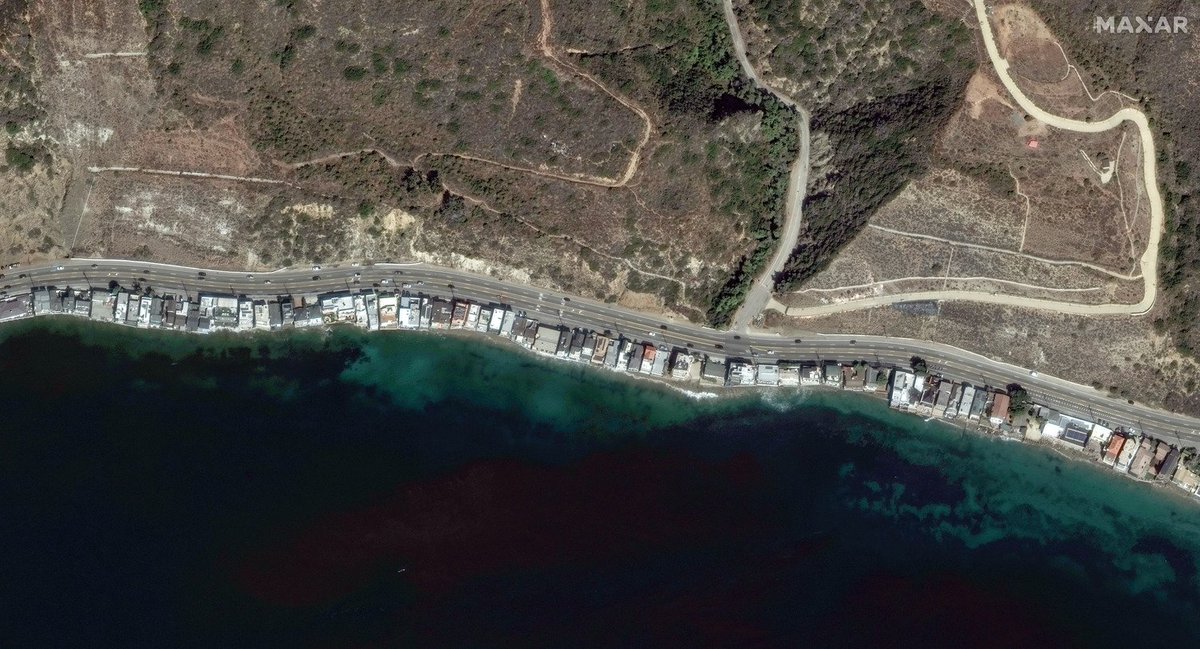
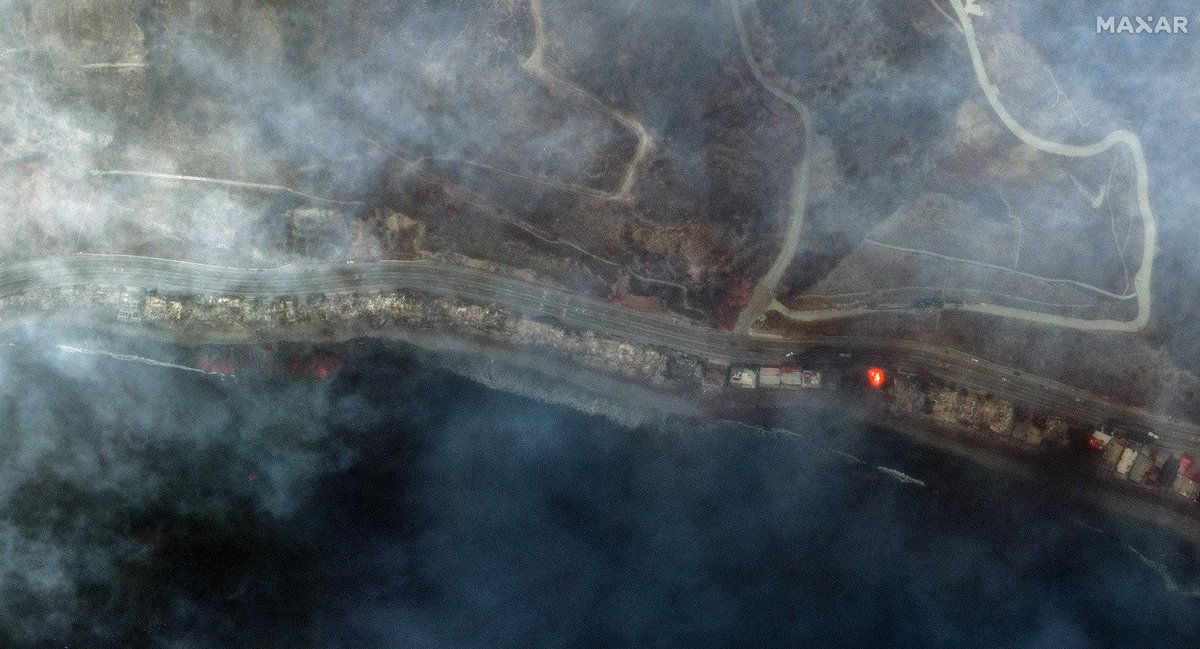
Before/after view of burning and destroyed houses along Pacific Coast Highway (location: 34.039, -118.589 ). 🛰️📷: @Maxar google.com/maps/@34.04061…
@Maxar Overview of Eaton Fire burning in and near Altadena, California (location: 34.187, -118.108 ). 🛰️📷:
@Maxar google.com/maps/@34.18699…
SWIR images of burning homes in Altadena (location: 34.187, -118.108 ). 🛰️📷:
@Maxar google.com/maps/place/34%…
Before/after view of burning and destroyed houses near Fair Oaks Avenue, Altadena (34.194, -118.151). 🛰️📷:
@Maxar
Before/after view of burning and destroyed houses and businesses along East Altadena Drive ( 34.191, -118.130). 🛰️📷: @Maxar
Before/after view reveal extensive burning and widespread house destruction near Marathon Road, Altadena (34.199, -118.140). 🛰️📷: @Maxar
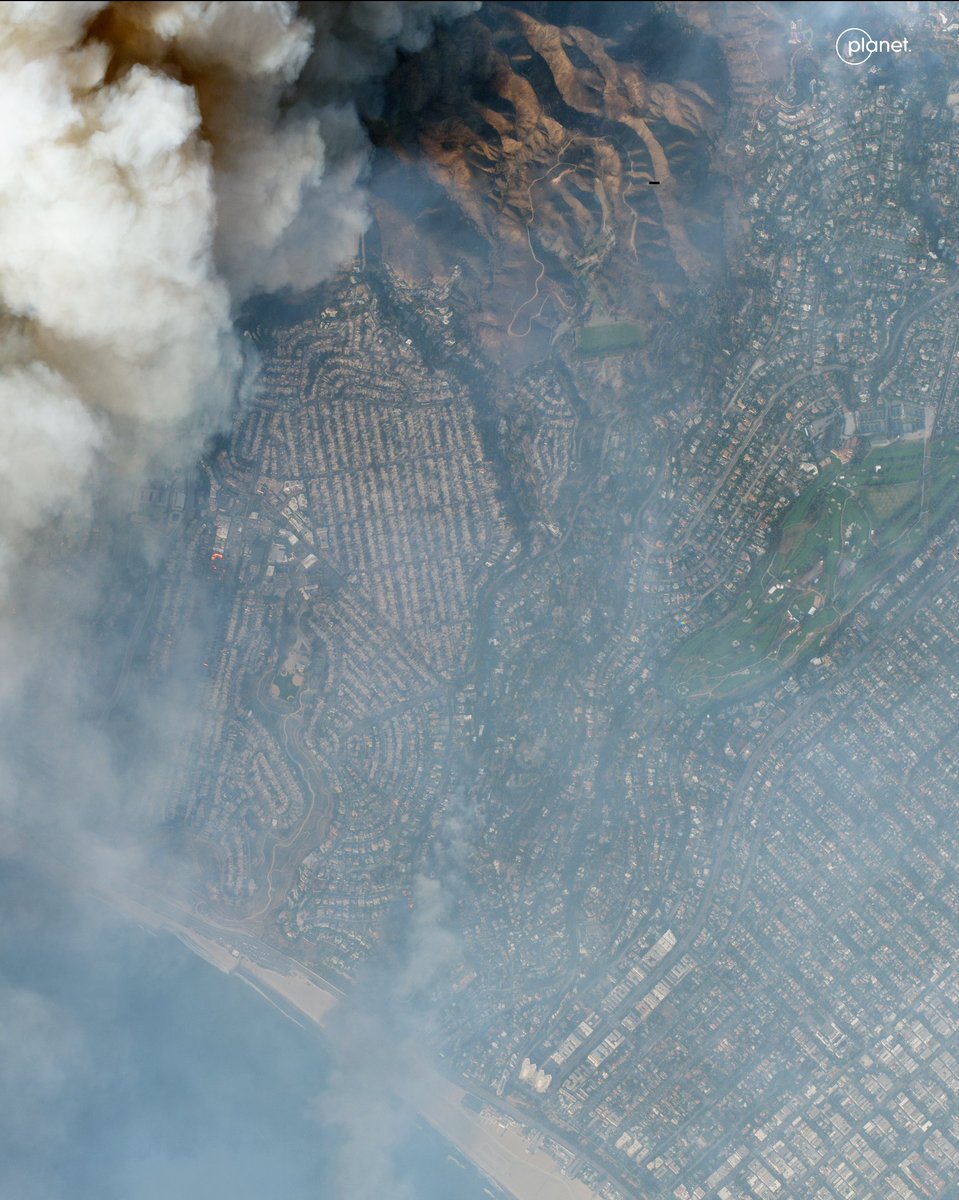
@Maxar This image, taken by @planet 's SkySat, shows the Palisades fire (location: 34.0472, -118.5127). Visible are the neighborhoods of North of Montana, Riviera, and Rustic Canyon.
@Maxar @planet This optical image, also via @planet, shows The Summit neighborhood in the Palisades as well. Quote-tweet shows the @Maxar image SWIR/optical blend.
Six fires now menace Los Angeles. Firefighters were already struggling to fight the worst blaze in the city's history, and more than 100,000 people were under mandatory evacuation orders. More on @nytimes: nytimes.com/live/2025/01/0…
NEW: On the first day of the war with Iran, the United States used a new ballistic missile. It was untested in combat. Our analysis shows it struck a sports hall, an elementary school, and residential areas — killing at least 21 people, including children. w/ @johnismay
Here's a gift link to our full story. We analyzed security camera videos, aftermath photos, satellite images and mapping services. We're citing experts (i.e. @ArmsControlWonk) and referencing other reporting on this (i.e. by @neginbagheri91, @ChrisOsieck, @MerlynThomas, @Shayan86, @jalalisarah, @MerlynThomas, @DropSiteNews): nytimes.com/2026/03/29/wor…
The missile in question is the Precision Strike Missile (PrSM, pronounced like “prism”), a short-range ballistic missile designed to replace Army Tactical Missile System (ATACMS). Lockheed Martin just announced it's expanding the production. lockheedmartin.com/en-us/news/fea…
New footage reveals an apparent U.S. or Israeli strike near a boys' school in Abyek, west of Tehran, on Feb. 28. Satellite imagery suggests a comms tower was the intended target, but flying debris killed a child on the playground. Story w/ @Parinlalala nytimes.com/2026/03/09/wor…
The footage originates from multiple security cameras. It shows an ordinary morning; boys playing on the playground. It's just hours after the first joint U.S.-Israeli strikes, so school are in session. Then, an explosion is seen at the top of the screen.
We geolocated the footage to the Imam Reza Elementary School for boys in Abyek, a small city in the Qazvin Province, west of Tehran: 36.045062, 50.542351. The footage from the interior shows the blast damaged the school itself too.
What you're looking at is not a sunrise — it's the Russian LNG tanker ARCTIC METAGAZ (IMO 9243148) struck by a massive explosion in the Mediterranean this morning. Photographed by crew aboard a merchant vessel, via Vanguard Tech.
Photos were taken ~04:00 local (03:00 UTC), looking towards Libya. ARCTIC METAGAZ had been running dark (AIS off, see @MarineTraffic screenshot) but had traveled southeast of Malta before the explosion (150NM per Maltese media, h/t @malte_humpert @sanjanamv @DefMon3).
At the time of the suspected (naval) drone attack, the ARCTIC METAGAZ was fully loaded near Murmansk with about 4 tanks of LNG, per @Kpler data. That's probably about $50 to $60 million worth in Russian gas.
We obtained the first known satellite image of Ayatollah Ali Khamenei's compound in Tehran. There are several destroyed buildings. While the current whereabouts of Iran's supreme leader are unknown, the compound is generally used as his official residence. 🛰️📸: @Airbus
*first publicly released satellite image
Either way, it goes to show that triangulating the lines of sight from four geolocated videos lead precisely to a main strike location in Tehran.
Israel has launched a daylight attack on Tehran, just now. Multiple explosions have been reported in Iran's capital. It isn't clear yet what was targeted, so starting a thread with geolocations.
This photo, showing thick smoke plumes, was taken from Hasan Abad Square (میدان حسنآباد), looking northwest. Reference photo attached (). @GeoConfirmed: 35.686144, 51.410156. google.com/maps/@35.68614…
@GeoConfirmed This video, posted by a semi-official Iranian news agency, shows thick smoke rising near Pasteur St (خیابان پاستور), where key government institutions are located. Point-of-view is southwest. Geolocation in tweet below.
The aftermath of the Jan. 8 fire in the historic bazaar of Rasht, northern Iran, is visible in satellite imagery. The image is accessible via @Soar, a relatively new free platform aggregating satellite data from multiple sources, including @CopernicusEU.
The fire broke out amid nationwide anti-government protests, and Rasht's bazaar was a focal point of unrest, including clashes and strikes by merchants. Iranian authorities blame protesters for setting the fire, eyewitnesses dispute that. factnameh.com/fa/fact-checks…
Reports from activists and social posts suggest ~300 shops were destroyed or heavily damaged. Several 19th century sarays (covered market sections) burned completely. Coordinates: 37.279829, 49.589358. Link to the @Soar platform. And h/t @x4rius. soaratlas.com/satellites?pos…