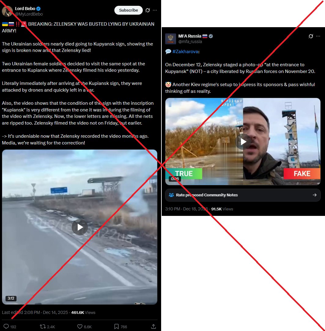
GeoConfirmed UKR - Misinformation by President Trump.
While we typically refrain from political commentary, President Donald Trump's recent statement regarding the war in Ukraine is so egregious that we feel compelled to respond.
Several claims made by President Trump have already been debunked. We've included responses from Grok AI for each claim, demonstrating that even Grok refutes the misinformation spread by the president.
In this thread, we will provide geolocated footage as a reminder to everyone that Russia invaded Ukraine on February 24, 2022, marking the beginning of this war.
1)
The United States has not spent $350 billion on this war, nor has it outspent Europe by $200 billion. In fact, European contributions have surpassed those of the US. Moreover, a significant portion of the American military aid (around 90% !) is spend in the US, reinvesting in the US economy.
statista.com/statistics/149…
eeas.europa.eu/delegations/un…
ifw-kiel.de/publications/n…
csis.org/analysis/where…
(Grok: x.com/i/grok/share/9…)
2)
President Zelensky did not claim that half the American money sent to Ukraine is "missing". He stated that half of the promised funds had not been received, which is a crucial distinction.
csis.org/analysis/where…
politifact.com/factchecks/202…
edition.cnn.com/2025/02/19/pol…
(Grok: x.com/i/grok/share/x…)
3)
Ukrainian constitution prohibits elections during wartime, a measure designed to protect the democratic process from foreign interference, particularly given Russia's known capabilities in this area...
foreignpolicy.com/2023/07/11/ukr…
edition.cnn.com/2024/03/30/eur…
united24media.com/war-in-ukraine…
(Grok: x.com/i/grok/share/i…)
4)
President Zelensky is not a dictator, as evidenced by Ukraine's constitutional framework and his commitment to holding elections once hostilities cease. In contrast, it's worth noting that President Putin consistently wins elections in Russia with implausibly high percentages of votes, with opposition that 'falls out of windows", is poisened or jailed, raising questions about the true nature of Russia's electoral process.
europarl.europa.eu/doceo/document…
oscepa.org/en/news-a-medi…
osce.usmission.gov/on-the-russian…
japantimes.co.jp/news/2024/03/1…
bbc.com/news/world-eur…
(Grok: x.com/i/grok/share/a…)
5)
President Zelensky has a approval rate above 50% and not 4%. 4% is Russian disinformation.
edition.cnn.com/2025/02/19/pol…
kiis.com.ua/?lang=eng&cat=…
euronews.com/2025/02/19/zel…
abcnews.go.com/International/…
(Grok: x.com/i/grok/share/I…)
6)
There was no NATO expansion to the East, as NATO itself cannot expand. Instead, democratic countries independently decide whether they want to become members of the alliance. The process of joining NATO is voluntary and involves multiple steps, including meeting specific requirements and completing a formal application process.
The fact that many of Russia's former neighbors have chosen to seek NATO membership speaks volumes about their perception of Russia and their desire for collective security.
The decision of these nations to pursue NATO membership reflects their sovereign right to determine their own foreign policy and security arrangements. It also indicates a preference for the stability and security guarantees that NATO membership offers, rather than remaining under Russian influence.
Regarding the famous 'promise':
Article 103 of the UN Charter establishes a clear hierarchy in international law. It states that obligations under the UN Charter prevail over obligations under any other international agreement in case of conflict. This supremacy extends beyond just treaties, as it is generally understood to also apply to customary international law.
The hierarchy can be summarized as follows:
1) UN Charter obligations
2) Other treaties and customary international law
3) Non-treaty international texts
4) Political promises or commitments
5) Historical claims
Russia's invasion of Ukraine clearly violates fundamental principles of the UN Charter, including the prohibition on the use of force against the territorial integrity of another state. Any attempts to justify this action based on lower-ranking considerations like political promises or historical claims are legally irrelevant.
euvsdisinfo.eu/report/there-i…
nato.int/cps/ra/natohq/…
iir.cz/lies-provocati…
(Grok: x.com/i/grok/share/f… and x.com/i/grok/share/N… and x.com/i/grok/share/N…)
8)
Who initiated this nearly three-year-long war? RUSSIA.
As a platform that has analyzed over 50,000 frames/videos related to the conflict, we will remind the president ,with geolocated footage, who started this war: RUSSIA.
Russia invaded Ukraine on February 24, 2022, despite repeatedly denying any plans for invasion in the preceding days.
x.com/Mike_Pence/sta…
edition.cnn.com/2025/02/19/pol…
(Grok: x.com/i/grok/share/m…)
---
24 FEB 2022 - Russian tanks crossing the border from Belarus into Ukraine in Senkivka.
52.106063, 31.780644
4Q4J+C7C Sen'kivka, Chernihiv Oblast, Ukraine
Sources: x.com/conflicts/stat…
1/11
24 FEB 2022 - Dozens of attack helikopters flying towards Antonov International Airport near Kiyv.
50.596695, 30.500903
HGW2+M9C Vyshhorod, Kyiv Oblast, Ukraine
GeoLocated by @AugustGraham
Geolocation: x.com/augustgraham/s…
Location: geoconfirmed.org/ukraine/0215e3…
Sources: x.com/ralee85/status…
2/11
50.596695, 30.500903
HGW2+M9C Vyshhorod, Kyiv Oblast, Ukraine
GeoLocated by @AugustGraham
Geolocation: x.com/augustgraham/s…
Location: geoconfirmed.org/ukraine/0215e3…
Sources: x.com/ralee85/status…
2/11
24 FEB 2022 - About 30 Russian helicopters engaged in attacking Antonov International Airport (Hostomel)
50.583768, 30.254727
H7M3+GV5 Hostomel', Kyiv Oblast, Ukraine
GeoLocated by @Cen4infoRes
Geolocation: x.com/cen4infores/st…
Location: geoconfirmed.org/ukraine/593743…
Sources: x.com/deanobeano1/st…
3/11
50.583768, 30.254727
H7M3+GV5 Hostomel', Kyiv Oblast, Ukraine
GeoLocated by @Cen4infoRes
Geolocation: x.com/cen4infores/st…
Location: geoconfirmed.org/ukraine/593743…
Sources: x.com/deanobeano1/st…
3/11
24 FEB 2022 - Fighting For Antonov International Airfield.
50.592508, 30.204879
H6V3+2X2 Hostomel', Kyiv Oblast, Ukraine
GeoLocated by @AugustGraham
Geolocation: x.com/AugustGraham/s…
Location: geoconfirmed.org/ukraine/23894e…
Sources: x.com/WhereisRussia/…
4/11
50.592508, 30.204879
H6V3+2X2 Hostomel', Kyiv Oblast, Ukraine
GeoLocated by @AugustGraham
Geolocation: x.com/AugustGraham/s…
Location: geoconfirmed.org/ukraine/23894e…
Sources: x.com/WhereisRussia/…
4/11

24 FEB 2022 - Russian armored columnn driving by on CCTV footage.
51.076524, 34.782413
3QGJ+JX3 Khotin', Sumy Oblast, Ukraine
GeoLocated by @EjShahid
Geolocation: x.com/EjShahid/statu…
Location: geoconfirmed.org/ukraine/368371…
Sources: x.com/Zn_Portnova/st…
5/11
51.076524, 34.782413
3QGJ+JX3 Khotin', Sumy Oblast, Ukraine
GeoLocated by @EjShahid
Geolocation: x.com/EjShahid/statu…
Location: geoconfirmed.org/ukraine/368371…
Sources: x.com/Zn_Portnova/st…
5/11
24 FEB 2022 - Street clashes between Ukraine & Russia in Ukrainian city of Okhtyrka.
50.30907, 34.878152
8V5H+J7C Okhtyrka, Sumy Oblast, Ukraine
GeoLocated by @Cen4infoRes
Geolocation: x.com/cen4infores/st…
Location: geoconfirmed.org/ukraine/19f1a9…
Sources: x.com/babaktaghvaee/…
6/11
50.30907, 34.878152
8V5H+J7C Okhtyrka, Sumy Oblast, Ukraine
GeoLocated by @Cen4infoRes
Geolocation: x.com/cen4infores/st…
Location: geoconfirmed.org/ukraine/19f1a9…
Sources: x.com/babaktaghvaee/…
6/11
24 FEB 2022 - Russian forces entering deeper in Ukraine from Crimea.
46.144877, 33.6337
4JVM+XF4 Preobrazhenka, Kherson Oblast, Ukraine
GeoLocated by @neonhandrail
Geolocation:
x.com/neonhandrail/s…
Location: geoconfirmed.org/ukraine/e4333c…
Sources: x.com/maxseddon/stat…
7/11
46.144877, 33.6337
4JVM+XF4 Preobrazhenka, Kherson Oblast, Ukraine
GeoLocated by @neonhandrail
Geolocation:
x.com/neonhandrail/s…
Location: geoconfirmed.org/ukraine/e4333c…
Sources: x.com/maxseddon/stat…
7/11
24 FEB 2022 - Russian armored column of 8 BMPs and 1 MTLB moving north towards Kherson.
46.48405, 32.979542
FXMH+JR7 Velyki Kopani, Kherson Oblast, Ukraine
GeoLocated by @neonhandrail
Geolocation: x.com/neonhandrail/s…
Location: geoconfirmed.org/ukraine/98e97f…
Sources: youtube.com/watch?v=2YwPgC…
8/11
46.48405, 32.979542
FXMH+JR7 Velyki Kopani, Kherson Oblast, Ukraine
GeoLocated by @neonhandrail
Geolocation: x.com/neonhandrail/s…
Location: geoconfirmed.org/ukraine/98e97f…
Sources: youtube.com/watch?v=2YwPgC…
8/11
24 FEB 2022 - Russian troops have crossed Antonovsky bridge over Dnieper river and moved into Antonivka suburb of Kherson city.
46.678419, 32.719509
MPH9+9R6 Antonivka, Kherson Oblast, Ukraine
GeoLocated by @Cen4infoRes
Geolocation: x.com/cen4infores/st…
Location: geoconfirmed.org/ukraine/9387a9…
Sources: x.com/aldin_ww/statu…
9/11
46.678419, 32.719509
MPH9+9R6 Antonivka, Kherson Oblast, Ukraine
GeoLocated by @Cen4infoRes
Geolocation: x.com/cen4infores/st…
Location: geoconfirmed.org/ukraine/9387a9…
Sources: x.com/aldin_ww/statu…
9/11
24-25 FEB 2022 - Supermarket CCTV cameras recording Russian vehicles and soldiers.
Russian troops move into Hostomel', set an ambush and attack 12 vehicles, which reportedly resulted in 11 civilian killed and 15 injured civilians.
Area around 50.555047, 30.274444
H74F+2Q8 Hostomel', Kyiv Oblast, Ukraine
GeoLocated by @Cosmonaut19
Geolocation: x.com/Cosmonaut19/st…
Location: geoconfirmed.org/ukraine/3cfea7…
Sources: Vid 1
t.me/pgo_gov_ua/6239
Vid 2 (part of Vid 1)
10/11
The above videos are only a fraction of our database.
Conclusion and reminder for President Trump:
On February 24, 2022, Russia launched a full-scale invasion of Ukraine, violating international law and the UN Charter. This action came despite repeated denials from Russian officials in the preceding days that they had any plans to attack Ukraine.
The invasion began with Russian President Vladimir Putin announcing a "special military operation" in eastern Ukraine, followed by missile strikes and ground incursions from multiple directions. This aggression constituted a clear breach of the UN Charter, specifically Article 2(4), which prohibits the use of force against the territorial integrity or political independence of any state.
Russia's actions were swiftly condemned by the international community. On March 2, 2022, the UN General Assembly adopted a resolution by an overwhelming majority (141 to 5) demanding that Russia immediately withdraw its forces from Ukraine. This resolution affirmed the international community's commitment to Ukraine's sovereignty, independence, and territorial integrity.
The invasion has resulted in the largest and deadliest conflict in Europe since World War II, causing hundreds of thousands of military casualties and tens of thousands of Ukrainian civilian casualties. It has also led to Europe's largest refugee crisis since World War II, with millions of Ukrainians displaced internally or forced to flee the country.
The invasion stands as a stark violation of international norms and treaties, undermining the post-World War II international order based on the UN Charter.
---
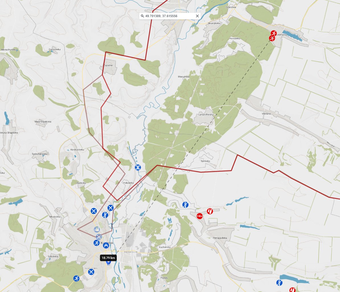
The picture below represents the footage our volunteers have analyzed: over 40.000 frames have been geolocated.
Each pin corresponds to a piece of footage that has been meticulously compared with geographical data to determine the exact location where the incident occurred. This process of geolocation involves matching visual elements from the footage with satellite imagery, street-level photography, and other geographical references to pinpoint the precise location of each event.
Our team has carefully verified each geolocation to ensure accuracy. This extensive database provides a comprehensive, evidence-based record of incidents related to the conflict, allowing for a detailed and factual understanding of events as they have unfolded on the ground.
More information (where you can check yourself):
geoconfirmed.org/ukraine
11/11
Conclusion and reminder for President Trump:
On February 24, 2022, Russia launched a full-scale invasion of Ukraine, violating international law and the UN Charter. This action came despite repeated denials from Russian officials in the preceding days that they had any plans to attack Ukraine.
The invasion began with Russian President Vladimir Putin announcing a "special military operation" in eastern Ukraine, followed by missile strikes and ground incursions from multiple directions. This aggression constituted a clear breach of the UN Charter, specifically Article 2(4), which prohibits the use of force against the territorial integrity or political independence of any state.
Russia's actions were swiftly condemned by the international community. On March 2, 2022, the UN General Assembly adopted a resolution by an overwhelming majority (141 to 5) demanding that Russia immediately withdraw its forces from Ukraine. This resolution affirmed the international community's commitment to Ukraine's sovereignty, independence, and territorial integrity.
The invasion has resulted in the largest and deadliest conflict in Europe since World War II, causing hundreds of thousands of military casualties and tens of thousands of Ukrainian civilian casualties. It has also led to Europe's largest refugee crisis since World War II, with millions of Ukrainians displaced internally or forced to flee the country.
The invasion stands as a stark violation of international norms and treaties, undermining the post-World War II international order based on the UN Charter.
---
The picture below represents the footage our volunteers have analyzed: over 40.000 frames have been geolocated.
Each pin corresponds to a piece of footage that has been meticulously compared with geographical data to determine the exact location where the incident occurred. This process of geolocation involves matching visual elements from the footage with satellite imagery, street-level photography, and other geographical references to pinpoint the precise location of each event.
Our team has carefully verified each geolocation to ensure accuracy. This extensive database provides a comprehensive, evidence-based record of incidents related to the conflict, allowing for a detailed and factual understanding of events as they have unfolded on the ground.
More information (where you can check yourself):
geoconfirmed.org/ukraine
11/11

• • •
Missing some Tweet in this thread? You can try to
force a refresh