Mashford Mahute Profile picture
Apr 25, 2025 1 tweets 1 min read Read on X
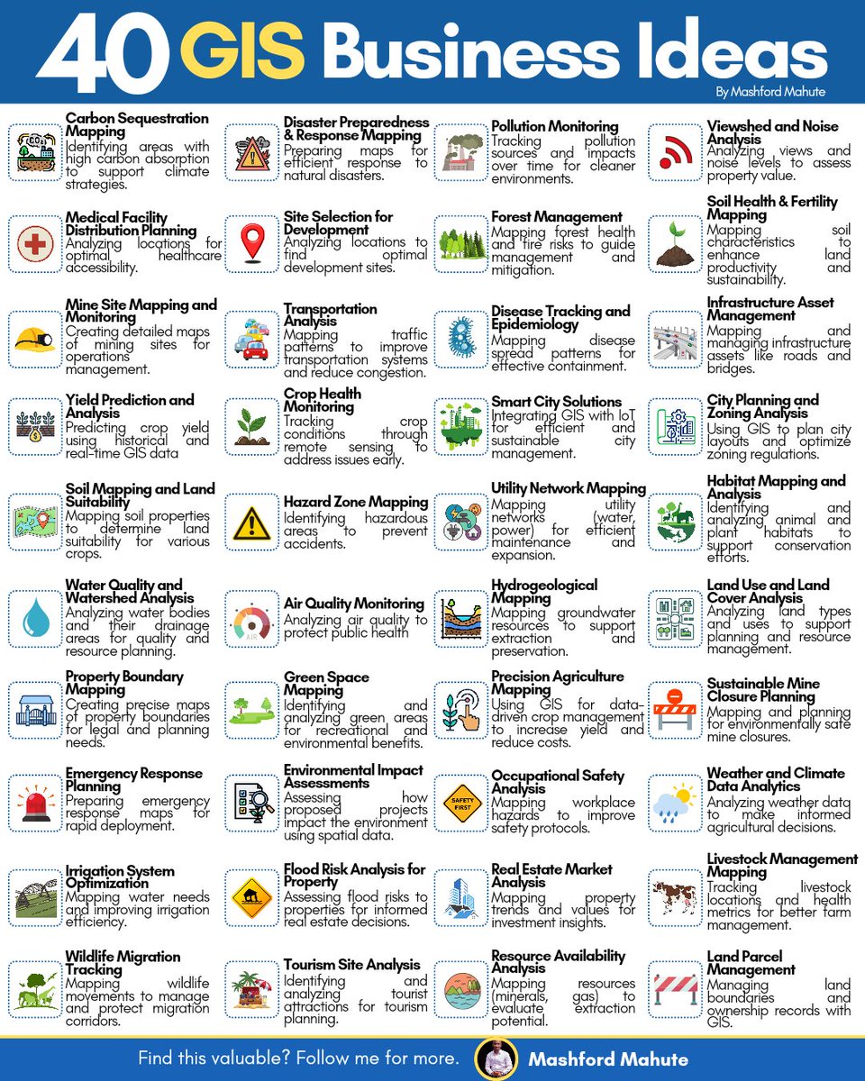
Looking to dive into the world of GIS entrepreneurship?

GIS offers a vast array of opportunities across multiple industries.

Explore these 40 GIS Business Ideas to inspire your next venture!

#GIS #QGIS #ArcGIS #Geospatial #RemoteSensing #Python #Entrepreneurship #Innovation Image

• • •

Missing some Tweet in this thread? You can try to force a refresh
 

Keep Current with Mashford Mahute

Mashford Mahute Profile picture

Stay in touch and get notified when new unrolls are available from this author!

Read all threads

This Thread may be Removed Anytime!

PDF

Twitter may remove this content at anytime! Save it as PDF for later use!

Try unrolling a thread yourself!

how to unroll video
  1. Follow @ThreadReaderApp to mention us!

  2. From a Twitter thread mention us with a keyword "unroll"
@threadreaderapp unroll

Practice here first or read more on our help page!

More from @MashfordMahute

Apr 19
21 FREE GOOGLE EARTH ENGINE PYTHON TUTORIALS

🪡🧵 Image
1. Python Flood Detection: youtube.com/watch?v=-2lzKD…

2. Python Vegetation Analysis: youtube.com/watch?v=kVI8Ap…

3. Python Precipitation Patterns: youtube.com/watch?v=UDxwtk…

4. Python Soil Moisture Drought: youtube.com/watch?v=OXZCRD…
5. Python Water Storage: youtube.com/watch?v=N-XvMk…

6. Python Wetland Detection: youtube.com/watch?v=TvvdUJ…

7. Python Lake Mapping: youtube.com/watch?v=LM5WCg…

8. Python Evapotranspiration Modelling: youtube.com/watch?v=vVgFm_…

9. Python Trend Monitoring: youtube.com/watch?v=tHHv_O…
Read 6 tweets
Mar 17
12 FREE GOOGLE EARTH ENGINE TUTORIALS FOR AGRICULTURE

🪡🧵 Image
1. Phenological Cycle: youtube.com/watch?v=kVI8Ap…

2. Growing Season Length: youtube.com/watch?v=mUXWhh…

3. Crop Irrigation Index: youtube.com/watch?v=OAKstK…

4. Crop Type using SAR: youtube.com/watch?v=1dC6Q0…

5. Crop Type using Sentinel: youtube.com/watch?v=am-5y0…
6. Crop Moisture: youtube.com/watch?v=DbwApp…

7. Crop Water Stress Index: youtube.com/watch?v=34UUMl…

8. Cropland Area: youtube.com/watch?v=lP-7YU…

9. Leaf Area Index: youtube.com/watch?v=5Vtxnl…

10. Soil Moisture using Landsat: youtube.com/watch?v=9y5iDf…
Read 4 tweets
Mar 14
𝗛𝗼𝘄 𝗜 𝗖𝗿𝗲𝗮𝘁𝗲𝗱 𝗧𝗵𝗶𝘀 𝗟𝗮𝗻𝗱 𝗖𝗼𝘃𝗲𝗿 𝗠𝗮𝗽 (𝗦𝘁𝗲𝗽-𝗯𝘆-𝗦𝘁𝗲𝗽 𝗶𝗻 𝗤𝗚𝗜𝗦)

Here is the workflow to produce this 𝗟𝗮𝗻𝗱 𝗖𝗼𝘃𝗲𝗿 𝗠𝗮𝗽 𝗼𝗳 𝗕𝗲𝗻𝗶𝗻 using 𝗘𝗦𝗥𝗜 𝗦𝗲𝗻𝘁𝗶𝗻𝗲𝗹‐𝟮 𝟭𝟬𝗺 𝗟𝗮𝗻𝗱 𝗖𝗼𝘃𝗲𝗿 & elevation data from 𝗨𝗦𝗚𝗦.

🪡🧵 Image
𝟭. 𝗗𝗼𝘄𝗻𝗹𝗼𝗮𝗱 𝘁𝗵𝗲 𝗗𝗮𝘁𝗮

𝗟𝗮𝗻𝗱 𝗖𝗼𝘃𝗲𝗿 𝗗𝗮𝘁𝗮

Download the 𝟮𝟬𝟮𝟰 𝗘𝗦𝗥𝗜 𝗦𝗲𝗻𝘁𝗶𝗻𝗲𝗹-𝟮 𝟭𝟬𝗺 𝗟𝗮𝗻𝗱 𝗖𝗼𝘃𝗲𝗿 𝗱𝗮𝘁𝗮𝘀𝗲𝘁 from:

ArcGIS Living Atlas:

𝗘𝗹𝗲𝘃𝗮𝘁𝗶𝗼𝗻 𝗗𝗮𝘁𝗮: 👇livingatlas.arcgis.com/landcoverexplo…
Download 𝗦𝗥𝗧𝗠 𝗗𝗘𝗠 𝘁𝗶𝗹𝗲𝘀 from:

USGS Earth Explorer:

𝟮. 𝗠𝗼𝘀𝗮𝗶𝗰 𝘁𝗵𝗲 𝗟𝗮𝗻𝗱 𝗖𝗼𝘃𝗲𝗿 𝗧𝗶𝗹𝗲𝘀

In 𝗤𝗚𝗜𝗦:

𝗥𝗮𝘀𝘁𝗲𝗿 → 𝗠𝗶𝘀𝗰𝗲𝗹𝗹𝗮𝗻𝗲𝗼𝘂𝘀 → 𝗕𝘂𝗶𝗹𝗱 𝗩𝗶𝗿𝘁𝘂𝗮𝗹 𝗥𝗮𝘀𝘁𝗲𝗿

Settings:earthexplorer.usgs.gov
Read 17 tweets
Jul 30, 2025
1. Spatial Resolutions: ASTER, Landsat, Sentinel & UAVs

In EO, spatial resolution determines the size of the smallest object that can be detected by a sensor. Choosing the right dataset often depends on the balance between resolution, cost & coverage. Here's a quick comparison: Image
2. ASTER (Advanced Spaceborne Thermal Emission and Reflection Radiometer)

➡️ VNIR: 15 m
➡️ SWIR: 30 m
➡️ TIR: 90 m

Landsat (e.g., Landsat 8/9)

➡️ Multispectral: 30 m
➡️ Panchromatic: 15 m
➡️ Thermal: 100 m (resampled to 30 m)
3. Sentinel-2
➡️ Multispectral: 10 m, 20 m, 60 m (depending on the band)

UAVs (Drones)

➡️ Extremely high resolution: \~2–20 cm, depending on flight altitude and sensor.
Read 6 tweets
May 11, 2025
13 FREE GOOGLE EARTH ENGINE TUTORIALS FOR BEGINNERS

🪡🧵 Image
1. Get Started with GEE: youtube.com/watch?si=cgwzk…

2. Introduction to Code Editor: youtube.com/watch?v=8rTZS3…

3. Basic JavaScript Data Types: youtube.com/watch?v=W6u1rB…

4. JavaScript Data Types: youtube.com/watch?v=Nd0Ne7…

5. Client Side versus Server Side: youtube.com/watch?v=hsL3hb…
6. Remote Sensing Workflows: youtube.com/watch?v=h2PiOG…

7. Image Visualization: youtube.com/watch?v=xIM4V6…

8. Working with Image Collection: youtube.com/watch?v=U_6SCY…

9. Filtering Image Collection: youtube.com/watch?v=5hGnPy…

10. Feature Collection: youtube.com/watch?v=Ss5dYg…
Read 5 tweets
Apr 25, 2025
18 FREE GEOAI TUTORIALS

🪡🧵 Image
1. Introducing the GeoAI Python Package: youtube.com/watch?v=teqyY8…

2. Downloading NAIP Imagery and Building Footprint Data for Deep Learning: youtube.com/watch?v=5qfZe_…

3. Viewing Metadata and Raster Clipping: youtube.com/watch?v=GohxJQ…
4. Creating Georeferenced Image Chips for Deep Learning: youtube.com/watch?v=9kuAVY…

5. Building Footprint Extraction Using Deep Learning and GeoAI: youtube.com/watch?v=inmWF_…

6. Building Footprint Regularization Using Deep Learning and GeoAI: youtube.com/watch?v=I8p2fQ…
Read 9 tweets

Did Thread Reader help you today?

Support us! We are indie developers!


This site is made by just two indie developers on a laptop doing marketing, support and development! Read more about the story.

Become a Premium Member ($3/month or $30/year) and get exclusive features!

Become Premium

Don't want to be a Premium member but still want to support us?

Make a small donation by buying us coffee ($5) or help with server cost ($10)

Donate via Paypal

Or Donate anonymously using crypto!

Ethereum

0xfe58350B80634f60Fa6Dc149a72b4DFbc17D341E copy

Bitcoin

3ATGMxNzCUFzxpMCHL5sWSt4DVtS8UqXpi copy

Thank you for your support!

Follow Us!

:(