Way up North, #Russia 🇷🇺 opened a new front at #Sumy, hoping to get close enough to the city to control its supply routes and shell it, but #Ukraine 🇺🇦 is opposing fierce resistance, aided by the strong brigades and natural obstacles.
🧵Thread 🧵1/⬇️
🧵Thread 🧵1/⬇️

2/🧵
After the capture of Sverdlikovo and Nikolayevo-Daryino, Kursk Oblast', already in early February 2025, Russian forces started attacking southwards across the state border towards Novenke and in the fields between Zhuravka and Basivka.
After some small initial successes, they got rapidly bogged down because of Ukrainian drone crews that were freely hunting them in the open fields and the number of capable brigades that had just retreated from the Kursk salient and regrouped around that area.

3/🧵
Seeing that they were effectively stuck, the Russians decided to do what they can do best: lengthen the front, exploiting their superior resources, and threatening with encirclement the Ukrainian forces opposing them at the original frontline.
Facing what was described as a horde of Russian infantry along this frontline, the Ukrainians had to retreat further back.
Though, this retreat was not properly conducted or orderly, and the Russians were able to exploit more than a gap to advance further than the Ukrainians expected.

4/🧵
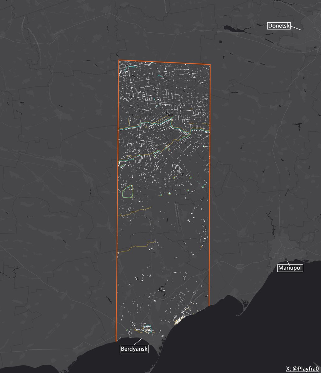
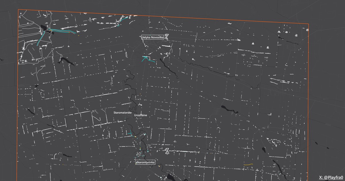
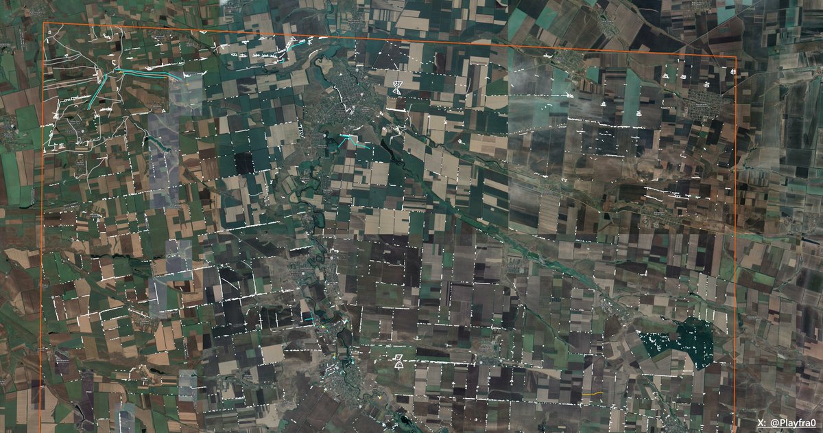
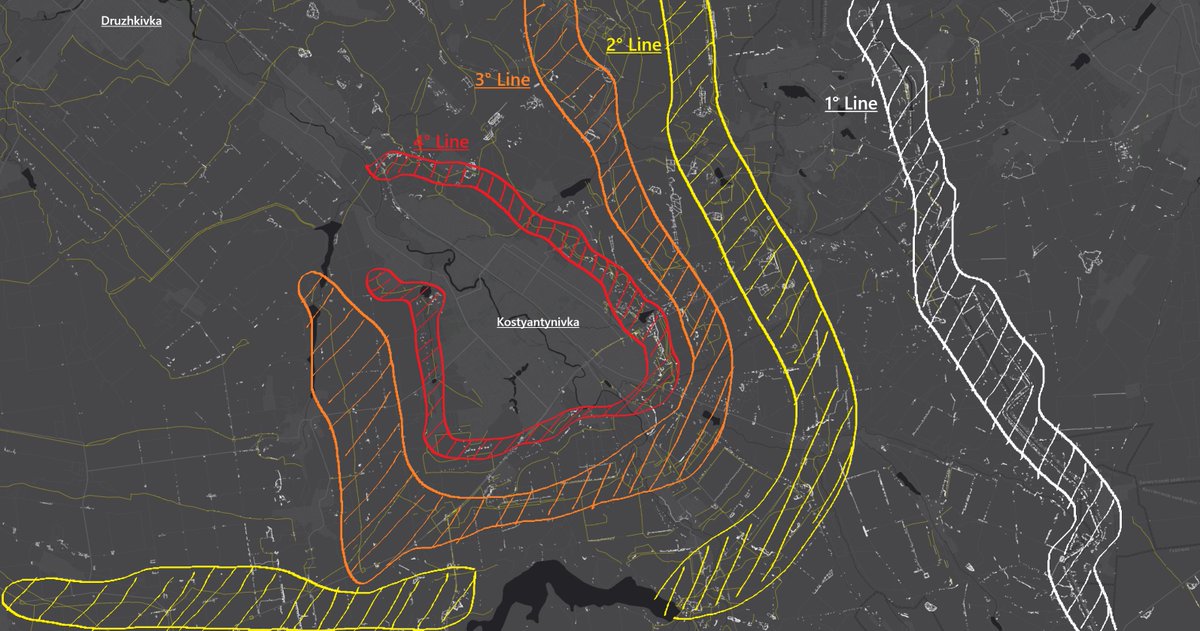
This leads us to today, where the Russians strongly consolidated their presence in Sumy Oblast' along the Kindrativka - Oleksiivka - Bilovody - Basivka line (photo #1), which to them constitutes a great springboard for further offensive operations, which they're trying to expand southwards.
To even get close to the city, though, they first need to break through and capture the strong Yastrubyne - Khotin - Yunakivka line (photo #2).
These 3 names of settlements identify the largest settlements at the halfway point between the border and Sumy, which makes them perfect staging and accumulation points for both sides.
Between these settlements, moreover, lies a very big forested area, which the Russians will use to further accumulate their personnel and vehicles, with the added bonus of solid camouflage.
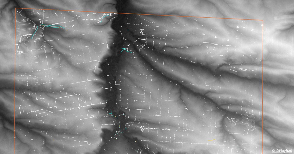
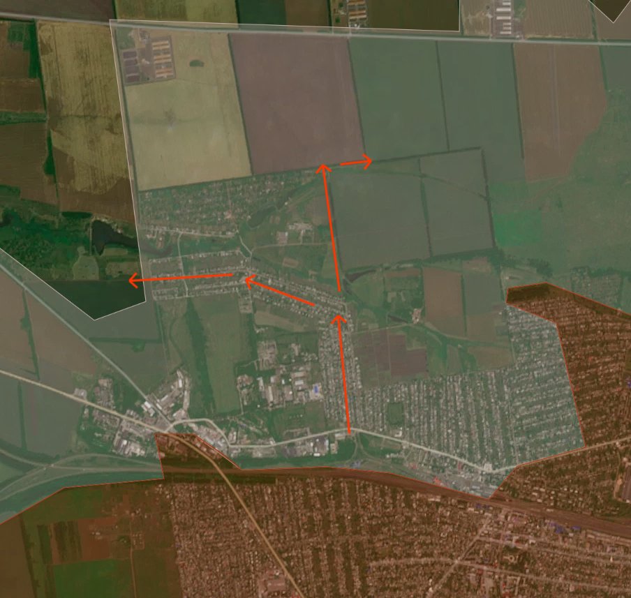
Furthermore, the whole line is located on top of a dominant hill ridge (photo #3), that would give Russian UAV operators free entry into Sumy and severely endanger its supply routes.
This leads us to today, where the Russians strongly consolidated their presence in Sumy Oblast' along the Kindrativka - Oleksiivka - Bilovody - Basivka line (photo #1), which to them constitutes a great springboard for further offensive operations, which they're trying to expand southwards.
To even get close to the city, though, they first need to break through and capture the strong Yastrubyne - Khotin - Yunakivka line (photo #2).
These 3 names of settlements identify the largest settlements at the halfway point between the border and Sumy, which makes them perfect staging and accumulation points for both sides.
Between these settlements, moreover, lies a very big forested area, which the Russians will use to further accumulate their personnel and vehicles, with the added bonus of solid camouflage.
Furthermore, the whole line is located on top of a dominant hill ridge (photo #3), that would give Russian UAV operators free entry into Sumy and severely endanger its supply routes.


5/🧵
Contrary to popular belief, Sumy is defended by outdated fortifications.
Until some months ago, we could've said that this region had one of the best defensive lines to protect it of all Ukraine, together with Zaporizhzhia. But in such a little time span, the rules of this war were turned upside-down by various upgrades to drones by the Russian side especially.
This is to testify that this is a war of innovation, together with the other things.
Going back to the fortifications, here are some examples.
They might look like very big, imposing, and powerful trench systems near roads and important objectives, but the truth is that most of the times the soldiers won't even bother to occupy them, and will rather take up positions in the treelines near them, which are multiple times more valuable because of camouflage.
Why is camouflage important? Because this war is a war of drones. You can have the most reinforced dugout in that trench system, but Russian operators can very simlpy throw at it 10 FPVs, and you will have to retreat... but where? In another dugout in the middle of the field that will be immediately targeted again?
The pictures represent trench systems around the Sumy city defensive line.


6/🧵
Obviously, Ukraine is not at fault for having built these trench systems, because they were constructed in 2023 when drones weren't playing as big of a part in this war as now.
What they are at fault for, though, is not fixing this problem and not starting to build the so-called "guts" inside treelines.
In photo #1 you can see a great example of a "gut". In particular, this one was built by Russians to counter Ukraine's 2023 summer offensive near Verbove (47.4796134, 35.9329742).
As you can see, the trench system was mostly covered (now only a few parts still have covered ways), it was camouflaged in between trees and foliage, rendering Ukrainian reconnaissance virtually impossible in the summer months without literally deleting the treeline.
This "habit" has been mostly lost by Ukrainian engineering forces in the rear, that receive orders to build trenches in the open, while it remains in only some of the most static areas of the frontline. I'm not a big fan even of the style in photo #2, even though it's better, having a camouflaged dugout and (still unfinished) covered ways.
If it's not possible to dig "guts" for whatever reason, photo #3 is the best option in my opinion. Small, independent systems with a dugout and (in this case unfinished, too) covered ways. Everything, crucially, inside the treeline.
Ukrainian engineers, though, must use small excavators that do not uproot trees, and rather dig between them, so that the situation in photo #3 does not happen. This also has the added benefit of being able to dig closer to the frontline, as the excavator can move while camouflaged inside treelines.
Source video for pictures #2 and #3: t.me/batalion2Z/127


7/🧵
Getting back to our strategical analysis, here are the exact steps I would take to stabilize this direction if I were in the Ukrainian higher command:
1. Start digging trench systems in the massive forested areas northeast of Sumy, both at the massif's edge, looking at the fields (photo #1), and in the deeper areas of the forest, and immediately place drone operators there, that will also prepare their smaller positions and enlarge them expecting a retreat of the infantry in front of them. This forest massif has a great chance of becoming a "swamp" for Russian forces just like Kreminna: the experienced units are there.
Furthermore, it has hard slopes, very dense greenery, is periodically cut by small clearings (photo #2) and even has lakes deep inside the massif (photo #3). All of these things together have the potential of turning this area into a living hell for Russian forces.
2. Prepare very solid plans to retreat to the Yastrubyne - Khotin - Yunakivka line. Further disorganized retreats cannot be allowed and Ukraine can't afford to let the Russians into such strategical positions. If necessary, blow the bridges over the Oleshnya river (the river passing through most of the line's towns). Plan kill zones that the Ukrainian UAV operators stationed in the forest massif will be able to easily control.
3. Reinforce the Pysarivka - Yastrubyne line, rather than the Pysarivka - Yunakivka one. The first is much easier to break through than the second, which as said presents very hard terrain.
4. Buy time for the Richky - Mykolaivka - Stetskivka line to be reinforced, but don't think twice about withdrawing from positions if needed. Stubbornly holding your positions over a certain limit is the worst mistake in the situation Ukraine is in, especially about manpower.


8/🧵
Obviously, these steps are easier said than done to finish in practice. This will take time and effort, both of which Ukraine is limited in. Furthermore, I designed them not knowing what the Ukrainian command knows. The situation might be different than what we imagine it to be.
Pretty obvious specifications in my opinion, but just being safe.
9/🧵
Personally, I do not think that the Sumy front is inherently dangerous. I strongly think Sumy city will NOT be captured by Russian forces in this war, first of all because it's not their objective, and secondly because of its characteristics. The city is big. Not Bakhmut, Pokrovsk or Chasiv Yar big. We're talking about 145 km², which is 2.5x Toretsk, 5x Pokrovsk and 6x Myrnohrad.
It looks like the city itself, too, was built for defensive purposes: absolutely massive high-rise and industrial areas, split in multiple parts by rivers, the whole eastern side defended by the same massive forest massif, and the flanks secured by sizeable cities behind rivers.
Even if the Yastrubyne - Khotin - Yunakivka line were to be abandoned, the Russians would encounter a topographical and orographic nightmare before reaching the city.
10/🧵
In conclusion, the Russians do NOT want and can NOT capture the city. For them, capturing the Khotin heights is more than enough, because from there they will have a stable foothold into the Oblast', but most importantly they will be able to shell and strike with UAVs Sumy city itself, rendering it dead, just like Pokrovsk, Myrnohrad and many, many others. This is the only thing to be worried about. The city falling is not even remotely a possibility.
In conclusion, the Russians do NOT want and can NOT capture the city. For them, capturing the Khotin heights is more than enough, because from there they will have a stable foothold into the Oblast', but most importantly they will be able to shell and strike with UAVs Sumy city itself, rendering it dead, just like Pokrovsk, Myrnohrad and many, many others. This is the only thing to be worried about. The city falling is not even remotely a possibility.
11/🧵
Thanks for reading this thread!
A ton of work goes into every single picture and paragraph, so if you liked this thread and learned something new from it, I would really appreciate a repost and a follow to support me and help me reach a larger audience.
Don't forget to join my Telegram channel here! t.me/PlayfraOSINT
• • •
Missing some Tweet in this thread? You can try to
force a refresh