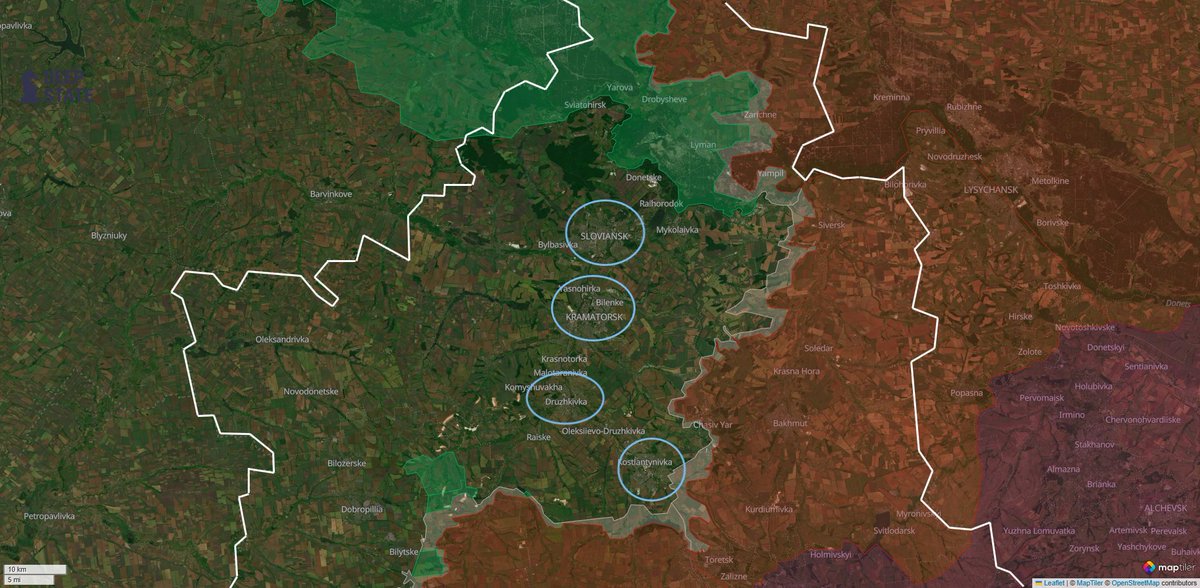
🚩The Zaporizhzhia defensive device and the Surovikin line: #Russia 🇷🇺's 2023 engineering masterpiece.
An in-depth analysis on the Tokmak slice project, the defensive line's characteristics and what we can learn from it today.
🔎View it here:
🧵Thread🧵 1/⬇️google.com/maps/d/u/0/vie…
An in-depth analysis on the Tokmak slice project, the defensive line's characteristics and what we can learn from it today.
🔎View it here:
🧵Thread🧵 1/⬇️google.com/maps/d/u/0/vie…

2/🧵
In 2022, after failing to quickly capitulate Ukraine, the Russians completely withdrew their forces from the north of the country, concentrating everything on the east.
In September of the same year, though, the Ukrainians found a weak spot in Russia's groupment of forces in the Kharkiv Oblast', and decided to strike with great force, collapsing the front for 100km in the famous Kharkiv counteroffensive.
After this incredible victory, the Ukrainians started planning and accumulating resources to attempt a further counteroffensive, this time in multiple sectors of the frontline.
As such, Russia almost completely switched to a defensive posture, only limiting their offensives to a couple of their most promising directions, as for example Bakhmut.


3/🧵
The Surovikin line takes its name from Russian general Sergey Surovikin, that had this line built immediately after the already discussed Ukrainian Kharkiv counteroffensive.
The Surovikin line is the most extensive set of fortifications built since the end of WW2, and it stretches for a colossal 2000km from Belarus to the Dnipro river's delta. Since September 2022, construction continued at full speed until early 2024, only then slowing down because of their renewed offensives and switch of focus from defensive to offensive. But even since then, construction has always been ongoing, with the Russians very slowly extending their fortifications and reinforcing currently existing ones.


4/🧵
Because of the sheer number of total fortifications built, it has not been possible for anyone as of now to map the Surovikin Line in full resolution, as such excluding a very big number of smaller trench systems, that, contrary to popular belief, were the one of the main reasons of the failure of Ukraine's 2023 counteroffensive. Furthermore, the maps that are currently used the most online have been made using old satellite imagery, and are missing an enormous amount of newly built fortifications and upgrades to older ones.
This is why I decided to take the most famous slice of Ukraine at the times of the 2023 counteroffensive, the Tokmak slice (which includes Robotyne and Verbove, and goes from Orikhiv all the way to the Azov Sea), and to map it in full resolution.
In this dataset, every single foxhole is mapped. Every single dragon's tooth, every single anti-tank ditch, from the smallest to the biggest. Every artillery emplacement, every hidden trench system under the trees, every road barricade. The smallest features do not exceed a meter in length.
The total dimension of the dataset is 31,000 features (1/6 of what I had mapped for all of Ukraine), or 4MB of pure, compressed trenches.
Used satellites: ESRI, Planet; in the picture @projectowlosint's map
Let's dive in.
5/🧵
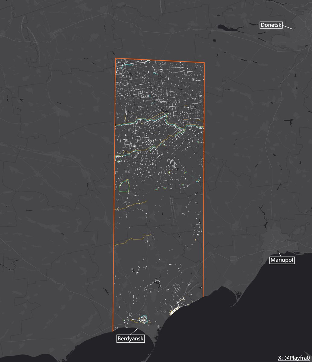
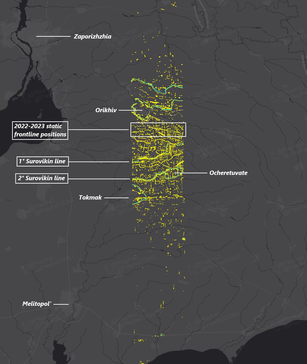
Here is my work in full, revealing the full structure of this section of the Surovikin Line.
You can clearly see the slice I was talking about. 3 rings are visible: at 1/3 (north to south) on the left you can see the Orikhiv defensive ring, at 1/2 on the right is the Ocheretuvate node, and just southwest of it is Tokmak, which also has its own defensive ring.
The "ring" trend is particularly common in Russia's defensive works, as most of the biggest cities are usually surrounded by an independent fortification line.
In the picture below you can easily distinguish these fortifications.
🔎Interactive map: google.com/maps/d/u/0/vie…
6/🧵
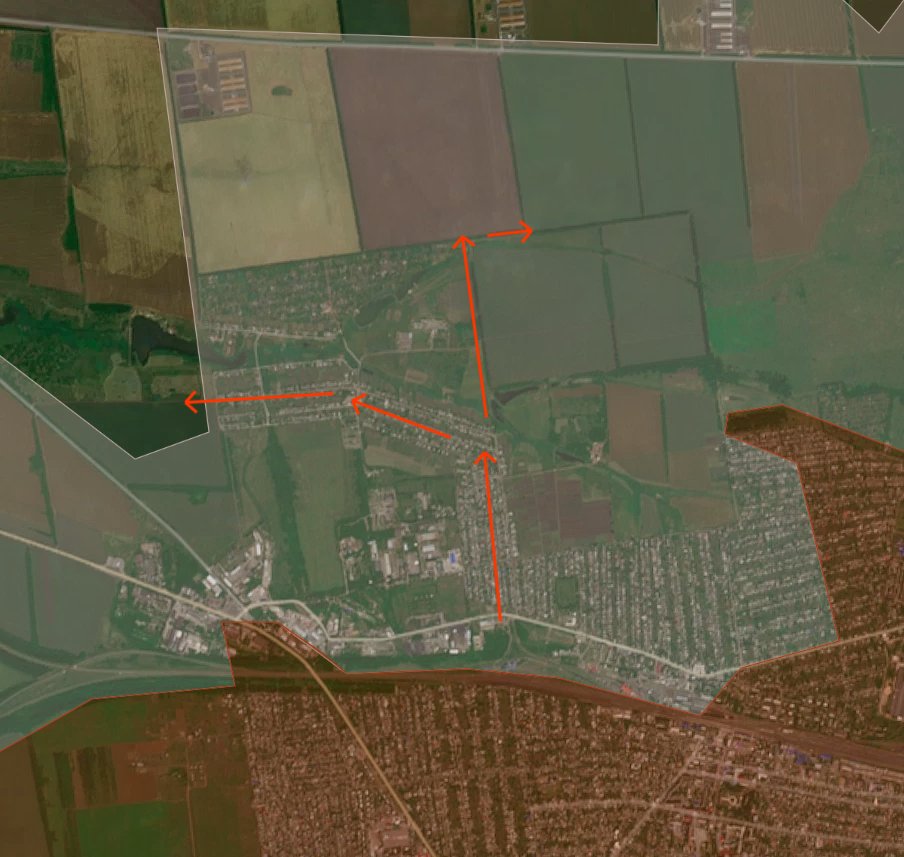
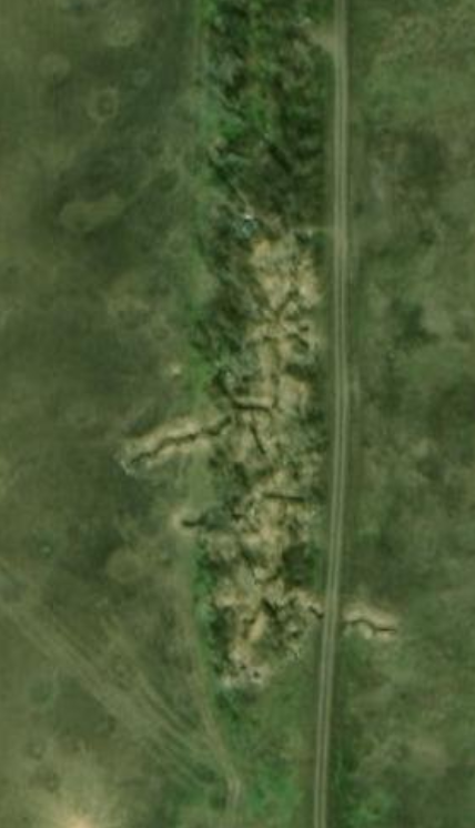
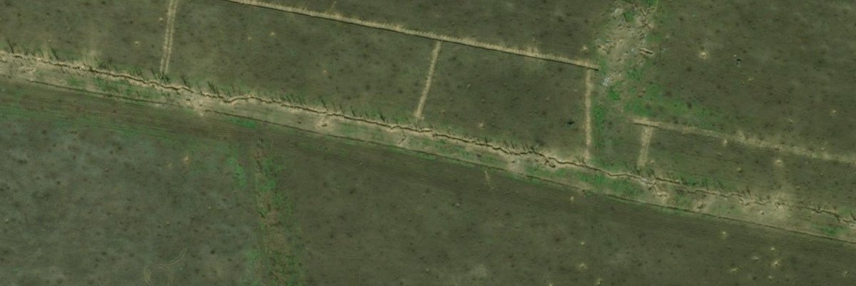
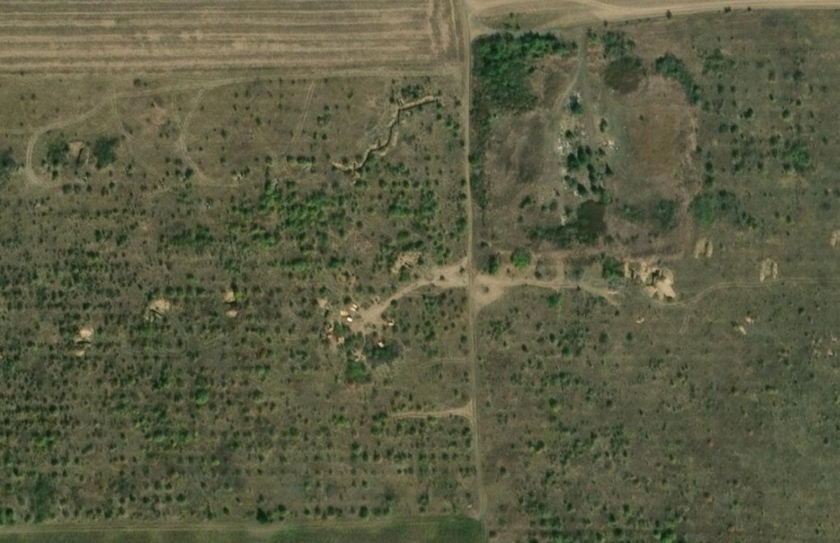
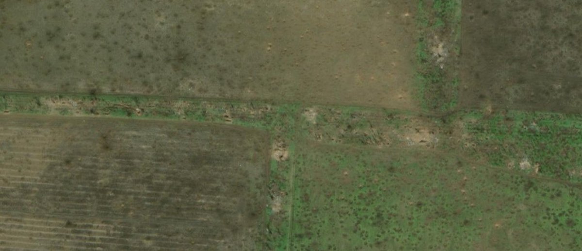
Starting from the north, let's analyze the 2022-2023 static frontline positions.
After the start of the full-scale invasion, the Russians quickly captured most of Zaporizhzhia Oblast's fields, and the Ukrainians were only able to stop them at the Kamyanske - Vuhledar line. This sector is one of the parts of this front line that remained dormant until the Ukrainian 2023 counteroffensive.
In this sector, the contact line froze at the H-08 Orikhiv-Kam'yanka highway, and gave much time to both sides to manually dig in and significantly upgrade their trench systems.
In the picture is an example of these positions: small foxholes between trees evolved into very complex trench systems in the course of the months, constantly reinforced by both sides until the start of the counteroffensive. Obviously, both sides dug fallback trench systems and positions, which makes this "zone" somewhat deeper than the contact line's width.
7/🧵
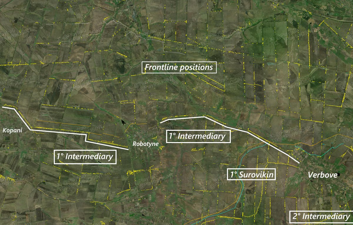
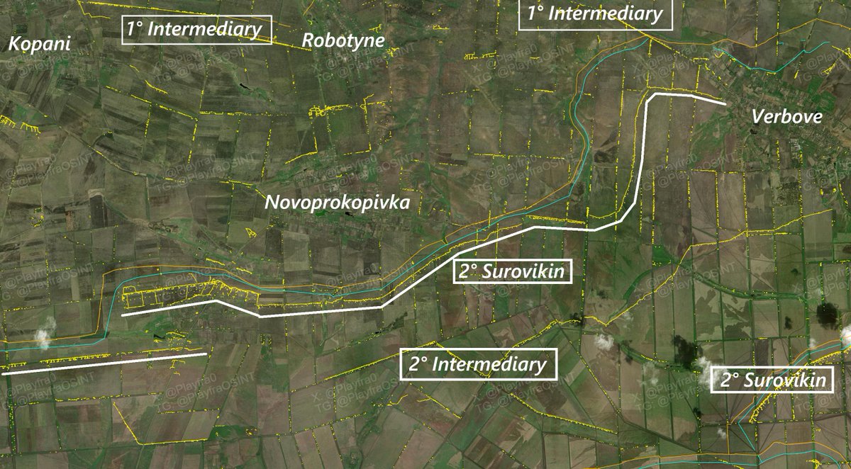
Deeper we go, onto the next zone.
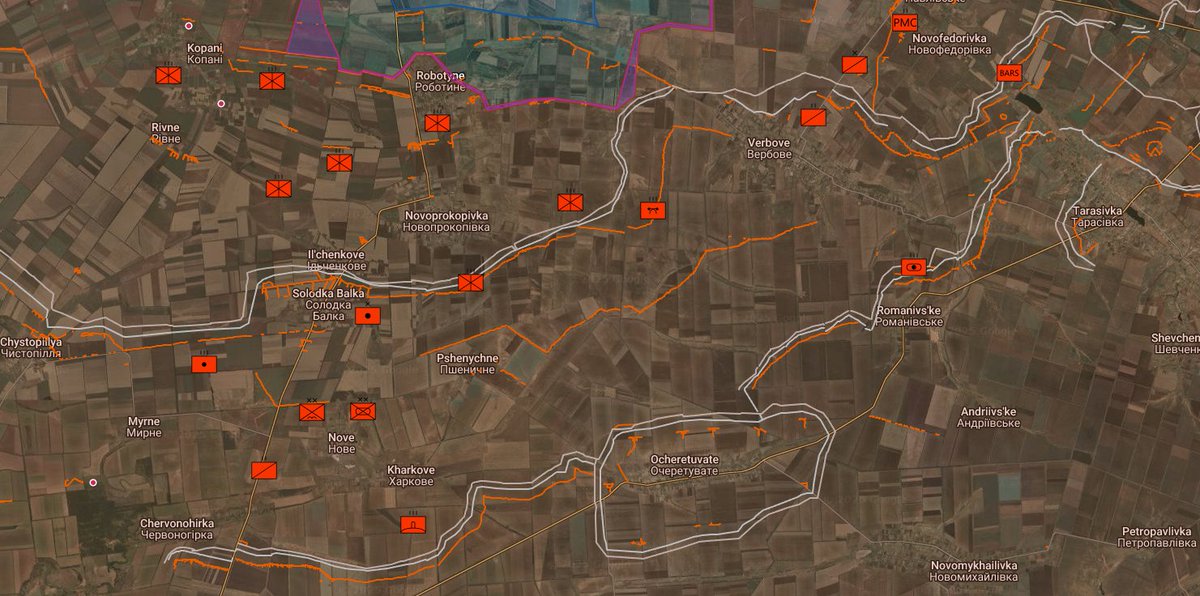
The next we find is what I call the "1° Intermediary line". I call it this because it is situated between the frontline fallback positions and the 1° Surovikin line, and because it is not a full-fledged line, as it was too close to the frontline to bring in heavy equipment to dig better trench systems, anti-tank ditches and place dragon's teeth.
The line, in this sector, counts on 3 pins: Kopani, Robotyne and Verbove.
This line has almost the same characteristics of the frontline positions, but with the added bonus of being better reinforced, as the engineers that dug these would've had to worry much less about enemy fire and surveillance. It is as such said that Robotyne was linked to the forests just east with a tunnel, that is the same one that significantly complicated Russian attacks after the counteroffensive's steam ended. But this has never been confirmed.
This line was meant to be the first actual significant obstacle for the Ukrainian counteroffensive, and to absorb its first punch. It was not meant to hold, but to slightly slow down the Ukrainians in preparation for the withdrawal to the 1° Surovikin line.
Deeper we go, onto the next zone.
The next we find is what I call the "1° Intermediary line". I call it this because it is situated between the frontline fallback positions and the 1° Surovikin line, and because it is not a full-fledged line, as it was too close to the frontline to bring in heavy equipment to dig better trench systems, anti-tank ditches and place dragon's teeth.
The line, in this sector, counts on 3 pins: Kopani, Robotyne and Verbove.
This line has almost the same characteristics of the frontline positions, but with the added bonus of being better reinforced, as the engineers that dug these would've had to worry much less about enemy fire and surveillance. It is as such said that Robotyne was linked to the forests just east with a tunnel, that is the same one that significantly complicated Russian attacks after the counteroffensive's steam ended. But this has never been confirmed.
This line was meant to be the first actual significant obstacle for the Ukrainian counteroffensive, and to absorb its first punch. It was not meant to hold, but to slightly slow down the Ukrainians in preparation for the withdrawal to the 1° Surovikin line.
8/🧵
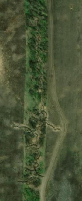
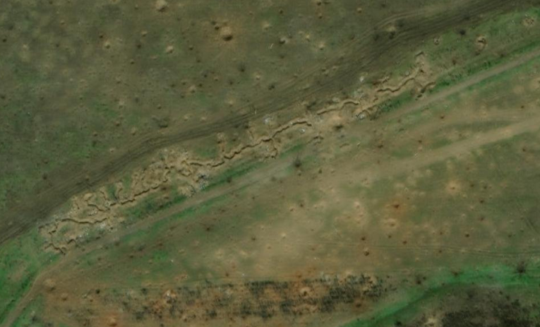
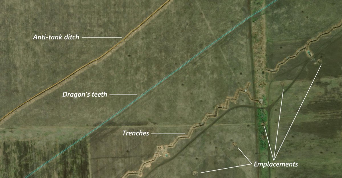
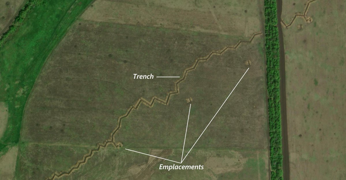
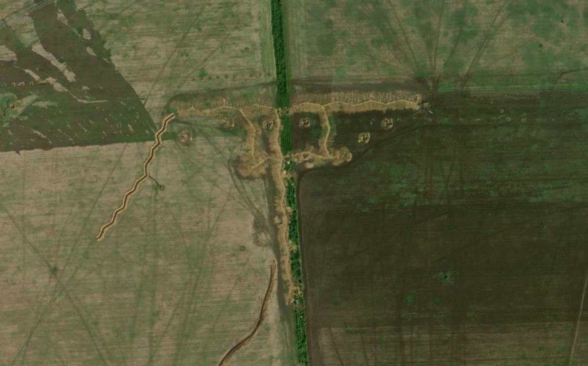
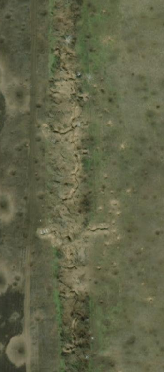
At this depth the fun finally starts: we encounter the 1° Surovikin line.
As you can see, the depth is sufficient enough to bring heavy machinery to work and to make more serious engineering works. Most of the line is made up of an anti-tank ditch, a dragon's teeth line and trench systems with dugouts at regular intervals. Behind the trenches are artillery/vehicle emplacements, also at regular intervals.
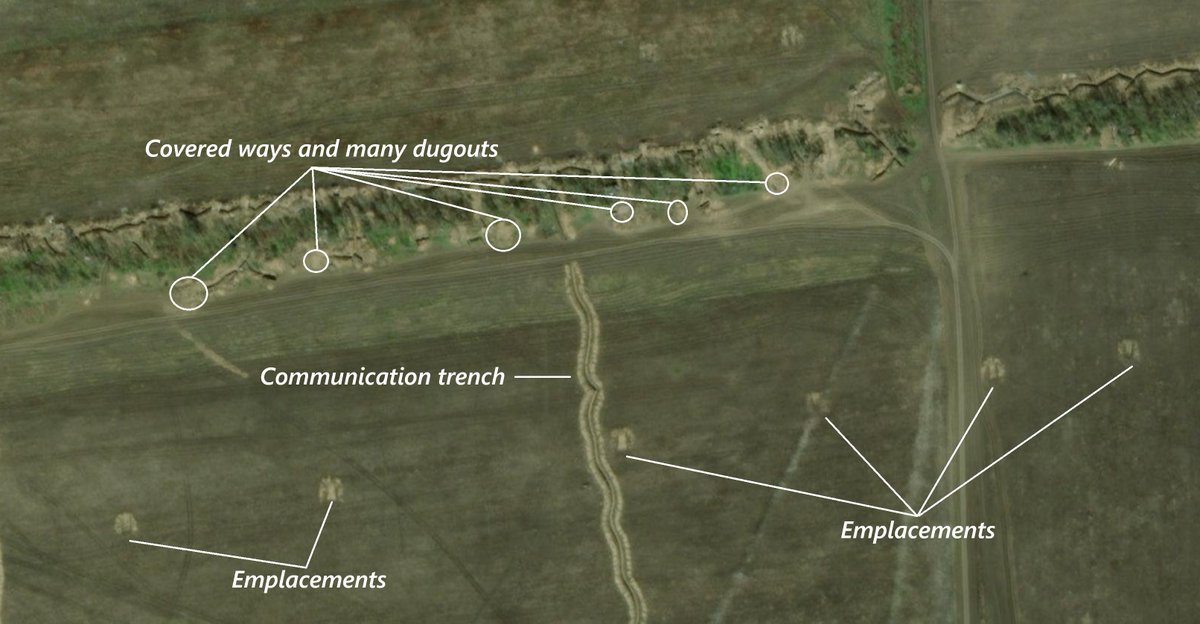
In the sections of the line when it is parallel to a treeline, it gets much more complex because of the given camouflage opportunities, and it gets even more reinforced and solid, with many covered parts and dugouts hidden in the trees. In some cases, communication trenches, too.
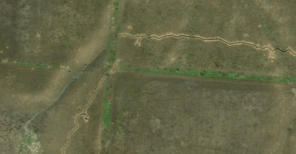
In some parts, though, the line can thin out, literally and in terms of complexity, with only a simple trench system with periodical dugouts being present. This is the case of the Novoprokopivka - Verbove section, which might be one of the reasons of why Ukraine chose to attack here.
This line was meant to be the one that "tanked" the first hit and slowed down the Ukrainian train, because as we know the Surovikin system is a layered one.
At this depth the fun finally starts: we encounter the 1° Surovikin line.
As you can see, the depth is sufficient enough to bring heavy machinery to work and to make more serious engineering works. Most of the line is made up of an anti-tank ditch, a dragon's teeth line and trench systems with dugouts at regular intervals. Behind the trenches are artillery/vehicle emplacements, also at regular intervals.
In the sections of the line when it is parallel to a treeline, it gets much more complex because of the given camouflage opportunities, and it gets even more reinforced and solid, with many covered parts and dugouts hidden in the trees. In some cases, communication trenches, too.
In some parts, though, the line can thin out, literally and in terms of complexity, with only a simple trench system with periodical dugouts being present. This is the case of the Novoprokopivka - Verbove section, which might be one of the reasons of why Ukraine chose to attack here.
This line was meant to be the one that "tanked" the first hit and slowed down the Ukrainian train, because as we know the Surovikin system is a layered one.
9/🧵
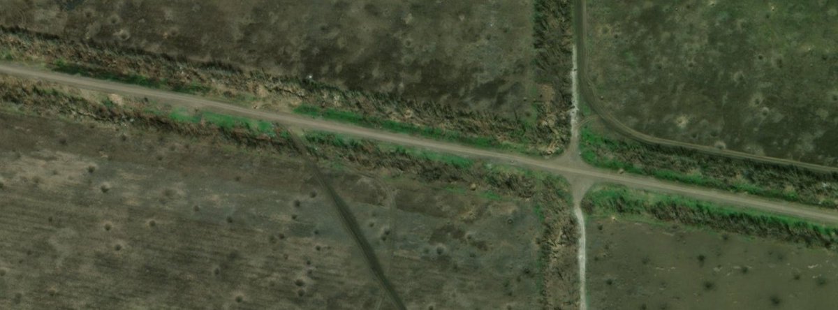
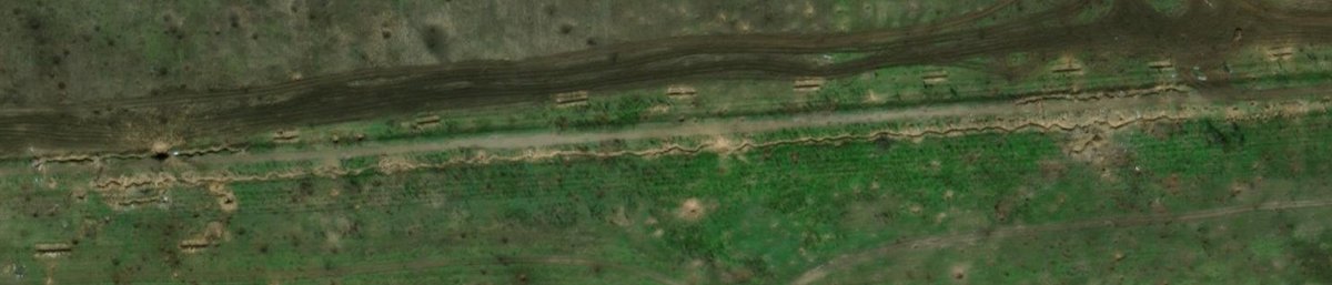
Immediately after the 1° Surovikin line, we encounter the 2° Intermediary. This line was meant to not give Ukrainians breathing and maneuvering room after they captured the 1° Surovikin line and to prepare, again, for another Ukrainian punch to the 2° Surovikin line further south.
Just like the 1° Intermediary line, there's not that much to say. The line is composed of a simple trench with some emplacements behind. This time even dugouts are not present, only appearing when this line is parallel with nearby treelines.
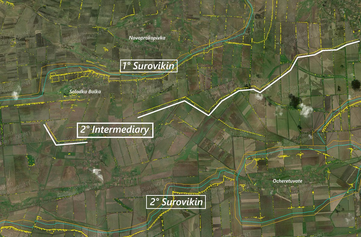
10/🧵
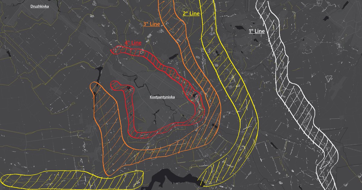
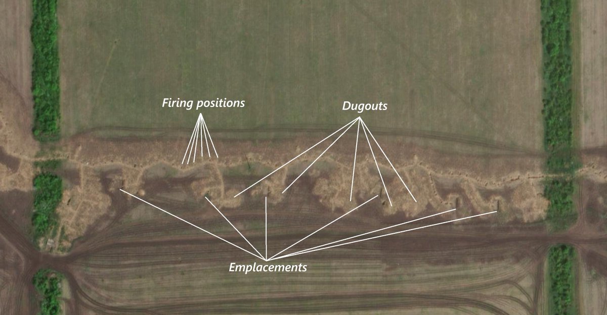
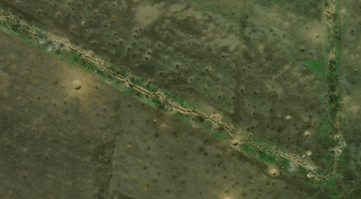
And now we reach the "most fun part".
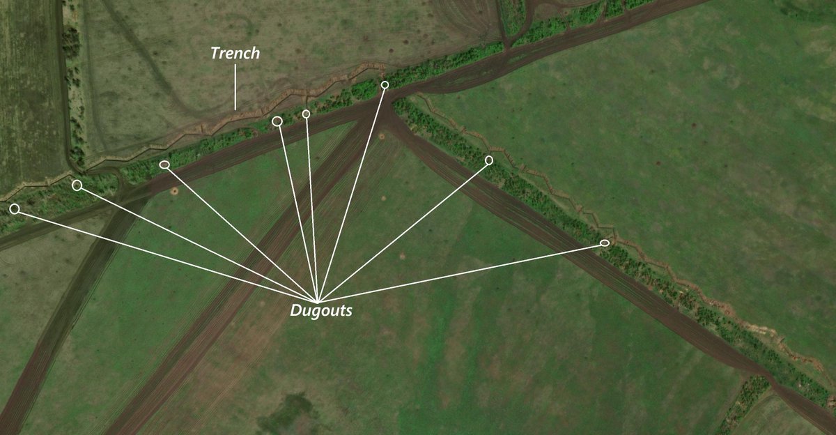
At a depth of about 15-25km lies the 2° and final Surovikin line. This is the line that had to hold. If the other lines were meant to fall, this wasn't, which is why the Russians put a big amount of effort in building it.
Just like the 1° Surovikin, the 2° Surovikin is composed of an anti-tank ditch, a dragon's teeth line and the trenches, but with some peculiarities.
First of all, at least in this section of the front, they were completely covered. If in the 1° Surovikin we could see some covered ways in specific cases, this line is covered from head to toe.
Then, a big amount of firing positions emerging.
Further, a ton of dugouts to house the great number of personnel that would've all retreated and converged to this line of defense.
And finally, many, many emplacements.
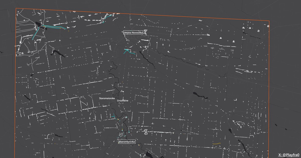
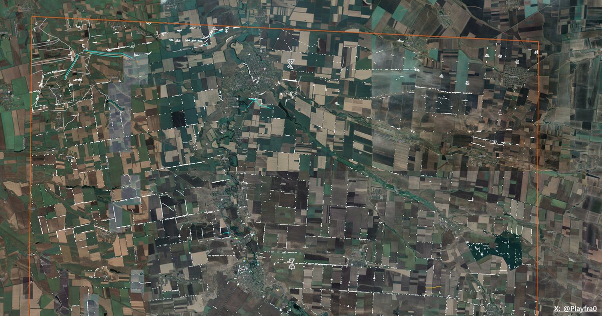
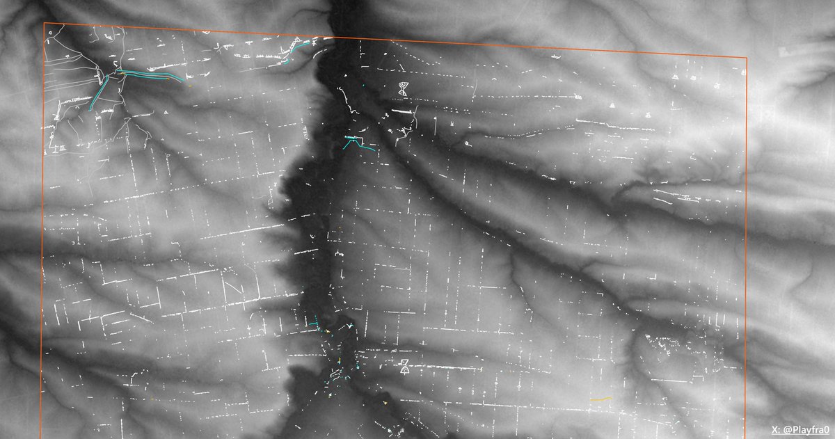
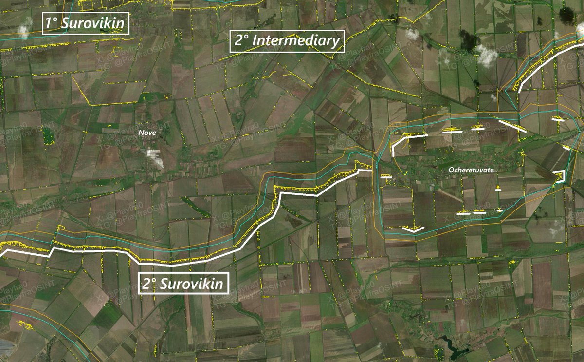
Of the 2° Surovikin is also part the Ocheretuvate ring, as you can see from the picture.
In particular, it is composed of trench systems of the same exact style as the 2° Surovikin line, except that they're independent and always "hug treelines".
And now we reach the "most fun part".
At a depth of about 15-25km lies the 2° and final Surovikin line. This is the line that had to hold. If the other lines were meant to fall, this wasn't, which is why the Russians put a big amount of effort in building it.
Just like the 1° Surovikin, the 2° Surovikin is composed of an anti-tank ditch, a dragon's teeth line and the trenches, but with some peculiarities.
First of all, at least in this section of the front, they were completely covered. If in the 1° Surovikin we could see some covered ways in specific cases, this line is covered from head to toe.
Then, a big amount of firing positions emerging.
Further, a ton of dugouts to house the great number of personnel that would've all retreated and converged to this line of defense.
And finally, many, many emplacements.
Of the 2° Surovikin is also part the Ocheretuvate ring, as you can see from the picture.
In particular, it is composed of trench systems of the same exact style as the 2° Surovikin line, except that they're independent and always "hug treelines".
11/🧵
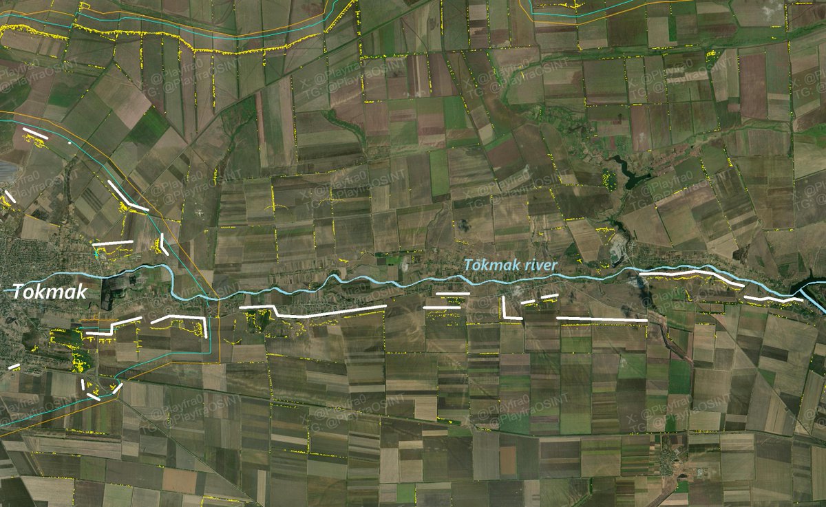
And finally, at 30km of depth, we reach the Tokmak ring - Tokmak river defensive system.
This system was meant to be a strong - and last - fallback line before endless fields, offering less resistance. Even if it is a fallback line, it counts on the very sizeable Tokmak city as a pin, and the Tokmak river with the dominant heights behind. If the Tokmak ring is mostly finished, with its trenches that are extremely similar to the Ocheretuvate ring style, the Tokmak river defenses, even if more numerous in number, are weaker, only consisting of small fighting positions and emplacements in the thousands of treelines and foxholes that have still not been joined together to form a single trench directly guarding the river shore.
Almost all of these little emplacements were not built/were invisible when the most recent satellite imagery we have for the area was taken, so the only way to map them is with Planet or Sentinel satellites, which is exactly what I painfully did for most of the time.
I won't bother to show the Tokmak ring defenses, as they're basically the same as the Ocheretuvate ring defenses, as said.
12/🧵
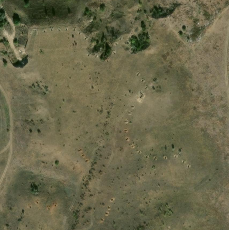
But there is still something missing. Something that most of the analyst continue to miss today about the Ukrainian 2023 counteroffensive and recent times.
The hundreds, if not thousands, of kilometers of "guts", which are complex trench systems extending in the middle of every single treeline, and even foxholes and singular dugouts, all the way to Tokmak.
These were one of the biggest reasons of why the counteroffensive failed.
The Russians knew that they were rapidly losing territory, but they also knew they could count on their numbers. Numbers that let them win the attrition war. And numbers that were transferred into hidden trenches, that the Ukrainians would have to spend thousands of artillery rounds to uncover and destroy.
The big lines could've been very useful, yes, but they were not the idea that Surovikin had in the first place.
This is the actual Surovikin line.

13/🧵
Thank you so much for reading this thread.
Countless hours and massive effort went into this project, so if you would like to support me, this is the best time to do so, even through a simple repost and follow :)
🔎 Interactive map of the Tokmak slice of the Surovikin defensive device: google.com/maps/d/u/0/vie…
📢My Telegram channel: t.me/PlayfraOSINT
• • •
Missing some Tweet in this thread? You can try to
force a refresh